Food self-sufficiency is a major trend in the Middle East and North Africa (MENA) region, which drives rapid development of the agricultural sector. The latter progresses in the wake of rising concerns about poverty, population growth, and reliance on imports .
However, achieving agricultural growth is not an easy feat, as extreme heat poses a challenge to growing crops. Therefore, agribusinesses have been adopting advanced agritech solutions such as remote sensing analytics to support local farmers.
Cosmocel is a producer of specialty solutions for crop nutrition. In response to an increased demand for their products in MENA, they opened a branch in Jordan. To ensure the highest efficiency of nutrient application in the unique climate conditions of this region, they have introduced Satellite Technology Service – an agriculture consulting offer that is completely free of charge for their clients. To derive remote sensing analytics, they use EOSDA Crop Monitoring.
In this case study, we will explore some of the ways in which satellite data, combined with Cosmocel’s expertise, revolutionize agriculture operations.
Overview: About Cosmocel
Cosmocel is an international input supplier with headquarters in the city of Monterrey, Mexico, and a presence in America, Asia, Africa, Oceania, and Europe.
Launched in 1960, the company has been continuously developing by producing and commercializing specialty inputs, soil nutrients, and coadjuvants for the agricultural market. The main focus of the Cosmocel operations has been directed towards efficient growing in tropical regions where high-temperature fluctuations make it especially challenging to meet the market needs for high-quality crops.
Cosmocel’s philosophy is based on the values of continual improvement, efficient technical support, and value generation to the final customer. The company’s products meet the highest standards of ISO 9001:2008 and Good Manufacturing Practices certifications. Cosmocel also operates state-of-the-art laboratories that are accredited by the American Association for Laboratory Accreditation and meet the internationally recognized standard ISO/IEC 17025:2005. Their team of dedicated scientists is committed to ensuring the quality and innovation of their formulations, which are informed by current market trends worldwide.
This case study focuses on the division of Cosmocel in Jordan where experts in agriculture support the local farmers by offering services in satellite imagery analytics.
Problem: Weather Conditions, Need For Remote Crop Evaluation
The quality and amounts of harvest yields in the Middle East depend a lot on weather conditions. Being able to take necessary action at the right time is of the utmost importance to the farmers. Precision also matters. For example, irrigation might facilitate active biomass creation and help deliver nutrients to the plants, but too much of it would only harm the growth stage.
Cosmocel experts in Jordan possess the expertise that farmers seek, so they have been providing consultancy services along with offering their input products. At first, they started by offering soil sampling. The samples were taken from the clients’ fields and then delivered to the evaluation laboratories in the USA. After the necessary lab tests and evaluations were complete, Cosmocel consultants would look at the obtained data and make their recommendations.
However, this approach proved to be inefficient: it took too much time, budget, and couldn’t provide a timely response to issues like disease, fungus, or a sudden temperature rise. Farmers also lacked context. For example, the soil sample taken at a specific place in the field would not give a clear picture of what’s going on in other places of the same field, and it would not provide enough data to predict what to expect during this growing season and how to mitigate the risks.
Another consideration that is inherent to any market is competition. Naturally, Cosmocel clients were surrounded with offers from other input suppliers who also claimed to have proven the effectiveness of their products. Cosmocel needed tools to provide an accurate estimation of their products’ impact to be able to demonstrate the evident effect of crop nutrition.
Finally, Cosmocel sees precision agritech as their leverage for strategic success. Big data analytics in agriculture is becoming increasingly accessible, providing valuable insights for both growers and the companies that support them with detailed observations. That’s why satellite imagery analytics is one of the instruments that was implemented by Cosmocel in search of new growth opportunities, improving business processes, and delivering the highest value to their clients.
Solution: Satellite Technology Service, Expert Advising
Cosmocel has introduced a satellite technology service that is free of charge for the growers that are buying their products. This way, they could provide actionable insights to encourage an easy start in precision agritech practices.
The satellite technology service of Cosmocel Jordan includes:
- Sending monthly reports about current vegetation stage and weather conditions
- Providing historical data and statistics of the field of choice upon request
- Providing additional remote sensing analytics on urgent requests within 24 hours
- In-person visits to the farm and scouting services
The team of agriculture specialists in Cosmocel Jordan has been using EOSDA Crop Monitoring to deliver insightful and responsive consulting to their clients. They have been focusing on certain crop types that are being most actively cultivated in this region, such as date palms and fruits (grapes, peaches, and more).
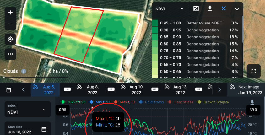
Some of the features that they have been using most often are Monitoring and Weather.
For example, heat stress is one of the risks that growers in Jordan need to address every season. By evaluating the weather along with the NDVI and NDMI field layers, Cosmocel consultants could give recommendations regarding the adjustments of irrigation and a possible choice of nutrients for specific zones within each field.
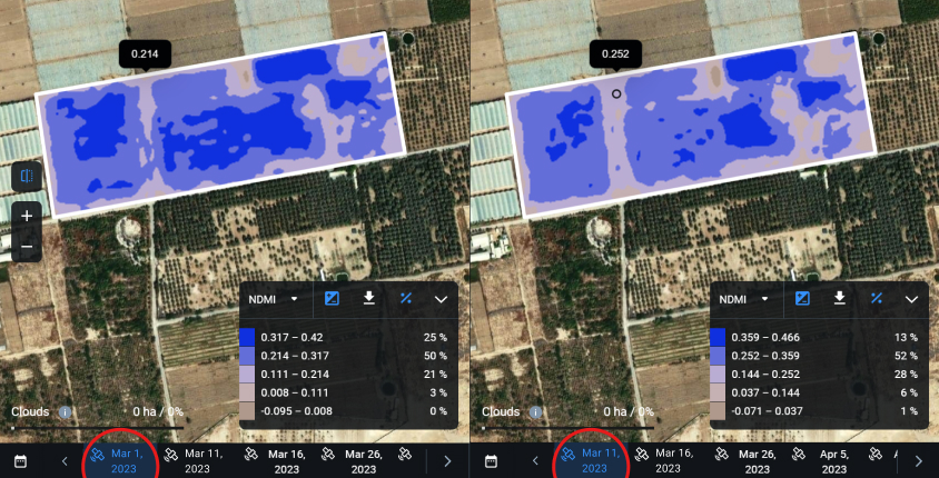
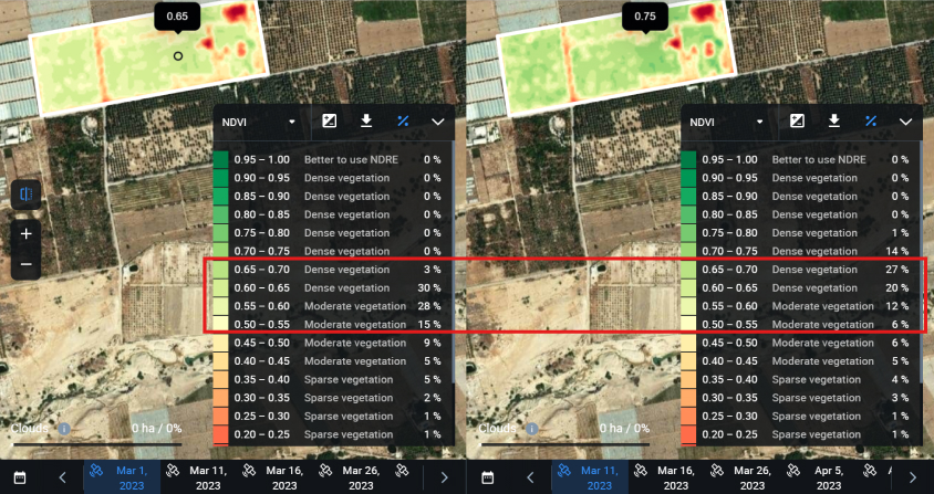
The Split View helps to see the changes in vegetation before and after an event or action took place. For example, this could be a biostimulant application, an increase or decrease in irrigation, or simply the situation before and after the estimated growth stage completion.
The experience of Cosmocel experts with EOSDA Crop Monitoring showed that even the slightest alteration in field maintenance practices like changing the irrigation time spans (e.g. from 3 to 2 hours a day) can drastically change the amount of active biomass in plants. The ability to access the vegetation data in real-time has proven to be of great value to their customers who want to have immediate visibility into the situation on the fields since in tropical climate conditions, every excessive hour of heat counts towards the results of eventual harvesting.
Another useful feature that has been actively used by consultants in Jordan is the sum of Heat Units which can be found in the Weather → Analytics tab in EOSDA Crop Monitoring.
The sum of Heat Units indicates how, when, and how much the total sum of temperature rise affects the crops.
For example, a client has an inquiry. They consider planting 600 hectares of a Medjool palm variety in a certain location. Cosmocel experts look into the current season’s data and compare it with the 5-year statistics from the EOSDA Crop Monitoring platform to advise on the possible productivity of this particular crop type in the designated location.
Let’s say, according to the observed remote sensing and weather data analytics, the growing season in 2022 in this region starts on April 1st, at the time of pollination. The fruits are formed that same week or the next week, after which they need some time to grow.
The correlation between the Heat Units and hours during the growing season period (April 1st to October 1st in our example) gives an idea of whether or not the fruits will have the best conditions to grow. For instance, if the Medjool variety of a date palm needs 2000 Heat Units to fully ripe and the current location gives 2500 Heat Units during this season, the harvesting should begin approximately 1 month earlier than usual (September 1st). However, if due to analytics, the last few years show no more than 1700-1800 Heat Units per season, it becomes too risky to plant Medjool palm in this field because it won’t give the desired yield.
To ensure successful yields, Cosmocel experts are also monitoring other weather values, such as the sum of active temperatures, which should be less than 5 degrees Celsius in an ideal scenario.
The target number of heat units needed until harvesting is calculated according to this formula:
The weather patterns are changing every year, which is why the agriculture consultants at Cosmocel Jordan rely on EOSDA Crop Monitoring to stay updated about the local conditions. This helps them provide accurate advice to their clients based on the current situation.
Outcome: Efficient Growing, Long-Term Cooperation, Competitive Advantage
After implementing remote sensing analytics services, Cosmocel representatives have noticed a significant increase in interest among their clients. Instead of just buying a product, customers reach out and maintain continuous interaction. As a result, 80% of buyers stay with Cosmocel for the long term.
In addition, the Jordan office of Cosmocel has extended its services to cover the entire MENA zone, including countries like Oman, Morocco, and Tunisia. By using satellite imagery analytics powered by EOS Data Analytics, Cosmocel’s agriculture experts can provide remote recommendations to farmers before or instead of visiting their farms in person.
We have seen clients facilitating conversations and seeking our advice on a regular basis. Furthermore, they are interested in what satellite data analytics can bring in the future as they have expressed interest in an even deeper analysis of the state of crops. By employing remote sensing analytics from EOSDA Crop Monitoring, we are building long-term relationships with our customers, while validating the efficiency of our products and establishing highly productive agricultural practices in the Middle East.
Muayyad also mentions that colleagues from other departments in Cosmocel have requested in-depth training to transfer his unique experience in EOSDA Crop Monitoring into delivering continuous value to customers.
Data-driven consulting has helped Cosmocel differentiate itself from competitors. They were able to provide predictive analytics so that farmers can reduce operational costs while increasing harvest yields. Building awareness about the thoughtful usage of Cosmocel products also maintains their reputation as high-quality input suppliers. Cosmocel is satisfied with the ongoing implementation of precision agriculture services and is seeking to expand its expertise in this field in the near future.
Need a solution tailored to your business goals? Book a call with our team to see how we can help.
Detect crop risks earlier with AI-powered field alerts.

More news
EOSDA tracks construction progress in the UAE PAD areas
Managing rapid industrial expansion in the UAE requires accurate data. See how our satellite-based solution helped a client verify construction milestones and reduce inspection costs.

Validating satellite tech for flood analysis and damage mapping in Coimbra
Can satellites improve disaster response? We explored this in the Coimbra district, showing how integrated satellite intelligence can assess flood impacts and fill critical data gaps during a crisis.

EOSDA advances rice field mapping in Indonesia with SAR
EOSDA tested a radar-based approach to improve rice field detection in Indonesia. By integrating SAR and optical data, the team ensured stable monitoring even during peak monsoon months.