Mexican farmers are increasingly considering agricultural insurance to protect their crops due to the high vulnerability of the region to natural disasters . The country’s geographical location, as well as its dependence on agriculture, places crops at risk due to climate change, drought, floods, pest attacks, and extreme weather conditions. Farmers are securing loans from financial institutions that require some kind of guarantee.
Furthermore, the fragmentation of the agricultural industry is experiencing a growing divide, leading to unique requirements for smallholder farms across the country. One key challenge lies in the high transaction costs associated with providing traditional agricultural insurance to these small-scale farmers dispersed throughout a variety of Mexican regions .
FONCOSPA offers multiple types of insurance for agricultural businesses in Mexico, leveraging satellite imagery from EOSDA Crop Monitoring. In this case study, we will take a close look at how remote sensing analytics is used by insurance experts at FONCOSPA to make data-driven decisions on insurance claims.
Overview: About FONCOSPA
FONCOSPA is a Mexican insurance fund established in 2009 with the objective of providing reliable risk protection services to agricultural producers. Its primary mission is to protect the assets of the policyholders efficiently and reliably, thereby enabling them to improve the well-being of themselves and their families. Currently, FONCOSPA operates in 2,000 municipalities in Mexico, with a client base of 267,000 policyholders and 611 insured units.
FONCOSPA offers a comprehensive range of insurance products, including agricultural insurance. This insurance protects producers from various damages to crops such as drought, flooding, excess humidity, frost, hail, hurricanes, pests, diseases, yield deficiency, etc. Additionally, the company provides comprehensive insurance policies for the Mexican agricultural sector, namely investment insurance, plant insurance, expected harvest insurance, investment insurance with performance adjustment to risks before germination, biological insurance, and weather insurance. EOSDA Crop Monitoring was chosen as a technological solution to provide visibility into the insured fields.
Challenges: Environmental Concerns, Multiple Insurance Claims
Currently, FONCOSPA observes that producers are faced with multiple factors that can affect crops. Due to global climate change, less-predictable environmental effects might occur within a short period of time and cause unexpected results. For this reason, more and more farmers are deciding to purchase insurance.
As an insurer, FONCOSPA required a reliable set of tools to evaluate a vast number of claims while measuring different variables accurately for flawless assessments. In addition, these tools had to expedite the processes of evaluation, reporting, and field visits. Consequently, the implementation of EOSDA Crop Monitoring was chosen as the most viable solution because it provides a wide range of instruments to remotely monitor agricultural lands via satellite images, weather reports, team and field management tools, and analytical algorithms.
Solutions: Remote Sensing-Based Assessment, Work In The Field
Upon receiving a notice of an insurance claim, FONCOSPA specialists begin the process required to determine an appropriate response.
Insurance experts use multispectral imagery analytics available in the smart farm platform in this process. To perform a comprehensive analysis of the particular situation, they first conduct research across several fields, in which they have proven data on climactic events, field management practices, and seed distribution patterns. In this way, FONCOSPA can understand how different vegetation indices (numeric values based on surface reflectance registered by satellite sensors) correlate with crop development.
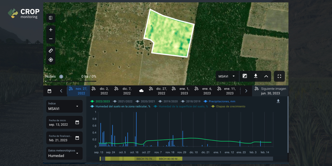
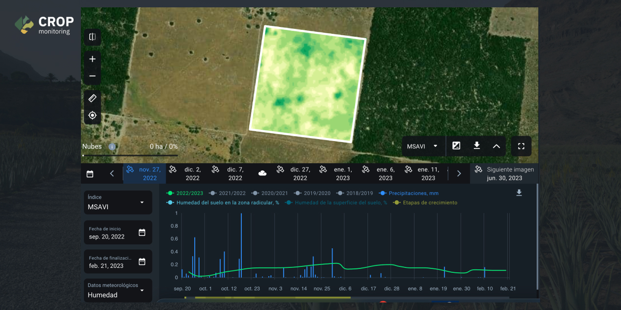
In a case that we are going to review in this case study, FONCOSPA received a claim about crop loss in a soybean field. An investigation was conducted across several soybean fields to understand the vegetation indices dynamics in different stages of the soybean cycle in the designated region. The locations of interest were divided into four sections, which we will refer to as Section 1, Section 2, Section 3, and Section 4 in screenshots below.
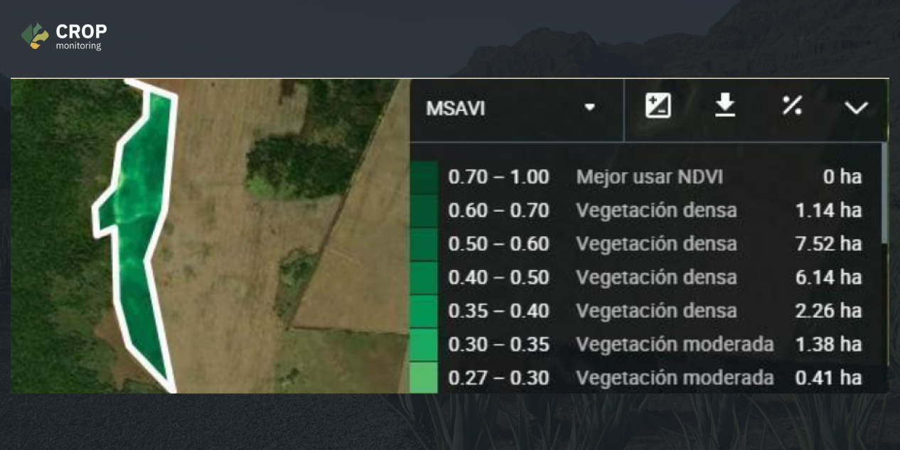
The image above shows that the MSAVI levels during the flowering stage of soybean in this field are around 0.40 to 0.60. By investigating other soybean fields with different yields, they found that the average MSAVI value of soybean at the flowering stage is around 0.55. This data helped them to resolve the crop loss claim.
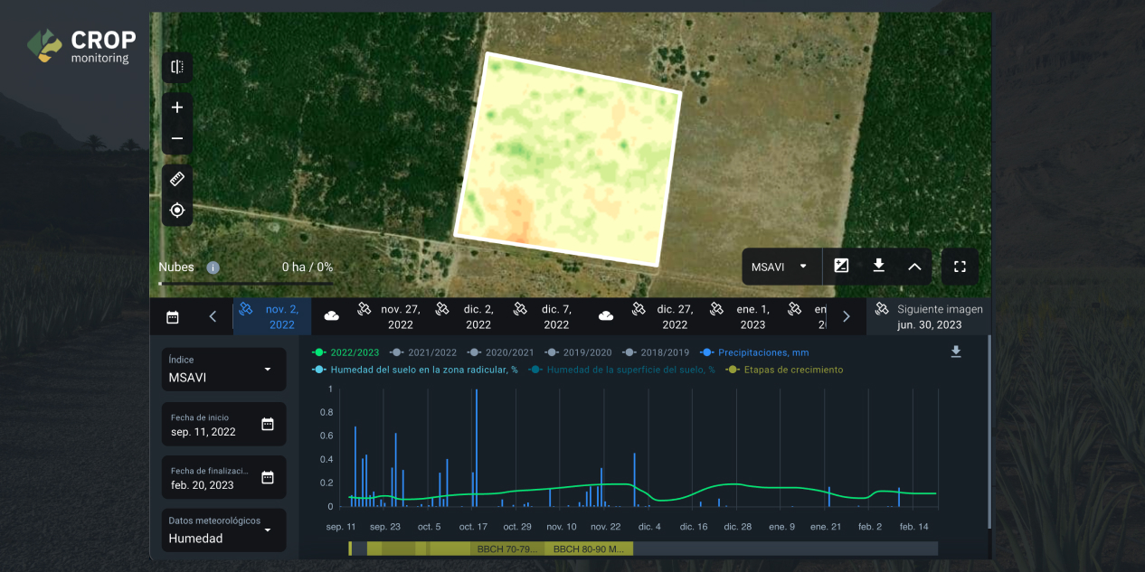
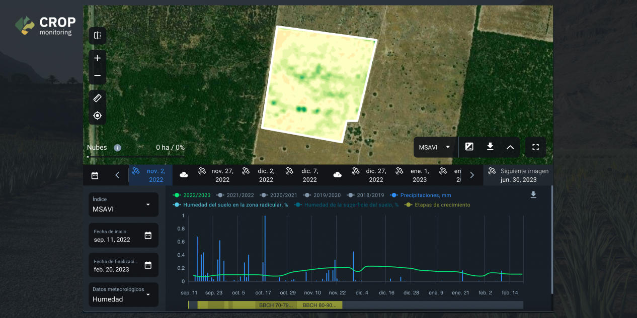
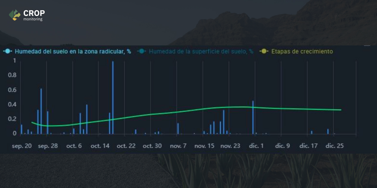
One of FONCOSPA’s policyholders in the 2022-2023 season planted 150 hectares of the Huasteca-400 variety of soybeans in four lots. Sections 1 and 2 were planted on September 10-14, 2022 and Sections 3 and 4 were planted on September 16-20, 2022. The subject of the field crop loss insurance claim was damage caused by Rhizoctonia Solani fungus.
Having located the sections of the area planted in EOSDA Crop Monitoring, which was monitoring the different stages of growth and development of the crop, the characteristics and behavior of temperature, humidity, and precipitation were observed.
The right time of planting determines much of the optimal development of the crop, which is conditioned by the characteristics of the variety, climate (temperature, humidity, rainfall), water availability, soil characteristics, and incidence of pests and diseases, among other factors. If planting is done outside the recommended period, there is a risk of plant stress, the presence of pests and diseases, flower bud abortion, and heterogeneous filling, among others. Planting after the indicated date causes a shortened crop cycle and plant height, with pods produced low to the ground, making mechanical harvesting difficult. In addition, the grain filling period occurs outside the rainy season, thus reducing the productive potential and yield.
Unfortunately, this field was not planted on the right dates according to INIFAP (National Institute of Forestry, Agriculture and Livestock Research), which states that the recommended dates for soybean variety Huasteca-400 in the designated region are from August 1 to August 15.
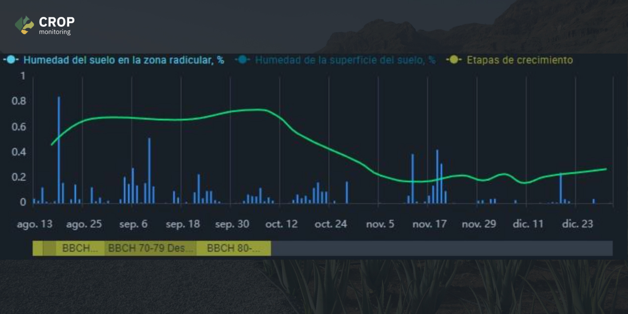
Below, we can observe the difference in soybean development between the two fields. The second screenshot shows correct crop management according to INIFAP standards, resulting in higher indicators than in Section 4.
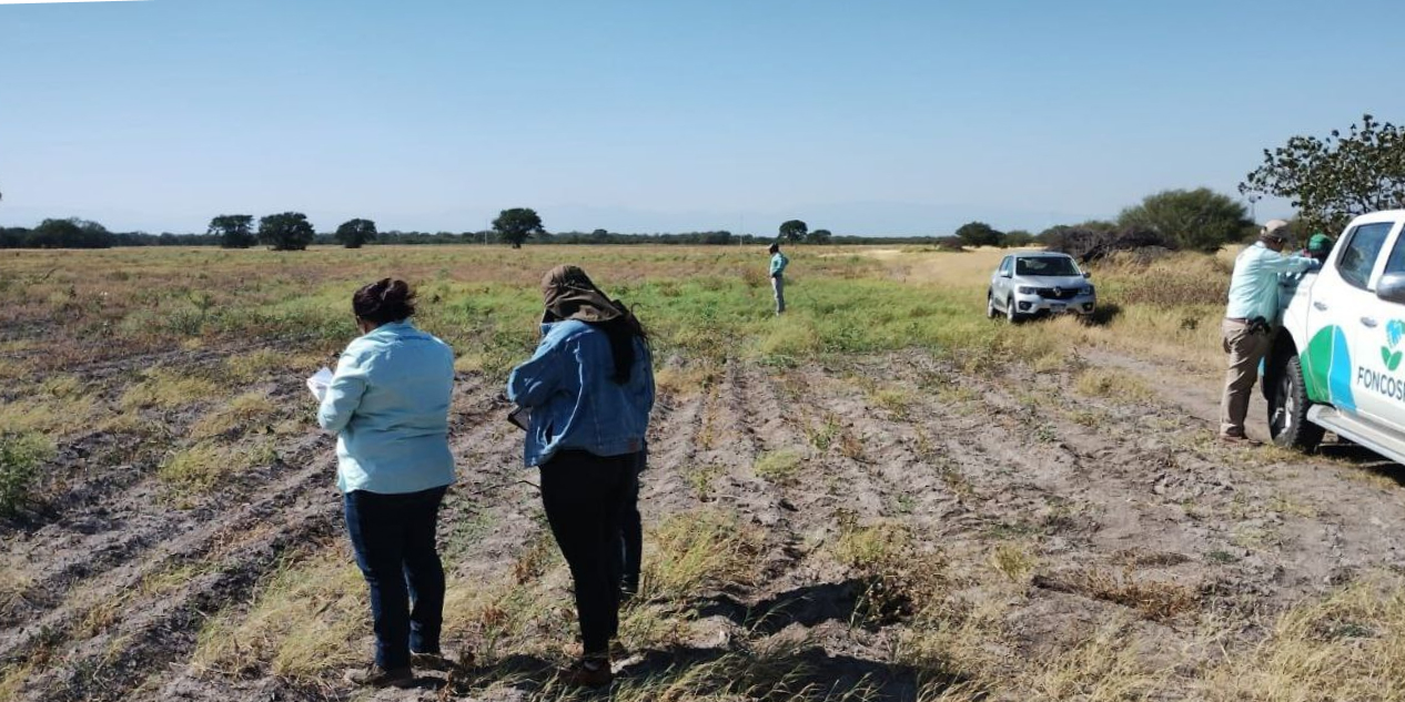
The above is a small example of how to perform analysis prior to the field visit to carry out the forensic investigation. EOSDA Crop Monitoring also helps FONCOSPA to perform field visits, because they must obtain ground evidence on both cases of correct crop development, as well as cases of higher development. Scouting tasks are assigned considering particular geolocated points. After assigning a task to a field expert, scouts visit these points in person and review the present situation to confirm or refute a concern derived from satellite imagery.
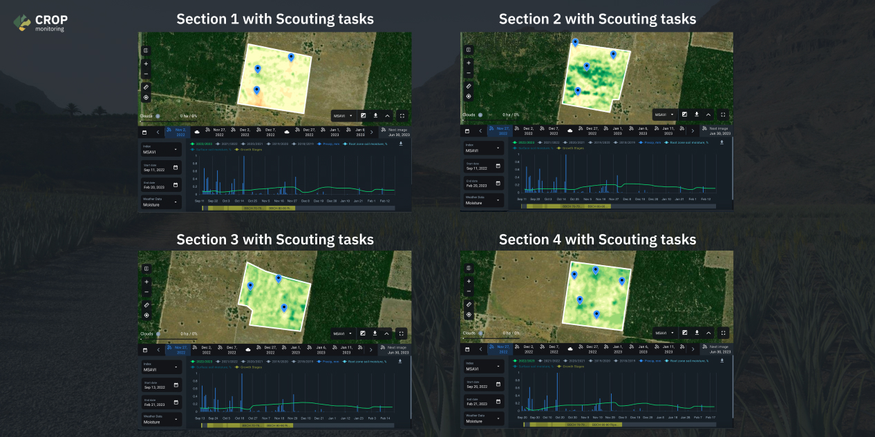
These scouting tasks are important because the marked points are significant, since through the analysis of several satellite images of a field, insurance experts can find the points that had better development and lesser development. Below you can see photos of the field visits according to the Scouting tasks pinpointed above.
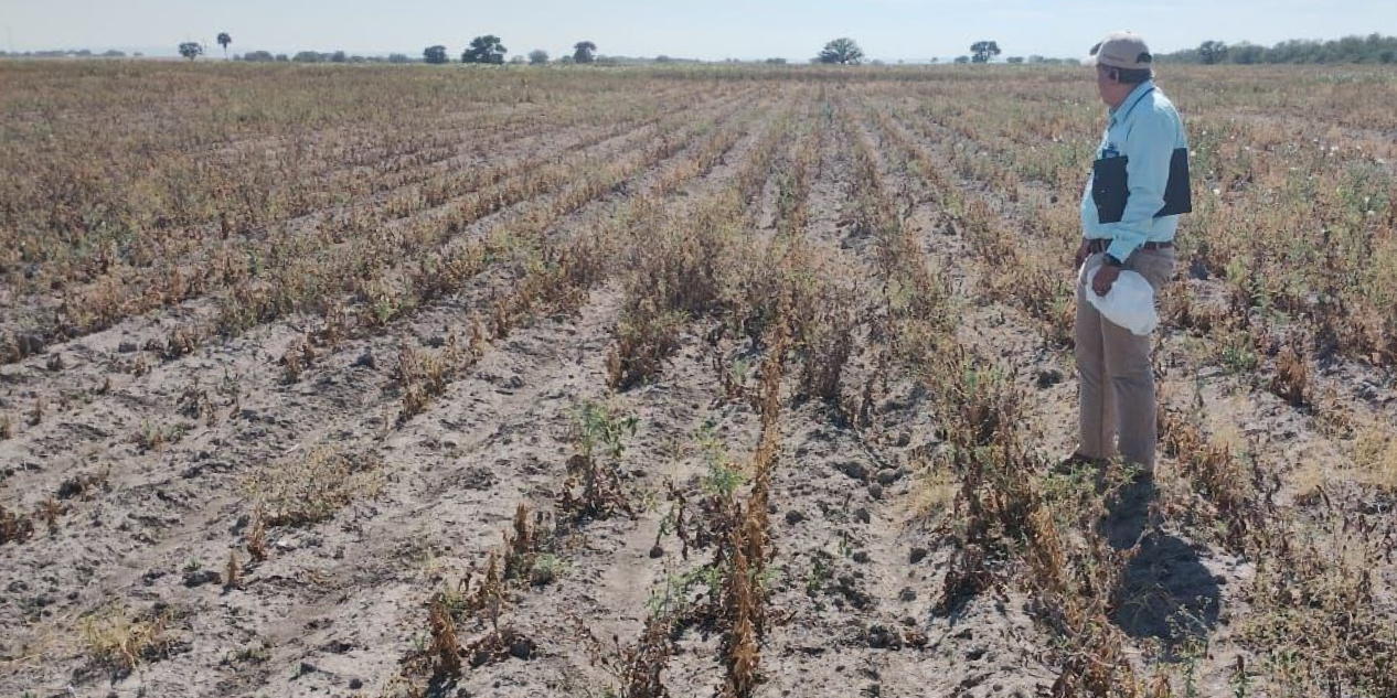
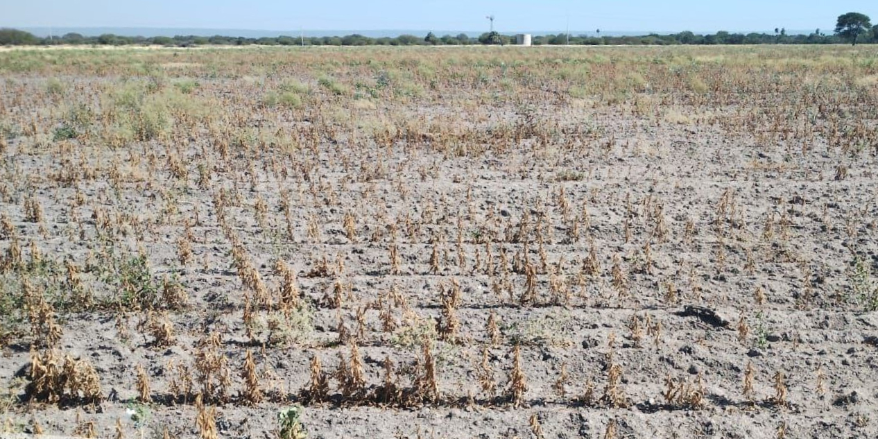
In this claim, Rhizoctonia Solani fungus was only found in minimal proportions, and it was not the determining cause of the deterioration of the crop. Available evidence didn’t suggest any vegetational indicators of appropriate irrigation management during the crop development stage either. Additionally, the biophysical characteristics of the plants did not reflect good nutritional and agronomic management of the crop.
Results: Improved Processes, Insurance Opportunities
FONCOSPA insurance specialists have been using EOSDA Crop Monitoring for the evaluation of claims and they are satisfied with the amount of evidence and management tools they have implemented into their workflow.
As for future plans, during the second year of collaboration with EOSDA Crop Monitoring, FONCOSPA aims to elaborate reports for their policyholders so that the latter could use satellite images and meteorological data to see the present and future threats. In the third stage, FONCOSPA plans to give their policyholders access to EOSDA Crop Monitoring to facilitate correct monitoring of their fields.
Need a solution tailored to your business goals? Book a call with our team to see how we can help.
Detect crop risks earlier with AI-powered field alerts.

More news
EOSDA tracks construction progress in the UAE PAD areas
Managing rapid industrial expansion in the UAE requires accurate data. See how our satellite-based solution helped a client verify construction milestones and reduce inspection costs.

Validating satellite tech for flood analysis and damage mapping in Coimbra
Can satellites improve disaster response? We explored this in the Coimbra district, showing how integrated satellite intelligence can assess flood impacts and fill critical data gaps during a crisis.

EOSDA advances rice field mapping in Indonesia with SAR
EOSDA tested a radar-based approach to improve rice field detection in Indonesia. By integrating SAR and optical data, the team ensured stable monitoring even during peak monsoon months.