Monitor. Сontrol. Prosper — Smart Farm Risk Protection
Oversee crops, access detailed analytics, and make informed decisions — all through our easy-to-use online crop management software.
Agriculture Software for Precision Risk & Resource Management
Optimize Your Farm Decisions with Powerful Аgriculture Software Solutions
EOSDA Crop Monitoring is your go-to precision farming software for smarter, more efficient field management. Detect vegetation risks early, plan farming operations with accurate data, and adjust resource management based on comprehensive digital insights.
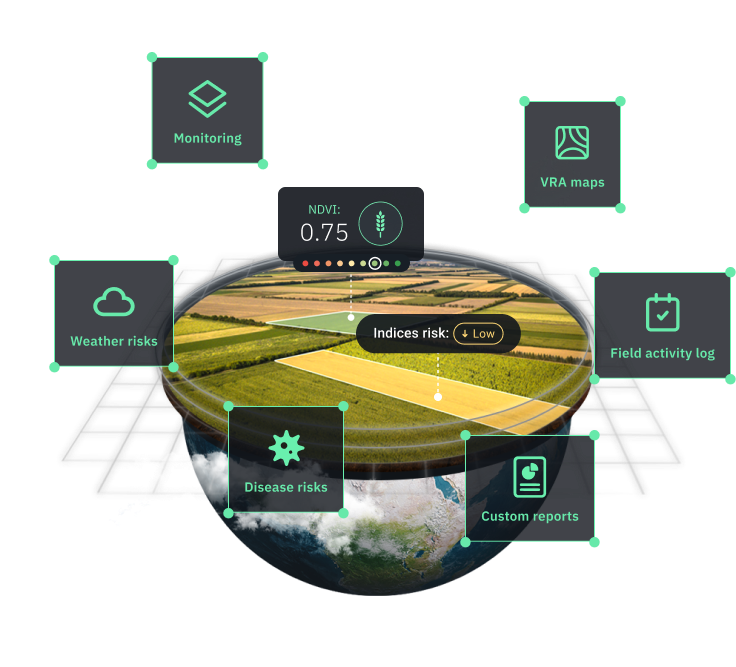
Smart Solutions for Efficient Crop Management
Satellite-Based Agriculture Monitoring Software
Cut back on unnecessary field checks and stay informed from anywhere. Our precision agricultural software delivers regular satellite images to help you assess plant growth and health issues, track vegetation changes, and analyze soil moisture levels from the convenience of your screen.
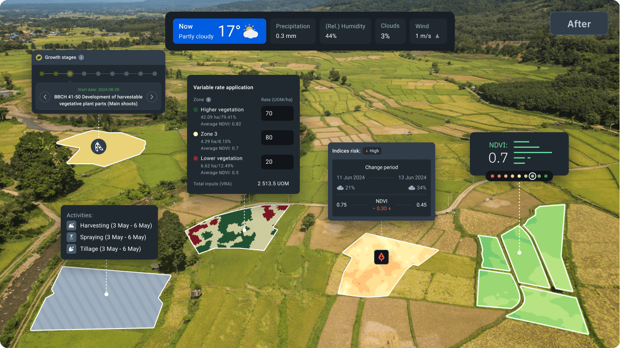
Instant Risk Alerts
Don’t let small issues become big problems. The digital farming system keeps you informed of any potential plant health concerns so you can protect your harvest with speed and precision.
Smarter Resource Allocation
Make the most of your resources with precision agriculture software tools. Use digital Variable Rate Application (VRA) maps to apply fertilizers, water, pesticides, and seeds where needed.
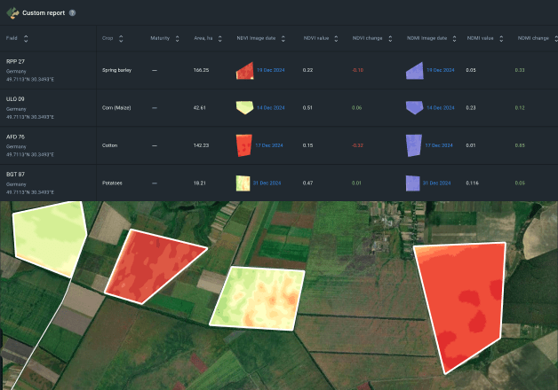
Customizable Analytical Reports
No more struggling with intricate raw data. Generate clear, tailored reports to easily share key insights with your team and make informed decisions supported by reliable agriculture data analysis software.
Behind the Scenes of Our Digital Agriculture Solutions
EOSDA Crop Monitoring is a cloud-based agriculture software product that turns satellite data into practical insights for precision field management. We integrate satellite technology with AI-based analytics and machine learning, backed by expert agronomy knowledge, spotting farming patterns and potential risks unseen by the naked eye.
Essential Software Features for Crop Production
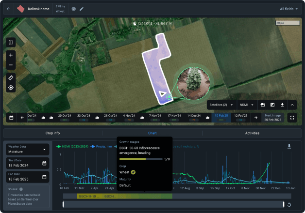
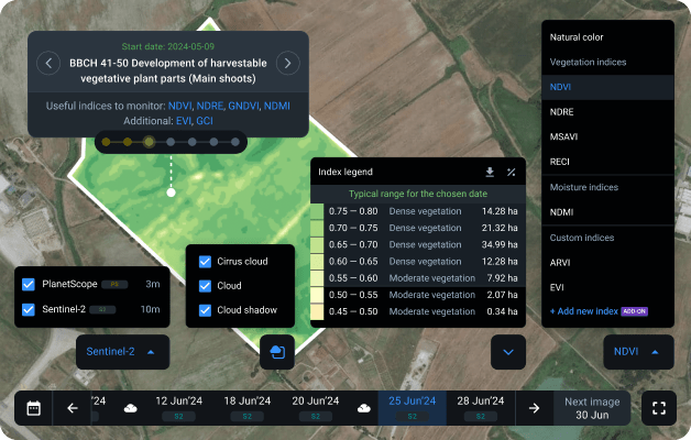
Remote Field Monitoring with Satellite Data
Stay connected to your multiple fields without stepping outside. Use our digital agronomy software to access ready-made insights without complicated setups.
- High-resolution (up to 3 m) satellite imagery by Sentinel-2 and PlanetScope
- New satellite images daily
- Risk notifications delivered on-platform and via email
- Over 10 built-in vegetation indices
- Custom indices available upon request
- Filters to remove clouds, cirrus, and cloud shadows
- Index suggestions matched to plant growth stages
- Typical ranges for NDVI, NDRE, and MSAVI indices
- Accurate model-based yield prediction
- BBCH stages' timeline based on sowing dates
Benefit from our precision agriculture tool: gain a clearer view of vegetation conditions, make faster and more informed decisions, and improve productivity through precision farming practices.
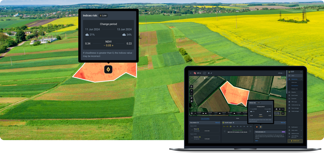
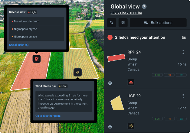
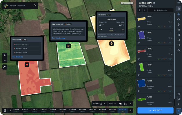
Risk Map
Stay on top of potential agriculture risks: diseases, extreme weather, and shifts in vegetation indices across all your fields. Identify issues early through digital precision ag tools, without day-to-day on-site inspections.
- Comparison of NDVI values between the two newest Sentinel-2 images
- Disease and pest infestation risks based on plant growth stages and weather forecasts
- Extreme weather risks like heat/cold stress, high winds, and heavy rains
Benefit from our precision agriculture tool: catch early warning signs, take swift preventive measures, and protect yields from losses.
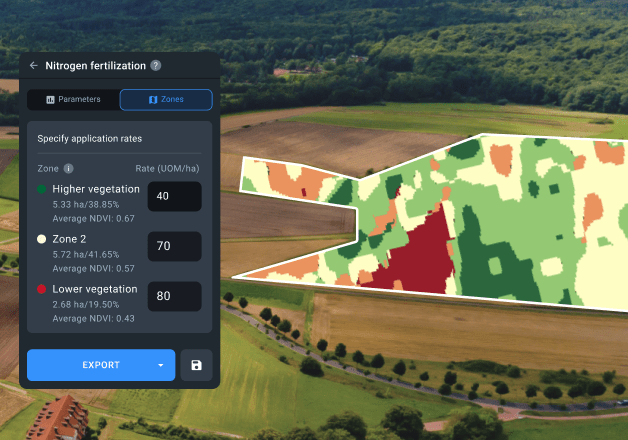
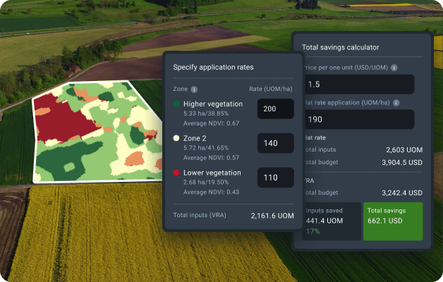
VRA Maps
Optimize agriculture inputs with smart farming software. VRA maps help you apply seeds, fertilizers, pesticides, desiccants, and water with precision — where and how much they are needed — minimizing waste and maximizing farming returns.
- Maps for variable rate seeding
- Maps for variable rate fertilizing
- Maps for variable rate desiccation
- VRA maps based on yields
- Custom and multilayered VRA maps based on NDVI, NDMI, RECl, MSAVI, elevations, or precision ag machinery data
Benefit from our precision agriculture tool: reduce input costs, improve field productivity, and increase your total yield by bringing precision to resource distribution.
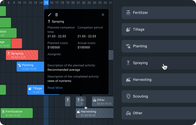
Field Activity Log
Get a complete overview of all your past and current field activities, from tillage and watering to pesticide spraying and scouting. Create tasks, assign them to fields and performers, and monitor progress on a single agriculture software screen.
- Centralized task planning and status tracking software
- Keeping detailed records of supplies and costs
- Seasonal cost analysis with planned vs. actual comparisons
- Downloadable reports for in-depth operational analysis
Benefit from our precision agriculture tool: streamline task tracking and team coordination, optimize costs through precise budgeting, identify issues early and take corrective action, better allocate resources based on clear, organized data.
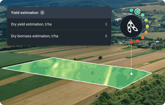
Yield Estimation
Stay ahead of agriculture productivity with the accurate yield estimation tool. Our crop planning software analyzes vegetation type, irrigation details, weather data, and other key farming factors to project yield and biomass 14 days in advance.
- Dry biomass estimation. Available 1–2 weeks after sowing, right after plants emerge above the soil
- Dry yield estimation. Calculated when productive plant parts become visible
- Recommended harvesting date. Available 14 days before the optimal harvest time, based on model predictions
Benefit from our precision agriculture tool: enhance crop management through informed agriculture forecasting, plan fieldwork with confidence, and harvest at the right time to maximize yield.
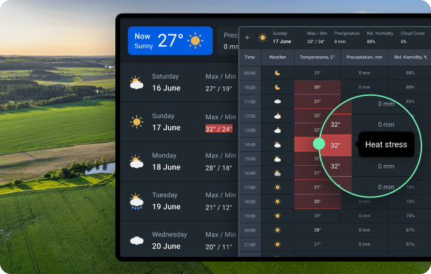
Weather Analytics
Weather conditions impact every stage of agricultural production. With our digital farming tools, you get reliable 14-day forecasts, access to historical data since 1979, and tools to track cold and heat stress. Use this information to schedule critical activities like spraying and tillage more effectively. Integrate ground weather stations to further improve accuracy for your fields.
- Global weather data with a 90x90 meter resolution
- Alerts on weather risks
- Hourly weather forecasts tailored for agriculture
- Weather analytics using historical data from 1979 onward
- Simple integration of ground weather stations
- Weather and vegetation insights on a single digital farming platform
- Data sourced from international providers and advanced forecasting models
- Reports available for download in XLSX format
Benefit from our precision agriculture tool: adjust watering to precipitation, identify and mitigate risks from extreme weather events, and schedule fieldwork with greater precision, avoiding weather disruptions.
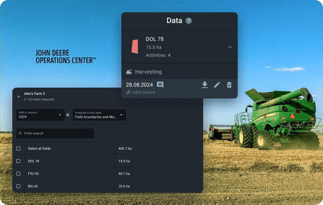
Integration with John Deere Account
Streamline your workflow by automatically connecting your John Deere Operations Center to our precision ag software.
- Bulk transfer of field boundary information collected by your farming equipment
- Access to historical machinery records stored in your John Deere account
Benefit from our precision agriculture tool: simplify agriculture management by reducing manual data entry, set field boundaries to enhance operation precision, optimize field activities like planting, fertilizing, spraying, and harvesting.
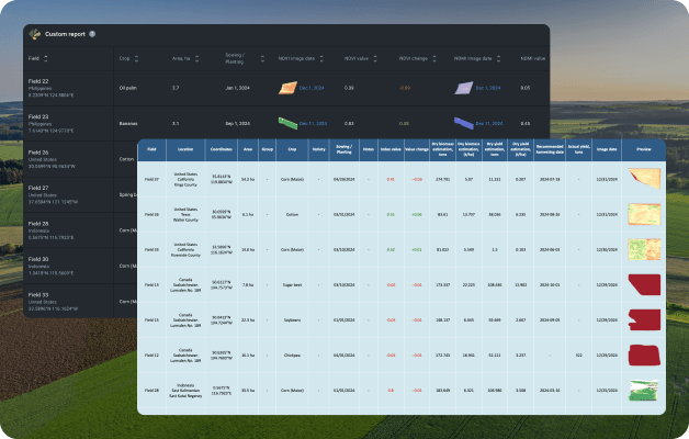
Automatic Reporting
Set up automatic crop productivity reports for a particular field or all your farming lands. Tailor reports to include only the data you find useful.
- Vegetation status tracking for a selected crop on all fields
- Seasonal crop productivity analytics
- Risk-based field data filtering and downloads
Benefit from our precision agriculture tool: get a clear digital overview of operations and fields, tailor reports with the metrics that matter most, stay updated automatically.
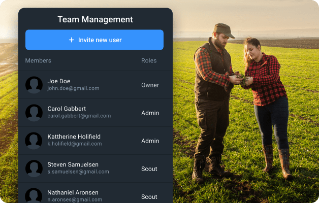
Team Management
Enhance collaboration within your company with role-based access to agriculture software. Share important vegetation data, index changes, and personalized reports with your team to keep everyone informed.
- Support for teams of up to 50 members
- Customizable roles and software access levels
- Task assignments with real-time status updates
- Notifications on task progress
Benefit from our precision agriculture tool: save effort by managing all tasks in one place, track activities remotely, and improve team performance with transparent communication.
Case Studies
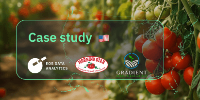
The Morning Star’s Gradient Implements Remote Sensing
The Morning Star combines in-ground sensor data with satellite imagery analytics to ensure proper irrigation and increase tomato yields in California.
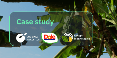
Dole Asia’s Leap Into AgTech With Agright Technologies
Agright Technologies assists Dole Sunshine in the Philippines in controlling fungi on banana plantations using satellite imagery analytics offered by EOSDA Crop Monitoring.
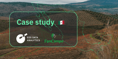
FANCAMPO Mexico Uses Remote Sensing For Crop Insurance
Agricultural insurance in Mexico rises to the next level with the FANCAMPO fund employing satellite imagery analytics through EOSDA Crop Monitoring for damage claims assessment.
Land Biomass In Brazil Calculated Using Remote Sensing
The Brazilian scientists participated in the EOSDA Academic Outreach Program to use satellite imagery analytics to calculate land biomass, predict productivity, and apply fertilizers in pasture areas.
Complete Farmer Connects 5,000+ Farmers To SatTech
Complete Farmer harnesses satellite imagery analytics through the EOSDA Crop Monitoring API, fostering a thriving network of farmers across Africa, leading to remarkable improvements in crop yields.

Space Monitoring For Green Plantains In Rainfall Season
A new triple-impact enterprise in Nicaragua FINCATECH has committed to promoting sustainable digital agriculture by implementing EOSDA Crop Monitoring and turning satellite data analytics into actionable recommendations.
SatTech Plus Ground Data For Agri-Advisors In Portugal
The agritech company helps local growers to adjust crop yield strategies in Portugal, Chile, and Spain by complementing their ground sensors with satellite data analytics from EOSDA Crop Monitoring.
Satellite Analytics For Water Use Efficiency Services
Chilean company Eficagua started using satellite imagery analytics, particularly NDVI analysis of regular and high-resolution imagery of client fields, to make corrections to its precision irrigation program and provide more services.