Satellite Monitoring For NGOs And NPOs
Driven by the mission to solve planetary crises, non-governmental and non-profit organizations often have a lot on their plates and a gaping hole in their budgets.
Applying the art of geospatial analytics on a daily basis is a shortcut to rationalizing efforts and accomplishing goals. With EOSDA, you can become an agent of change in environment protection, sustainable agriculture development, and other key areas, exploiting the gifts of space for the planet's good.
Key Goals
Promote sustainable development
Preserve fertile soils and environment
Fight rural poverty and protect farmer rights in developing countries
Trace climate change and its impact on the environment
Educate on sustainable practices
NPO and NGO Activities
Environmental NGOs and NPOs play a crucial role in tackling global warming, pollution, biodiversity loss, resource deficit, and other climate issues. They are the catalysts of change empowering communities to live sustainably through practical solutions, awareness-raising activities, and environmental educational campaigns.
With a rising population, depleting arable lands, and resource-intensive farming in place, famine is already at the door. Agricultural NGOs and non-profit organizations are acting as intermediaries struggling to band governments and communities together to grow a more resilient and sustainable global food system.
Powerful EOSDA Tools for Use by NGOs and NPOs
The stark reality for most non-profit and non-governmental organizations is that tight budgets and limited data and resources are getting in the way of great deeds. We, at EOSDA, believe the solution is within reach: tapping into the huge potential of satellite imagery analytics can plug critical information gaps and enhance NGOs' role and efforts on all fronts: environment protection, agriculture development, and disaster management. Provide expert advice to states and IGOs, influence decision-making, and raise awareness of major issues by integrating our scalable monitoring tools:

Challenges Faced by NGOs and NPOs: How EOSDA Helps
Lack of accurate data and limited resources are common bottlenecks that keep non-profit and non-governmental organizations from delivering high-impact and sustained results.
A wealth of current and historical satellite data by EOSDA can help bridge the information gaps, ensuring greater confidence, precision, and timeliness of the decision-making process.
- Shape data-driven strategies and evaluate the outcome of interventions.
- Prove the viability and importance of your initiatives to partners, investors, states, or IGOs.
- Confirm the severity of environmental, agricultural, humanitarian issues.
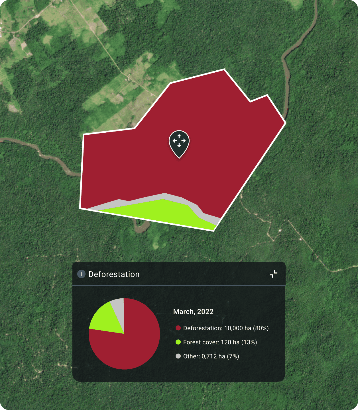
- Showcase dramatic crop and forest cover changes caused by human action and climate change.
NPOs and NGOs require global data to scale up efforts and double down on their role as advisers and facilitators in global issues.
On a mission to provide collective goods to those in need, international NGOs undertake projects that require a global perspective or comparative analysis at various spatial levels. Our solutions are the answer to your scalability issues:
- Agriculture NGOs can integrate EOSDA Crop Monitoring in monitoring activities to remotely observe 93% of the world's croplands.
- Our bespoke services are empowering NGOs to positively impact food security at the regional, national, or continent level, e.g. predict yields to avert food shortages.
In an effort to train communities on using smart tech novelties to improve financial well-being and benefit environment, non-profit organizations often hit a brick wall of conservatism and distrust.
EOSDA Crop Monitoring comes in handy to bridge knowledge gaps and dispel concerns around satellite innovations within farming communities. The platform has intuitive interface and turns complex data into accessible insights about crop health, soil moisture, weather, and other agricultural variables, enabling better farming techniques. To educate growers on how to go off the beaten track and grow sustainably, NGOs and EOSDA can develop special training to accelerate technology adoption together.
EOSDA Offerings for Sustainable Agriculture Development NGOs
Satellite data is an untapped source of accurate and affordable insights ideal for a wide range of monitoring and evaluation activities of NGOs. Together with EOSDA, you can deliver on your NGO role as a thrust to boosting sustainable agriculture development, improving food security, and lifting the most vulnerable ones out of poverty.
Crop Yield Estimation:
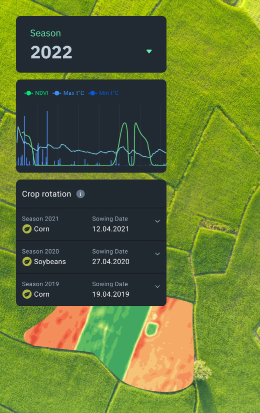
EOSDA Crop Monitoring, rich in agri-data, can be used by agricultural non-profit organizations to assess crop yield and monitor crop conditions. Armed with the latest updates on vegetation levels and vegetation trends across seasons, you can run interventions targeting resource abuse, poor crop management, and other issues coming in the way of sustainable farming.
Weather Monitoring:
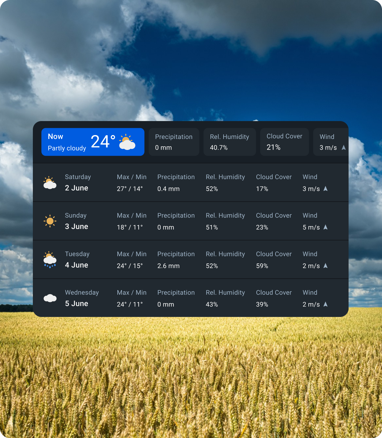
Accurate weather data is central to NGO programs helping agriculture communities become more climate-resilient. Utilize detailed weather forecasts on EOSDA Crop Monitoring to carefully plan for the coming weather and maintain sustainable yields, rain or shine. Weather-based approach increases crop management and disease risk management efficiency.
Irrigation Management:
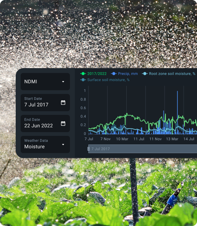
Thanks to EOSDA Crop Monitoring, NGOs can maximize efforts aimed at sustainable water use in agriculture. Having access to a sea of soil moisture data that dates back to 2002, users can dive deep into irrigation processes: evaluate the watering system efficiency, adopt variable-rate irrigation, and reduce environmental footprint.
Precision Agriculture Uptake:
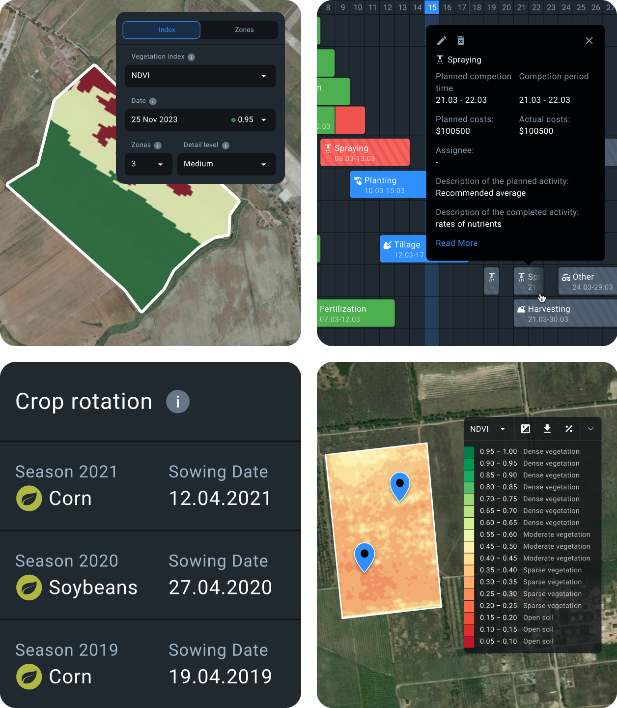
Every inch of a field is rich in meaningful data, and EOSDA Crop Monitoring allows to access all of it in one place. Have vegetation indices, historical weather and forecasts, soil moisture, crop rotation and field activities data at your fingertips to implement precision farming practices, measure their progress and efficiency, and optimize management strategies.
Land Use Mapping:
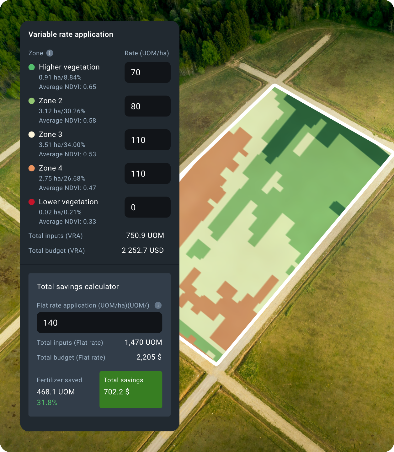
EOSDA Crop Monitoring allows for cropland mapping and monitoring changes in cultivated land use. NGOs working in the agriculture sector can also build satellite-based vegetation and productivity maps for variable-rate application of inputs, more efficient soil sampling, and crop anomaly detection. What takes a few minutes of your time can translate into massive cost and resource savings.
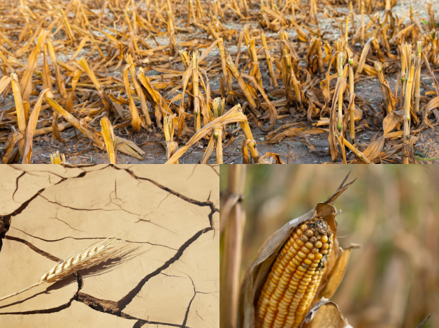
Compensation for Crop Damage:
Agricultural non-governmental organizations and NPOs seek to develop insurance schemes that would buffer crop failures caused by weather shocks, pests, diseases, or wildlife migration and promote farmers' livelihood. Historical crop and weather data on EOSDA Crop Monitoring can be used to estimate risks and design payout grids, while the Scouting feature will be helpful in claim validation.
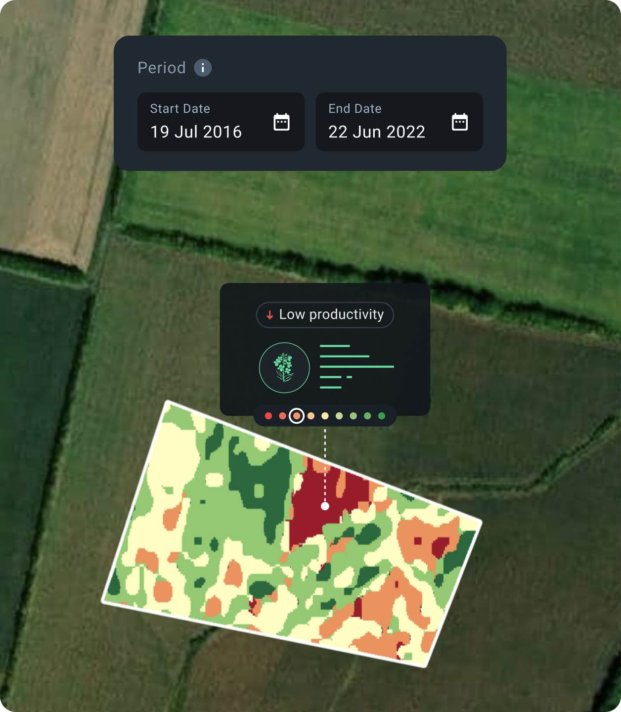
Soil Monitoring:
Given the major role soils play in feeding the world, NGOs put efforts into promotion of sustainable practices beneficial to farmers' income and soil fertility. With our platform's productivity maps, you can detect low-productive field areas for precise soil sampling, trace changes in soil productivity, and evaluate the efficiency of soil management practices to make productivity-enhancing amends.
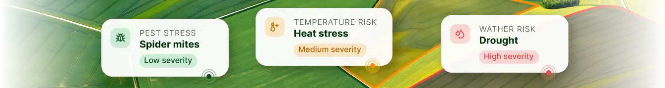
Pest and Disease Control:
Effortlessly unlock a treasure trove of valuable crop health information with EOSDA Crop Monitoring to reveal pests and diseases before they cause major harm to plants. On the platform, non-profit agricultural organizations can regularly monitor crop conditions for timely response and proper allocation of crop protection agents, especially in regions with limited supply.
Farmer Training:
Working shoulder to shoulder with governments, donors, and educational institutions, NGOs aim to promote precision farming as the sustainable way forward in agriculture. Let EOSDA Crop Monitoring make a strong case for adopting better farming techniques: educate on how to leverage technology, prove the viability of novel methods with facts, e.g. vegetation maps of fields before and after the VRA use will say it all.
What We Offer to Environmental and Disaster Relief NGOs
EOSDA tools can support a wide spectrum of environment-focused NGOs' activities, bringing reliable ecosystem intelligence to help understand impacts, risks, and see opportunities. Whatever mission you put your mind to — from raising awareness of climate change effects to framing environmental conservation policies or mobilizing collective actions to build disaster-resilient communities — our solutions will help you do it first-rate.
Disaster Response and Damage Assessment:
Satellite data enables rapid and accurate mapping and damage estimation that can be leveraged by non-profit organizations for humanitarian aid in natural disasters. Use EOSDA solutions to map ongoing calamities, predict their scale and path for timely warning and evacuation efforts; visualize and measure the damage caused for fundraising and recovery planning.
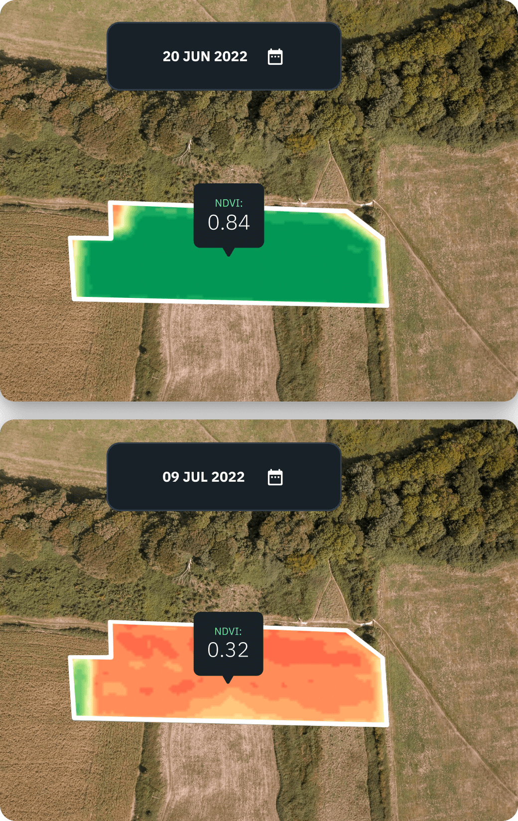
Measuring the Climate Change Impact:
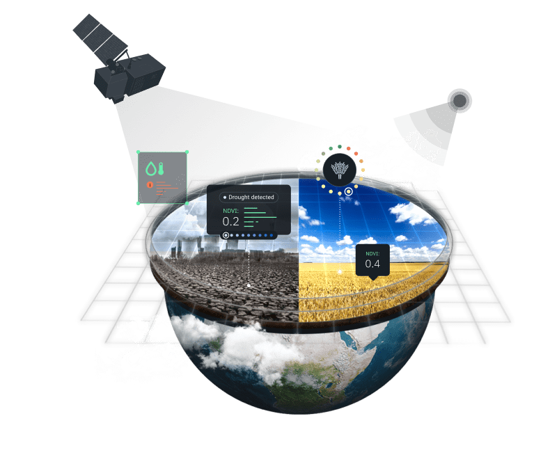
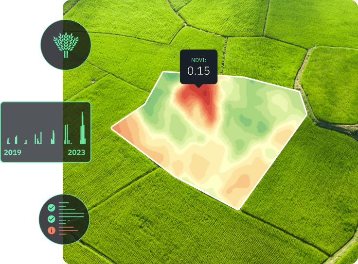
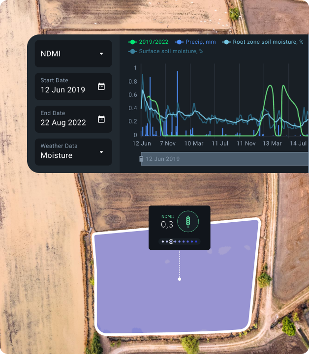
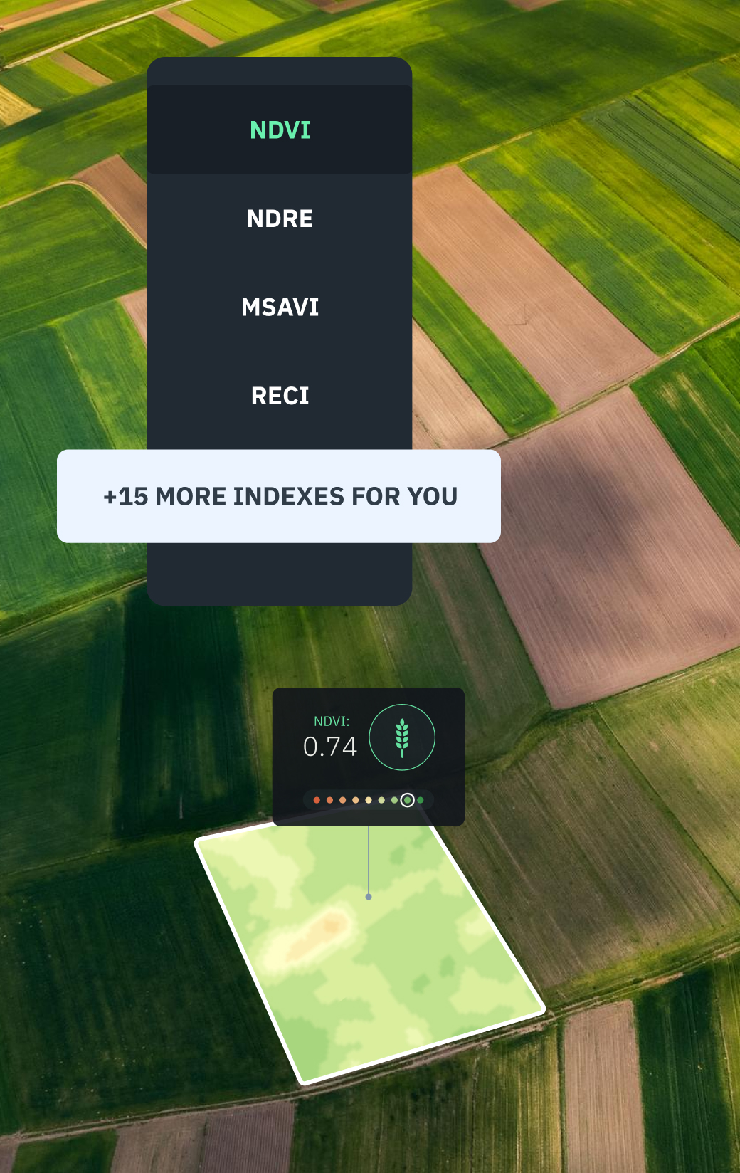
Satellites help to chart climate-induced changes that can be swiftly visualized using our platform's Split View feature. By comparing a pair of satellite images from different dates, environmental NGOs can assess the impact of droughts, floods, wildfires, and zero in on vegetation changes with a set of vegetation indices (NDVI, NDRE, MSAVI, RECl, and NDMI).
Carbon Management:
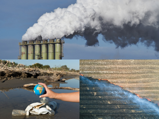
EOSDA solutions are able to strengthen the environmental advocacy role of non-profit organizations by showcasing the scale of detrimental human impact on the carbon cycle, such as deforestation, fossil fuel use, and soil-disturbing farming practices, thereby promoting carbon-reduction policies and initiatives.
Disaster Mitigation:
EOSDA ensures access to timely, reliable data and analytics tools that help NGOs in natural disaster studies and risk assessment. Analyze historical weather and satellite data on past storms, floods, wildfires, landslides, and other calamities to identify disaster patterns and risk factors, pinpoint and monitor areas at risk, and take preventive measures.
Environmental Monitoring:
To overcome the limitations of ground observations, environment-focused NGOs turn to satellites for overseeing human impact on nature's ecosystems — deforestation, land use change, water and air pollution — to conserve natural resources and protect biodiversity. For instance, NDWI is ideal for water turbidity monitoring, while EOSDA Forest Monitoring informs on greenhouse gas levels and forest health risks.
Research Support:
By sharing access to EOSDA digital platforms directly or via API, environmental non-governmental organizations can contribute to a wide range of research and educational projects, e.g. monitoring forest cover changes or measuring climate impact on wildlife habitats. Use reliable satellite data to raise awareness, encourage research and development of game-changing environmental solutions.
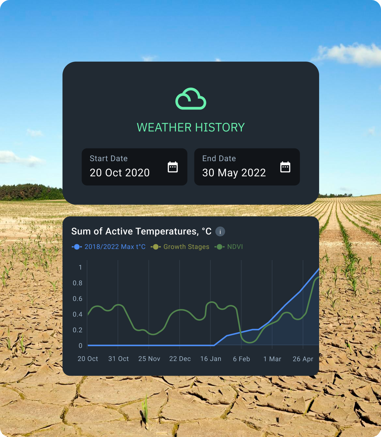
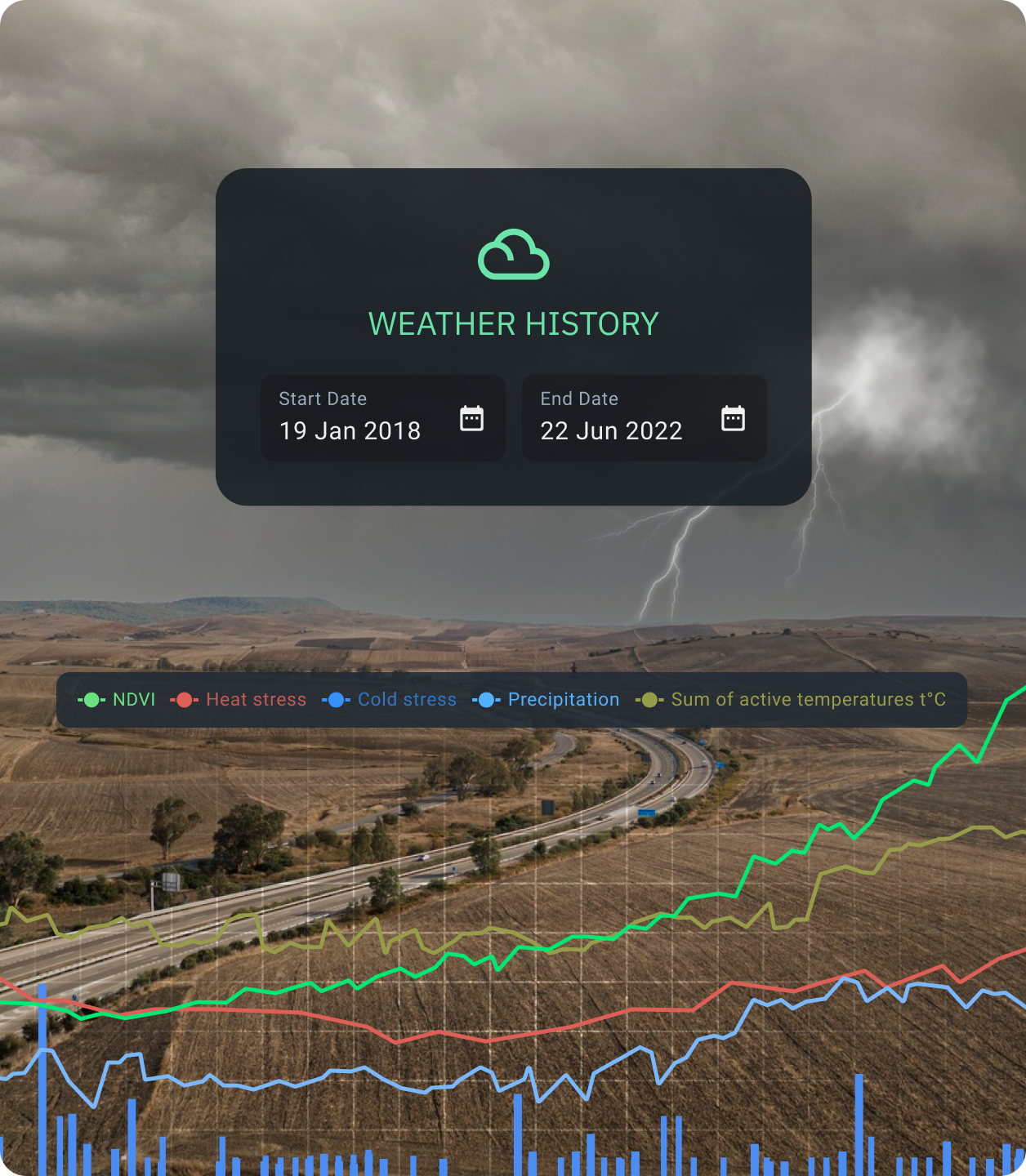
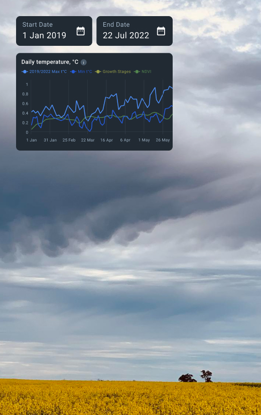
Climate Monitoring:
EOSDA Crop Monitoring offers lavish historical weather datasets for monitoring and analysis of climate variables (temperature, precipitations, etc.). Based on it, non-profit environmental organizations can identify long- and short-term weather trends and correlate them to other ecosystem variations (e.g. vegetation dynamics), monitor droughts, floods, wildfires, etc.
Urban Planning:
Satellite-based services allow to monitor urban growth, land use, and urban impact on the environment as well as identify high-risk areas prone to natural disasters while planning new infrastructure. Equipped with a bird's eye view from space, non-profit organizations can foster more sustainable and safer cities responsive to human and environment needs.
Water Management:
Water scarcity is already affecting half a billion people, and it's only natural that NGOs seek tools for proper environmental resource management. EOSDA Crop Monitoring offers reliable plant and soil moisture data helpful in detecting areas at risk of water scarcity and measuring water supply and demand to ensure sustainable water use and water waste minimization.
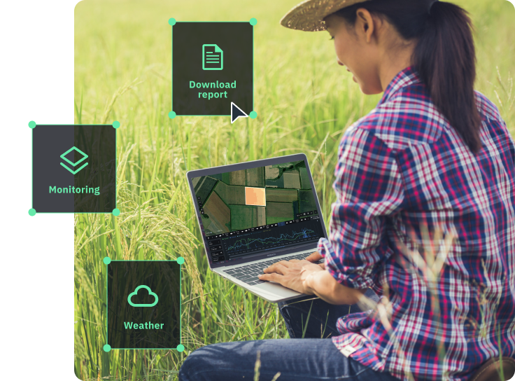
Useful Functions for Non-profits and NGOs

Bespoke Satellite-Driven Services for NPOs and NGOs

API
EOSDA Crop Monitoring API is another way to access reliable agri-data featuring an extended list of satellite imagery sources and vegetation indices, historical weather observations and forecasts. By integrating our API with in-house software, farming and environmental NGOs can enrich it with data and bring to life customized solutions for the communities' needs. Warning citizens of potential droughts or floods in their region, alerting farmers to crop threats that require immediate action are only some of the API data applications.

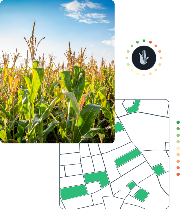
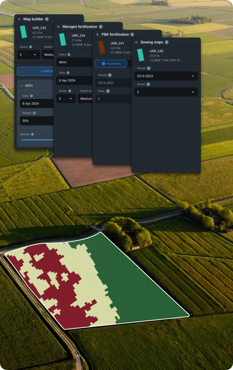
Crop Classification
EOSDA delivers crop type maps with up to 90% accuracy for past and current seasons, enabling field productivity analysis and tailoring of sustainable management practices based on specific cultivated crops. Crop classification yields great value to agricultural non-profit organizations which can justify advice on crop rotation adjustments, assess financial feasibility of growing certain crop types, and analyze environmental impacts of crop cultivation.

Field Boundaries Detection
Accurate plot boundary data is a starting point for any field-level application of sustainable practices promoted by agriculture NGOs. Using field maps retrieved by our AI algorithms from spaceborne data, they can enhance crop health and productivity monitoring, oversee the efficiency of proposed farming strategies at individual plots, and unlock farmers' access to Payment for ecosystem services (PES) programs for additional income.

Advanced Soil Moisture Analytics
Knowing what's going on in the soil is key to improving things above the ground. Thanks to the scalable EOSDA solution, your NGO can keep tabs on surface- and root-level soil moisture, helping farmer communities reach agricultural and environmental goals. Stay updated on drought trends and flood risks, optimize irrigation, select the best crops and dates for planting, and predict climate change patterns to craft mitigation strategies.

Yield Prediction
Our AI-based yield predictions achieve 85-95% accuracy, empowering non-profits to address major food security issues at various scales. Identify potential food-related risks in the region, establish yield gaps, and come up with effective solutions to drive sustainable intensification of agriculture. Crop yield forecasts prove instrumental in ensuring better post-harvest management, access to fair markets and prices for smallholder farmers, as well as in-depth analysis of factors hampering crop productivity.

White Label
White Label service is a shortcut to getting yourself a viable tested product at zero development cost. Our team will customize what's above and under the hood and help you kickstart your own precision ag platform.

Partnership Opportunities
Joining forces with a mission-driven EOS Data Analytics team can take your NGO a long way in bringing sustainable development goals to the masses and showcasing the many environmental and agricultural benefits they provide.
Our demos, webinars, training, and all-around tech and marketing support will help your team and partners befriend satellite technology and make it work for you!
Case Studies
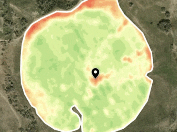
EOSDA solution for environmental protection agency in Wyoming, USA
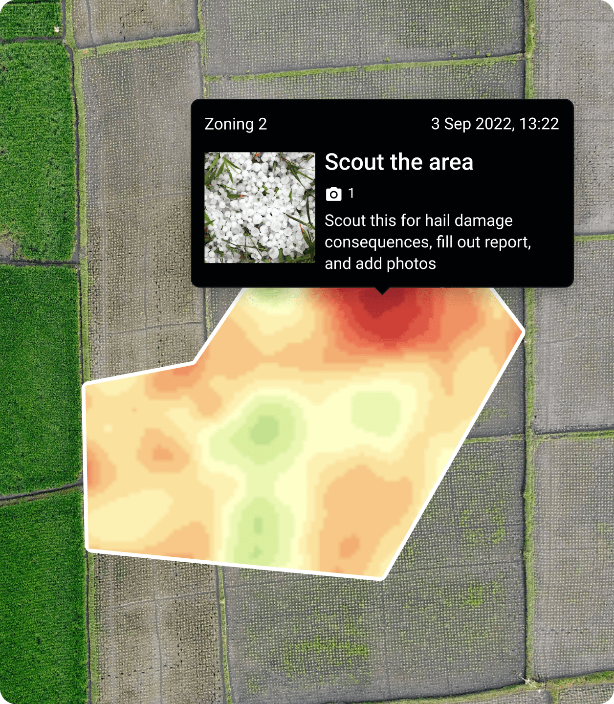
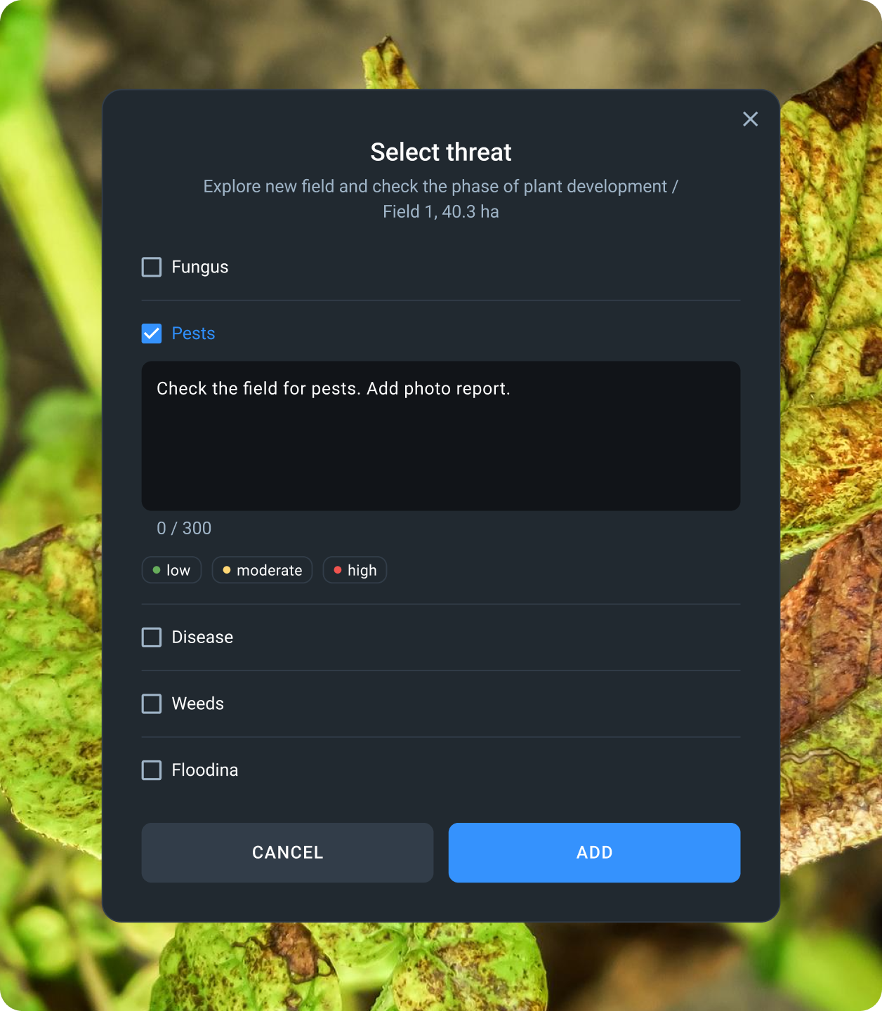
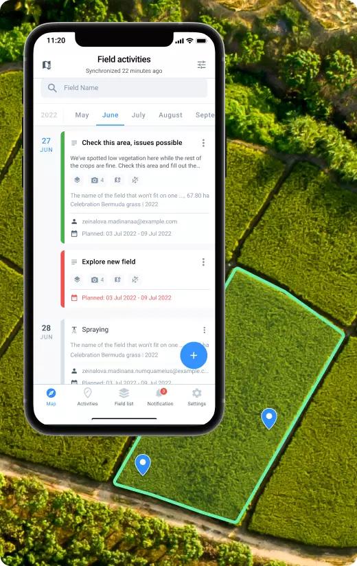
- A spike in landowner claims of crop damage caused by big game increased the agency's workload, encouraging them to find a reliable data-rich monitoring solution that would automate daily operations and facilitate claim validation.
- The agency enhanced claim processing with our Scouting feature. Now, workers mark vegetation anomalies on a field map and assign scouts to check the area. The data collected by scouts on site (damage type, crop density, soil moisture), vegetation maps, and photos of the damage are further added to the claim verification report and presented to the agency committee and landowners.
Stage 1: Agency workers spotted areas with lower vegetation compared to the rest of the field.
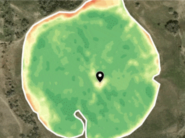
Stage 2: A scout was assigned to inspect problem areas and determine what might have caused the issue. Photos made in the field were attached to the scouting report on EOSDA Crop Monitoring.
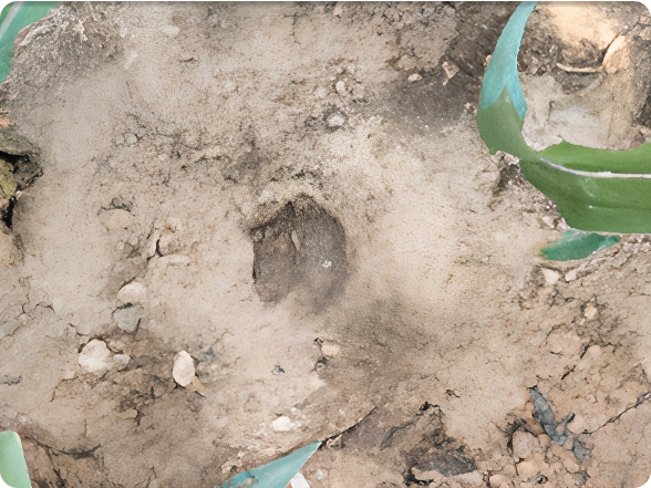
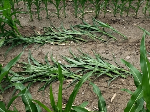
Cost, time and resource saving while handling crop damage claims. The agency cut down fuel expenses and saved scout labor by dispatching workers to problem areas only. Based on the photos of elk damage to crops, the environmental protection agency was able to identify areas prone to wildlife damage and suggest installing fences to protect future yields.
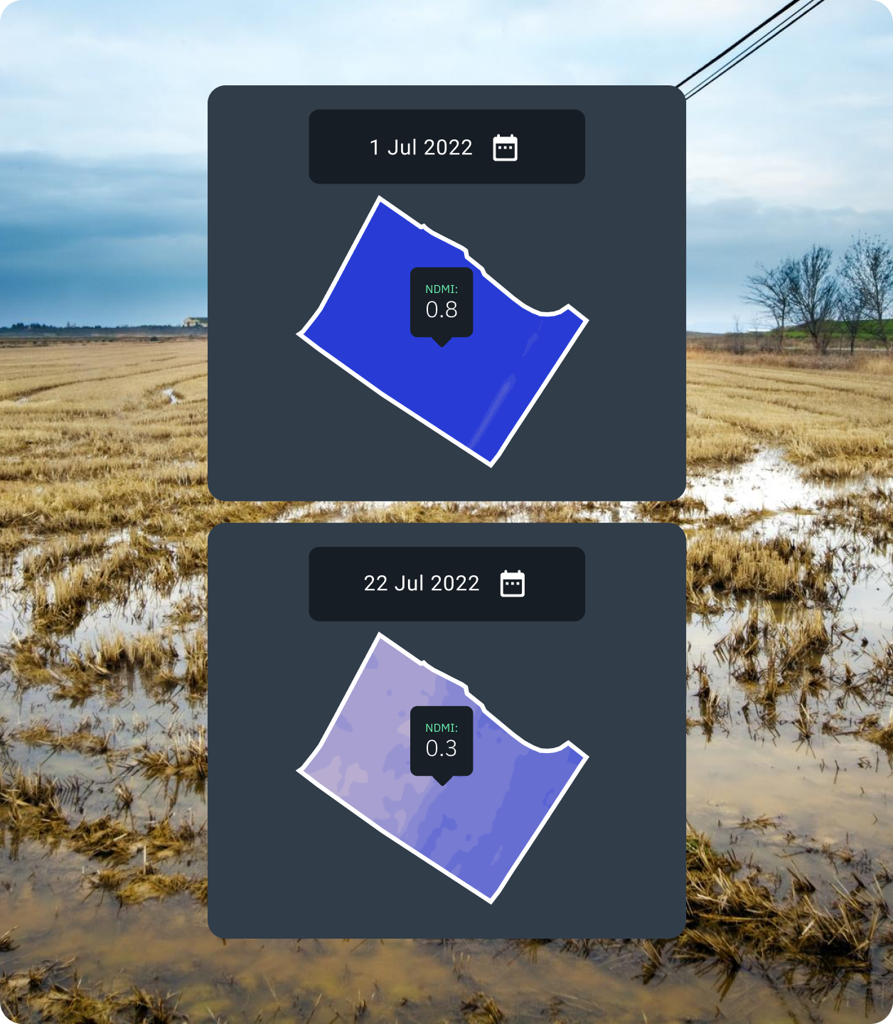
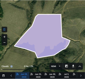
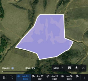
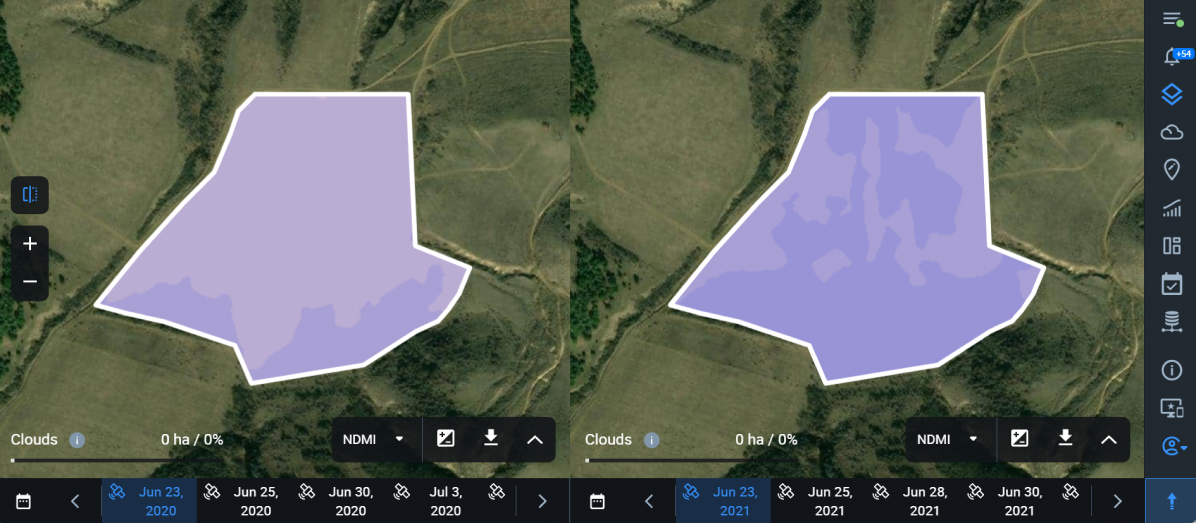
EOSDA Solution For The Georgian Farmers' Association
- Georgia's irrigated lands are shrinking due to climate change, urging farmers to move away from traditional water-intensive farming toward precise irrigation. Moreover, the lack of historical vegetation data from past seasons makes it difficult to locate field issues.
- By utilizing vegetation indices on EOSDA Crop Monitoring, the association compared vegetation and plant moisture values across seasons: before and after they optimized their precise irrigation system.
NDMI map — June 23, 2020 vs June 23, 2021:
BEFORE and AFTER precise irrigation system optimization
NDVI map — June 23, 2020 vs June 23, 2021:
BEFORE and AFTER precise irrigation system optimization
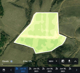
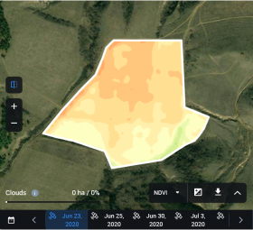
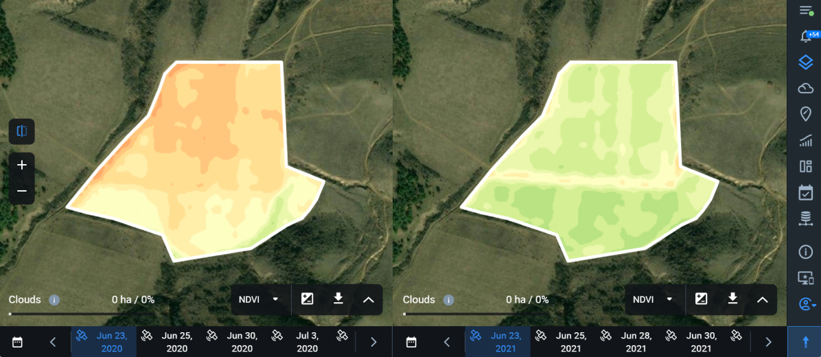
2020's maps highlight areas with low NDMI and NDVI values, indicating a lack of plant moisture and low vegetation accordingly. The decision to optimize irrigation turned out beneficial to crop development and yields as proven by higher NDMI and NDVI values in 2021.
Here's More Client Success Stories and Useful Articles Worth Your Time
Oil Spills In The Amazon: A Never-ending Tragedy
EOS Data Analytics interviewed victims of the 2020 oil spill in Ecuador’s Amazon, monitored the situation around the latest incident, and analyzed satellite imagery to assess the negative impacts of the 2020 spill on the flora of the affected area.
Change And Flood Detection In Northern Kazakhstan
Data scientists at EOS Data Analytics have validated a proof-of-concept project by training a custom neural net for predicting seasonal floods in one of the Kazakhstan regions.
How Gold Mining In Brazil Destroys Local Nature
The Munduruku people in the state of Pará, Brazil, are suffering from the detrimental effects of gold mining that poisons the soil and local rivers. In this case study, EOSDA assessed the scale of the problem from space.
EOSDA Solution Improves Operations In Nature Agency
The Wyoming Game and Fish Department leverages satellite image analytics from EOSDA Crop Monitoring to reduce expenses and save time on scouting and handle crop damage claims more efficiently.