The primary goal of nature conservation agencies is to introduce wildlife management policies that will allow people and wildlife to coexist. Preservation policies include sustainable fishing and hunting, monitoring species and mapping environments they live in.
Data collection based on on-site inspections and research makes a significant part of agency specialists’ duties. Therefore, satellite remote sensing allows nature conservation specialists to access and use relevant information about the state of territories and species while minimizing field activities.
This case study will discuss how the Wyoming Game and Fish Department uses the EOSDA Crop Monitoring precision agriculture platform to coordinate scouting activities and collect relevant data about areas with vegetation issues and their reasons.
The conservation agency uses this data to handle crop damage claims from landowners: conclude which damages it’s responsible for and define the amount of compensation in case of its liability.
Overview: About The Wyoming Game And Fish Department
Founded in 1973, the Wyoming Game and Fish Department is the conservation agency that manages and preserves about 900 species of animals and fish in the state.
The agency’s wildlife conservation activities include enforcing hunting regulations and monitoring and managing game and fish populations, distributions, and habitat. The department is also responsible for watercraft registration and usage and enforces invasive species laws.
The agency consists of three divisions: services, fisheries, and wildlife.
The services division comprising two teams — lands office team and biology survey group — monitors and maintains commission-owned lands for public use, property, and infrastructure (including IT). The specialists sustain wildlife well-being during non-hunting seasons.
The fisheries division monitors habitat areas of aquatic animals, fish health and ensures fish populations are sufficient to avoid their extinction while meeting the anglers’ needs.
The wildlife division provides veterinary and wildlife forensics services, supports the monitoring of game and nongame species statewide to determine their population, conserves ungulate migration corridors, and establishes rules for hunting and and possessing wildlife.
EOSDA Crop Monitoring
Manage your fields with high-resolution satellite images for the most accurate and timely changes detection!
Сhallenge: The Lack Of Personnel And Technology For Implementing A Damage Program
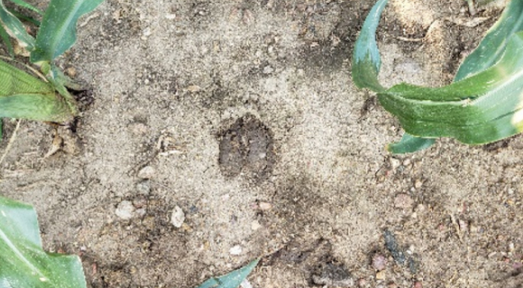
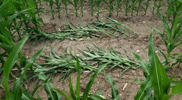
One of the department’s activities is a damage program: reviewing claims from landowners about yield losses and crop damage due to the concentration of wild big game or trophy game animals on ranches and farms. The result of each processed claim is an investigation report that specifies the location of the damaged piece of land and the reason for this damage. Depending on the report details, a landowner claim can be covered entirely, partially, or denied in reimbursement.
Investigation entails scouting, collecting weather data, evaluating crops damaged, and much more. There is the need to differentiate between the damage type (ex. raccoon, elk, deer, pronghorn moose) since the department is responsible for damage done to lands by specific game species. Specialists must also evaluate whether or not the loss is due to mistakes in farmer operations (insufficient irrigation or fertilizer use, equipment failure) or weather extremes like droughts.
The staff has struggled to process the growing number of claims, and claims have become more complicated. The ever-increasing workload and the need for an additional justification for damage claim reports have motivated the department to look for a monitoring system that can automate daily activities and aggregate data from reliable sources, and, importantly, analyze this data.
There are a lot of great satellite data sources for monitoring in Wyoming. But historically, what’s been missing is the analytics.
Solution: The Scouting App And Access To Historical Data For Efficient Damage Claim Processing
The Wyoming Game and Fish Department has augmented their workflow with our solution, an online satellite-based precision agriculture platform for near-real-time crop monitoring.
Employees specify fields with exact areas with vegetation deviations for inspection. Scouts get to the problem areas and classify the damage type, current crop (plant density) and soil condition (moisture). Collected data, such as maps with vegetation issues and photos, supplements investigation reports presented to the department commission and landowners.
The latter handles the appeal process from claimants disagreeing with the agency’s decision.
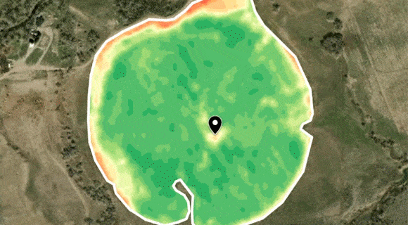
So, using the scouting app within EOSDA Crop Monitoring service, wildlife specialists can respond more quickly to issues knowing where the problem spot is.
It’s a more timely and focused investigation, and it’s more specific to an area. Scouts can go and check an exact spot once they get a notification instead of just trying to take on an entire pivot.
Insights from the scouting app allow the agency to save “some miles of driving” and decrease expenses on gasoline. And since all scouting data is collected and managed in one place, reporting takes less time than before.
The agency also sees the potential of using the EOSDA Crop Monitoring zoning feature to create vegetation and productivity maps. By analyzing current productivity data and comparing it with historical data, wildlife specialists can define field zones with high productivity and suggest landowners to put disclosure cages to prevent crop damages from game animals.
At the same time, it’s possible to specify evacuation zones for big game animals knowing what areas (e.g., field edges) are usually damaged the most.
Outcome: Time And Effort Savings For Handling Damage Claims
The EOSDA Crop Monitoring helps the Wyoming Game and Fish Department make data-driven decisions within the damage program. In particular:
- Obtain and analyze satellite imagery data.
- Accurately and timely define areas with vegetation issues.
- Optimize scouting activities, saving time and effort on unnecessary inspections.
- Classify the reason and type of damage to decide on the landowner claim compensation (full or partial) or payment denial.
The agency specialists keep in touch with EOSDA account managers and consider additional use cases for the platform to optimize their operations further and achieve more savings.
Need a solution tailored to your business goals? Book a call with our team to see how we can help.
Detect crop risks earlier with AI-powered field alerts.

More news
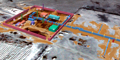
EOSDA tracks construction progress in the UAE PAD areas
Managing rapid industrial expansion in the UAE requires accurate data. See how our satellite-based solution helped a client verify construction milestones and reduce inspection costs.

Validating satellite tech for flood analysis and damage mapping in Coimbra
Can satellites improve disaster response? We explored this in the Coimbra district, showing how integrated satellite intelligence can assess flood impacts and fill critical data gaps during a crisis.

EOSDA advances rice field mapping in Indonesia with SAR
EOSDA tested a radar-based approach to improve rice field detection in Indonesia. By integrating SAR and optical data, the team ensured stable monitoring even during peak monsoon months.