Agriculture Satellite Images To Power Up Daily Crop Tracking
Frequent high-resolution farm satellite imagery gives you the edge needed to manage crops more precisely, efficiently, and confidently. Make informed decisions with current and historical images combined with powerful analysis and forecasting tools, all in one platform:
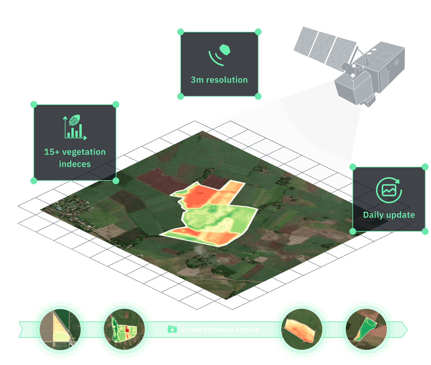
- 3m-resolution images for accurate detection of field anomalies
- Daily updates for cloud-free, consistent imagery
- 15+ vegetation indices to assess the field state
- 5-year archive for field history and trend tracking
Trusted by


How to use high-resolution satellite imaging in agriculture
Monitor crop health state and changes daily with field-level agriculture data
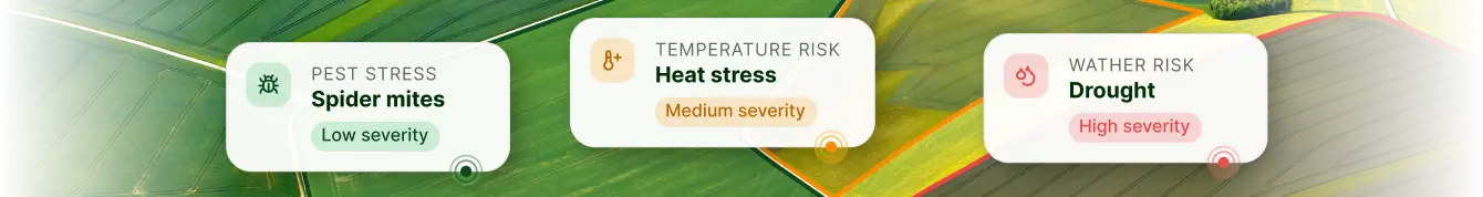
Catch disease, pest, and stress signs with vegetation analysis and risk alerts
Optimize intervention timing by tracking plant growth stages and health issues
Precision agriculture satellite imagery at work on real farms
Satellite imaging agriculture already supports effective crop monitoring in modern farms by showing field-wide health trends. But the real advantage comes with daily, high-resolution satellite data for agriculture. It provides the detail and speed needed to spot trouble early and know exactly where to intervene.
Optimizing agriculture water use based on high-resolution satellite data
With ground-based point measurements, water stress in crops is often overlooked until it causes significant harm. To catch it early, a Chilean agri-tech company turned to high-resolution agriculture images from PlanetScope integrated into the EOSDA Crop Monitoring platform. The team uses NDVI and NDMI to follow crop growth based on the BBCH scale, detect low moisture levels, and identify early signs of water stress. On a regular basis, they review updated agriculture imagery, weather forecasts, and soil data to give clear irrigation advice for each field. Over 80% of their projects now rely on detailed (up to 3m-resolution) satellite images, taken up to four times a day, to guide their irrigation decisions.What the farmer gains:
- Early detection of water-related crop stress
- More precise irrigation timing based on field data
- More efficient water use and improved crop resilience across all monitored fields

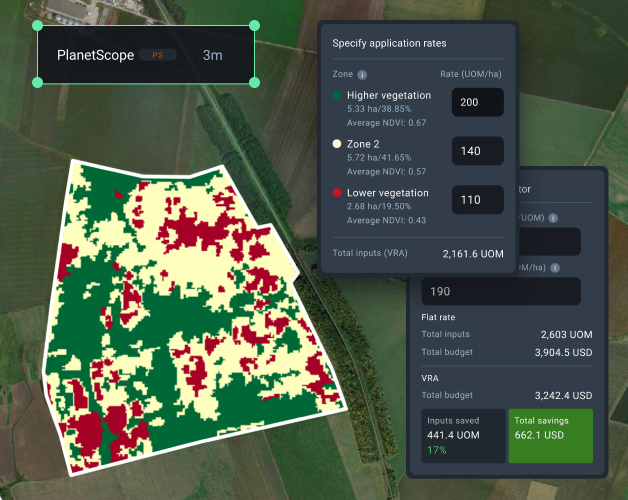
Targeted fertilizer application across large areas with hi-res images
The farm manager overseeing 300 hectares of wheat in Argentina noticed uneven growth across the area but lacked the data to act. Accessing PlanetScope high-resolution images through EOSDA Crop Monitoring changed the game. With our crop growth monitoring system, the team pinpointed low NDVI areas that matched regions with poor nutrient uptake. They used EOSDA's variable rate application (VRA) feature to generate a nitrogen map tailored to each zone. Integrating PlanetScope images into their nitrogen maps allowed for more accurate fertilization and more even crop growth across the field.What the farmer gains:
- Saved 18% on inputs thanks to optimized nitrogen use
- Yield increase by 9% thanks to targeted fertilization
- Full yield potential unlocked in top-performing zones
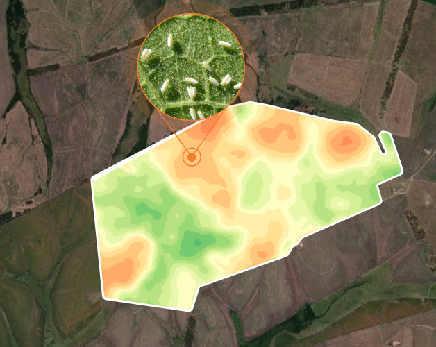
Early pest detection on scattered fields with daily imagery updates
Whiteflies can spread fast in cotton fields. Farmers lacking precise monitoring might end up spraying too late or across entire fields just to be safe. An Indian agronomy consultancy avoided this scenario by using high-resolution satellite imagery and precision agriculture tools of EOSDA Crop Monitoring to track client fields. When vegetation index values dropped slightly in several cotton plots, the system raised a flag. Field scouting confirmed whiteflies were starting to spread. With precise imagery, the consultancy identified specific zones for treatment and helped clients apply insecticides only where necessary.What the farmer gains:
- Pest damage contained
- Spraying area reduced by 60%
- Protected over $150,000 worth of crops
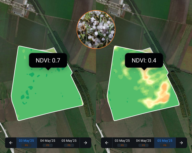
Remote hail damage assessment for insurance claims
After hail struck soybean fields in Iowa, USA, the insurance provider faced a pressing issue: how to evaluate crop damage over large areas without costly and slow on-ground inspections. So, they turned to agriculture mapping software. Using high-resolution PlanetScope imagery along with other EOSDA Crop Monitoring features, the insurer compared NDVI values before and after the event. This lets them remotely assess damage severity, pinpoint total versus partial losses across multiple fields, and rapidly generate detailed reports for claim processing.What the farmer gains:
- Claims processed 3x faster
- Field visits avoided in 80% of cases
- Fair and accurate compensation based on real data
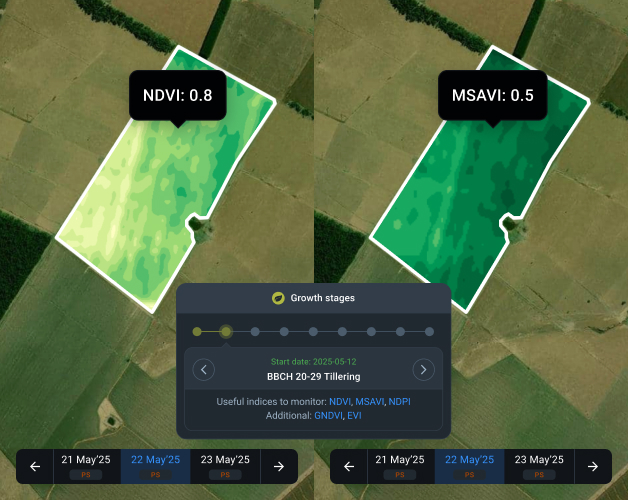
Continuous field health monitoring with NDVI, NDRE, and MSAVI imagery
When managing large soybean fields, missing early crop health issues can cost time and yield. That's why a Brazilian farmer covering 1,500 hectares started using PlanetScope satellite imagery through EOSDA Crop Monitoring. By combining NDVI, NDRE, and MSAVI, they tracked plant growth regularly, detected early nitrogen issues, and found poor-emergence areas affected by soil compaction. Because they have chosen the most relevant indices depending on the crop stage and could benchmark vegetation levels against typical index values, it was easy to spot deviations early.What the farmer gains:
- Detecting and resolving issues about 1 week earlier than before
- Data and analytics for agronomists to give zone-specific recommendations
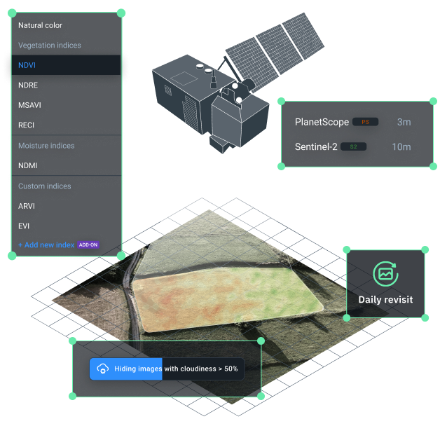
Why check agriculture satellite imagery on EOSDA Crop Monitoring?
Several data sources: Sentinel-2 and PlanetScope
Spatial resolutions for different tasks: 10 m (Sentinel-2) and up to 3m (PlanetScope)
Frequent updates: PlanetScope daily, Sentinel-2 every 3–5 days
Advanced cloud-detection algorithm for clear image results
15+ vegetation indices available for deeper insights
Smooth integration with weather, soil moisture, and other key data sources
Frequently Asked Questions
Satellite Imagery for Agriculture Explained
How does satellite imagery work in agriculture?
Satellite images for agriculture help monitor crop health and growth, as well as field conditions. With vegetation indices, like NDVI, MSAVI, and EVI, applied to these images, you can get even more insights and make data-driven decisions.
What types of satellite imagery are used in precision agriculture?
Multispectral and high-resolution optical imagery is typically used in precision agriculture. This imagery and imagery-based vegetation indices (e.g., NDVI, NDRE) help track crop growth and plan input applications accordingly.
What is the role of NDVI and other indices in satellite imaging for agriculture?
Indices like NDVI, NDRE, and MSAVI are crucial in analyzing satellite imagery for agriculture to assess plant vigor and recognize stress zones. They turn raw imagery into information about crop health and biomass.
How accurate are satellite images for monitoring agricultural land?
Modern agriculture satellite images, with a 3–10 meters per pixel resolution, monitor fields highly precisely. High resolution and frequent updates ensure accurate tracking of changes in vegetation and field conditions.
How often is new satellite imagery available for farms?
New satellite images for agriculture can be available daily, for example, via PlanetScope, or every few days, for example, via Sentinel-2. The EOSDA Crop Monitoring precision agriculture platform automatically updates fields with the latest imagery for near-real-time analysis.
Practical Applications and Benefits
How can satellite imagery improve farm operations?
Satellite imagery provides regular updates on plant health and stress levels. This allows farmers to detect issues like pests, diseases, or water stress early and thus act fast to protect yields.
Can satellite imagery be used to optimize irrigation in agriculture?
Yes, agriculture satellite imagery is widely used to detect water stress and evaluate soil moisture for irrigation planning. Paired with weather data, it enables better timing and use of water across fields.
Is satellite imagery suitable for both small farms and large-scale agriculture companies?
Yes, satellite imagery works well for both small and large farms. Even in areas as small as 5 ha, satellite imagery agriculture supports precise input planning, scouting, and yield estimation. Digital platforms make this technology affordable and accessible, regardless of farm size.