Grapes are a complicated crop type, as they require special consideration on irrigation, disease prevention, and reactive treatment. To grow grapes, water is the most essential resource, which is why winegrowers rely heavily on weather reports, especially in Italy, where precipitation can be unstable and unpredictable. Primo Principio, an Italy-based company, has a model that allows farmers to receive alerts about the water or disease stress in the field, and their irrigation and crop treatment activities largely depend on this system.
However, there is a rising need for a more precise agriculture approach. Farmers require a tool to detect and locate plant stress early and adjust their activities accordingly. With the help of the EOSDA Crop Monitoring platform, Primo Principio strives to excel in the watering and treatment processes of Italian vineyards within its purview.
Overview: About Primo Principio
Primo Principio is an innovative cooperative specializing in sustainable ICT solutions for agro-environmental monitoring and traceability. Leveraging its expertise in sensors and wireless networks, the company offers hardware and software solutions tailored to the agricultural and rural sectors. It provides cost-effective, environmentally friendly wireless solutions to bridge the digital divide in remote and isolated areas. Additionally, the cooperative delivers customized IT services and network solutions for small and medium-sized enterprises, public institutions, and local authorities.
Primo Principio’s expertise lies in designing and developing hardware and software solutions for advanced production process management. These solutions contribute to a more in-depth understanding of environmental and microclimatic conditions in agriculture for crops like wine and olives. Moreover, the cooperative engages in international partnership projects in developing countries, focusing on ICT and water management solutions. As for agricultural projects, the company mainly focuses on provisional modeling. Their most prominent market is Italy, but Primo Principio also has a few clients in Slovenia and Greece.
Primo Principio’s approach is to retrieve the data from an on-location weather station and feed it to their algorithm. This data includes detailed information on temperature, humidity, and precipitation. Subsequently, the model utilizes this information to give actionable insights to its clients, sending alerts through standard channels like WhatsApp or email. Clients are empowered to customize their alarms based on specific factors such as increasing temperatures, pathogen detection, altering precipitation, and more. Essentially, this system serves as customer support for their crops.
Challenge: Timely Irrigation And Pathogen Treatment
In Italy, vineyard farmers depend on weather forecasts to guide decisions regarding irrigation and treatments for their fields. Demonstrating a commitment to client well-being and aiming to streamline and automate their experience, Primo Principio employs a data-driven model to collaborate with viticulturists across the region, delivering precise information derived from on-site weather stations.
The model operates on two critical fronts essential for farmers: irrigation and pathogen detection. The concept is to notify clients of the optimal time for plant watering or applying preventive or responsive treatments. Though the model is operational, and clients trust it, there is room for innovation in heightening data accuracy and developing more comprehensive, user-friendly visuals.
While Primo Principio’s model is based on on-field weather stations to ensure its precision, geo-specific information is not a part of it. Weather data is not accurate enough for the user to understand which part of their field is currently experiencing issues with pests, intense precipitation, or other stress factors. Irrigation and disease prevention treatment require geospatial data to ensure their application is precise.
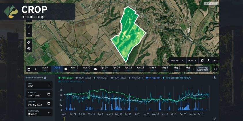
Another challenge with the weather station data is that it lacks presentation and utility. Among Italian farmers, there is a growing requirement to integrate data onto a map, incorporating information on vegetation status calculated through indices like NDVI and NDMI. In such instances, satellite imagery can offer greater precision.
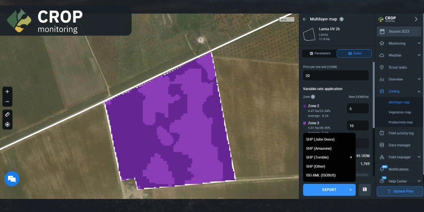
Also, in Italy, special machinery is used for pathogen prevention treatment, a process that can significantly benefit from Variable Rate Application (VRA) maps. These maps, crucial for effective crop monitoring, include vegetation indices and elevation data and are readily accessible through EOSDA Crop Monitoring. Recognizing this potential, Primo Principio decided to investigate whether integrating satellite imagery and monitoring with these VRA maps could substantially enhance the accuracy of liquid spraying.
Solution: Vegetation And Water Indices, Elevation Maps
Primo Principio initiated trials on a few small fields to explore the capabilities of the EOSDA Crop Monitoring solutions. The company received approximately 20 client requests for NDVI maps, reflecting an interest in understanding how these maps could provide additional valuable insights into their fields. To satisfy curiosity and assess the usefulness of the data, Primo Principio began implementing it on field maps across various dimensions, observing how the indices changed based on these variations. During the testing period, those services were free to clients.
While our model generally recommends to clients, “You should water the crops,” the accompanying field map provides additional insight into the optimal location within the field for watering or implementing treatments, particularly when plants are under stress. Currently, these are distinct sets of data that clients can analyze and implement.
The company’s objective for vineyards is to arm farmers and agronomists with what they call “prescription maps.” These detailed maps serve as guides, indicating the optimal timing for crop irrigation, treatments, and other specific field processes. “Prescription maps” are essential tools for precision agriculture, offering farmers crucial vegetation and moisture information to guide their actions. Their incorporation in the process is rooted in the notion that maps enable clients to receive the alert and pinpoint the exact location on the field that requires attention. This approach allows farmers to treat or irrigate specific areas instead of wasting time and resources on dealing with the entire field. The prescription maps can also include historical data if necessary. Satellite data is an excellent solution for the problem at hand, offering more than just visual confirmation for field management through comprehensive maps.
Outcome: More Precise Vineyard Farming
Primo Principio has been using EOSDA Crop Monitoring since May 2023, and the company’s representatives express satisfaction with the platform. There is contemplation within the company about assessing its clients’ successes in the fields after the adoption of EOSDA Crop Monitoring to provide factual information on what changed. Right now, 30 of Primo Principio’s clients are using EOSDA Crop Monitoring, and their field sizes vary from 0.17 to 104 hectares.
At this point, the company provides clients with reports containing maps from EOSDA Crop Monitoring once a week or bi-weekly, tailored to each client’s specific needs. Primo Principio’s managers export the report from the platform, translating the data into Italian before sharing it with customers. Typically, the maps feature layers of the NDVI and occasionally include the NDMI, though sometimes clients’ requests are more sophisticated, so multilayer maps are more valuable. However, the company strives to give farmers more independence while focusing on further innovations rather than routine reporting. This grounds the decision to provide clients with direct access to EOSDA Crop Monitoring.
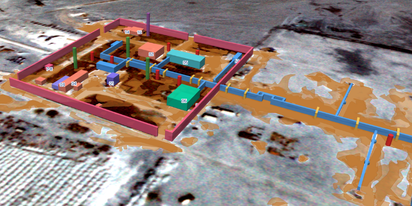
Multilayer maps integrate various data, such as moisture indices, terrain elevation, and vegetation, layered upon one another. These maps empower farmers to apply fertilizers and irrigation with heightened precision, catering to the specific needs of Italian viticulturists. The density and prominence of each layer are customizable and determined by the user-selected percentage during map creation. As users specify the number of zones and detail levels, EOSDA Crop Monitoring precisely analyzes and decomposes specific areas within the chosen field.
Perspectives: Satellite Monitoring For Italian Farmers
Testing the power of satellite technologies, Primo Principio’s clients become increasingly interested in direct access to the platform instead of regular reports generated by it. This way, end users will have the autonomy to determine how many zones they want to divide the area into and which kinds of indices they need for the prescription maps. Additionally, they will be able to access historical data for their analysis.
Primo Principio plans to initiate trial access to EOSDA Crop Monitoring and then gather feedback to see if this is useful for the farmers and agronomists. The company has already prepared a demonstration for the clients showcasing the utilization of NDVI and NDMI on Multilayer maps.
Primo Principio’s next strategic move involves integrating collected data from their model with the insights from EOSDA Crop Monitoring. This initiative will provide farmers with a more comprehensive analysis that combines local weather data with satellite imagery and analytics, facilitating better decision-making in the vineyard sector.
Clients demonstrate a mix of caution and curiosity regarding the technology and its potential utility in field management. The farmers, who are long-time clients, have participated in field trials before, and they’ve seen that the company’s model helps in field management. However, convincing new clients proves to be more challenging. It takes time for them to experiment with Primo Principio’s model, assess the results, and eventually embrace the innovative approach.
The company works tirelessly, enlisting agronomists’ support to present farmers with the benefits of using full data scope for field management.
Need a solution tailored to your business goals? Book a call with our team to see how we can help.
Detect crop risks earlier with AI-powered field alerts.

More news
EOSDA tracks construction progress in the UAE PAD areas
Managing rapid industrial expansion in the UAE requires accurate data. See how our satellite-based solution helped a client verify construction milestones and reduce inspection costs.

Validating satellite tech for flood analysis and damage mapping in Coimbra
Can satellites improve disaster response? We explored this in the Coimbra district, showing how integrated satellite intelligence can assess flood impacts and fill critical data gaps during a crisis.

EOSDA advances rice field mapping in Indonesia with SAR
EOSDA tested a radar-based approach to improve rice field detection in Indonesia. By integrating SAR and optical data, the team ensured stable monitoring even during peak monsoon months.