In an era where the dynamics of agriculture are rapidly changing, the sector faces a myriad of complex challenges. The escalating global population amplifies the demand for food production, while the issue of food security becomes increasingly critical. Moreover, the industry is grappling with the emergence of vascular diseases, including intimidating pathogens such as Fusarium TR4, Moko, and Sigatoka, as well as various pests and illnesses that pose a significant threat to crop health.
In response to these pressing challenges, Dole Asia, with its Dole Future Council, has embarked on a groundbreaking partnership with Agright Technologies, heralding a new era of agri-tech innovation. This collaboration introduces the EOSDA Crop Monitoring platform, a cutting-edge technology that offers comprehensive multilayer and elevation maps, along with ReCl and NDVI indices. These tools enable the precise identification of affected areas and empower the Agronomist champions to formulate targeted strategies for disease mitigation.
Overview: About Dole Asia and Agright Technologies
Dole Fresh Produce, a distinguished division of the globally recognized Dole Asia, stands at the forefront of redefining the agricultural landscape across Asia and the Pacific. Deeply committed to its mission of delivering high-quality, accessible, and nutritious produce, the company leverages over 50 years of experience in banana cultivation and production in the Philippines. More than just a leader in the fruit industry, it acts as a catalyst for innovation and the advancement of the agricultural landscape.
Philippine-based, Agright Technologies elevates Dole Asia’s strategic agricultural approach through its purposeful application of the 4R framework, emphasizing regenerative, restorative, resource-efficient, and resilient agricultural practices. This approach is not about direct management of cultivation, but about providing a suite of agtech solutions and contract research services tailored to meet Dole Asia’s specific challenges. Agright’s contribution is deeply technical, focusing on integrating cutting-edge technologies and data-driven insights. This partnership is characterized by a shared commitment to sustainability, with Agright’s endeavors aimed at reducing environmental impact, enhancing soil health, and ensuring the long-term viability of farming operations. The technical value of the company lies in its ability to transform conventional farming systems through the application of science and technology, thereby setting new benchmarks for the industry and contributing to a more sustainable and resilient agricultural future.
The strategic alliance between Dole Asia and Agright Technologies signifies a monumental leap forward in combating agricultural adversities. By harnessing the power of advanced agri-tech solutions, they are establishing new standards for sustainability and efficiency in farming practices. This partnership not only ensures the continued provision of bananas as a vital source of nourishment for future generations but also exemplifies a steadfast commitment to innovation and collaboration. Hand in hand, they are not just addressing the challenges of today but are also sculpting the future of agriculture.
Challenge: Confronting The Fungus Crisis In Banana Production
In the Philippines and the world’s banana belt, this industry is facing a huge challenge that could change everything we know about our favorite fruit. Vascular disease is caused by harmful pathogens that attack the banana plants from the inside, making it difficult for the plants to stay healthy and produce fruit. Among these pathogens, fungi, especially one known as Fusarium, particularly the strain known as Tropical Race 4 (TR4), are the main culprits. Fusarium TR4 is particularly alarming because it’s spreading quickly in the Philippines, Cambodia, and China, and as of now, there is no known cure. This situation puts farmers in a tough spot, trying to save their crops and income. This challenge is not just about bananas. It is about ensuring food security and supporting livelihoods in the face of a growing threat.
The banana industry worldwide is grappling with the pressing challenge posed by Fusarium wilt, which has caused widespread devastation in banana plantations globally. This pathogen has been documented to wreak havoc across continents, leading to significant agricultural and economic losses.
In the Philippines, the situation is particularly dire. Agright Technologies, which initially oversaw approximately 10,000 hectares of banana farms, has observed up to 20 to 40% of affected areas attributed directly to the relentless spread of TR4. In response to the global and local devastation caused by TR4, Agright has opted for a novel approach. The company aims to coexist with Fusarium TR4 and other pathogens. Embracing the principles of biodiversity and the 4R framework, Agright believes in leveraging the natural strengths of diverse agroecosystems to overcome pathogenic threats. A foundation of this strategy is the early detection and diagnosis of TR4, allowing for the implementation of agile agronomic actions based on data-driven insights. This approach represents a paradigm shift towards living in harmony with potential threats by enhancing the overall resilience and health of banana plantations.
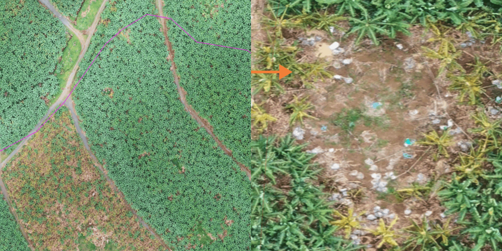
Agright Technologies employed visual identification, primarily through drone images. However, despite their effectiveness, drones pose challenges due to their high cost and scarce image frequency. The operational concept for Agright Technologies involved flying drones at an elevation of approximately 60–70 meters, capturing photos every 25 meters. If the plantation was large enough, spanning around 50 hectares, a drone had to capture 1,000–1,200 photos, later stitched together to provide comprehensive imagery. Elevation, in this case, played an interrupting role, as the person flying the drone constantly had to change its heights due to uneven and irregular surfaces. That added to the overall costs of the images. Therefore, it was a challenge to capture the disease spread and react to it in a timely manner before the loss of the entire crop.
Solution: Transforming Plantation Care With Satellite Insights
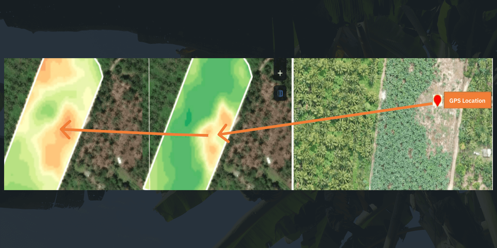
Agright Technologies embraced the cutting-edge power of satellite imagery analytics through the digital agriculture platform. This transformational move has empowered agri companies to precisely monitor crop health conditions and disease spread across their operations, including Dole Fresh Produce group’s banana plantations both in the Philippines and Sri Lanka. By meticulously monitoring over 10,000 distinct farms, Agright Technologies leverages EOSDA’s global perspective to gain critical insights into disease dynamics, enabling proactive and targeted interventions.
The data speaks for itself, as it is witnessed in the plantations in Mindanao island in the Philippines, showcasing how satellite analytics can guide strategic decisions and optimize actionable and pragmatic solutions for significant agricultural outcomes. EOSDA Crop Monitoring emerges as a key enabler in this innovative journey, offering Agright Technologies a powerful tool to enhance multifactorial insights relevant to plantation resilience and productivity.
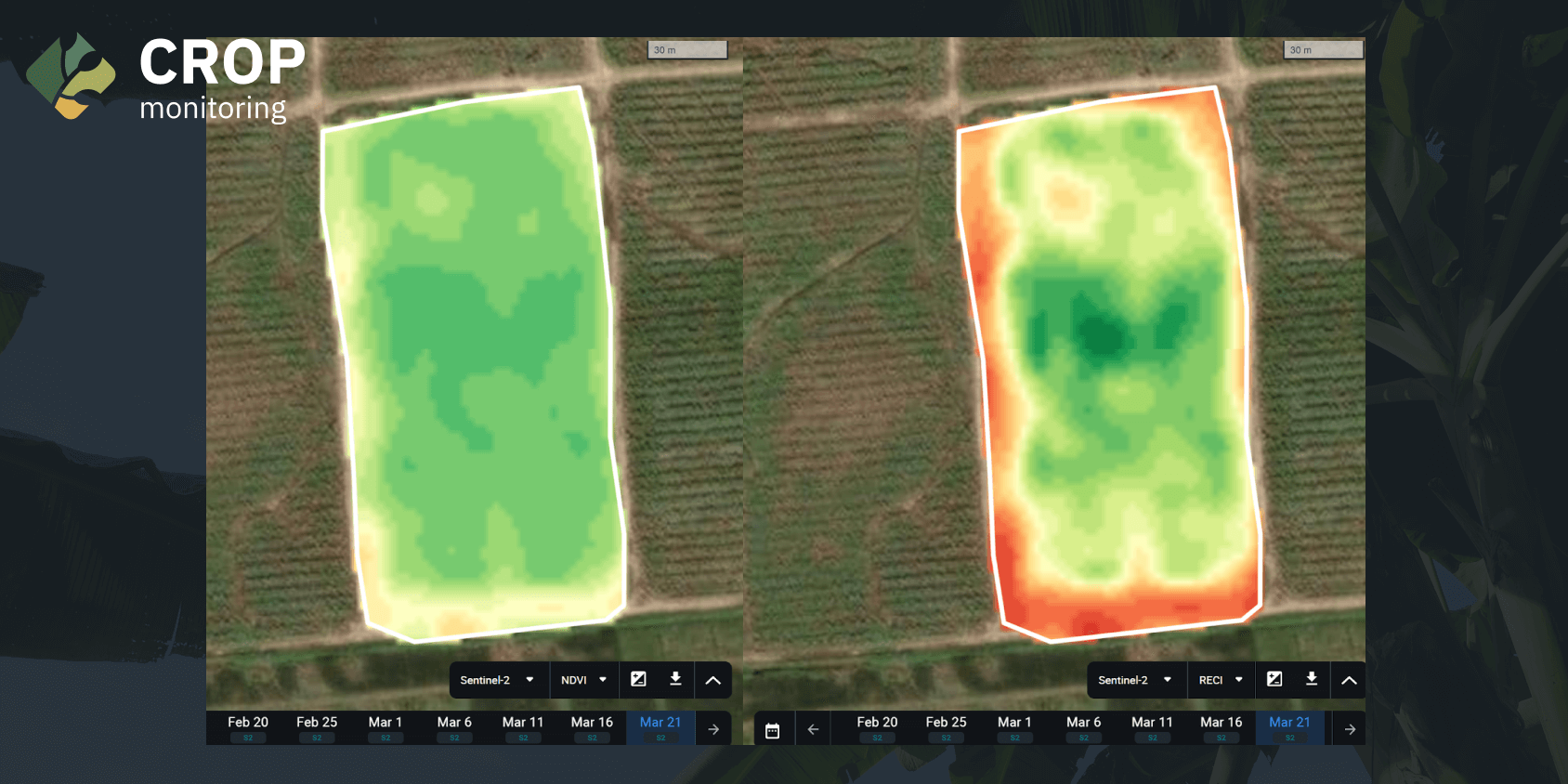
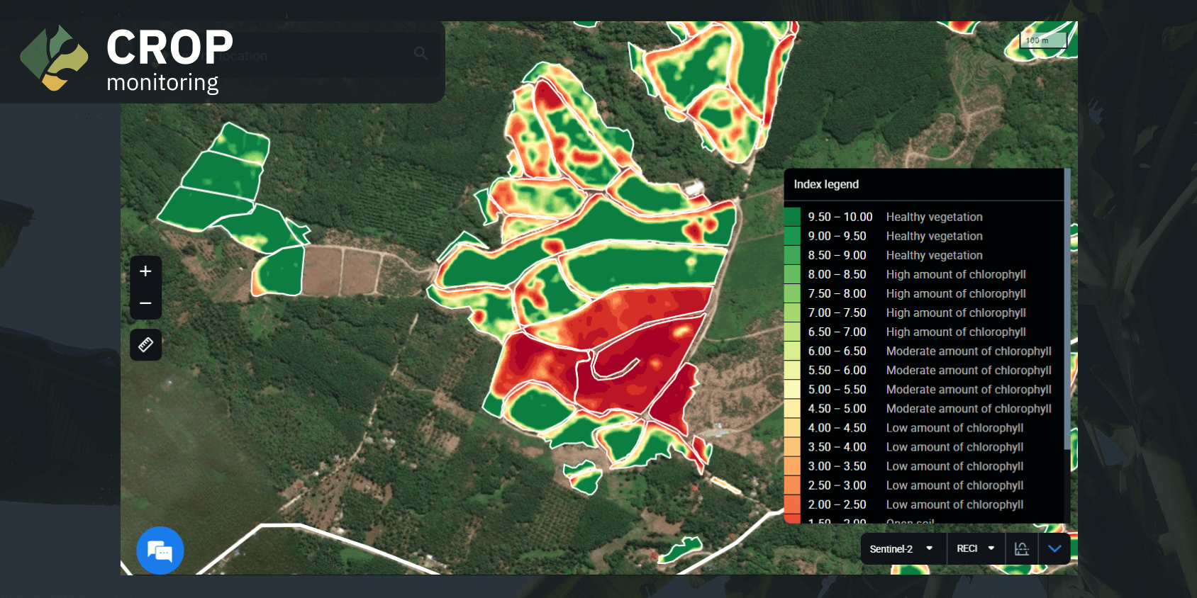
The map of a farm in Central Mindanao, Philippines, depicted above utilizes the ReCl (Red-edge Chlorophyll Index) to indicate the chlorophyll levels in plants. Insufficient chlorophyll suggests that plants may not be considered healthy, indicating potential illness. Notably, there are prominent red zones in the image above, highlighting areas that require closer examination. Subsequently, professionals at Agright Technologies assess the density of plant coverage on the land.
Managing and collecting data on numerous small individual farms, each ranging from 1 to 1.1 hectares, poses challenges. In a vast expanse of 10,000 hectares, distinguishing and evaluating the percentage of chlorophyll content on a 1-hectare scale becomes complex. To determine the extent of infection, Agright Technologies used to rely on counting infected areas based on farm numbers. Luckily, with EOSDA Crop Monitoring, ReCl reveals areas or entire fields that require immediate abandonment. A swift report translates to a prompt response. The findings from the platform enable Agright and, therefore, farmers to stop investing resources in nurturing “lost causes” and identify plantations in need of rest. Additionally, companies recognize the risk to areas close to infected fields, aiding in the strategic decision of which plots to abandon next.
Agright Technologies provides detailed reports with insights to Dole Future Council, facilitating assessment and decisive actions. EOSDA Crop Monitoring serves as a collaborative tool, offering both companies a comprehensive understanding of the overall situation on the plantations. Companies can strategically plan their upcoming work based on the initial infected area and the expected spread until the end of the season. In this manner, EOSDA Crop Monitoring aids in those operations in unaffected or currently unused areas, mitigating the spread of the disease to future crops.
EOSDA Crop Monitoring is revolutionizing agriculture by letting the data speak for itself, transforming satellite imagery into actionable insights for crop health and environmental conditions. Agrights’ cooperation with EOSDA exemplifies this revolution, enabling us to define, develop, and deliver on-point, data-driven solutions to our partners. The platform’s clarity and accuracy have been crucial, earning our trust as a game-changer in agricultural innovation.
EOSDA Crop Monitoring provides NDVI (Normalized Difference Vegetation Index) and ReCl maps. These indices serve to monitor the farm conditions and determine whether the land requires a rest period. The quarantine process unfolds as follows: when a potentially infected farm is identified, dedicated personnel visit the location to validate the accuracy of the satellite imagery analytics. If the farm is indeed infected, isolation measures are implemented, including installing a fence and biosecurity measures to safeguard the surrounding healthy fields. This strategic approach ensures that the unaffected fields remain productive, allowing farmers to recover harvests from those areas.
Amidst the challenges, there is a glimmer of hope, as specific plots exhibit resilience and co-exist with the pathogens. EOSDA Crop Monitoring assists Agright Technologies in identifying areas that remain healthy despite the disease affecting neighboring plots. Crops from these resilient areas become a source of produce, having withstood the fungal infection. These plots help farmers to minimize financial losses and provide a tangible outcome. The ReCl on the EOSDA Crop Monitoring map delineates which plots can still yield valuable crops and identifies those that should undergo quarantine.
Enhancing Rice Farming: Agright’s Terrain Optimization With EOSDA Maps
Satisfied with the efficiency of elevation maps in EOSDA Crop Monitoring, Agright Technologies also employs them for its 50-hectare rice farms, including the Department of Agriculture’s Organic rice demo lot. Rice cultivation is mainly influenced by the elevation of the plot, and studies indicate that it grows poorly in areas with a lack of wate . Agright Technologies corroborates these findings in its rice fields. In light of the insights gained from EOSDA Crop Monitoring, the company is considering flattening out the terrain in the upcoming season. Therefore, EOSDA delivers valuable insights into vegetation, plant moisture content, and chlorophyll levels to a very important staple in Asia — rice.

Outcome: Quarantined Farms, Better Irrigation Systems
After integrating EOSDA Crop Monitoring, Agright Technologies found satellite technology to be a more cost-effective choice than drones. Drone footage proves both expensive and time consuming, including the post-processing phase. Therefore, EOSDA Crop Monitoring’s satellite imagery analytics save costs and streamline the monitoring process by replacing the need for drone imagery by at least 50%.
In addition, the EOSDA Crop Monitoring insights find another valuable application in providing irrigation recommendations. Varied ground types require diverse irrigation methods. Sandy areas, for instance, benefit from sprinkler-type irrigation, while clay-rich soils are better served by drip watering. The soil classification component plays a crucial role in determining the appropriate approach. Elevation maps also play a crucial role when considering watering methods and volumes. Agright Technologies leverages those maps within EOSDA Crop Monitoring to gain insights into different-level areas. Satellite imagery and analytics offer precise data on the ground level of each plot, aiding in informed irrigation decisions.
In 2024, Agright Technologies’ plans include experimenting with using multilayer and elevation maps to explore potential correlations between soil type and elevation. It will allow Agright’s partner companies to determine whether such insights can enhance the precision of the irrigation system design. Elevation maps assess whether a field’s location or soil composition, be it sandy or clayey, influences its water requirements. There is even the prospect of implementing varied watering systems in larger plots in distinct areas. Agright Technologies is eager to leverage EOSDA Crop Monitoring insights to design irrigation systems tailored to their specific needs.
As Fusarium disease spreads across the Philippines, Agright Technologies works tirelessly to maintain healthy banana crops for Dole Asia. Cutting-edge solutions like EOSDA Crop Monitoring deliver comprehensive data to help the company save costs and play a crucial role in preventing the spread of fungi and pathogens in the critical stage of diagnostics and early detection. By promptly understanding the factors influencing their crops, both companies can contribute to sustainable food production on a global scale. Harnessing agricultural satellites is crucial, as they act as an influential catalyst that empowers farmers with up-to-date data and valuable insights, facilitating the optimization of crop yields, risk mitigation, and promoting sustainable agricultural practices.
This strategic collaboration with EOSDA Crop Monitoring positions Agright Technologies at the forefront of agricultural innovation, demonstrating a commitment to utilizing technology for sustainable and efficient crop management. Collaborating with Agright Technologies and tapping into the capabilities of EOSDA Crop Monitoring offers a promising path toward overcoming agricultural challenges and securing the future of food production.
Need a solution tailored to your business goals? Book a call with our team to see how we can help.

Detect crop risks earlier with AI-powered field alerts.

More news
EOSDA tracks construction progress in the UAE PAD areas
Managing rapid industrial expansion in the UAE requires accurate data. See how our satellite-based solution helped a client verify construction milestones and reduce inspection costs.

Validating satellite tech for flood analysis and damage mapping in Coimbra
Can satellites improve disaster response? We explored this in the Coimbra district, showing how integrated satellite intelligence can assess flood impacts and fill critical data gaps during a crisis.

EOSDA advances rice field mapping in Indonesia with SAR
EOSDA tested a radar-based approach to improve rice field detection in Indonesia. By integrating SAR and optical data, the team ensured stable monitoring even during peak monsoon months.