The 2026 storms and floods in the Coimbra district highlighted the limitations of traditional monitoring technologies. Ground teams could not reach flooded areas, and aircraft was grounded by high winds and rain. EOSDA used a mix of SAR and optical satellite data to show that these technologies can bypass weather limitations to analyze flood extent and identify specific infrastructure damage.
Case Highlights
Challenge
Record-breaking storms and heavy cloud cover in Coimbra made it impossible for ground teams and drones to map flood damage accurately.
Solution
EOS Data Analytics used a multi-sensor approach, combining SAR (radar) to monitor flood extent through clouds and optical imagery to pinpoint infrastructure damage.
Outcome
The study provided a clear view of the Mondego River overflow and verified structural damage to specific roads and facilities, offering a scalable framework for governments to prioritize emergency logistics and repairs.
Overview: Local context and the 2026 flood crisis in Coimbra
The Coimbra district sits on the low-relief Mondego valley, which makes it vulnerable to riverine flooding during the wet winter months. Usually, the region manages up to 115 mm of monthly winter rain , but cumulative totals in late 2025 drastically reduced the soil’s ability to absorb water. By early 2026, the basin was fully saturated and unable to handle further downpours.
A sequence of storms — Kristin and Leonardo — brought extreme precipitation and record-breaking winds in early 2026. These storms occurred back-to-back, leaving no time for water levels to recede. The cumulative rainfall reached a record 1,238 mm, a figure that surpassed the historic 1966 floods and put immense pressure on the region’s river defenses .
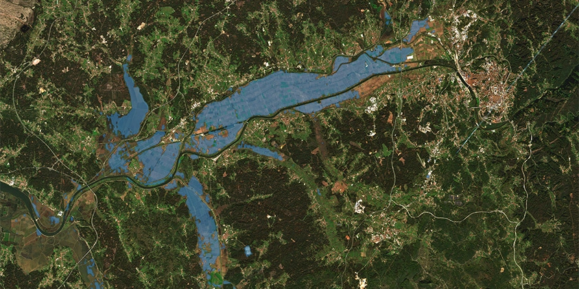
The floods peaked in February 2026 when the Mondego River overflowed, rupturing dikes and submerging farmlands and ancient city walls. Key transport routes like the A1 highway collapsed, and entire neighborhoods, including São Martinho do Bispo, were forced to evacuate. The event caused over 15 deaths and billions in damages, marking a major failure of existing flood control systems.
Challenge: Limitations of traditional monitoring tools
Storms in early 2026 put Coimbra’s traditional monitoring tools to the test and highlighted their limitations:
-
- On-site sensors, such as rain stations and river gauges, are scattered too sparsely across the Mondego basin to track how water moves across the lands.
- Physical inspections proved equally impractical as the infrastructure collapsed. With the A1 and other main roads blocked by debris and water, ground teams could not safely reach Penela or the surrounding districts.
- Drones and traditional aircraft were grounded by the same poor weather they were meant to observe. Low visibility and persistent cloud cover during the winter storms made it nearly impossible for standard aerial photography to document the submerged buildings or eroded farmlands.
This meant that any data collected via traditional monitoring was limited to small, accessible spots rather than the hundreds of square kilometers actually affected.
Space-based monitoring fills this void, though the best results require using more than one type of sensor. Optical sensors provide excellent visual detail of property damage and soil erosion, yet they can’t penetrate through the thick cloud cover common in Portuguese winters. Radar (SAR) sensors can see through these clouds and operate at night, but they can struggle with speckle noise and fine urban details. By integrating SAR and optical imagery, we can overcome local constraints and sensor limitations to deliver a complete, basin-wide analysis of the storm’s impact.
Solution: Multi-sensor satellite monitoring tools
To assess the impact of the early 2026 storms in the Coimbra district, we combined high-resolution optical imagery with Synthetic Aperture Radar (SAR) data. The goal was to demonstrate the potential of using complementary optical and radar sensors to rapidly assess disaster impacts across the region. While radar captured the peak of the floods through heavy clouds, high-resolution optical data provided the fine details of structural damage once the skies cleared.
We wanted to see how far we could push the technology to assess storm impacts. Our findings confirm that combining different satellite sensors lets you move very quickly from broad observations to pinpointing damage, which is a massive advantage when ground resources are limited.
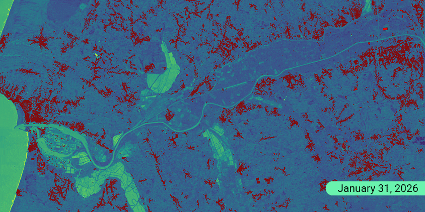
The methodology relied on a diverse set of satellite resources to ensure coverage despite the difficult weather conditions. Sentinel-1 SAR imagery was essential for monitoring the Mondego River overflow in February 2026. Since SAR can see through dense clouds and operates at night, it provided a clear map of water extent when poor visibility limited the use of optical sensors.


Sentinel-2 optical images were used to calculate the NDWI (Normalized Difference Water Index) on clearer days. This helped delineate saturated soil and standing water within residential zones by comparing pre-storm landscapes with the February 22 inundation.
We also used high-resolution 3 m multispectral and 1.5 m panchromatic images by EOS SAT-1 and 0.3 m imagery by BJ3N to zoom in on specific structures. Panchromatic images allowed for the detection of roof deformations, collapsed outbuildings, and damaged road networks that are invisible on lower-resolution maps. Multispectral images helped delineate floodwater, saturated soil, and vegetation, confirming standing water within residential areas.
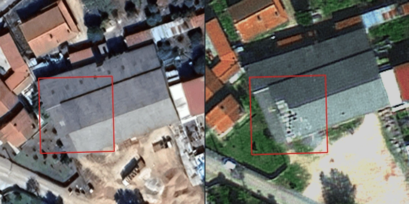
The process also involved cross-referencing satellite findings with crowdsourced data and public reports. For instance, after detecting structural changes in Penela, we integrated media reports about the Fire Station to verify the scale of losses. This ensured that the digital analysis aligned with the reality on the ground.
Outcome: Proven framework for damage verification and disaster recovery
The results of this study demonstrate how multi-sensor satellite data can become a source of truth for emergency response and high-stakes decision-making. In the Coimbra district, we’ve managed to capture the dynamics of the disaster from the initial river overflow to the specific building damage. This capability ensures that even if traditional methods fail, governments and businesses can still get a clear picture of the damage.
The value of our multi-sensor analytical methodology lies in:
-
- Global scalability. This workflow can be applied to any territory, even allowing international organizations to monitor cross-border flooding or infrastructure damage.
- Infrastructure prioritization. Governments can instantly identify isolated residential zones and blocked access routes to coordinate emergency logistics.
- Rapid loss assessment. High-resolution damage checks allow insurers to verify claims for industrial roof collapses and equipment loss within days.
- Enhanced public safety. Verifying the status of emergency hubs, like the Penela Fire Station, helps authorities understand the true state of local response capabilities.
Ultimately, this case study provides a blueprint for modern disaster recovery. It demonstrates that satellite data is no longer just a research tool but a commercial and governmental necessity for protecting assets and lives.
Turn high-tech satellite data into actionable solutions for your business.
More news

EOSDA tracks construction progress in the UAE PAD areas
Managing rapid industrial expansion in the UAE requires accurate data. See how our satellite-based solution helped a client verify construction milestones and reduce inspection costs.

EOSDA advances rice field mapping in Indonesia with SAR
EOSDA tested a radar-based approach to improve rice field detection in Indonesia. By integrating SAR and optical data, the team ensured stable monitoring even during peak monsoon months.
EOSDA Forecasts Yields For 2025 In Saskatchewan
EOSDA created RM-level crop yield forecasts for Saskatchewan to address limitations of official data. The project shows how satellite and weather inputs reveal local yield changes during the season.