Satellite monitoring for agriculture businesses
Unlock a bigger picture of your fields through agriculture monitoring from space. Track vegetation in multiple fields at once, detect threats ahead of major damage, and excel in planning farm activities — all for the sake of bountiful harvests.

Benefits of utilizing remote farm monitoring services by EOSDA
Ready-to-use vegetation indices for smarter agriculture decision-making
More efficient utilization of resources
Scalable analysis of field productivity, from region to globe
Coverage of remote hard-to-reach farms
Early alerts for potential crop health issues
Space-based farm observations on EOSDA Crop Monitoring enable:
-
Insight into the state of your agriculture fields then and now
Access a treasure trove of regularly updated and historical observations of vegetation (5-6 years back) and weather (back to 1979) in your agriculture fields. With our farm monitoring system, nothing will slip under your radar.
-
Collection and analysis of agricultural data
Conveniently keep all your agriculture data on EOSDA Crop Monitoring for instant access and comprehensive analysis. With field history, weather data, and satellite analytics at your fingertips, you'll be equipped to make better decisions and boost farm profits.
-
Satellite-based remote farm monitoring
Keep boots off the ground and let the satellites watch over hard-to-reach farms for you. EOSDA's platform secures a 93% global coverage so you could spot vegetation changes and identify crop growth trends from the comfort of your office.
-
Seamless integration
Integrate our agriculture monitoring system into existing workflow in a breeze. Intuitive interface, role-based access, and downloadable reports ensure convenient data-sharing within teams.
-
Early detection of critical changes
Power up your crop protection with satellite-based agriculture tracking. Our platform sends early alerts for any abnormal vegetation changes enabling timely action to prevent crop failure.
Functionality of EOSDA's remote agriculture monitoring software
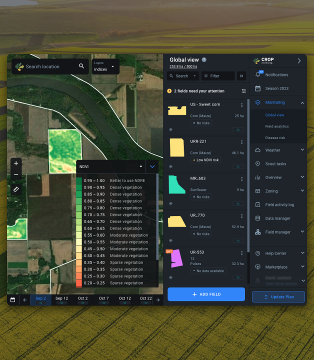
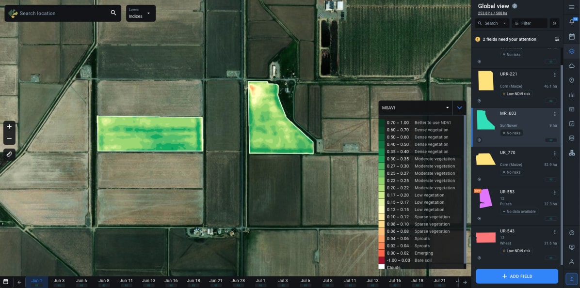
Global View
Get an overhead perspective of your farm for a basic understanding of plant conditions with Global View or dive deep into Field Analytics for granular agriculture insights. Even with a hundred plots on your Field List, you can quickly find your way around with the help of filters. They're particularly helpful for prioritizing high-risk agriculture fields where immediate action might be needed.
Vegetation Monitoring with Satellite Indices
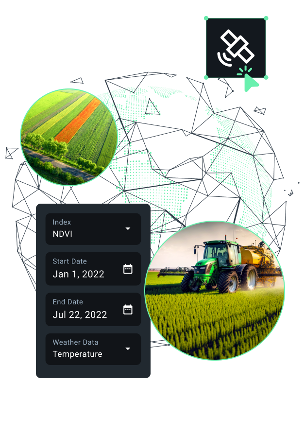
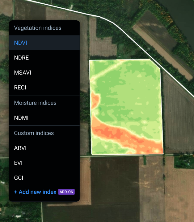
EOSDA Crop Monitoring serves a selection of the most widely used vegetation indices (NDVI, NDRE, MSAVI, ReCl) and a moisture index (NDMI), each proving more insightful than the other at a specific plant growth stage. Want to dig deeper? Opt for an add-on expanding your toolkit with ARVI, EVI, GCI, GNDVI, PSRI, RENDVI, and SIPI, or let our R&D team craft a custom index catering to your specific farm needs.
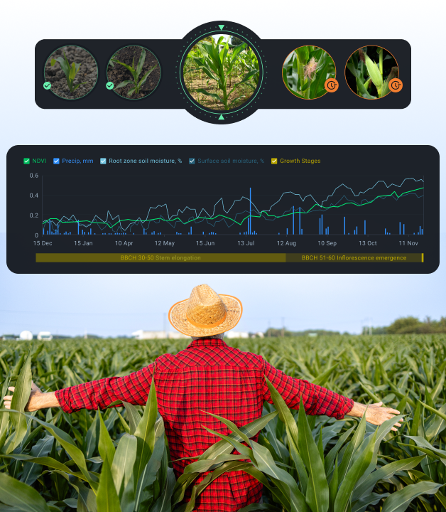
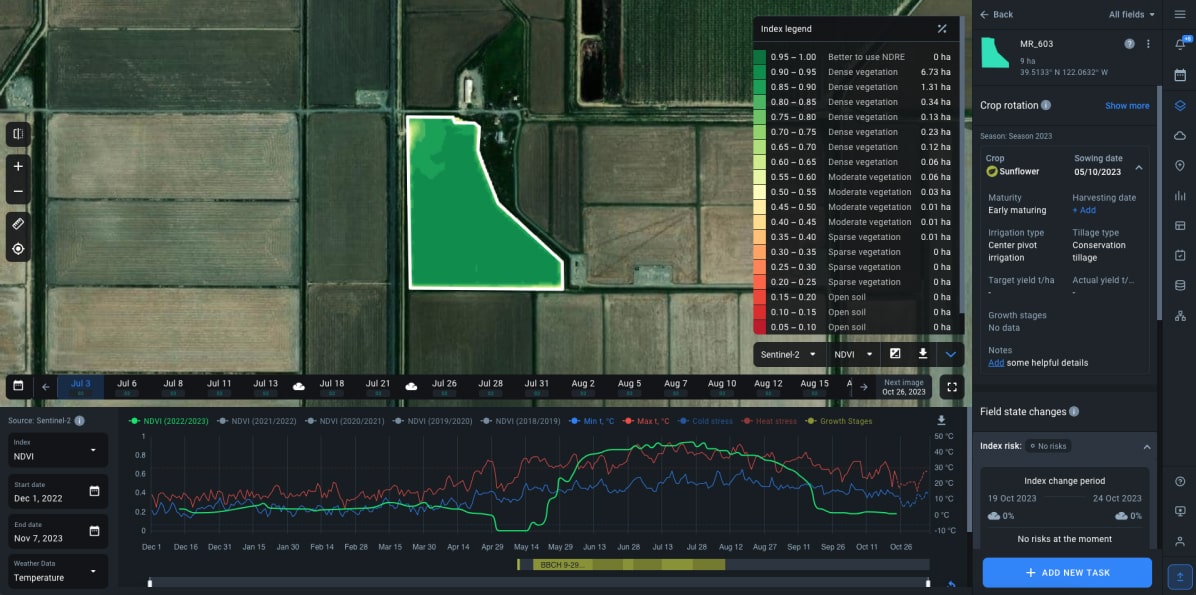
Growth Stages
Track growth stages of your crops based on the uniform BBCH scale to maintain high yields. By looking at a single chart with all important agriculture data (including vegetation indices and field weather), you can see if plants perform as planned and, if not, schedule interventions to fulfill their needs for water, nutrients, or protection against pests and diseases.
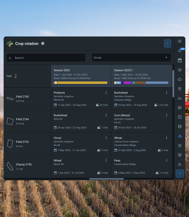
Crop Rotation
To rotate crops or not to rotate? With our satellite-based agriculture monitoring platform, you'll switch from wondering to working out an optimal crop rotation plan. Keep detailed records of crop types, ripeness, sowing and harvesting dates, tillage and irrigation types for each field and season. Probe into crop rotation history to decide what to grow next and plan future sowing to keep your fields fertile and harvests abundant.
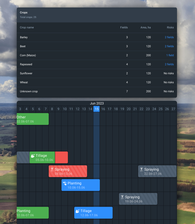
Season Management and Analytics
Manage field activities like a pro, focusing on the seasonality of crops in particular climates and hemisphere. By creating Seasons and linking them with fields, you can sync all relevant agriculture data across growing seasons. What's more, the Season Analytics dashboard provides insight into how your crops and fields perform, enabling on-the-spot improvements. The analytics feature is available for PRO fields in past and current seasons.
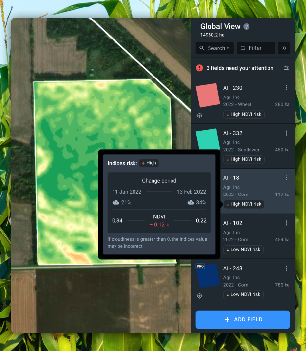
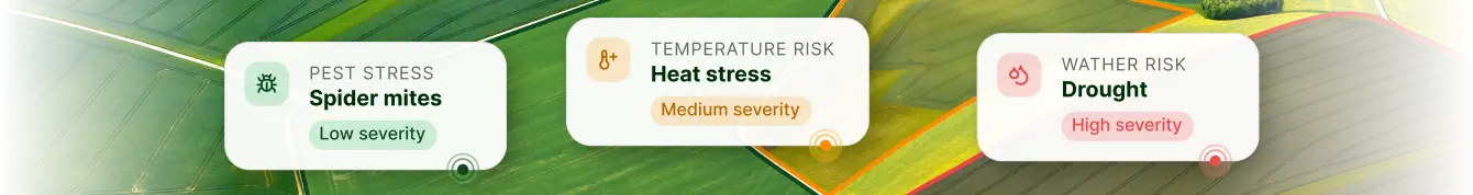
Critical Index Change and Disease Risk Detection
Stay one step ahead of diseases by monitoring crops' well-being through our satellite technology and in-built prediction model. Our farm monitoring platform keeps guard over your plants' health, processing a wealth of data to detect conditions signaling an issue and alert you. By filtering your Field List to see plots with risk alerts on top, you can swiftly jump into action: dispatch a scout or schedule spraying.
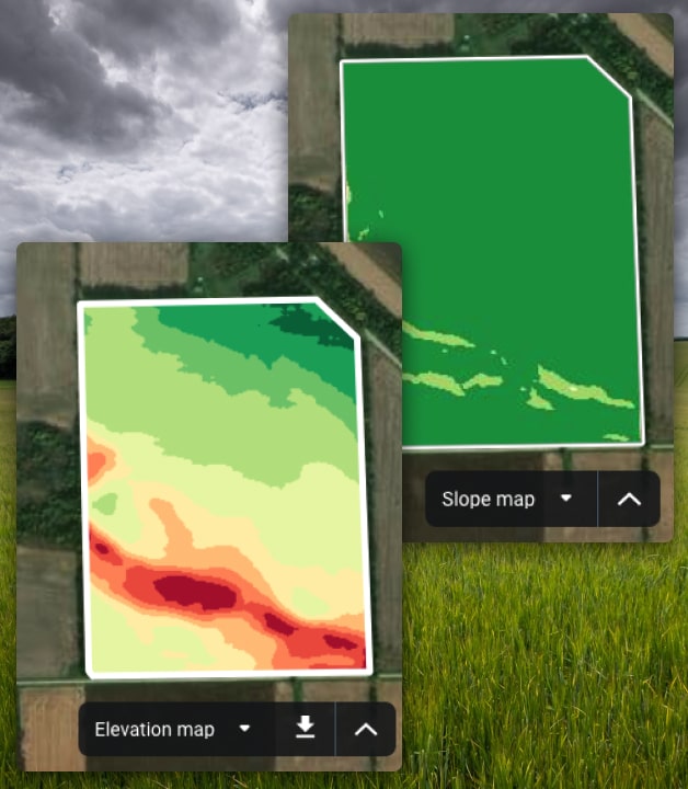
Elevation and Slope Maps
Terrain relief can play against your plans by impeding crop growth and agriculture machinery passes. Make every slope and pit work to your benefit, leveraging our Elevation map (shows the height of any given point above sea level) and Slope map (shows how elevation varies within croplands) for agricultural monitoring.
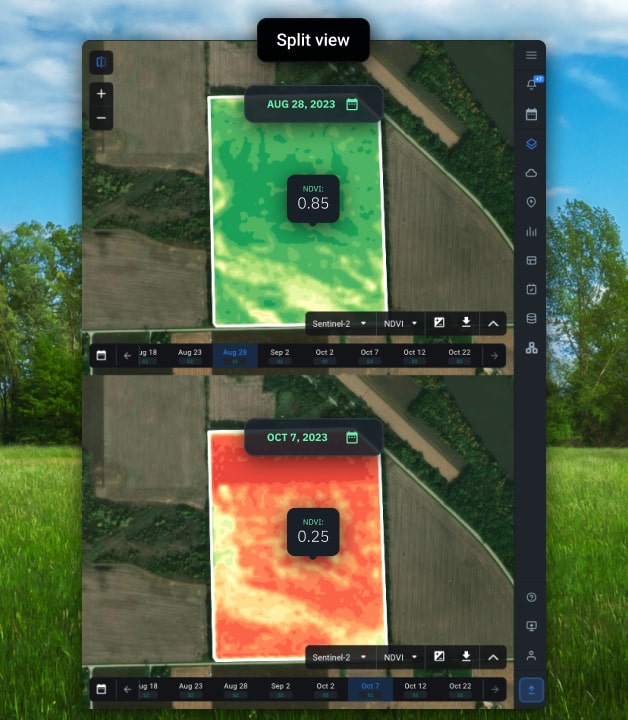
Split View
A side-by-side comparison of various agriculture monitoring data layers — such as space-derived imagery, vegetation indices, Elevation map, or Slope map — can get you to the root of both crop failure and lush growth. Split View is a great tool for unveiling hidden relationships and gaining deeper insight into croplands.
Add-ons on request
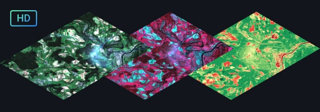
High-resolution satellite imagery
Zoom in on fields with a more powerful source of satellite images for agriculture monitoring — PlanetScope, offering multispectral data of 3-m/pixel resolution. By leveraging daily revisits and high level of detail, you'll spot issues at the earliest, optimize farm activities, and discover previously unseen trends.
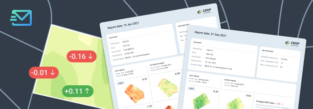
Weekly index change reports
Using satellite data for large scale agricuture monitoring and worried you may overlook a serious crop issue? Receive Weekly Reports detailing every vegetation index drop or spike in the past 7 days alongside weekly precipitation, min and max temperatures. Be the first to know of farm threats, be they water stress or pest attack!
Custom farm monitoring solutions
Our suite of remote monitoring services tailored for agriculture encompasses a wide range of AI-powered solutions to help you meet your business goals.


Empowering agriculture consulting through satellite monitoring
Our client is a California-based agriculture consulting company that helps farmers maximize their yields per acre through expert advice. To deliver on this mission, the team requires frequent updates on vegetation status for detecting crop threats.
- Monitoring of farms using a traditional boots-on-the-ground method proved expensive and inefficient. A small team of scouts often spotted crop issues too late due to the low frequency of field visits (once every 3-4 weeks).
- Agriculture consultants integrated our smart farm monitoring system to watch over sunflower fields a month after the sowing. The satellite data analysis based on MSAVI revealed an area in the MR_603 field with abnormally low vegetation, urging a detailed on-site inspection. Upon arrival at the problem spot, scouts saw a population of cutworms and advised to treat it with pesticides. This helped to stop the spread of pests and minimize crop damage. As seen from the image taken a month later, the affected plants resumed growth at a slightly slower pace compared to the rest of the farmland.
Fresh satellite imagery of fields on EOSDA Crop Monitoring platform comes in every 3-4 days, allowing for nearly uninterrupted vegetation monitoring through our software. Thanks to remote detection of crop issues, scouts are dispatched to problem areas only, which curbs labor and fuel costs. More importantly, now agriculture consultants spot signs of abnormal crop development much earlier, encouraging farmers to timely interventions and thus helping to preserve yields.