Satellite Crop Monitoring Software for Farm Advisors
EOS Data Analytics is one of the top global providers of geospatial analytics in agriculture and forestry, with a number of successfully developed and deployed software products and years of experience. Our tested digital precision agriculture platform for remotely managing crop production – EOSDA Crop Monitoring – is an indispensable tool for farmers, agronomists, insurers, farm business consultants, and other agriculture market players. We also offer AI-powered custom software solutions on request.

How We Help Farm Consultants
We understand the everyday challenges agribusiness consulting professionals are dealing with and work to solve them through our software solutions. Remote sensing technologies – cost-effective, time-efficient, and sustainable – have already transformed agriculture advisory businesses all over the world. EOSDA software for agriculture consulting will help you with:
Difficulty collecting and processing large volumes of crop data
In the EOSDA Crop Monitoring software, agronomic advisory firms will get easy access to loads of crop management data from sources like satellite-based imagery, weather data providers, and ground stations. Having all the data for crop advisory services in one place will save you lots of time and money.
Lack of fact-checked information for advisory decision-making
The impressive array of farming software tools and data types available in EOSDA Crop Monitoring - vegetation indices, VRA maps, historical data, 14-day weather forecasts, and many more - will allow agriculture consulting players to easily provide fact-checked financial and organizational advisory services for the maximum farming profit.
Inefficient scouting: lack of precision builds up to blind spots and time loss
Thanks to satellite monitoring and precision agriculture software, consulting specialists can remotely assess crop state in many farming fields in minutes and send the scouts to pre-analyzed geo-tagged locations.
Being on the same level as your competitors does not take you far
With EOSDA Crop Monitoring, ag consulting firms decidedly increase their competitive advantage thanks to 24/7 access to current and historical data, notifications on NDVI drop signalizing crop stress, and other crucial information for dependable farming advisory services.
Slow consulting business growth and difficulty with reaching new markets
The capabilities of EOSDA Crop Monitoring software provide every opportunity for agriculture consulting businesses to rapidly expand, covering a wider range of croplands, growing client base exponentially, and winning over new markets.

Lack of one unified agriculture software to monitor customers from diverse backgrounds in farming
EOSDA While Label Solution offers the possibility to create a one-stop satellite-based software for all of your customers, no matter which agriculture services they provide.
Features of EOSDA Crop Monitoring for Agriculture Consulting
Our platform is equipped with a broad choice of software tools, each tested and perfected to solve a specific farming problem. The end goal of these software technologies used for agriculture consultancy is to eliminate guesswork, reduce expenses, enhance time and resource allocation, and endorse sustainable farming practices. Best features for regenerative agriculture consultants:
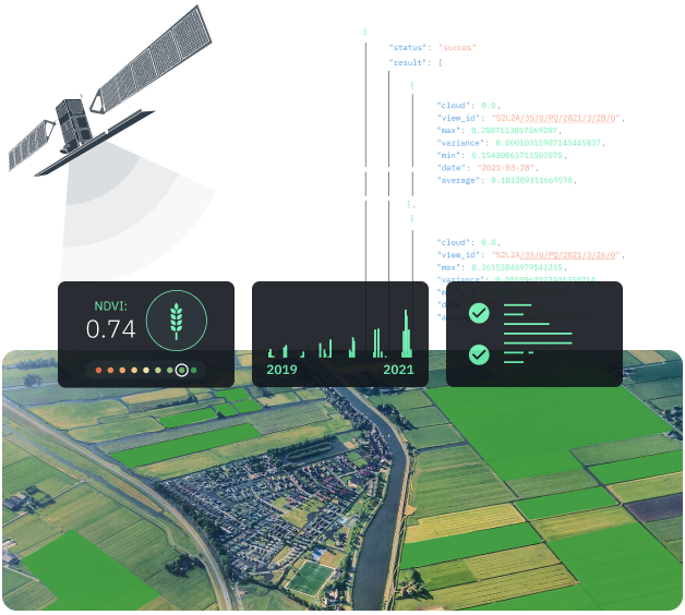
Advanced Vegetation Indices
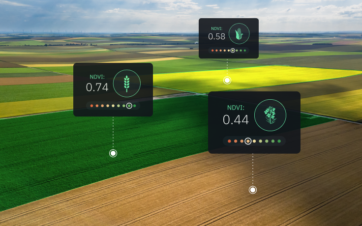
An impressive array of vegetation indices beyond NDVI to remotely measure multiple aspects of crop development for informed agriculture consulting.
- Use the right index at the right time for the right advisory purpose to maximize crop success.
- Build consulting tips using cost-effective VRA maps based on vegetation index values.
- Spot the issues with the crops even at the earliest and latest stages of development and provide timely advisory services, thus preventing unnecessary yield losses.
- Develop the most efficient agricultural consulting tips by accessing custom vegetation indices tailored to specific region, crop type, and more.

Weather Analytics
Advanced weather analytics for agriculture advisory services based on historical data, current measurements, and accurate forecasts.
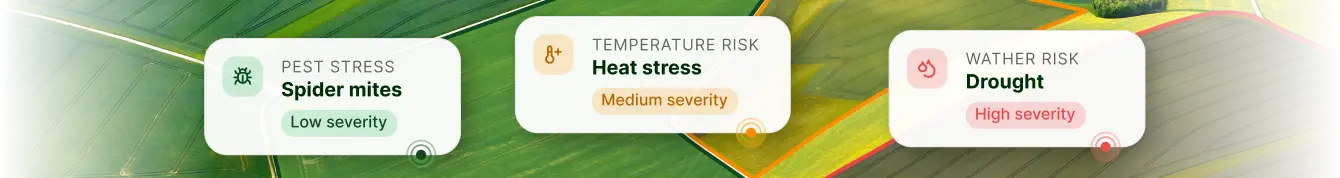
- Enhance planting advisory services by considering potential adverse weather conditions (cold stress, heat stress, water stress, drought, etc.).
- Reduce financial risks related to unexpected changes in temperature and rainfall patterns based on historical data and hyperlocal 14-day forecast.
- Improve field activity planning based on 5-year average temperature and precipitation data.
- Predict agriculture yields based on the historical weather data for a particular field/area.
- Prevent yield loss by getting notified of critical weather conditions.
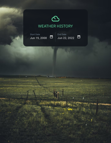
- Reveal the hidden trends of the recurring weather patterns based on data amassed since 2008.

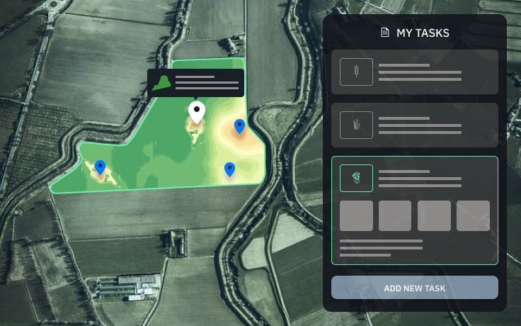
Mobile Scouting App
Mobile software to assist advisory professionals and scouts in the fields.
- Higher transparency between sustainable agriculture consultants and customers via shared account access.
- Allocate scouts more efficiently by managing them online in a single software ecosystem.
- Easily assign tasks in just a few taps.
- Track completion of all scout tasks on one screen.
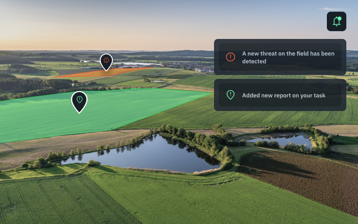
- Scouts can easily use the app in offline mode, take snapshots, add data on crop threats to inform farming consulting, and more.
- Get notified of any scout activities (completion, reports, assigning or reassigning tasks).
- Eliminate paperwork with the detailed online scout reports generated directly in the application.
- Prevent crop failure and yield losses by sending scouts to the exact locations without delays.

Team Management
Shared account for accessing all crop data and delegating tasks in one-stop farming software.
- Level up farming advisory services and client management with quick access to data about every client's field.
- Control the amount of agriculture data you are sharing with farming advisory customers and/or colleagues by adjusting permission settings in the account.
- Instant access to all the necessary information for agriculture consulting specialists, agronomists, scouts, and other team players.
- Build trusted relationships with customers thanks to shared software access to objective farming data.
- Showcase the effectiveness of your consulting to your customers.

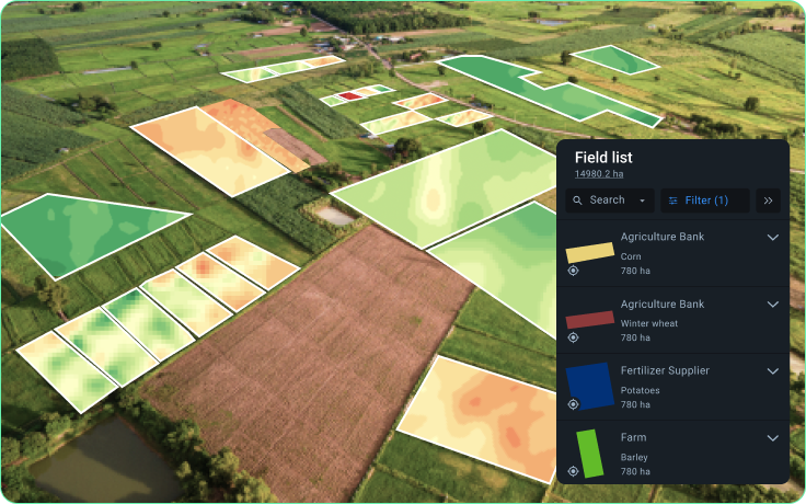
VRA Maps
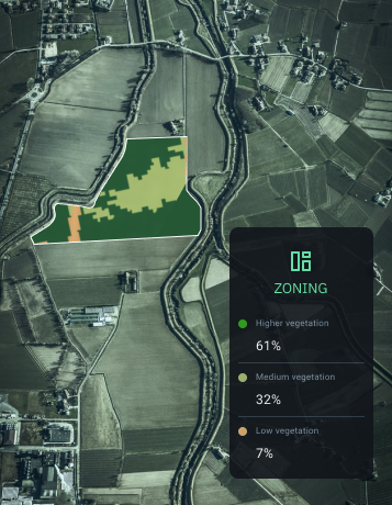
Breaking an agriculture field into zones for a more in-depth crop analysis to eliminate guesswork in consulting.
- Provide advisory services on maintaining day-to-day crop health based on accurate in-zone field analytics.
- Build a competitive strategy to improve crop performance based on the data retrieved for each individual zone of a field.
- Advise your clients on more time-efficient and cost-effective methods of fertilizer application.
- Increase your competitive edge by demonstrating total savings on fertilizer application using our savings calculator.
- Sowing maps, P&K and nitrogen fertilization maps, and multilayer maps from our software can be downloaded to the agriculture machinery.
- Enhance consulting on agricultural input strategies with sowing and P&K fertilization maps based on years of data collected and available in our software.
- Save money while conducting land valuations by taking soil samples in pre-analyzed areas of the field.

Split View
Software tool for comparing different types of data or similar data for different dates on one screen.
- Demonstrate the effectiveness of your consulting services (before and after).
- Discover true causes of low crop performance by comparing multiple layers of data, such as vegetation maps, slope maps, elevation maps, and more.
- Analyze the state of crops using several vegetation indices in one screen.

On-demand Software Solutions
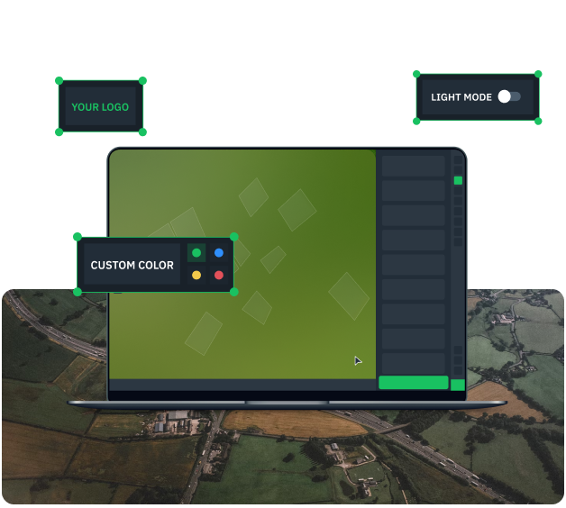
White Label Solution for Farm Advisory Firms
Based on EOSDA Crop Monitoring, our white label software retains all the helpful tools and features plus flexible customization for farming advisory services.
- EOSDA Crop Monitoring under your own advisory company brand and logo.
- Select color theme preferences to your taste.
- Full technical support at every stage.
- Platform hosted on your own domain.
- Mobile Scouting application to complement the platform.
- Super convenient admin panel for managing customers without breaking a sweat.
API for Agricultural Consulting Firms
EOSDA Crop Monitoring features as technical documentation for your advisory website or application.
- Raw, processed, and analyzed satellite imagery for data-driven consulting at your fingertips.
- Wide range of farming statistics - from a single point to the whole region.
- Fast and easy access to weather analytics - 7-day forecast, historical archive, and more.
- Over ten different vegetation indices.
- Multiple sources of data about crops to choose from.
- Historical weather data for farming consulting going back 20 years.
Custom Solutions On Request To Suit Advisory Needs
Software solutions for agricutlure consulting firms and other market players developed by our team of RnD scientists and engineers and successfully tested in the field.
- Enhance advisory strategies by predicting crop yield for upcoming seasons.
- Get ahead of your competitors with agriculture market trends thanks to crop classification maps.
- Field boundaries detected and accurately represented on the map for entire regions.
- Improve harvesting consulting with data on harvest progress across multiple fields at once.
- Advanced soil moisture analytics.

Partnership
Regenerative agriculture consultants are welcome to benefit from EOSDA partnership program.
- Business expansion opportunities via reselling.
- Demos, presentations, training & onboarding sessions, consulting, sales & marketing promotional materials.
- Project discounts, dedicated account manager, press releases & blogs, conference attendance sponsored by EOSDA, and more.
- The most successful resellers get rewarded according to clearly stated criteria.
- Attracting new clients by showcasing successful advisory projects carried out with the help of EOSDA farming software solutions.

Open Up The World Of Satellite Technologies
Satellite Monitoring: Trump Card Of Agri Consultants
Utilizing satellite analytics in diagnostics and addressing crop development issues help agri consultants achieve farm productivity and profitability growth for their clients, optimizing the use of human resources and agricultural inputs.
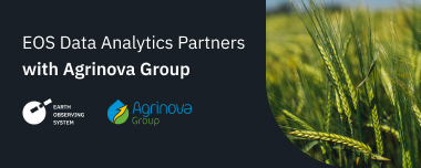
EOS Data Analytics Partners With Agrinova Group
EOS Data Analytics, a global provider of satellite imagery analytics, partners with Agrinova Group, an agricultural consultancy company, to boost satellite monitoring technologies in the Central and Eastern European countries.

How EOSDA Satellite Solutions Serve Agro-Consultancy
Mohammed Altaqatqa, Partner Sales Manager at EOSDA, shares the company's plans for partnerships with agro-consultancies in the US, Canada, Australia, and New Zealand to help them achieve higher yields for their clients by using satellite technology.