CMNP Uses Remote Sensing In Brazil
Brazil, as the world’s leading sugarcane producer, has significantly reduced its use of agrochemicals in sugarcane fields over the past decade. Advances in agricultural practices, such as integrated pest management and biological control, have minimized the reliance on synthetic pesticides . Modern sugarcane farming now employs sustainable methods that help mitigate health risks to agricultural workers and nearby communities, while also reducing environmental impacts such as soil and water contamination. These practices include the use of precision agriculture and biological agents, contributing to a more sustainable sugarcane industry. Despite these improvements, continuous efforts are necessary to maintain and further enhance the sustainability of sugarcane cultivation .
In response to these challenges, environmental authorities developed a range of socio-environmental certification schemes for ethanol fuel in Brazil . Although this initiative exclusively involves sugarcane grown for ethanol and not for sugar, it nonetheless has the potential to significantly enhance the use of agrochemicals throughout the entire sugarcane industry. To secure certification, the producer must adhere to a set of standards, such as providing education and training for workers, implementing proper agrochemical storage, and ensuring the correct utilization of protective gear among others.
The Brazilian company CMNP, founded in 1925, is known for its significant effort in preserving the region’s natural resources: they conserved a few large portions of native forest in several municipalities. From a commercial standpoint, they are one of the largest producers of sugarcane for ethanol. Adhering to the highest environmental standards, the company implemented satellite imagery analytics provided by EOSDA Crop Monitoring. In this case study, we spoke to CMNP representatives who use remote sensing in their daily field operations and discovered how satellite data helps them decrease the use of pesticides while optimizing yields.
Overview: About CMNP
CMNP is leading sustainable development in Brazil by implementing new technologies for optimizing monitoring and harvesting. Some processes are already fully automated. For example, farming machinery for sowing and harvesting is adapted to differentiated input and automated precision control.
After starting to use drones and various agricultural software, the specialists at CMNP realized their next step would be to monitor the entire area at all times. The need to monitor almost 90,000 hectares raised important questions about the cost-effectiveness and accuracy of the technology. They came to the conclusion that satellite imagery analytics satisfy the stated requirements which is why CMNP began using EOSDA Crop Monitoring, an online satellite-based precision agriculture platform.
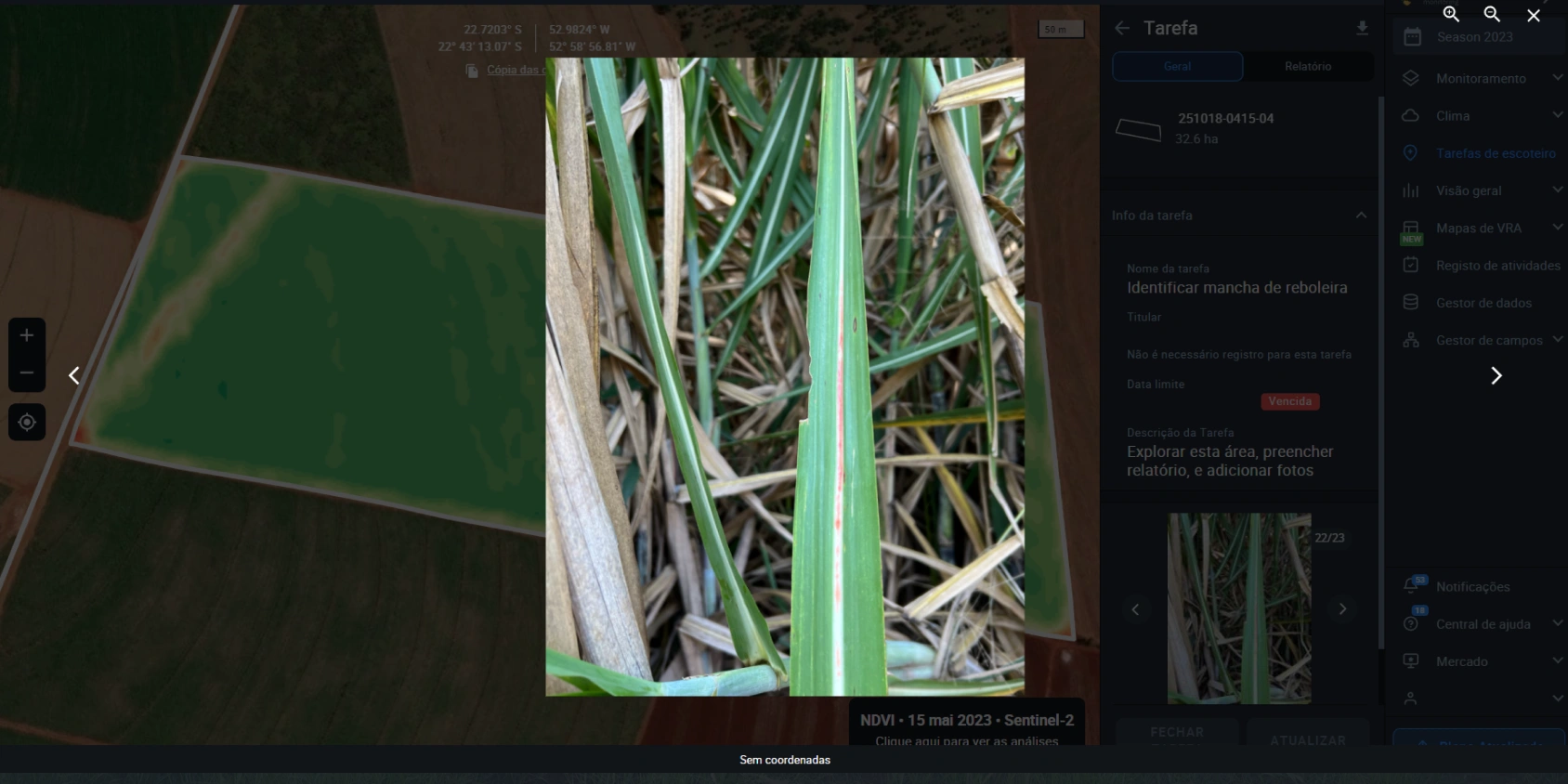
Challenges: Pests & Weeds Infestation, Large Acreage
The biggest challenge for sugarcane crops in Latin America is soil-borne pests. Since it’s difficult to identify them at the stage of propagation, these pests tend to damage significant amounts of crops. As a result, the weeds spread throughout affected locations and continue reducing the amount of sugarcane growing in the fields.
Less environmentally conscious producers resort to aggressive pesticides, which they apply after harvesting. In accordance with their dedication to sustainable development, CMNP wanted to find a way to avoid pests and weed infestation without using too many agrochemicals. They needed to perform remote monitoring of fields to see places where pests begin to spread. Such visibility would allow CMNP to dynamically and responsively come up with the appropriate course of action, avoiding the overuse of pesticides while saving the crop.
The requirements for a technological solution to this issue involved:
- Providing automatic updates of regularly updated georeferenced field condition data, including information about the distribution and prevalence of certain factors in the area represented.
- Availability of detailed, direct, and visual evidence of a specific situation at a particular location.
- Easy sharing and accessibility of data, which can enhance communication and decision-making processes among different stakeholders (like farmers, pest control agencies, agricultural advisors, etc.).
- Integrating different forms of data (like photos and maps) to provide a more comprehensive and contextual understanding of a situation.
EOS Data Analytics provided an easy-to-use EOSDA Crop Monitoring web platform and mobile application to achieve all these objectives. Let’s see how CMNP now uses remote sensing analytics on a practical level.
Solutions: Historical Data Exploration, Vegetation Analysis, Scouting
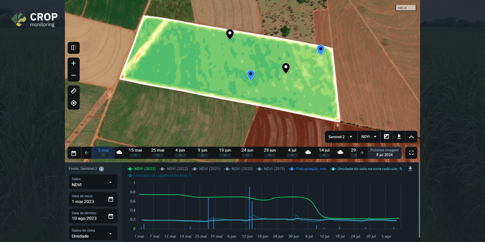
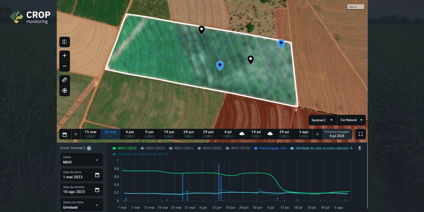
Overall, EOSDA Crop Monitoring is implemented in the daily processes of 20 employees. The vegetational indices and satellite data that CMNP specialists use most often are NDVI (Normalized Difference Vegetation Index) and Natural Color. Alerts are used for checking the latest changes and reacting to possible pest and weed problems. For Zoning, they mostly use VRA Maps. The remote sensing analytics is used for continuous monitoring and response, and reporting to supervisors.
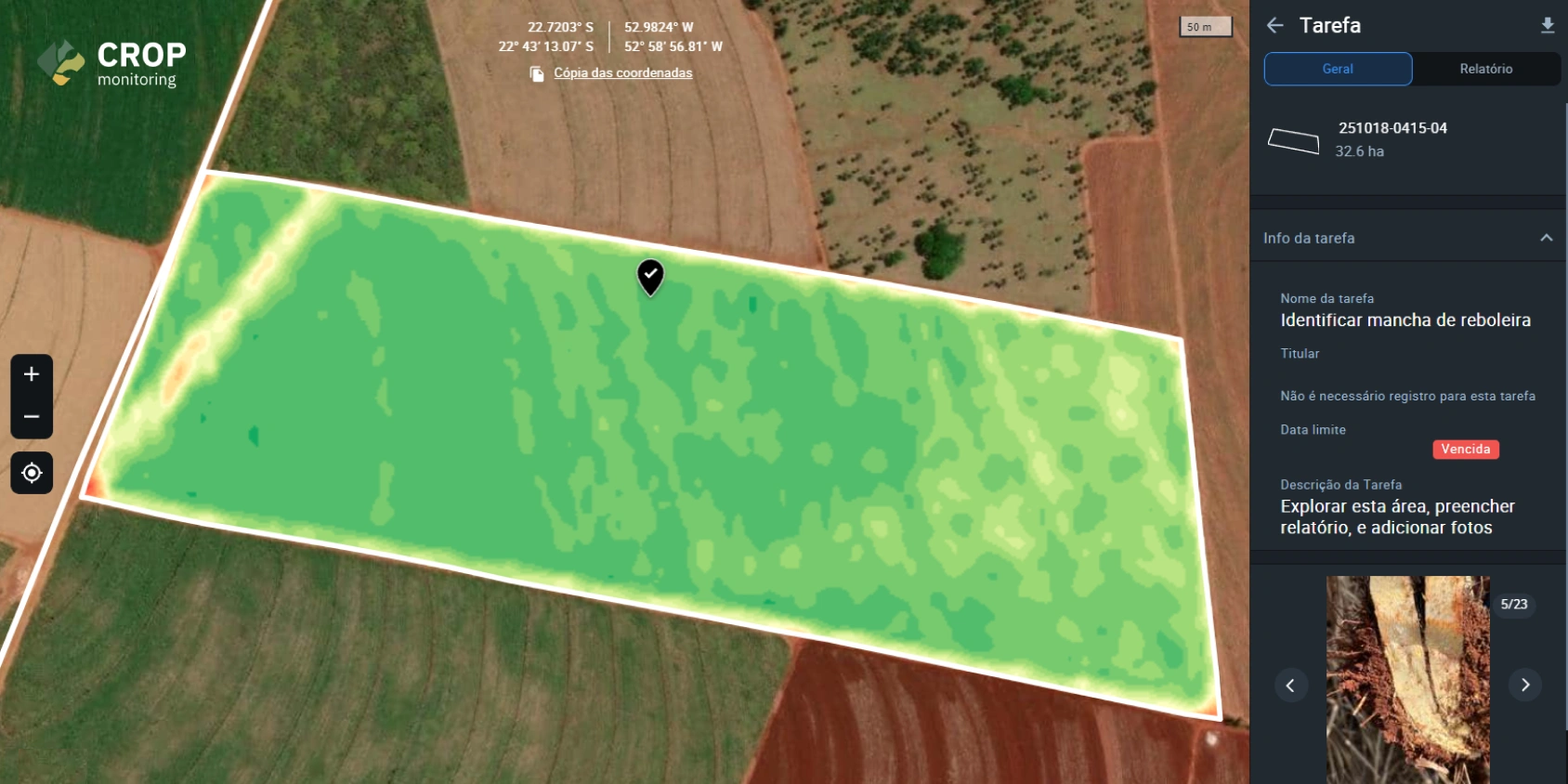
Furthermore, the photos attached to Scouting tasks provide detailed evidence of the pest infestation situation in specific areas of the field, giving a more complete and contextual understanding of the pest situation. When these photos are attached to the VRA map, they enhance the value of the map by providing spatial context to the pest infestation. Sharing this information improves communication and enhances decision-making for pest control strategies.
EOSDA Crop Monitoring provides us with the strategic capability to meticulously evaluate the entire gamut of pest management methodologies at our disposal. Consequently, it enables us to weave together suitable strategies that not only impede the growth of pest colonies but also ensure that any pesticide application or intervention strategies we deploy are judiciously balanced. We do this with an unwavering focus on upholding economic viability, safeguarding public health, and preserving environmental integrity.
Beyond day-to-day monitoring, CMNP agrarians are continuously updating historical field information to facilitate faster decision-making. The primary objective is to gain a comprehensive understanding of field conditions, including the presence of weeds or pests up until the present day. By doing so, they aim to expedite the process of determining the most effective management strategies for their sugarcane crops.
One significant advantage of this updated information is the ability to analyze satellite images, providing insights that might not be evident from on-ground observations alone. The traditional method of sending personnel to assess the fields often turned out to be inefficient, as they may have not always covered the necessary areas.
Ruan Navarro Furtado has been playing a vital role in this endeavor, as he oversees the monitoring process, ensuring that information reaches them in a timely manner, long before any problems escalate. His proactive approach enables CMNP employees to take necessary actions to combat threats promptly.
Results: Faster Decision-Making, Efficient Field Management
By having a broader vision of the entire fields’ conditions from the EOSDA Crop Monitoring interface, CMNP streamlines their decision-making process. This enhanced efficiency enables them to monitor and address potential issues much more promptly, preventing the spread of diseases and weeds. This aligns with their ultimate goal of achieving effective crop management and maintaining healthy fields.
According to Ruan Navarro Furtado, the efficiency of time management in the fields has increased by 50%. Remote identification of problematic patterns allows scouts to precisely identify locations and visit them on a predetermined schedule.
Future plans of CMNP include continuing agricultural business process automation and introducing cutting-edge technology for practicing sustainable development. Integrated crop management techniques like soil conservation, mechanical weeding, mulching, and intercropping will be implemented using the data-driven decisions obtained from remote sensing technology along with in-situ measurements.
About the author:
Maksym Sushchuk is at the forefront of realizing EOSDA's vision to make space tech a global driver of sustainability on Earth. He has over 15 years of experience in journalism and content creation for prominent Ukrainian startups, charitable funds and ESG businesses. As Head and Co-founder of PR Army Maxim brings attention to the human and social tolls of the aggression against Ukraine.
Recent articles

EOSDA Forecasts Yields For 2025 In Saskatchewan
EOSDA created RM-level crop yield forecasts for Saskatchewan to address limitations of official data. The project shows how satellite and weather inputs reveal local yield changes during the season.

Digital Tools Improve Soil Health And Yields In Mexico
EOSDA and ITTA supported a Guanajuato farm with contour-line planning, monitoring tools, and practical guidance to reduce soil erosion and improve yields in the long run.

Analyze 2025 & Plan Your Best Year Yet: LandViewer Christmas Offer
It’s the most wonderful time of the year! The Christmas holidays are here, and so is your chance to analyze 2025 and plan a prosperous 2026 with more affordable Pro plans in LandViewer.