Agribest Confirmed Its Research With Remote Sensing
With climate change and the decreasing amount of arable land available, agri-related companies are looking for solutions that can nourish and enrich the soil at hand. Some of them become very creative in their findings, leveraging science and sometimes even basing their entire product lines on it. One of the great examples of companies that work at the junction of science and agriculture is a Mexican pioneering biotech company, Agribest Technologies. It works tirelessly to deliver the best fertilizers and treatment to its clients.
Agribest’s goal is to promote sustainable farming practices for a Mexican agricultural community to secure soil restoration and protect crops from diseases. But today, agrarians require not just innovative ways to take better care of crops and soil but also tools to measure their efforts. The company turned to remote sensing analytics and started to use EOSDA Crop Monitoring, substantially growing its potential and demonstrating the results of its work to the clients.
| Challenge | Agribest needed to see how its fertilizers react in actual field conditions, instead of solely relying on lab measurements and results. |
| Solution | The company used EOSDA Crop Monitoring features, like vegetation indices, weather reports, and zoning, to visualize how the product impacts the soil and vegetation. NDVI and ReCl indices, along with multilayer maps, allowed to determine the problem plots. |
| Outcome | Agribest has grown its expertise and product value, expanding its market share in Mexico. |
Overview: About Agribest
Agribest Technologies (Tecnologías Agribest) is a Mexican pioneering agro-biotechnology enterprise dedicated to advanced research, development, and innovation. Its primary aim is to deliver effective solutions tailored to the requirements of modern agricultural production, and the mission is rooted in its ambition to enhance the profitability and sustainability of agriculture through innovative means. At the core of the company’s ethos lies the belief that by supporting farmers, it can positively contribute to the broader global community. The goal is to reach one million hectares monitored. Since Agribest currently oversees a bit more than 20,000 hectares, this is only the beginning.
Challenge: Discrepancy Of Laboratory And Field Data
Agribest started its journey in 2013 as a provider of soil restoration services based on its scientific discoveries to its clients. As its laboratory research progressed, Agribest studied various microorganisms: those present in insects, those aiding in soil restoration, and those that make some nutrients soluble. The company used its findings to create new products, fertilizers, and treatments that can help clients improve their yields and fight diseases. Agribest had several cases where it helped its customers to restore their soil.
One of the big challenges, however, was that the results in the laboratory and the field were drastically different. There are many factors influencing product behavior in the open field, and data cannot be accessed in the laboratory’s controlled environment. For instance, moisture levels are dependent not only on the irrigation schedule but also on precipitation and droughts. Ground elevation levels and historical weather conditions can influence the quality of the soil. All those factors, along with the crop peculiarities, can impact how a biotech product reacts in the wild. Agribest had experience all throughout Mexico when a soil analysis was not ideal for agricultural treatment because a laboratory sample was made every 3 years and represented up to 50 hectares, which was not enough to drive a conclusion.
In 2019, Agribest welcomed the issue of data discrepancy with logbooks, a measuring tape, a potentiometer, and a temperature gauge. As the company developed, it acquired more precise tools. However, the issue still prevailed, as there was a lot of data to collect, and one employee with a measuring tape could not cover as much ground as, for instance, satellite monitoring could.
In 2022, Agribest decided to use EOSDA Crop Monitoring, a satellite-based platform for precision agriculture, to investigate this issue in more depth.
Solution: Vegetation Indices, Weather Reports, And Zoning
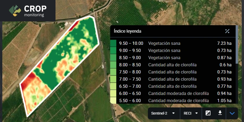
The platform enhanced Agribest’s ability to evaluate the effects of its products. Diverse spectral indices gave the company the opportunity to justify the behavior of the microorganisms and the restoration effect on the soils. For instance, the ReCl (Red-edge Chlorophyll Vegetation Index) shows the nitrogen-fixing bacteria in the field. This index reveals the nitrogen levels in the plant that are not visible to the naked eye. Agribest provides farmers with ReCl maps that visualize the effect of these bacteria on nitrogen levels in the form of multispectral images, like the one you can see below.
Agribest’s specialists were even more surprised, as EOSDA Crop Monitoring helped them not only to prove their results but also to strengthen their work because of the amount of data available on the platform. For instance, indices can sometimes even change the diagnosis for the crops as they assist in seeing the whole picture. Having more data can impact which treatment Agribest advises its clients. There was a case with a 32-hectare field of red tomatoes that required treatment. With the help of NDVI (Normalized Difference Vegetation Index) and ReCl indices, the company identified that only six hectares were affected and required treatment. That saved clients money on the fertilizer and reduced the company’s time spent on treatment processes while also protecting plants and soil from excessive chemicals like Carbofuran, Methyl parathion, and Glyphosate that are neither registered nor verified.
Another situation where EOSDA Crop Monitoring proved itself useful was when it helped identify Ralstonia disease in banana trees on one plantation. Thanks to the discrepancy on an NDVI map, the company employees noticed the disease and applied fertilizer to prevent its spreading. The result was that Ralstonia was stopped, and the product application was both corrective and preventive. Once the fungal disease is detected in the plant root using satellite imagery analytics, the company can swiftly generate a solution to nourish and stimulate the plant.
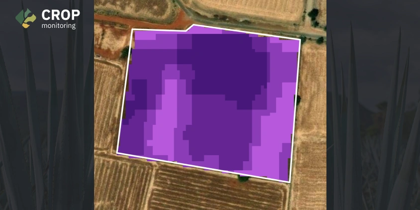
Agribest obtains data that helps predict the entire season ahead and plan what inputs will be necessary in the client’s field. The weather and historical data from the past seven years are added to the equation of the perfect crop care formula, as they help identify recurring phenomena and issues. Productivity, Multilayer, and Elevation maps help determine which parts of the field were affected by the particular problem.
Some clients ask how we identify specific issues in their plots without physically inspecting the fields. We explain that EOSDA Crop Monitoring, the platform we use, allows our specialists to monitor plot conditions remotely through remote sensing technologies. This means they don’t need to personally visit the fields or disturb the clients and can inform them about any issues from a distance. Additionally, our specialists use the platform’s historical data to pinpoint when a problem began. Clients are amazed by this capability, making us seem like sorcerers.
Outcome: Proved Product Value And Elevated Business Indicators
With all data available in the EOSDA Crop Monitoring platform, Agribest is empowered to develop new products and test them out using remote sensing analytics. The effectiveness of existing products is now easily shown to clients. An Agribest specialist applies the product to the field, whether via machinery, drone, or any other way the client wants it, then notes the last and next satellite overpasses and uses a substantial amount of data, including diverse indices, to prove the product’s impact.
With the improved operation processes, business indicators also grew. Engineers on the staff, serving as advisors nationwide, no longer make unnecessary trips to check conditions on-site as the data they need is already available in EOSDA Crop Monitoring. Thanks to this, Agribest’s market penetration has risen by 25%.
The company’s credibility has increased by 90%, as seen in product sales, since it can now provide demonstrations to its clients, and the latter trust the products and processes more as they see the results themselves. The value of Agribest increases by up to 30% every year. All of this allows the company to grow more rapidly by expanding into broader markets and raising awareness of sustainable farming practices in Mexico from an input supplier point of view. Companies like Agribest are pioneers in the agro-biotech field, and their work will certainly invite more and more enterprises to adopt innovative practices for agriculture.
About the author:
Kseniia Kunakh has over 6 years of writing experience, working in various domains, including business, educational, and media-directed texts. Kseniia’s previous experiences as a development manager in a Ukrainian eco-NGO and as a talent matcher in an IT company make her a perfect combination of someone who is passionate about eco-tech innovations and can communicate about them with ease.
Recent articles

EOSDA Forecasts Yields For 2025 In Saskatchewan
EOSDA created RM-level crop yield forecasts for Saskatchewan to address limitations of official data. The project shows how satellite and weather inputs reveal local yield changes during the season.

Digital Tools Improve Soil Health And Yields In Mexico
EOSDA and ITTA supported a Guanajuato farm with contour-line planning, monitoring tools, and practical guidance to reduce soil erosion and improve yields in the long run.

Analyze 2025 & Plan Your Best Year Yet: LandViewer Christmas Offer
It’s the most wonderful time of the year! The Christmas holidays are here, and so is your chance to analyze 2025 and plan a prosperous 2026 with more affordable Pro plans in LandViewer.