Land Biomass In Brazil Calculated Using Remote Sensing
Science is called upon not only to dwell with dark matter. Some researchers look at real-life challenges and solve them using modern tools and innovative techniques. One such challenge is calculating how much biomass one plot can produce to ensure sufficient livestock feed. Alisson Rocha da Silva from the Federal Institute of Rondônia, Advanced Campus of São Miguel do Guaporé in Brazil decided to research this question and made sure to do it as innovatively as possible.
Calculating biomass levels involves labor-intensive methods like manually counting plants in the field. Alisson needed a remote sensing tool that could help assess the required data quickly and efficiently, without leaving the office. He applied to the EOS Data Analytics Academic Outreach Program and used EOSDA Crop Monitoring, an online satellite-based precision agriculture platform for field monitoring. Alisson was able to use vegetation, moisture, and temperature data to calculate the biomass and ensure the applied fertilizer was enough for the next season’s crops. Read on to learn more about his research.
| Challenge | Alisson Rocha da Silva needed to calculate the biomass of the near-university pastures to ensure animals got the required food. For that, he needed to know the edaphoclimatic conditions for specific crops in the areas of interest (AOI). |
| Solution | Alisson applied to the EOSDA Academic Outreach Program and got access to EOSDA Crop Monitoring to evaluate the biomass. He and his team used the vegetation indices, moisture levels, and daily temperatures, combined them with the algorithm from the available literature, and determined the biomass. |
| Outcome | Now, Alisson could determine how much fertilizer to use for the next sowing period and, subsequently, how much land can feed the required number of livestock. |
Local Context: Under-Utilization Of Land And Low Productivity
Alisson Rocha da Silva is a professor of Agronomy at the Federal Institute of Rondônia, Advanced Campus of São Miguel do Guaporé. His research is done in the fields near the institution’s grounds. Although the region is important to the agricultural sector, Alisson and his team realized that it still had structural problems, namely, under-utilization of land or low productivity. In the context of pasture use, the methods involved the arbitrary placement of animals per unit of area, following traditions passed down between livestock farmers, from father to son, or even indications without agronomic criteria disseminated by commercial representatives of inputs.
The low productivity of the land was directly correlated with the amount of livestock the organization could feed. Alisson took it upon himself and his team to figure out how to calculate the biomass levels to see how much cattle food is produced. The researcher’s goal was to find out how to increase agricultural productivity in the context of precision agriculture and remote sensing. This endeavor required high-resolution satellite images and ML algorithms .
Focus: Edaphoclimatic Limitations For Crops
Alisson’s team at the Advanced Campus of São Miguel do Guaporéof the Federal Institute of Rondônia has several short-, medium-, and long-term strategic objectives. Among them are sustainable development, training citizens capable of transforming social reality, and promoting and training in using and developing innovative solutions for societal advancement. Thus, it was essential to study the livestock feeding problem not only for the institution’s purpose but also for the greater population.
In this case, the research team wanted to determine the parameters required to calculate the biomass and make conclusions. Some agricultural productivity metrics require additional tools, like precipitation or temperature measurements, while others require a lot of calculations. For instance, assessing the vegetation levels in a single field might be challenging when done manually, even if the field is relatively small.
Biomass calculations need several datasets, including data on plant roots, stems, leaves, and generative and reproductive organs. One can either measure biomass manually using formulas manually or with additional tools like machine learning algorithms. Alisson chose the second option, using our crop monitoring technology as the primary data source.
It was a complex task to determine what limitations a particular crop faced from an edaphoclimatic point of view.
Edaphology is a branch of soil science that focuses on the influence of soils on living organisms, particularly plants, and the use of land for plant growth. “Edaphoclimatic” refers to the combined impact of soil (edaphic) and climate (climatic) factors on the environment, particularly in relation to plant growth and agricultural practices.
Edaphoclimatic factors directly influence plant development, as they represent the environmental or, more specifically, ecosystem impact on crop growth.
Research: Satellite Analytics To Help With The Research
From late 2023, researchers used several EOSDA Crop Monitoring features to calculate biomass and assess edaphoclimatic conditions.
In the context of your product, we developed techniques to increase productivity by monitoring the soil and climate characteristics to which an agricultural crop is subjected, such as humidity, hours of light, nutritional balance, etc.
Let’s dive deeper into the process.
Methodology: Vegetation Indices, Soil Moisture, And Daily Temperature
The image below shows a dairy farm where rotational grazing is practiced. Earlier, it was unclear how much biomass was produced and how many animals it could feed. It is one of the AOIs Alisson and his colleagues observed.
This field is a pasture cultivated with Panicum maximum cv. Miyagi, a species widely used in the region. The team used vegetation indices to estimate the green mass. With that, they would be able to use the area rationally, calculating what they call the animal stocking rate, which ultimately tells them how many animals can be sustained in the area over a given period.
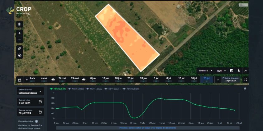
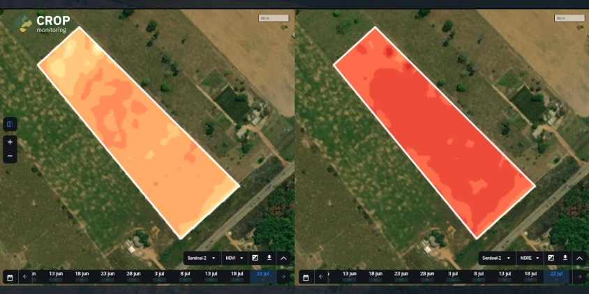
The first step of the process was to collect the data. The different functions of the EOSDA Crop Monitoring platform have helped the team a lot in this. They used vegetation indices to monitor crop development. Those indices show the greenness of the plant, so the changes in color can signify stress factors, such as malnutrition or disease.
Soil moisture content was another helpful metric. Calculating it helps detect how much moisture is in the soil and ensure enough irrigation levels. The data enabled the team to verify whether the crops received sufficient watering.
The third function the team used was daily temperature monitoring. This function provides weather data on a daily basis plus a forecast for the next 14 days. It is beneficial for assessing the climatic conditions and ensuring enough watering on dry days.
The team then analyzed the data and came up with the formula to calculate biomass.
Through the application, we correlated vegetation indexes with algorithms from existing scientific literature related to biomass and fertilization.
Results: Biomass Calculated
The results were calculated biomass based on the platform data and edaphoclimatic conditions.
Since adopting EOSDA Crop Monitoring, Alisson and his team have accurately determined the productivity parameters. They successfully planned animal stocking rates in pasture areas, predicted crop productivity, and set nitrogen fertilizer doses for summer crops such as maize, pasture, and sugar cane.
The team emphasizes that they have gone from a complete non-use of productivity tools to an increasing use of remote sensing solutions within their institution.
Impact: What’s Next?
The Advanced Campus of São Miguel do Guaporé of the Federal Institute of Rondôniaʼs academic community will produce at least one piece of research aimed at applying vegetation indexes to predict pasture productivity by the end of 2024. Other initiatives scheduled between the second semester of 2024 and the end of 2026 are soybean crop monitoring based on vegetation indices, rotational grazing management using biomass data obtained through vegetation indices, and comparing NDVI indices obtained from satellites and RPAs.
Alisson believes that this research can also be a basis for working with communities and ensuring local populations know how to take care of their land sustainably. It will help avoid underutilization and low land productivity in the future, helping secure communities’ well-being.
The EOSDA team admires researchers like Alisson Rocha de Silva, who does an important job of promoting sustainable agriculture in Brazil and beyond. Their scientific work expands farmers’ understanding of remote sensing tools and other innovative solutions for sustainable farming. Scientific publications are usually available to wider populations, so anyone willing to replicate the research can do so. And the EOSDA Academic Outreach Program is open for any scientists who wish to dip their toes into the future.
About the author:
Kseniia Kunakh has over 6 years of writing experience, working in various domains, including business, educational, and media-directed texts. Kseniia’s previous experiences as a development manager in a Ukrainian eco-NGO and as a talent matcher in an IT company make her a perfect combination of someone who is passionate about eco-tech innovations and can communicate about them with ease.
Recent articles

EOSDA to Monitor Wildfires in Portugal Using Satellite Data Under ESA’s InCubed Programme
The company signed a contract with ESA to create an innovative satellite-based solution for forest monitoring and wildfire prevention.

EOSDA Forecasts Yields For 2025 In Saskatchewan
EOSDA created RM-level crop yield forecasts for Saskatchewan to address limitations of official data. The project shows how satellite and weather inputs reveal local yield changes during the season.

Digital Tools Improve Soil Health And Yields In Mexico
EOSDA and ITTA supported a Guanajuato farm with contour-line planning, monitoring tools, and practical guidance to reduce soil erosion and improve yields in the long run.