Choosing the wrong spatial resolution for satellite monitoring means you either overpay for data granularity you do not need or you end up blind to critical details. For example, a broad 10-meter-resolution satellite view is perfect for tracking regional urban expansion, but completely useless if you need to verify a contractor’s roof installation. The key to cost-effective satellite oversight is matching the spatial resolution to your specific business tasks. Our guide explains what different spatial resolutions deliver, so you can find the perfect fit for monitoring your assets and managing projects.
Why spatial resolution matters for your business
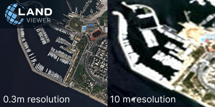
Spatial resolution in satellite imagery is simply the size of the smallest detail a single pixel can capture. For instance, if you are assessing port activity, a 0.3 m resolution lets you count every vessel and map out the piers, while a 10 m resolution blurs the port into a fuzzy shape. That is why picking the right level of detail is so important.
When your business needs to make decisions based on specific land conditions, detailed satellite imagery allows you to:
- pinpoint small assets, vehicles, or property boundary changes;
- inspect roads, pipelines, and other remote infrastructure;
- assess storm or flood damage to structures;
- track construction milestones and verify land activity.
Choosing finer spatial resolution saves time and prevents costly mistakes, especially in time-sensitive areas . Still, it means smaller coverage areas and higher costs, so it’s always best to match the pixel size to your operational goal, buying only the detail you actually require.
What you can see at every spatial resolution
Satellite imagery resolution is never one-size-fits-all. A spatial resolution that perfectly captures a continent-wide weather pattern will completely miss a property boundary change or a rooftop defect. Understanding exactly what each pixel size reveals on the ground is the only way to avoid both data gaps and unnecessary expenses.
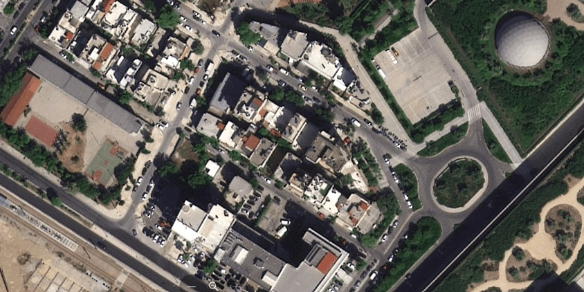
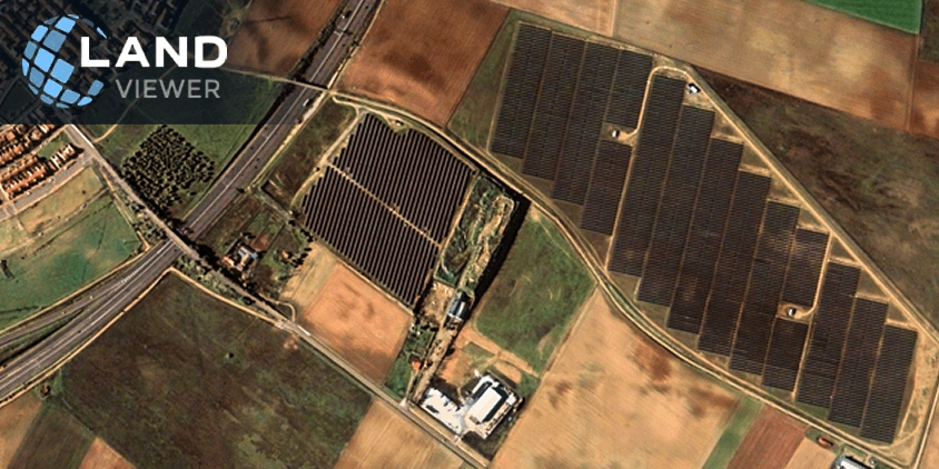
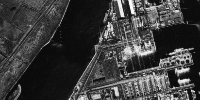
Ultra-high (30–40cm)
At ultra-high spatial resolution, satellite imagery shows individual vehicles, roof structures, container stacks, and construction equipment . You can even distinguish smaller features like narrow paths, landscaping bushes, and individual vines.
Instead of sending teams for physical site inspections, companies use these commercial satellite images to track project locations from their desks, including:
- checking roof layouts, counting parking spaces, evaluating property conditions with satellite photos, and assessing landscaping quality before real-estate transactions;
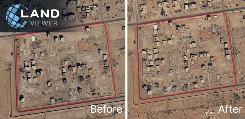
- verifying storm or flood damage, spotting property-level debris, and running pre- and post-event comparisons to process insurance claims faster;
- monitoring jobsite organization, checking material storage, tracking daily equipment placement, and measuring logistics-yard occupancy;
- auditing access roads, checking fenced areas, and spotting unauthorized vehicles or unusual site disturbances.
Skipping routine site visits is the biggest win here. You avoid wasting hours driving out to a remote location just to check a roof condition or see if a contractor actually showed up. With LandViewer’s ultra-high spatial resolution, you can run the audit from your screen and only send people when there is an actual problem to fix.
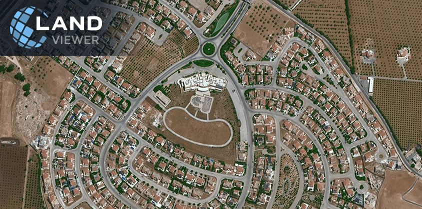
Super-high (50–60 cm)
Super-high spatial resolution is the middle ground for commercial monitoring. It is not designed for spotting small bushes or cars, but it clearly captures trucks, construction equipment, building footprints, and access routes. It shows you the overall layout and activity of a facility rather than tiny details.
This spatial resolution suits well for tracking progress and managing commercial sites without losing the big picture:
- monitoring construction progress, such as new foundations, completed structures, material stockpiles, and the expansion of site footprints;
- mapping haul roads, tracking excavation zones, and monitoring the general movement of equipment and waste piles across the mining site;
- identifying logging clearings, mapping out access roads, tracking forest boundary changes, and assessing large-scale canopy loss;
- comparing parcels, counting buildings, and analyzing development density;
- tracking truck presence, container yard occupancy, and changes in storage capacity.
Balancing detail with coverage is the main advantage at this spatial resolution. You get enough clarity to handle daily operational tasks and track site activity, but you cover a much wider area more efficiently. Choose super-high spatial resolution on LandViewer when you need to audit expansive facilities or whole neighborhoods without overpaying for pinpoint precision.
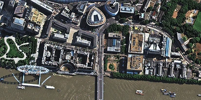
Very high (70–80 cm)
A very high spatial resolution moves the focus away from individual assets and onto broad land-use patterns. You will get a clear look at general building shapes, entire road networks, agricultural fields, and major infrastructure layouts. It answers broader questions like whether a facility exists, how a site is arranged, or how land boundaries change over time.
This spatial resolution works best for screening large regional areas or tracking environmental shifts:
- monitoring remote access routes, checking for new building encroachments near pipelines, and mapping out corridor changes or broad land disturbances;
- tracking the extent of flood-affected zones, mapping erosion patterns, identifying shoreline shifts, and measuring burn scars or land degradation;
- distinguishing field boundaries, checking overall crop patterns, mapping irrigation layouts, and assessing regional farming activity;
- classifying whether land is urban, industrial, or agricultural, and updating general map layouts for expanding towns .
The very high spatial resolution available in LandViewer is a cost-effective choice for wide-scale screening. You get enough structural data to monitor environmental risks, track utility networks, and map large agricultural sectors without drowning in unnecessary details.
High (1–1.5 m)
High spatial resolution is ideal for land-use monitoring and broad operational analysis where the main goal is to understand form, boundary, and spatial pattern rather than small-object detail. It is especially useful when you need reliable regional coverage and temporal consistency. At this level of detail, you’ll see distinct forest boundaries, road networks, and large agricultural patterns.
Typical uses of high spatial resolution remote sensing include:
- tracing how city borders push outward, mapping new neighborhood footprints, and identifying when vacant land transitions into developed blocks;
- mapping timberland edges, monitoring large clear-cuts, and tracing new logging road penetration through dense woods;
- checking wide field layouts, tracking crop block arrangements, and monitoring the expansion or contraction of cultivated land across a province.
When choosing high spatial resolution on LandViewer, you save the budget because you only pay for the big picture. It helps keep large-area maps updated and monitor massive territories efficiently.
When do you need high spatial resolution?
You don’t need a 30-centimeter spatial resolution to tell you if a forest is shrinking or if a town border is expanding. At the same time, a 1-meter detail is completely useless if you need to verify property damage for an insurance claim. Choosing the wrong one either leaves you blind to critical details or forces you to overpay for data granularity you will never use.
The table below outlines the standard level of detail required to handle specific industrial tasks effectively.
| Industry | Recommended spatial resolution | Typical use cases |
|---|---|---|
| Logistics | 30–50 cm | Tracking container yard occupancy, asset screening, and cargo activity monitoring |
| Construction and real estate | 30–50 cm | Progress tracking, checking asset conditions, and property line audits |
| Insurance | 30–50 cm | Individual property damage assessment and post-event fraud verification |
| Mining | 50 cm – 1 m | Mapping haul roads, excavation tracking, and volume calculations |
| Energy, utilities, and infrastructure | 50 cm – 1.5 m | Pipeline corridor screening and remote infrastructure asset tracking |
| Agriculture and forestry | 50 cm – 10 m | Field boundary mapping, crop block arrangement, and timber clearing audits |
| Environmental monitoring | 70 cm – 10 m | Tracking erosion patterns, mapping flood extents, and wildfire burn scar analysis |
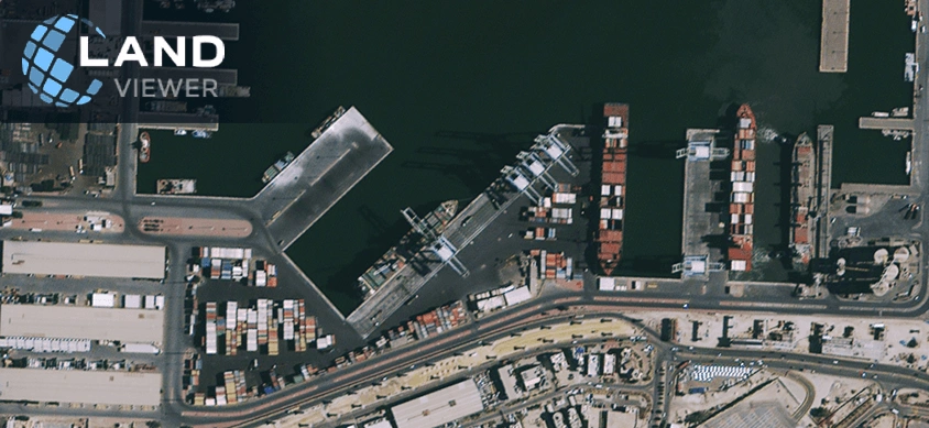
Logistics
Most logistics managers find out about congestion when a driver calls in late. With high spatial resolution, you see the queue forming at the gate before the first truck is even delayed. The detail is specific enough to count trailers in a yard, spot which loading bays are active, identify unused storage space, and compare two competing terminals side by side without a single phone call or site visit. That means you can plan freight routes, evaluate site capacity, and fix daily bottlenecks based on near-real-time ground truth.
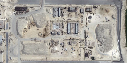
Construction and real estate
Physical site inspections are expensive and slow, yet critical decisions about land acquisition and project timelines depend entirely on physical details on the ground. A satellite image at centimeter spatial resolution lets you skip the travel by showing structural layouts, active heavy machinery, and precise parcel boundaries. You can spot if a contractor is expanding beyond site boundaries, verify material stockpiles, and review nearby access roads right from your laptop. It keeps your contractors accountable and removes the guesswork from portfolio management.
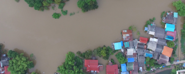
Insurance
Relying purely on a policyholder’s photos makes it incredibly difficult to accurately score risk or validate massive property losses. Integrating high spatial resolution into the claims workflow gives desktop adjusters clear proof of building existence, surrounding wildfire hazards, and actual site changes across thousands of insured assets. You can easily check if a reported loss matches the visible evidence on screen or screen a massive real estate book for new structural encroachments. It cuts down the time spent sending adjusters into hazardous areas just to confirm basic physical facts on the ground.
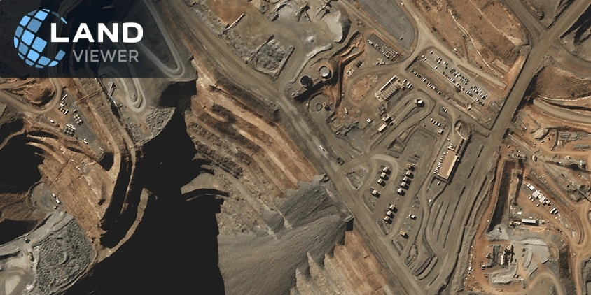
Mining
Mine managers usually track daily haul road conditions and excavation progress through manual surveys, which take hours to coordinate across a massive site. Satellite mining monitoring with submeter spatial detail replaces those slow ground checks. You can map active extraction faces, track where material stockpiles are growing, and monitor heavy equipment movement. It gives engineering and safety teams a fast way to check mine expansion and verify that operations are staying strictly within approved concession boundaries.
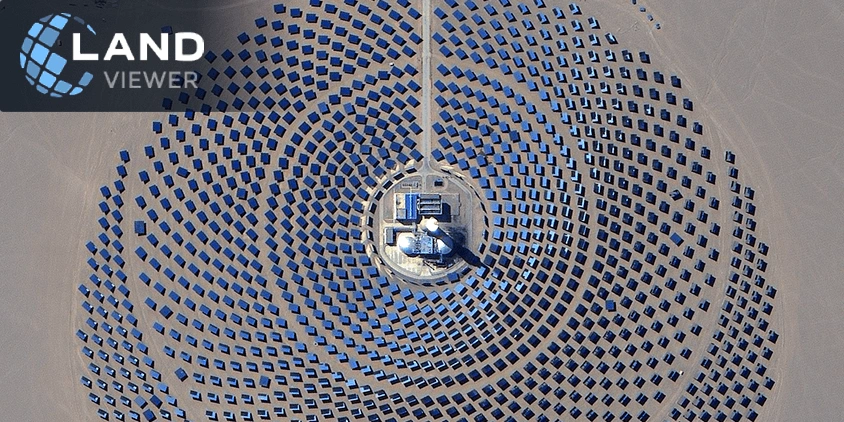
Energy, utilities, and infrastructure
Pipelines, power lines, and rail corridors share one problem: they’re long, exposed, and mostly unattended. Something can change at kilometer 140, and nobody notices until there’s an incident. Satellites with high spatial resolution let infrastructure teams scan entire corridors for encroachment, ground disturbance, vegetation growth, and access changes regularly, and without sending anyone out. That’s the difference between reactive repair and actually staying ahead of the problem.
Agriculture and forestry
What separates precision agriculture from conventional field management is the ability to see inside a field, not just at it. High spatial resolution imagery shows crop row patterns, soil moisture variation, and early stress signals at the level where management decisions actually get made. Forestry works the same way: a satellite at 50 cm spatial resolution can tell you where certain types of trees are, how dense the canopy is, whether a logged area is recovering as certified, and where fire or pest risk is concentrated. Both sectors reward that granularity directly in plant health, cost, and compliance outcomes.
Environmental monitoring
One small regional environmental team might be responsible for monitoring thousands of square kilometers of coastline, forest, and wetland simultaneously. At high or medium spatial resolution, one satellite pass shows which fields have expanded into protected zones, where a river’s floodplain has changed shape, how much of a burn scar has recovered since last year, and whether a mining site’s disturbed area has grown beyond its permitted footprint. That’s not a substitute for fieldwork, but it helps decide where to send people and what to check when they get there.
Every industry covered here operates at a different scale and watches for different things, but the underlying logic is the same: finer spatial resolution reveals more details that you might need for making decisions. Match the level of detail to the question, and satellite imagery stops being background data and starts being a heads-up.
Balancing spatial resolution and budgets with archive or tasking
Archive imagery provides ready-made data for baseline studies, while satellite tasking lets you schedule future captures for near-real-time operations. Smart strategies combine both: start with archives to assess past conditions, then layer in tasking for current activities.
Satellite tasking in LandViewer allows you to tailor spatial resolution and costs. For maximum clarity, you can request ultra-sharp 0.3 m imagery from BJ3N or SuperView NEO-1. For wider regional tracking, 0.7 m data from BlackSky Gen-3 is a more cost-effective alternative. Even intense intra-day timelines are manageable, as you can task BlackSky Gen-2 or Gen-3 satellites to get several high-resolution images a day.
Archives offer less flexibility. However, LandViewer aggregates multiple operators, giving you the best chance to find satellite images with the exact spatial resolution you need.
FAQ
What is spatial resolution?
Spatial resolution is the size that one pixel in a satellite image covers on the ground. For example, a 30 cm resolution means one pixel represents a 30 × 30 centimeter area, while a 10 m resolution means one pixel represents a 10 × 10 meter area.
What is high spatial resolution?
Anything between 30 centimeters and 1 meter per pixel is considered high (or very high) spatial resolution in GIS.
What is the difference between spatial and temporal resolution in remote sensing?
The difference is that spatial resolution refers to the level of visual/physical detail, while temporal — to the frequency of data collection. For example, the SuperView NEO-1 satellite trades off spatial vs. temporal resolution with 30 cm images once a day. In contrast, NewSat provides a slightly lower spatial resolution of 70–80 cm but increases the revisit rate up to 4 times a day.
What is the difference between spatial and spectral resolution?
Spatial resolution defines the visual sharpness and detail of an object, whereas spectral defines the light wavelengths and colors the satellite can capture.
About the author:
Natalia Borotkanych has a PhD in space history, Master’s Degree in Foreign Policy from the Diplomatic Academy of Ukraine, as well as Master’s Degree in Public Management and Administration from National Academy for Public Administration under the President of Ukraine. Natalia's experience includes working in business, science, education, and government projects for over 15 years.

More news
Construction site monitoring: The guide to remote progress tracking with satellite images
From cameras and drones to satellites: a practical look at how construction site monitoring works, where each tool shines, and what a remote, orbital view actually adds.
SAR imagery: How synthetic aperture radar technology works
Want to monitor assets without weather delays? Learn how SAR imagery captures soil moisture, floods, and structural shifts through clouds and smoke for your monitoring projects.
Optical satellite imagery: Getting insights from space
Ground inspections can be slow and expensive. Discover how commercial optical satellite imagery simplifies remote site monitoring and supports daily operational decisions.