
With thousands of satellite constellations in space presently, our planet will witness even more launches in the upcoming years. The existing and new satellite constellations serve many spheres being useful in the internet of things, telecommunications, navigation, weather monitoring, Earth and space observation, to mention a few.
Typically revolving on the low Earth orbit, satellite constellations provide the required data with quick signal transmitting time (downlink and uplink), valuable when immediate response is critical. Compared to single large satellites, swarms of small units (up to 500 kg) are cheaper and faster to deploy.
What Is A Satellite Constellation?
A satellite constellation (or swarm) is a network of identical or similar-type artificial units with the same purpose and shared control. Such groups communicate to worldwide-located ground stations and sometimes are inter-connected. They work as a system and are designed to complement each other. First, satellites in swarms revolve on several, usually similar orbits (orbital planes) ensuring uninterrupted or nearly uninterrupted global coverage. Second, individual constellation units can technically capture a vaster territory compared to a single remote sensing medium.
The number depends on the purpose and varies from several to thousands of units. The largest satellite constellation is Starlink (2,146 active satellites). Examples of the smallest ones are Sentinel missions: Sentinel-2 data is transmited from two units.
GEO vs. MEO vs. LEO Satellite Constellations
Depending on the orbital altitude , there are three different types of satellite constellations: GEO, MEO, and LEO. Each type has its specifics and is important for a particular purpose, so let’s consider how these three compare.
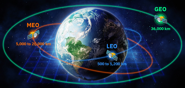
GEO Satellite Constellations
GEO stands for a geostationary (or geosynchronous equatorial) orbit that hosts hundreds of satellites nowadays. Geostationary swarms derived their name from their Earth-rotation mode: they synchronize with our planet’s movement, thus hovering all the time over the same point. It happens because GEO swarms fly over the equator, and each rotation takes 24 hours. GEO is a typical orbit for weather satellite constellations. Others broadcast TV and provide low-speed communication services.
Thanks to the altitude of 36,000 km, an individual GEO satellite can capture 40% of the Earth’s surface. Thus, a group of three units 120 angular degrees apart is enough to keep an eye on the whole world.
MEO Satellite Constellations
MEO is an acronym for medium Earth (or mid-Earth) swarms operating at the altitude of 5,000 to 20,000 km and traditionally serving for navigation purposes. MEO constellations also provide high-bandwidth connectivity in locations where terrestrial infrastructure is poor or not feasible. This particularly refers to maritime and aerospace industries, offshore platforms, and rescue team operations in remote areas.
LEO Satellite Constellations
LEO swarms make the densest space population, operating at an altitude of 500 to 1,200 km. The derived data is widely used by governmental bodies, as well as commercial and non-commercial organizations. Low Earth orbit satellite constellations primarily support research, telecommunication, and Earth Observation needs of environmental monitoring, disaster response, forestry, and agri-sector.
Such swarms may have circular or elliptical orbits . Circular orbits are at the same altitude, while elliptical orbits contain the apogee (the highest point) and the perigee (the lowest one). Swarms with circular orbits revolve around our planet within 1.5 to several hours and typically fly nearly above the geographic poles. As for elliptical orbits, they are passed slower at the apogee and faster at the perigee points.
| Parameter | GEO | MEO | LEO |
|---|---|---|---|
| Altitude | 36,000 km | 5,000 to 20,000 km | 500 to 1,200 km |
| Coverage area | Vast | Medium | Narrow |
| Downlink and uplink rate (signal speed) | Slow | Medium | Fast |
| Ground station spacing | Distant | Regional | Local |
| Antenna | Stationary | Dual-tracking | Complex tracking and terrestrial network |
Why Are Satellite Swarms Important?
The first satellite constellations were launched in the 1960s, and many were deployed from the 1990s up to date. Swarms perform a number of tasks from fiber-like internet connectivity to multi-purpose Earth monitoring, obtaining quality imagery for subsequent AI-powered data procession by analytical platforms. Remote sensing data users particularly rejoice when they can buy services at affordable prices to get clear answers to their questions, and EOSDA is able to provide cost-effective and reliable solutions.
About the author:
Kateryna Sergieieva has a Ph.D. in information technologies and 15 years of experience in remote sensing. She is a Senior Scientist at EOSDA responsible for developing technologies for satellite monitoring and surface feature change detection. Kateryna is an author of over 60 scientific publications.
More news
Construction site monitoring: The guide to remote progress tracking with satellite images
From cameras and drones to satellites: a practical look at how construction site monitoring works, where each tool shines, and what a remote, orbital view actually adds.

SAR imagery: How synthetic aperture radar technology works
Want to monitor assets without weather delays? Learn how SAR imagery captures soil moisture, floods, and structural shifts through clouds and smoke for your monitoring projects.

Optical satellite imagery: Getting insights from space
Ground inspections can be slow and expensive. Discover how commercial optical satellite imagery simplifies remote site monitoring and supports daily operational decisions.