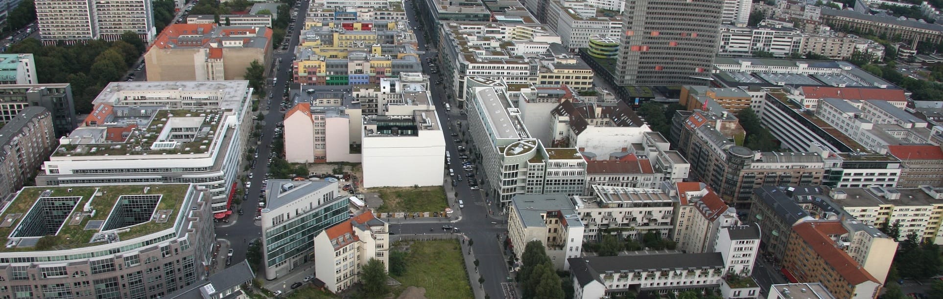
Urban planning covers both the development of open land sites and the renovation of developed parts of the city, in particular, data collection and analysis, prediction, design, strategic planning, economic models and social research. Increasingly, the GIS technology has been applied to map the urban system and to project the consequences of changes.
Using Satellite Imagery In Urban Planning And Development
Currently, lots of cities are developing, therefore there’s a growing demand for up-to-date land topography and land use maps, as well as other spatial data products. These maps are essential to land use development, natural resource management and engineering applications.
Many projects of urban sites planning are based on multi-source remote sensing techniques which are able to ensure best quality data over wide areas. Mapping applications within urban environments are focused on using the latest and least time-consuming approaches to provide the highest product quality at a lower cost.
Medium Resolution Data
Medium resolution satellite data can be applied to perform global spatial queries within urban environments. The wide area coverage allows for vast geographical areas to be covered with a single scene making it a cost-effective assessment tool. Landsat data enables decision-makers to assess the rate of informal settlement occurrence as compared to the rate of new housing development expansion as well as to visualize the patterns of informal settlement distribution in relation to new development projects being delivered. Moreover, it makes it possible to carry out land use trends analysis and identify areas of encroachment and environmental sensitivity.
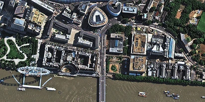
High-Resolution Data
The high-res imagery allows for spatial updates, settlement classification, infrastructure and service provision mapping, green sites development, access control mechanisms and regional planning. The increased spatial accuracy enables action scenario planning and compiles an accurate database of spatial environments.
Panchromatic Data
Panchromatic imagery provides the basement on which powerful tools can be created, in particular environmental planning, asset management, transportation analysis, crime mapping and analysis, disaster management, public safety and Internet based property information access via GIS
How To Use Satellite Data In Urban Planning Across EOSDA Platform Products
Suppose there is a dataset, covering all the settlements of the globe. The settlement details contain boundaries, name, population, administrative arrangement, and the information is constantly updating, saving the previous data therewith. The key benefits of such dataset availability are as follows:
- Supporting the emergency response and disaster relief operations
- Exploring and modeling urban growth patterns around the globe
- Analyzing the human impact on climate change
- Eleborating regional planning strategies in developing countries
- Supporting the huge potential for data fusion in statistics, IoT, location intelligence, autonomous driving, AI and ML fields.
We believe the best place to organize such data would be the OpenStreetMap. Using OSM history and changesets databases, researchers and developers would have access to all the data to track the history of humanity’s progress. The EOSDA Vision team has challenged itself to lead the way in developing the Global Settlements Dataset.
The given case focuses on describing the process of discovering potential settlements in Argentina. For this purpose our team has analyzed OpenStreetMap data, VIIRS night imagery, MaxMind World Cities [license], and created a ready-to-use dataset to launch the targeted campaign for adding settlements’ boundaries to OSM. The procedure is as follows:
- Image pre-processing;
- Intersection;
- Pitfalls;
- Outcome;
- Use case
Image Pre-Processing
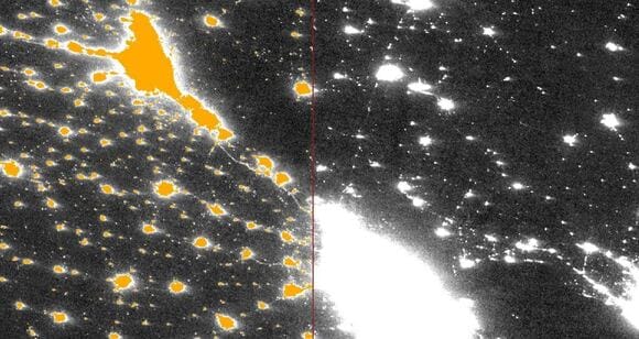
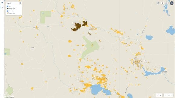
The project to search for potential settlements missing on OpenStreetMap is based on the data from the spacecraft VIIRS as the night mode enables to capture objects emitting light stiffy accurate. The spatial resolution of the sensor is 750 m. The satellite image pre-processing procedure comprises 2 stages:
- Creating a binary mask on the threshold;
- Vectorization of the outcome result.

The image pre-processing was made with the gdal (gdal_calc and gdal_polygonize) tools.
Intersections
The Argentine populated areas are tagged relation [“admin_level” = ”8”] on the map. For the further workflow, the data is uploaded via overpass-turbo.eu.
The binary mask should eliminate all area settlements already used in the OSM
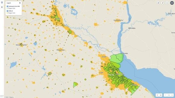
Elimination of the intersection
Pitfalls
The final mask showed two large light source clusters, which turned to be not the settlements. In the process of analysis, we discovered that the first source of the light was an oil derricks concentration cluster and the second presented a power plant.
The similar applies to settlements, we have eliminated intersections with the objects, having the following tags:
- “industrial” = ”oil”
- “power” = ”generator”
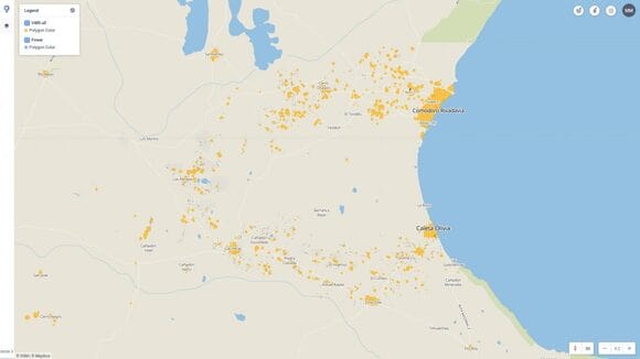
Outcome
As the project progresses, it has been found that many settlements are mapped partially, meaning areas are mapped without the cities’ boundaries. We have specified such cases in the project.
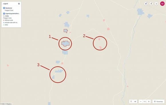
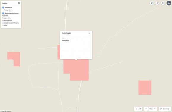
[Legend]:
1) Contains[“land use”=”residential”]
2) No valuable intersection
3) Contains node[“admin_level”=”8”]
Blue color means that the settlement, obtained on the basis of the satellite image has a point with the name of the city in OpenStreetMap. Most likely that point is a real populated area
Red color means a potential settlement that does not intersect with any object from OpenStreetMap.
Red outline means that the object has got intersections with residential areas [“land use” = ”residential”], but at the same time, no borders.
We included the settlements’ points from the Kaggle.com, and excluded all the objects within a radius of 450 m from the points from OpenStreetMap.
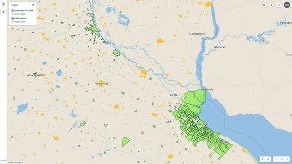
Use Case
Below there is an example of how to apply the project data in searching settlements and drawing on OpenStreetMap.
There is a wasteland on the map:
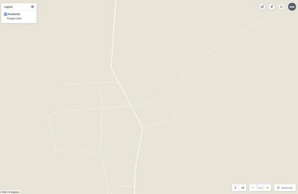
In this area we have also found a potential area settlement and the point from Kaggle.com
Having loaded the WMS layer, obtained from Sentinel-2 satellite onto the given territory, one can see the tested area really contains the settlement
The Next Steps
The EOSDA Vision team is focused on analyzing existing data in OpenStreetMap as well as other global open data projects. Currently, we are making the dataset, containing potential settlements in South America and are heading to the global coverage.
GlobalSettlementsDataset is a huge contribution to the open data concept development.
All the data would be published in a short run. We will keep you updated!
About the author:
Natalia Borotkanych has a PhD in space history, Master’s Degree in Foreign Policy from the Diplomatic Academy of Ukraine, as well as Master’s Degree in Public Management and Administration from National Academy for Public Administration under the President of Ukraine. Natalia's experience includes working in business, science, education, and government projects for over 15 years.

More news
Construction site monitoring: The guide to remote progress tracking with satellite images
From cameras and drones to satellites: a practical look at how construction site monitoring works, where each tool shines, and what a remote, orbital view actually adds.
SAR imagery: How synthetic aperture radar technology works
Want to monitor assets without weather delays? Learn how SAR imagery captures soil moisture, floods, and structural shifts through clouds and smoke for your monitoring projects.
Optical satellite imagery: Getting insights from space
Ground inspections can be slow and expensive. Discover how commercial optical satellite imagery simplifies remote site monitoring and supports daily operational decisions.