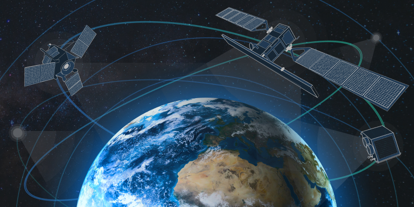
Throughout the years, different types of satellites have become indispensable, supporting diverse activities ranging from broadcasting and navigation to remote sensing of the planet. They serve a variety of purposes, so it’s common to classify them depending on their functions. Several types of satellites’ orbits, each with its own unique set of characteristics, are used for different missions. At the same time, all of the different satellite types, no matter what they’re used for, help us learn more about the planet, connect people in far-flung places, mitigate human-caused and natural disasters, and open up new technological possibilities for humanity.
What Are Artificial Satellites, And Why Are There So Many Types Of Them?
An artificial satellite is any man-made object that has been placed into orbit by means of rockets. These spacecraft are equipped with sensitive instruments and cameras for studying Earth and other planets, aiding communication, and even observing the distant universe. Because of their expansive view field and improved spatial resolution, they can collect information much more quickly than ground-based sensors. In addition, unlike terrestrial observatories, a view from space is unimpeded by any type of atmospheric obscurity, like clouds and dust.
Every spacecraft is sent into space to do a different type of task, whether it be communication, scientific inquiry, weather prediction, or field observation. The purpose of the satellite will determine its size, type of orbit, and overall layout. Although there are various types of artificial satellites and their orbits, all of them adhere to the same physical laws and mathematical calculations once they reach space.
What Are Different Types Of Satellites By Orbit?
In most cases, after being launched, a satellite is placed in one of several predetermined orbits around the Earth. But in some cases, it may be directed to interplanetary journey, following a path around the Sun until it reaches its ultimate destination.
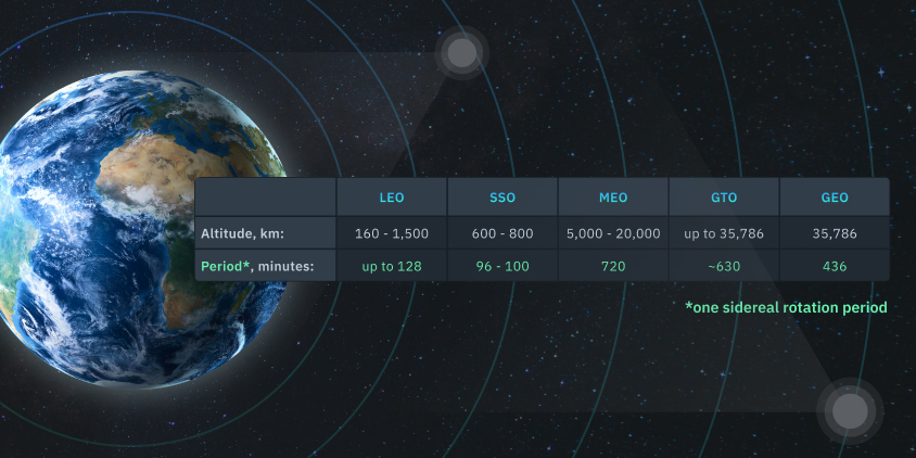
Satellites are usually classified based on their orbital altitude (distance from the Earth’s surface), which directly affects their coverage and the speed at which they travel around the planet. When choosing the type of orbit, spacecraft developers should consider its intended purpose, the data it acquires, and the services it offers, as well as the cost, coverage area, and feasibility of different orbits. The 5 main types of satellites based on their orbits are:
- low Earth orbit (LEO);
- medium Earth orbit (MEO);
- geostationary orbit (GEO);
- Sun-synchronous orbit (SSO);
- geostationary transfer orbit (GTO).
Let’s dig deeper into the nature of these 5 different types of satellites’ orbits to learn more about their characteristics and potential uses.
Low Earth Orbit (LEO) Satellites
Low Earth Orbit satellites are moving at an altitude of roughly 160–1,500 kilometers above the Earth’s surface. They have a short orbital period, between 90 and 120 minutes, meaning they can travel around the planet up to 16 times a day. This makes them particularly well-suited to all types of remote sensing, high-resolution earth observation, and scientific research, as their short orbital period makes it possible to acquire and transmit satellite imagery data in real-time.
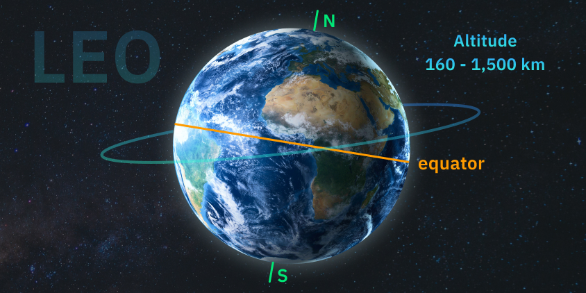
All the types of satellites in LEO can vary the angle of their plane relative to the Earth’s surface. Low Earth type of orbit is very common, as it provides more potential paths for spacecraft to take. However, because of their proximity to the Earth, they have a smaller coverage area than other satellite types. Often, groups of LEO spacecraft, known as satellite constellations, are launched together to form some type of net encircling the Earth. This lets them cover huge areas simultaneously by working together.
Medium Earth Orbit (MEO) Satellites
A Medium Earth type of orbit is located between low Earth and geostationary orbits, typically at an altitude of about 5,000 to 20,000 kilometers. Positioning and navigation services, like GPS, extensively use MEO type of satellites. Recently, high-throughput satellite (HTS) MEO constellations have been put into operation to enable low-latency data communication to service providers, commercial and government organizations.
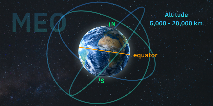
With their longer orbital period (usually between 2 and 12 hours), this type of satellites offer a happy medium between coverage area and data transmission rates. Compared to low Earth orbit spacecraft, MEO ones require fewer devices to give worldwide coverage, but their time delay is longer and their signals are weaker.
Geostationary Orbit (GEO) Satellites
Spacecraft in geostationary Earth orbit are positioned 35,786 kilometers above Earth’s surface, precisely over the equator. Three evenly spaced machines in GEO can give nearly worldwide coverage thanks to the huge area they cover on Earth.
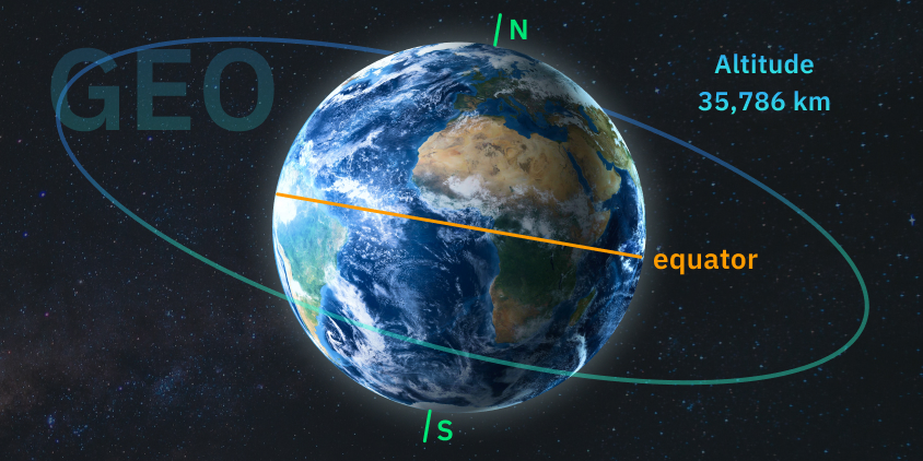
Objects in GEO appear motionless from the ground because their orbital period is identical to Earth’s rotation — 23 hours, 56 minutes, and 4 seconds. This allows a terrestrial antenna to always point toward the same device in space. That’s why this type of satellites is perfect for always-on communication services like TV and phones. Also, this type can be used in meteorology to keep an eye on the weather in particular regions and track the development of local patterns. The downside of GEO type of spacecraft for real-time communication is the longer signal delay caused by their great distance from Earth.
Satellites in geostationary orbit provide observations of cloud patterns that are used to calculate wind speeds.
Sun-Synchronous Orbit (SSO) Satellites
The Sun-synchronous orbit type of satellites goes from north to south across the polar regions at an altitude of 600 to 800 km above the Earth. The orbital inclination and altitude of SSO spacecraft are calibrated so that they always cross any given location at precisely the same local solar time. Thus, the lighting conditions are consistent for imaging, making this type of satellite ideal for earth observation and environmental monitoring.
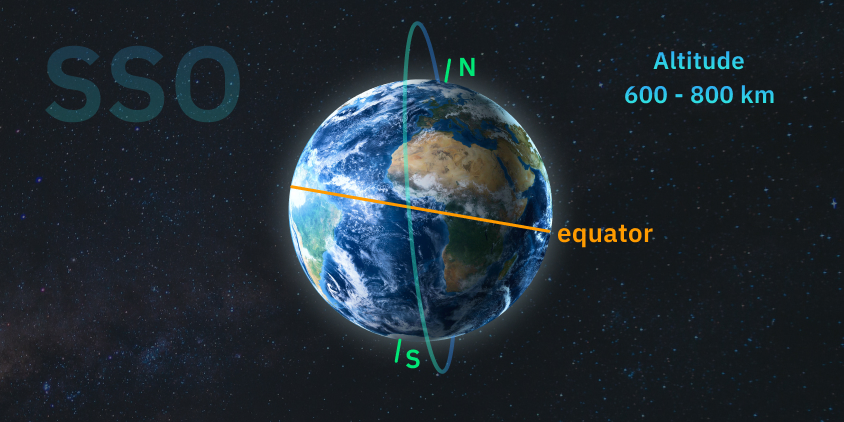
This also implies that SSO’s current and historical satellite images are well-suited for change detection. Scientists use these image sequences to learn about the development of weather patterns, forecast cyclones, monitor and prevent wildfires and floods, and gather information on long-term issues like deforestation and coastline changes. But because of their lower orbital altitude, SSO type of spacecraft can only cover a smaller region at once and need more machines to do so continuously.
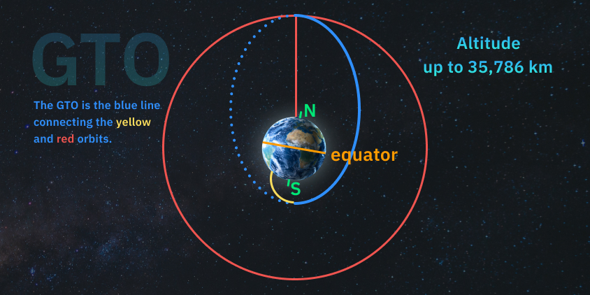
Geostationary Transfer Orbit (GTO) Satellites
The most frequent type of satellite transfer orbit is a geostationary one utilized to migrate from a transition orbit to GEO. Spacecraft are not always placed directly into their ultimate orbit when propelled from Earth into space by launch vehicles such as Falcon 9. Rockets carrying payload to GEO drop it off at transfer orbits, which are halfway points on the path to its final position. Then a satellite’s engine fires to reach its destination orbit and adjust its inclination . This shortcut allows the machine to reach geostationary orbit with minimal resources.
Other, less common orbit types include the highly elliptical orbit (HEO), polar orbit, and Lagrange point (L-point). The objectives and tasks of the spacecraft will dictate the orbital type chosen. Because of this, there should be more thought given to satellite types by applications.
What Are Different Types Of Satellites By Their Functions?
Providing communication and television services is only the tip of the iceberg when it comes to the uses of space-based technology. Many types of satellites have been launched in recent years for a wide variety of scientific purposes, including Earth observation, meteorological study, navigation, studying the effects of space flight on living organisms, and gaining insight into the cosmos. Today, the most common four types of satellites based on their application are:
- communication;
- Earth observation;
- navigation;
- astronomical.
Our in-depth examination of the characteristics of different types of satellites and their functions continues below.
Communication Satellites
A communication spacecraft, usually located at GEO and equipped with a transponder — an integrated receiver and transmitter of radio signals — may receive signals from Earth and retransmit them back to the planet. As a result, it opens interaction channels between regions that were previously unable to communicate with one another due to large distances or other obstacles. Different types of communication satellites facilitate various forms of media transmissions, such as radio, TV, telephone, and the Internet.
Using the communication type of spacecraft, you can relay many signals at once. Spacecraft for broadcasting and TV signal distribution to ground-based stations typically have individual transponders for each carrier. In most cases, though, several carriers will be relayed by a single transponder. Due to its compatibility with mobile terminals, this type of satellites is ideally suited for long-distance communication.

Earth Observation Satellites
The purpose of Earth observation type of satellites is to monitor our planet from space and report back on any changes they observe. This type of space technology makes possible consistent and repeatable environmental monitoring as well as rapid analysis of events during emergencies like natural disasters and armed conflicts.
The goals of the surveillance mission determine the type of satellite sensors used for Earth observation. Information collected varies depending on the type of sensor employed and the available frequency bands.
It is possible to categorize Earth observation spacecraft into the following types:
- Weather satellites are employed for monitoring and forecasting weather trends and providing actual weather data. GEO is ideal for different types of weather satellites, as it provides a constant viewpoint that enables scientists to track cloud patterns and predict their movements.
- Remote sensing satellites’ primary applications are all types of environmental monitoring and geographical mapping. Machines used for different types of remote sensing circle the Earth in one of three orbits: polar, non-polar LEO, or GEO. Geographical information system (GIS) satellites are a type of remote sensing spacecraft whose main function is to provide images appropriate for GIS mapping and further spatial analysis.
Navigation Satellites
The navigation system constellations are located between 20,000 and 37,000 kilometers from Earth’s surface. This type of satellite sends out signals that reveal their time, position in space, and health status. There are two major types of space navigation systems:
- The spacecraft of the Global Navigation Satellite System (GNSS) broadcast signals that GNSS receivers pick up and utilize for geolocation purposes, providing global coverage. Galileo in Europe, GPS in the United States, and the BeiDou Navigation Satellite System in China are all examples of GNSS .
- The Regional Navigation Satellite System (RNSS) is an autonomous regional navigation system that provides coverage on a regional scale. For instance, India’s IRNSS project aims to provide Indian citizens with a reliable location-based service .
Astronomical Satellites
Basically, an astronomical satellite is a giant telescope in orbit. It is able to see well without interference from the Earth’s atmosphere, and its infrared imaging technology can function normally without being fooled by the planet’s surface temperature. The satellite type used for astronomy has a vision that is up to ten times better than the most powerful telescope on Earth.
Spacecraft used in astronomy can be broken down into several distinct types:
- Astronomy satellites are used to investigate different types of celestial bodies and phenomena in space, from the creation of star and planetary surface maps and taking images of the planets in our solar system to the study of black holes.
- The use of climate research satellites fitted with specific types of sensors allows scientists to gather comprehensive, multi-faceted data on the world’s oceans and ice, land, biosphere, and atmosphere.
- Space-based studies on plant and animal cells and structures are possible thanks to biosatellites. Because they allow scientists from different regions to work together, this type of spacecraft plays a crucial role in the progress of medicine and biology.
The vast majority of satellites can perform more than one function simultaneously. Still, it’s a common recommendation that researchers diversify the types of satellites they use to obtain more comprehensive and accurate results of their studies. EOSDA LandViewer is a helpful tool for this because it aggregates space-collected imagery (including high-resolution) from multiple sources and provides a user-friendly interface for finding and downloading the images you need.
Recent Advances In Space Technology And Its Future Prospects
All types of satellites, classified either by orbit or function, have become vital to our daily lives. In addition to facilitating communication, navigation, spatial analysis, weather forecasting, disaster management, and the acquisition of astronomical knowledge, these types of in-space devices also help us get a deeper knowledge of our place on Earth and in the universe.
Thanks to technological advancements, particularly the shrinking of computers and other components, it has become easier to launch different types of remote sensing satellites. In 2022, 6905 active satellites were orbiting the Earth, a whopping 43.8% increase from the previous year’s amount . Sure enough, this number will keep rising, eventually equipping people on Earth with capabilities they could only have dreamed of before.
We must keep pouring resources into space technology because of the vast ways in which it can improve human life. Satellites enable real-time monitoring and data collection from inaccessible regions, letting us make educated decisions on pressing issues like climate change and natural disasters. By expanding connectivity to rural and underdeveloped areas, they can promote economic growth and help bridge the digital divide, leading to a more just and sustainable future for all.
About the author:
Kateryna Sergieieva has a Ph.D. in information technologies and 15 years of experience in remote sensing. She is a Senior Scientist at EOSDA responsible for developing technologies for satellite monitoring and surface feature change detection. Kateryna is an author of over 60 scientific publications.

More news
Satellite imagery tasking: How to order via the LandViewer platform
What if you could just order the satellite imagery you actually need? On-demand satellite tasking makes that possible — here's how it works and how to place your first order.
Digital surface model (DSM): How to map object heights
Need accurate elevation data for structures and land cover? See how digital surface models (DSMs) differ from bare-earth maps and learn how to get high-resolution stereo data for your area.
Digital elevation model (DEM): Guide to terrain mapping
Planning earthworks, drainage, or tower placement? See how digital elevation models reveal true ground contours and how to source site-specific DEM grids without overpaying.