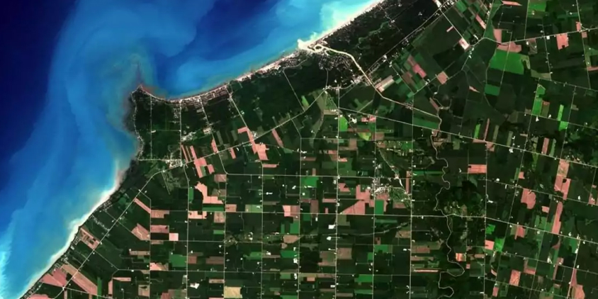
Finding reliable satellite data without breaking the budget is a challenge many businesses, GIS professionals, researchers, and enthusiasts face daily. Fortunately, free satellite imagery has never been more accessible — dozens of platforms now offer high-quality data at no cost. This article presents a list of 10 major sources of free satellite imagery in 2026, covering everything from beginner-friendly interfaces to specialized research portals. Each platform is reviewed across four key parameters: available imagery, search options, download capabilities, and built-in analytics — so you can quickly identify the best fit for your project.
Key takeaways
- We review 10 major platforms offering free satellite imagery in 2026, comparing them by imagery selection, search options, download capabilities, and analytics.
- LandViewer stands out for combining free satellite images from different providers with user-friendly built-in visualization and analysis tools.
- Copernicus Data Space Ecosystem, USGS EarthExplorer, and NASA Earthdata Search offer wide historical data archives, though their interfaces are less beginner-friendly.
- Specialized portals like NOAA Data Access Viewer, Vantor Open Data Program, and ASF Vertex cater to niche needs.
- Narrow your search criteria, check resolution and license limits, and download selectively to make the most of free satellite imagery sources.
LandViewer: Free access to satellite images
LandViewer is a GIS database with an easy-to-master interface that gives free access to the most widely used open-data satellite images, offers free previews of high-resolution satellite imagery, allowing you to select and order only the ones you require, and features extensive analytic tools.
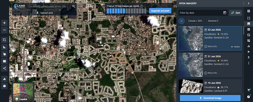
Imagery. LandViewer offers miscellaneous global satellite images. As of 2026, you can get the most recent free satellite images from Landsat 7, Landsat 8, Sentinel-1, Sentinel-2, CBERS-4, MODIS, aerial data from NAIP, or historical satellite imagery from Landsat 4 and Landsat 5.
On the platform, you may also search and preview for free high-resolution commercial satellite imagery from the world’s top providers before deciding which exact pieces to purchase. High-resolution satellite imagery providers you can find in LandViewer include 21AT (BJ3A, BJ3N, and TripleSat), SI Imaging Services or SIIS (Kompsat-2, Kompsat-3, and Kompsat-3A), SpaceWill (SuperView-1, SuperView-2, SuperView-3, and SuperView-4, Gaofen-1, Gaofen-2, and Ziyuan-3), GEOSAT (GEOSAT-2), BlackSky (BlackSky Gen 2 and Gen 3), Improsat (Göktürk-1), and Satellogic (NewSat). The best spatial resolution comes up to 30 cm per pixel from BJ3N and SuperView NEO-1.
LandViewer provides access to various SAR, optical, hyperspectral, and stereo imagery. Medium-resolution optical imagery and SAR data from Sentinel-1 (20-m resolution) are available for download free of charge or under a subscription plan. Meanwhile, high-resolution SAR images, optical, stereo, and hyperspectral imagery is accessible upon individual request.
Search. The search is very simple and straightforward: once you set the Area of Interest using one of the multiple options (including file upload), and pick the dates. Additionally, you are free to select the type of sensor, apply cloud cover percentage, solar elevation, and AOI coverage percentage filters. Make sure to save your Area of Interest and subscribe to new scenes to get notifications about the newest satellite images, free of charge, available for your chosen territory.
Download. When it comes to downloading space-derived imagery, LandViewer has a lot to offer. Let’s imagine you’ve come for a free Sentinel satellite imagery download. What are your options? First, you can download a free full or manually cropped Natural Color Sentinel image in JPEG, KMZ, or GeoTIFF. If you need only specific spectral bands, use the Analytic download tab to get only those you will use. And the third option is downloading a processed image: a band combination or a calculated index.
If you don’t want to store satellite imagery on your PC, use the WMS feature to streamline it for desktop GIS software.
Analysis. Unlike most free satellite imagery providers, LandViewer enables instant visualization and analysis of the data you’ve found. Over twenty default band combinations and indices, such as NDVI, NBR, and SAVI, the raster calculator-like custom index builder, time series analysis, clustering, change detection, and more of its tools are meant to help extract value from satellite data for free.
LandViewer is the best free real-time satellite image provider for GIS beginners and experts from other industries (agriculture, forestry, construction, mining, communications, environmental protection) who don’t use special GIS software and are looking for updated satellite data with fast and accurate analytics included.
USGS EarthExplorer: Free-to-use satellite imagery
The USGS agency has the longest record of collecting free GIS data (satellite images, aerial, and UAV), which is made available via EarthExplorer (EE).
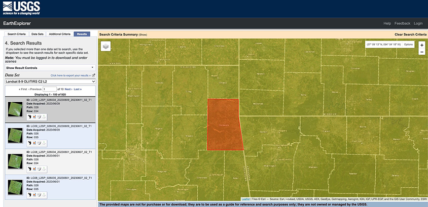
Imagery. The selection of space-derived imagery in EarthExplorer is overwhelming, from optical and radar data to weather satellite photos to digital elevation maps. Using this provider, you will find 40 years’ worth of free satellite images from USGS-NASA Landsat missions and a diversity of data from other NASA remote sensors (Terra and Aqua MODIS, ASTER, VIIRS, etc.). The provider also features free satellite map datasets provided in collaboration with ISRO (Resourcesat-1 and 2), ESA, and some commercial high-resolution space-based images (IKONOS-2, OrbView-3, historical SPOT data).
Search. The provider allows you to narrow down the search for free satellite imagery by area, date, and cloud cover percentage. All the found tiles can be conveniently previewed one by one or all at once.
On top of the standard Area of Interest (AOI) selection options (address, coordinates, file upload, or drawing), the provider’s interface offers a feature-based search, which is pretty fun to test. For free, on satellite maps, you can find all possible features, even less common ones — like ancient roads or graves — anywhere in the world.
Download. For downloading large amounts of the USGS’s free satellite images of Earth at once, you will need to install the Bulk Download Application. Depending on the sensor, various free data products can be downloaded (Level 1-3, natural color and thermal imagery, etc.).
Analysis. The provider’s interface can be used for search, preview, and free GIS map download purposes only. If you want to analyze the retrieved free satellite imagery and maps, you will need special software.
EarthExplorer is an undisputed leader among free satellite imagery providers in terms of data variety, but it is not the most user-friendly, especially for a non-expert. It may take a while to familiarize yourself with all the buttons, menu options, and map datasets available on the platform. So be prepared that your first search for the required free satellite images and maps can be quite time-consuming.
Copernicus Data Space Ecosystem: Up-to-date satellite images for free
Access to all free Sentinel data, along with new visualization and processing tools, is now available through the Copernicus Data Space Ecosystem, which went live in January 2023. Taking over from the Copernicus Open Access Hub (formerly the “Sentinels Scientific Data Hub”), the ESA’s ecosystem is able to quench anyone’s thirst for Sentinel imagery free of charge.
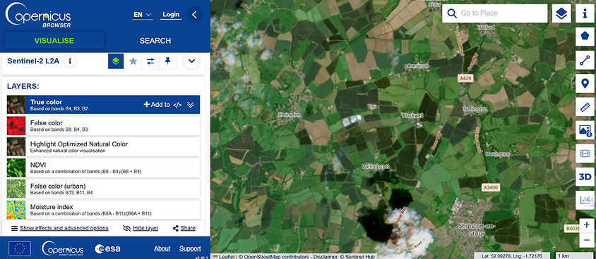
Imagery. Currently, the provider brings to users the most up-to-date free satellite images from all active Sentinels: radar data from Sentinel-1, optical multispectral Sentinel-2 data, Sentinel-3 land products for environmental monitoring, and atmosphere and air quality data from Sentinel-5P.
Search. Since the Copernicus Hub’s interface gives way to the Copernicus Browser, it is now simpler for non-specialists to locate free satellite imagery from this provider. Users can begin by selecting a group of desired satellite missions and then further narrow their choices with the available filters. An AOI can be created from a user-selected bounding box or polygon or imported from a file containing vector geometry. However, not all of the Copernicus Browser’s capabilities and satellite datasets are now accessible.
Download. In the Browser, it is possible to download free satellite images in a few different ways. One of them allows you to save the particular visualization or user-created layers for free.
Analysis. The Browser provides a free visual representation of the search results. It also has several features to facilitate spatial analysis. Some examples are pinning specific locations, measuring distances between two points, and comparing two photos.
The Copernicus Data Space Ecosystem can be recommended as a provider of all the Sentinels’ free updated satellite imagery. In 2026, though, you should be ready to play the part of a tester for this service provider while the new ecosystem is still in its infancy.
NASA Earthdata Search: Access to historical and recent satellite images for free
NASA’s Earthdata Search is the provider of online access to multiple collections of NASA’s EOSDIS (Earth Observing System Data and Information System) satellite data.
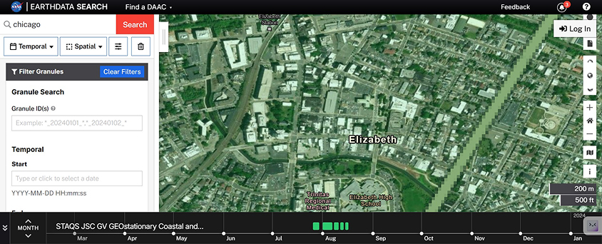
Imagery. In Earthdata Search, you will find a plethora of free NASA Earth science data from different sources, including satellites, aircraft, field measurements, and other programs. The amount of free real-time and historical satellite images enlisted in the “Platforms” tab of this provider is impressive: Aqua and Terra, ENVISAT, GOES, METEOSAT, Nimbus, POES, Landsat, and much more free GIS data that enables the study of the atmosphere, environment, ocean and sea, land cover, vegetation, ice cover, and topography.
Search. You will need plenty of patience to learn to navigate and find free satellite imagery using the Earthdata Search provider. There are tutorials and detailed descriptions for every GIS data collection, but they are of little help unless you know exactly what you’re looking for.
The selection of satellite images (granules) from a long list of collections that match your search criteria seems especially difficult to grasp. But the diversity of the provider’s free imagery compensates for this inconvenience.
Download. Depending on the dataset, free satellite imagery to download may require a few extra clicks to approve certain applications. Also, not all the free data from the provider can be previewed prior to saving to the PC.
Analysis. Unfortunately, this provider doesn’t feature any built-in tools for analysis.
Earthdata Search is truly an ocean of free NASA Earth observation data that a researcher or scientist can dive into. However, it’s not the best free satellite imagery provider for amateurs, who may start with more user-friendly providers and probably come back to it later to fill the gaps.
Google Earth: Free historical satellite imagery at hand
The platform was previously known as Earth Viewer and belonged to Keyhole Inc., which was bought by Google in 2004. In 2005, the platform’s name was changed to Google Earth. The program is available in two versions: ordinary (free) and Pro, and works on Windows, Linux, macOS, Android, and iOS.
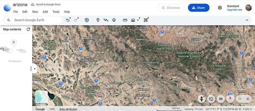
Imagery. Spatial resolution varies by location , reaching up to 15 cm for major urban centers and critical infrastructure sites throughout the US, Western Europe, and East Asia. Free up-to-date satellite imagery from this provider comes from Landsat-8 as well as aircraft, drones, kites, and balloons.
Search. The program allows entering the geographic location and hovering the mouse to zoom. Some satellite imagery offered by the provider may be decades old. You can also see a 2D and 3D representation of Earth for free.
Download. The default file for free satellite imagery is KML or KMZ (zipped). The free version of the provider’s service allows printing images as they appear on the screen, while Google Earth Pro gives access to premium-quality photos and extended datasets, including historical data and importing and exporting GIS data.
Analysis. To make up for the absence of analytical tools in Google Earth, the provider offers a separate platform, Earth Engine, as a free resource to the academic, research, and development communities.
NOAA Data Access Viewer: Free satellite imagery of the coastal US
The free software provider belongs to the NOAA Office for Coastal Management and gives access to satellite imagery of the coastal regions of the contiguous United States, Alaska, Hawaii, and the territories.
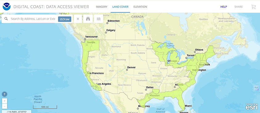
Imagery. Free of charge, the user can choose between three satellite data types: imagery, land cover, and elevation/lidar. The data is sorted out by provider, year (ascending or descending), and dataset name. Free imagery is available in infrared and natural color.
Search. The search options for 2026 recent free satellite images include entering an address, longitude/latitude coordinates, or extent.
Download. To download photos from this provider, you need to add them to the cart, get a link, and select the required file format. The free bulk download is also available.
Analysis. Customized satellite data is provided upon request and shared via an email link. Standard imagery can be accessed through the link in the Viewer.
Vantor (formerly Maxar) Open Data Program: Satellite imagery catalog for rescue in action
The product is designed to help rescue missions manage disasters and respond to emergencies. It is a reputable provider of free information on natural calamities like hurricanes, typhoons, wildfires, floods, explosions, and earthquakes, with brief descriptions and imagery.
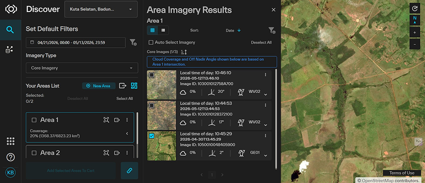
Imagery. Vantor satellites provide high-resolution satellite imagery free of charge.
Search. Using the provider’s Open Data section, you can search for disaster events by year. Several free pre- and post-disaster images are available for each event. Once you expand the year, you will get a full list of viewable events, each with a preview and a total number of available pre- and post-disaster images.
Download. You can save imagery to your computer for free as TIFF files.
Analysis. The provider does not offer any in-app analytical tools.R
NASA Worldview: Regularly updated free hi-res satellite imagery for disaster monitoring
The app from NASA’s EOSDIS allows interactive browsing of full-resolution satellite imagery available globally in near real-time (after three hours of retrieval). With this provider, you can access free up-to-date information on disaster management (fires, floods) and air quality. Browsing is available on a PC, tablet, or smartphone.
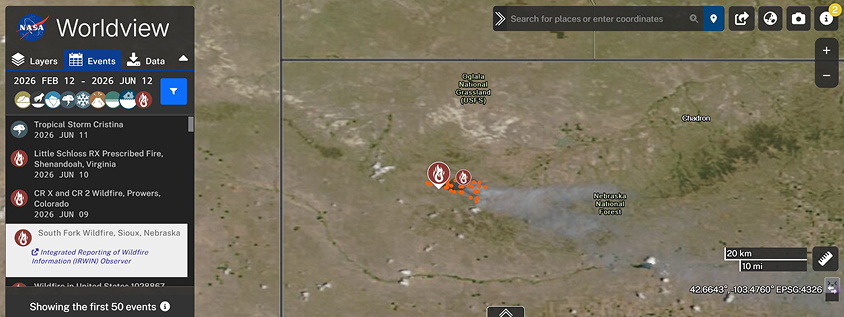
Imagery. The satellite imagery provider offers high-resolution data from MODIS, NASA’s LANCE, EOSDIS DAACs, NOAA, etc.
Search. Searching by events and dates is possible by clicking or swiping the timescale. Most of the imagery is available in standard geospatial projection, including that of the Arctic and Antarctic.
Download. Users of the service provider can download the required free satellite images via the snapshot option, selecting the preferred resolution (30 m–10 km) and file format (JPEG, KMZ, GeoTiff, PNG), or choosing from available layers. The file will be downloaded through NASA Earthdata Search, so registration is required.
Analysis. The provider gives you a plethora of overlays, base layers, and additional layers for multiple modifications to check air quality, dust storms, droughts, floods, vegetation, ash plumes, and shipping, among others.
Detailed online tutorials on how to use and download free satellite images help the provider’s users navigate the tool, highlighting its multiple features.
ArcGIS World Imagery Wayback: Free satellite imagery and geospatial data
World Imagery Wayback by ArcGIS is a free digital archive of World Imagery basemap versions since 2014. It allows users to browse, visualize, and export archived map layers to track environmental or urban changes. The platform requires some technical training, but it is effective for projects that depend on analyzing historical ground changes.
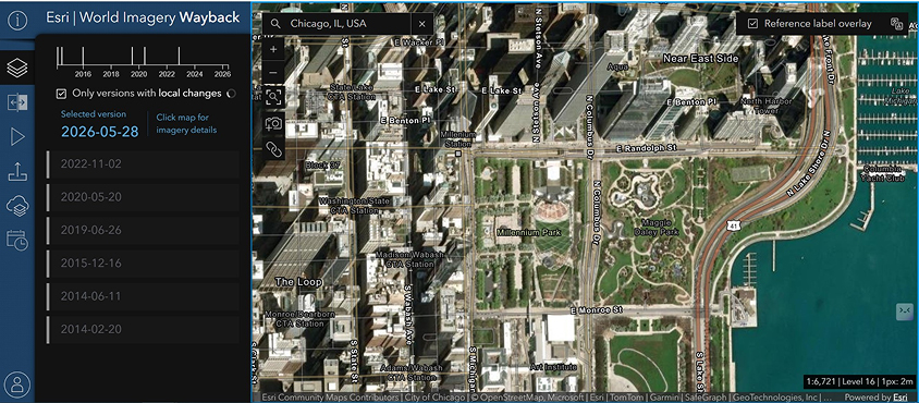
Imagery. ArcGIS World Imagery Wayback integrates free imagery from the Copernicus program (Sentinel-2) and NASA/USGS (Landsat), alongside data from commercial satellite imagery providers like Vantor (WorldView, GeoEye) and Airbus (Pleiades, SPOT) and various basemaps.
Search. The ArcGIS Living Atlas allows users to find historical satellite imagery and geospatial datasets by typing in a specific location and date.
Download. Users can export or download imagery in GeoTIFF, JPEG, PNG, and KMZ, depending on the dataset and their access permissions. Free of charge high-resolution satellite imagery is restricted to basic previews. Downloading it or using advanced export capabilities requires an active ArcGIS subscription.
Analysis. The platform provides basic visualization mods, such as Swipe and Animation. As a part of the broader ArcGIS environment, analytical tools include image classification, change detection, vegetation analysis, land cover mapping, and terrain analysis.
Overall, the platform is a good choice for retrospective change detection. However, due to its limited capabilities, advanced analysis may require upgrading to a paid ArcGIS subscription.
ASF (Alaska Satellite Facility) Vertex: Specialized portal for free radar satellite data
ASF Vertex is a specialized data portal operated by the University of Alaska Fairbanks. It is tailored for researchers and professionals who specifically need radar-based Earth observation.
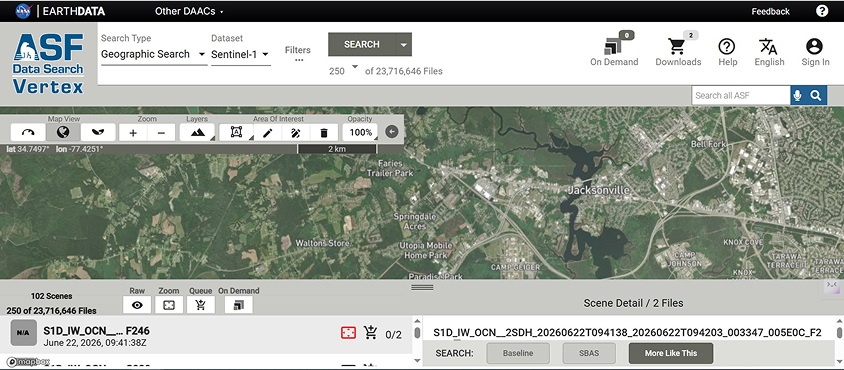
Imagery. The ASF Vertex satellite imagery provider focuses on SAR (radar) datasets, including Sentinel-1, ALOS PALSAR, and RADARSAT missions. SAR sensors capture terrain details independently of sunlight or weather, so they work well for consistent environmental monitoring.
Search. The web-based search interface allows for filtering global archives by radar mission, date range, and geographic coordinates.
Download. Registered ASF Vertex users get access to free radar imagery in standard formats like GeoTIFF and SAFE. Files are available as full scenes or clipped subsets depending on the specific product type.
Analysis. The portal offers basic preview tools to look at backscatter intensity and compare imagery from different dates, but advanced processing (e.g., interferometry or classification) requires extracting this open-source satellite imagery data into external GIS software.
While ASF Vertex is an invaluable source for free SAR data in 2026, it remains a highly specialized tool. Because it focuses exclusively on radar imagery, it lacks standard optical datasets and offers no built-in features for deep analysis. It is best suited for experienced users who already have the external GIS software required to process and interpret raw radar files.
Tips For Making Use Of Free Satellite Imagery Platforms
Here are a few tips to help you choose and make the most of free satellite imagery providers in 2026:
- Choose the right platform. To save you time, we’ve compiled the above list of 10 major satellite imagery providers, including reliable platforms, government agencies, and academic institutions. There are many other free medium- and high-resolution satellite imagery providers out there, but we suggest that you start with these GIS data services for the best experience.
- Learn about the capabilities of different platforms. Free platforms often have strict caps on imagery resolution, historical depth, and available file formats. Review these technical capabilities beforehand.
- Narrow your search. Determine your specific requirements for free satellite imagery, such as the Area of Interest, temporal range, spatial resolution, and spectral bands, and apply the platform’s search filters to refine your findings.
- Explore visualization and analytical tools. Some free platforms only let you view or download raw data, while others offer built-in analytical tools. Ensure that you’ll get the quality, clarity, coverage, and insight to meet your needs.
- Download selectively. Select tiles or Areas of Interest instead of downloading the entire large satellite datasets. By filtering out irrelevant data, you can save time and storage space without sacrificing the information you need for your project.
Always read the provider’s resolution caps, license limitations, and terms of service to ensure that your intended use is in compliance with its acceptable parameters. Following the above guidelines will help you choose the best satellite imagery providers for your needs.
About the author:
Kateryna Sergieieva has a Ph.D. in information technologies and 15 years of experience in remote sensing. She is a Senior Scientist at EOSDA responsible for developing technologies for satellite monitoring and surface feature change detection. Kateryna is an author of over 60 scientific publications.
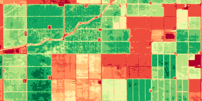
Find satellite imagery in the largest online catalog, analyze it, and download instantly.
More news
Satellite imagery tasking: How to order via the LandViewer platform
What if you could just order the satellite imagery you actually need? On-demand satellite tasking makes that possible — here's how it works and how to place your first order.
Digital surface model (DSM): How to map object heights
Need accurate elevation data for structures and land cover? See how digital surface models (DSMs) differ from bare-earth maps and learn how to get high-resolution stereo data for your area.
Digital elevation model (DEM): Guide to terrain mapping
Planning earthworks, drainage, or tower placement? See how digital elevation models reveal true ground contours and how to source site-specific DEM grids without overpaying.