
Satellite Constellations: Existing And Emerging Swarms
With thousands of satellite constellations in space presently, our planet will witness even more launches in the upcoming years. The existing and new satellite constellations serve many spheres being useful in the internet of things, telecommunications, navigation, weather monitoring, Earth and space observation, to mention a few.
Typically revolving on the low Earth orbit, satellite constellations provide the required data with quick signal transmitting time (downlink and uplink), valuable when immediate response is critical. Compared to single large satellites, swarms of small units (up to 500 kg) are cheaper and faster to deploy.
What Is A Satellite Constellation?
A satellite constellation (or swarm) is a network of identical or similar-type artificial units with the same purpose and shared control. Such groups communicate to worldwide-located ground stations and sometimes are inter-connected. They work as a system and are designed to complement each other. First, satellites in swarms revolve on several, usually similar orbits (orbital planes) ensuring uninterrupted or nearly uninterrupted global coverage. Second, individual constellation units can technically capture a vaster territory compared to a single remote sensing medium.
The number depends on the purpose and varies from several to thousands of units. The largest satellite constellation is Starlink (2,146 active satellites). Examples of the smallest ones are Sentinel missions: Sentinel-2 data is transmited from two units.
GEO vs. MEO vs. LEO Satellite Constellations
Depending on the orbital altitude , there are three different types of satellite constellations: GEO, MEO, and LEO. Each type has its specifics and is important for a particular purpose, so let’s consider how these three compare.
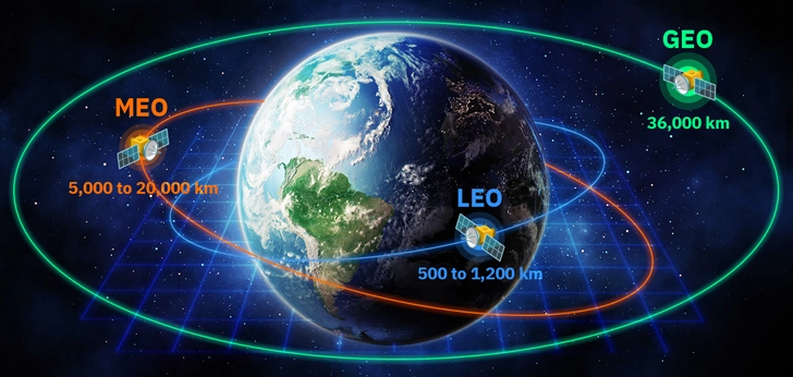
GEO Satellite Constellations
GEO stands for a geostationary (or geosynchronous equatorial) orbit that hosts hundreds of satellites nowadays. Geostationary swarms derived their name from their Earth-rotation mode: they synchronize with our planet’s movement, thus hovering all the time over the same point. It happens because GEO swarms fly over the equator, and each rotation takes 24 hours. GEO is a typical orbit for weather satellite constellations. Others broadcast TV and provide low-speed communication services.
Thanks to the altitude of 36,000 km, an individual GEO satellite can capture 40% of the Earth’s surface. Thus, a group of three units 120 angular degrees apart is enough to keep an eye on the whole world.
MEO Satellite Constellations
MEO is an acronym for medium Earth (or mid-Earth) swarms operating at the altitude of 5,000 to 20,000 km and traditionally serving for navigation purposes. MEO constellations also provide high-bandwidth connectivity in locations where terrestrial infrastructure is poor or not feasible. This particularly refers to maritime and aerospace industries, offshore platforms, and rescue team operations in remote areas.
LEO Satellite Constellations
LEO swarms make the densest space population, operating at an altitude of 500 to 1,200 km. The derived data is widely used by governmental bodies, as well as commercial and non-commercial organizations. Low Earth orbit satellite constellations primarily support research, telecommunication, and Earth Observation needs of environmental monitoring, disaster response, forestry, and agri-sector.
Such swarms may have circular or elliptical orbits . Circular orbits are at the same altitude, while elliptical orbits contain the apogee (the highest point) and the perigee (the lowest one). Swarms with circular orbits revolve around our planet within 1.5 to several hours and typically fly nearly above the geographic poles. As for elliptical orbits, they are passed slower at the apogee and faster at the perigee points.
| Parameter | GEO | MEO | LEO |
|---|---|---|---|
| Altitude | 36,000 km | 5,000 to 20,000 km | 500 to 1,200 km |
| Coverage area | Vast | Medium | Narrow |
| Downlink and uplink rate (signal speed) | Slow | Medium | Fast |
| Ground station spacing | Distant | Regional | Local |
| Antenna | Stationary | Dual-tracking | Complex tracking and terrestrial network |
EOSDA LandViewer
Access historical satellite imagery with global coverage for free, analyze them on-the-fly and download.
Why Are Satellite Swarms Important?
The first satellite constellations were launched in the 1960s, and many were deployed from the 1990s up to date. Swarms perform a number of tasks from fiber-like internet connectivity to multi-purpose Earth monitoring, obtaining quality imagery for subsequent AI-powered data procession by analytical platforms. Remote sensing data users particularly rejoice when they can buy services at affordable prices to get clear answers to their questions, and EOSDA is able to provide cost-effective and reliable solutions.
About the author:
Kateryna Sergieieva has a Ph.D. in information technologies and 15 years of experience in remote sensing. She is a Senior Scientist at EOSDA responsible for developing technologies for satellite monitoring and surface feature change detection. Kateryna is an author of over 60 scientific publications.
Recent articles

EOSDA Forecasts Yields For 2025 In Saskatchewan
EOSDA created RM-level crop yield forecasts for Saskatchewan to address limitations of official data. The project shows how satellite and weather inputs reveal local yield changes during the season.

Digital Tools Improve Soil Health And Yields In Mexico
EOSDA and ITTA supported a Guanajuato farm with contour-line planning, monitoring tools, and practical guidance to reduce soil erosion and improve yields in the long run.

Analyze 2025 & Plan Your Best Year Yet: LandViewer Christmas Offer
It’s the most wonderful time of the year! The Christmas holidays are here, and so is your chance to analyze 2025 and plan a prosperous 2026 with more affordable Pro plans in LandViewer.