False Color Satellite Imagery
A false color image is used to reveal or enhance features otherwise invisible or poorly visible to a human eye. In other words, a false color composite is a multispectral image interpretation using the standard visual RGB band range (red, green, and blue).
False Color Composite Image Schemes
False color imagery can be produced using different color combinations (schemes). The choice of a color scheme depends on the type of objects that need to be emphasized in the image.
Below, are the most common types of band (color) combinations used to create false color imagery.
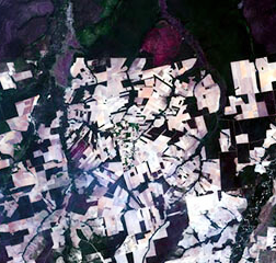
SWIR-2, SWIR-1, Red False Color Scheme
This false color combination enhances a variety of objects in the image assigning them each a specific color. Water bodies are blue or black which makes coastlines appear more distinct. Snow and ice are more easily discernible as their dark blue color stands out. Urbanized areas can appear white, gray, or purple, providing contrast with the dark green vegetation. In other words, every characteristic feature of the Earth’s surface has its unique color or shade of a color.
A false color composite produced using the SWIR-2, SWIR-1, Red scheme is also often used to detect and analyze aerosols – tiny solid or liquid particles suspended in the atmosphere (dust, soot, volcanic ash, water droplets, sea salt particles, etc.).
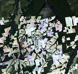
NIR, Red, Green false color scheme
Each color (band) combination can be tailored to enhance some specific object or feature type. For instance, a false color image made out of the NIR (near-infrared), Red, and Green bands, will give all the vegetation a distinct red color, allowing it to be more easily distinguished from its surroundings by the human eye. This is possible due to the high reflectance of plants in the near-infrared spectrum. Additionally, the NIR, Red, Green scheme helps to distinguish clear water (darker shade of blue) from turbid water (cyan) in a false color image.
SWIR, NIR, Red false color scheme
Combining short-wave infrared (SWIR), near-infrared (NIR), and Red bands highlights the presence of vegetation, clear-cut areas and bare soils, active fires, and smoke; in a false color image.
The scheme gives all of these objects and features unique colors:
- green for vegetation;
- purple or magenta for bare soils;
- bright red for active fires;
- light blue for smoke plumes.
How to use false color imagery
The way we see the world is very strictly determined by which wavelengths of light we can perceive. The human range is rather limited and does not allow us to see the “big picture”.
A false color image is an amazing tool that can reveal a lot of visual information otherwise hidden from us. For example, to the human eye, vegetation appears green if it’s lush and healthy, but sometimes it is harder for us to distinguish it from its surroundings, especially in urban areas. Using the natural ability of the vegetation to reflect significantly more light in the near-infrared range, we can make it appear much brighter and more distinct in a satellite image. The same goes for other objects that appear dim to us or are completely invisible.
The insights extracted from the false color imagery can help solve real-world challenges.
Such useful applications of satellite imagery might someday help us achieve a sustainable Earth.