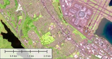
Natural Color, Pansharpen Band Combination
Pan-sharpening is a shorthand for “Panchromatic sharpening” which means using a panchromatic image to sharpen the multispectral image to increase it’s spatial. In short, we can say that pansharpening is merging both images to create a high-resolution color image. The multispectral imagery has a high spectral resolution level as compared to a panchromatic imagery, while the panchromatic image contains a high spatial resolution compared to the multispectral image. This gives the image formed from their fusion the best spectral and spatial resolution. Basically, it increases color resolution in the combination to match the resolution of the panchromatic band:
High-res grayscale band + Low-res color bands = high-res color image
Pan-sharpening follows a class of algorithms, and the common one is known as component substation which involves different steps. This includes the follows:
Up-sampling: this is the up-sampling of the color bands to match the resolution of the panchromatic band.
Alignment: the up-sampled panchromatic and color bands are aligned to decrease artifacts caused by the misregistration.
Forward transform: the up-sampled panchromatic and color bands are then converted to alternative colors-pace.
Intensity matching: the color band intensity is matched to the intensity of the pan band in transformed space.
Component substitution: there is a direct substitution of the pan band for intensity component transformed.
Reverse transformation: this is performed by substituting component intensity to transform it back to original color.
Interpretation Of Band Combination: Red, Green, Blue, Panchromatic
The spatial information in the high-res grayscale band and the multispectral color information is utilized to create the high-resolution image which brings about the ground features to appear in colors that are similar to that of the human visual system. Here healthy vegetation appears green, unhealthy vegetation yellow and brown, freshly cleared fields have a light appearance, coastlines are white and roads are gray. The band combination shows the water penetration and the bathymetric and superior sediment information. It’s also very useful for urban studies.