Australia is home to vast reserves of unconventional gas, including coal seam gas (CSG), which has been extracted at an increasing rate in recent years. However, this method of gas extraction has been linked to multiple negative consequences, with the most pressing one being soil subsidence on crop fields causing significant damage to agricultural land across the country. The problem is particularly acute in Queensland, where over 20 million hectares of farmland are at risk of subsidence due to CSG mining.
As a part of our vision to use space tech to preserve life on Earth, we continue developing our special stories of impact. In this story, we’ll delve into the issue through the lens of Ms. Zena Ronnfeldt, an Australian farmer whose field is situated next to a coal seam gas mine, and explore her endeavor to instigate nationwide changes to address this problem.
Australia’s Burgeoning Coal Seam Gas Production
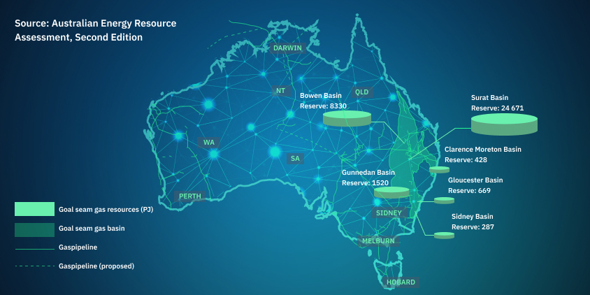
Unconventional coal seam gas production is a rapidly growing industry in Australia. Two main CSG basins – Bowen and Surat – are situated in Queensland, and gas production from there began in 1996 and 2005, respectively. The production was a result of the reduction of conventional gas production from existing fields and coincided with a Queensland government policy requiring thirteen percent of electricity to be sourced from gas-fired generation by 2005 . That requirement has been increased to 15 percent by 2010 and 18 percent by 2020 .
The process of gas extraction involves tapping into coal seams (layers of coal embedded in the earth) with the goal of extracting the methane gas trapped within. This gas is a byproduct of coal formation and is both pure and non-toxic, making it a commercially attractive energy resource.
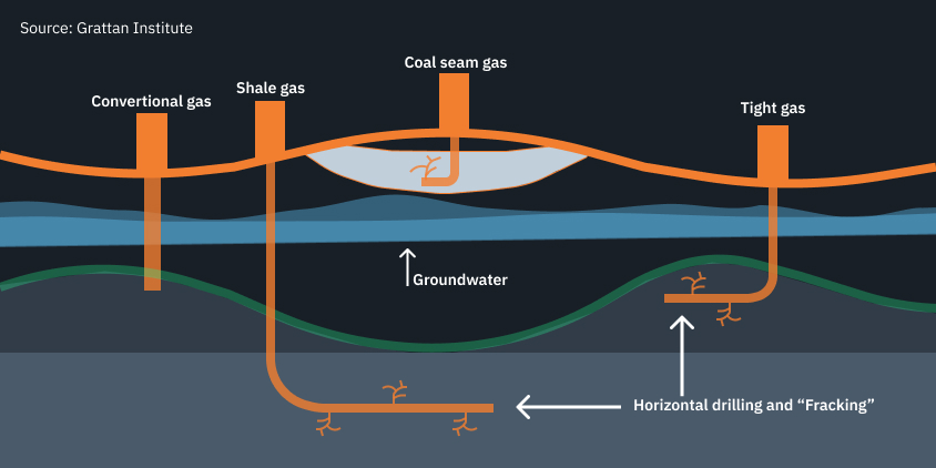
First, a well is drilled into the coal seam. Then, water gets removed from the groundwater aquifers that contain the gas to reduce the pressure within the seam and allow the gas to be captured. This removed water is known as associated water and has a high saline content, as well as other chemical constituents. Once the water is removed, the gas can be collected and processed for use .
The Environmental Impact Of Coal Seam Gas Mining
Although unconventional CSG production is a significant contributor to the energy supply in Australia, it also brings a range of negative environmental consequences.
CSG mining often involves the use of hydraulic fracturing (also known as “fracking”), a process of injecting a combination of water, sand, and chemicals into the coal seam that can lead to the contamination of groundwater with hazardous chemicals. Specifically In Queensland, Australia, there were reports of gas bubbling into the Condamine River, which may be potentially linked to nearby CSG mining activities .
A study from 2017 found that air pollution from CSG mining could pose a significant threat to public health, particularly in terms of respiratory diseases . It also contributes to greenhouse gas emissions, both through the direct release of methane during extraction and the burning of the gas for energy.
In Australia, CSG projects often require the clearing of large areas of land, which can disrupt local ecosystems, threaten wildlife and lead to habitat destruction and biodiversity loss.
Last but not least, the extraction process requires a network of production wells, pipelines, and access roads, which can significantly alter the landscape and existing land uses, predominantly agriculture. In 2016, the number of production wells was expected to reach up to 20,000 by 2030 in the eastern Australian Surat Basin and the southern Bowen Basin .
The extraction of large volumes of groundwater during the gas production process has proven to lead to a lowering of the ground surface . This alters the natural drainage patterns of a landscape and leads to increased flooding and waterlogging, which can further degrade soil quality and reduce agricultural productivity .
An aggregate analysis of revenue losses tied to individual wells disclosed that in 2016 the average revenue losses in cropping ranged from $7,500 to $16,000 per standard CSG production well .
The Regulatory Landscape Of Australia’s Coal Seam Gas Industry
So how to balance the economic benefits of resource extraction with the need to protect the environment and agricultural productivity?
In Australia, the regulation of CSG mining is primarily the responsibility of state governments, but the federal government also plays a role. The Environment Protection and Biodiversity Conservation (EPBC) Act signed back in 1999 indirectly regulates CSG development on or near agricultural land if the activity is likely to have a significant impact on a matter of national environmental significance .
In Queensland, the Gasfields Commission plays a crucial role in managing the coexistence of the CSG industry and agriculture. The Commission’s role includes advising the government on emerging issues, conducting research, and facilitating communication between landholders, communities, and the CSG industry .
The Australian government has established an adaptive management approach to mitigate the environmental risks associated with CSG projects. This approach involves monitoring impacts and making changes if those impacts cross a specified threshold.
For example, CSG projects typically have conditions which limit the drawdown of groundwater levels. If impacts to groundwater levels reach a certain proportion of that limit, the company is required to investigate the cause and take action to halt further drawdown .
Despite regulatory measures, there are still concerns about the adequacy of the current laws and standards regulating the CSG industry. There is a rising need to update national laws and standards regulating these industries due to the pronounced, cumulative impacts on Australian communities, agricultural industries, air and water quality, and the environment.
The Farmers’ Struggle For Fair Compensation
Australia’s various regulatory measures are designed to ensure that the interests of farmers are safeguarded. Under the Queensland Government’s regulatory framework, CSG companies are required to compensate landholders where it is established that mining activities have caused an impact. This applies regardless of whether there is an upfront agreement in place or there is gas infrastructure on or under a landholder’s property .
However, landholders have a limited ability to claim compensation and the corresponding process is unclear because it’s hard to predict exactly how much damage will happen and when it will occur. So, instead of deciding on a compensation amount beforehand, it’s often worked out as and when the damage happens.
It was scary to find out the Government was only regulating regional environmental matters, they had not made the CSG miner collect any data suitable to monitor impacts to farming.
The current law, the Mineral and Energy Resources (Common Provisions) Act 2014, only allows for compensation to landholders if the damage happens within the area where the CSG mining is allowed to take place. This means that if damage happens outside this area, the landholders can’t claim compensation.
In the case when a farmer is growing crops in a floodplain or has leveled their land to allow for irrigation and the land sinks due to CSG extraction, the authorities agree in their latest reports that this could cause big and permanent problems . But proving this damage was caused by CSG mining within the allowed area can be a complicated and expensive process requiring expert advice and possibly leading to legal disputes.
As of summer 2023, landholders, representatives from agricultural and resource industries, legal professionals, advocacy organizations, research institutions, and various state government agencies are actively involved in assessing the existing compensation framework . Discussions regarding potential enhancements to it are still in progress.
The Problem As Seen Through Zena Ronnfeldt’s Case
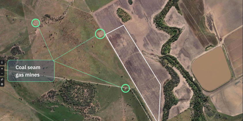
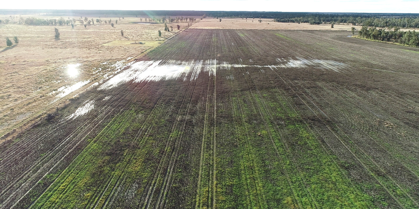
Zena Ronnfeldt’s field is situated in the Western Downs region of Queensland, between the towns of Dalby and Kogan. During the last few years, she has noticed increasing levels of moisture in the soil in some areas of her field. The changes were so dramatic that water pondages started appearing on her field during large rainfalls.
Each time, the excess of water was turning the soil into a dark, wet, and slimy morass. The waterlogged terrain was causing a patina of algae, its verdant hues sparkling against the blackness of the boggy soil. With no nutrients, nitrogen escaping, and mycorrhiza dying in the soil, farming machines were rendered helpless, bogging down in the mire with deep tracks carved into the mucky terrain.
Although the Queensland Climate Change Center of Excellence predicted an increase in rainfall events caused by climate change a decade ago , the latest data shows that drier-than-normal conditions prevailed across large parts of Queensland, including the Western Downs Region, over the period from 2013 to 2019 .
Because of that, Zena started suspecting the changes in the moisture were actually caused by soil subsidence. She also started struggling to establish crops.
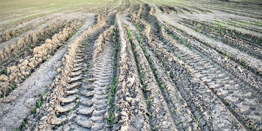
We dug water drainage channels in mid 2020 and again in late 2022 but found that other areas of the field, and the channels themselves, continued to sink unevenly causing more water pondage. In 2022 we could not grow a crop on 120 hectares and we could not control the weeds.
So she started investigating if soil subsidence was caused by CSG mining.
Her suspicions turned out to be legitimate. In fact, they were echoed in several comprehensive studies and reports that have been conducted in the region during the last few years.
One study reported the negative effects of coal seam gas mining in Queensland on soil subsidence, management of produced water, and farming overall . The 2021 report of the Office of Groundwater Impact Assessment showed that hundreds of meters of CSG depressurization around the CSG fields near Condamine Alluvium have resulted in a few centimeters of subsidence at the ground surface . One year later, another report from the same office stated the existing CSG-induced subsidence has increased from 100mm to about 120 mm in the last 18 months or so within mature gas fields near the Condamine Alluvium .
Because of that, attitudes toward CSG development among the local communities have become more polarized over time, with a growing concern about the impacts of CSG development .
At the same time, Zena was engaging in field research.
The most effective way to confirm soil subsidence is using ground-based instrumental research methods. Techniques such as tacheometric surveys offer high vertical and horizontal accuracy in measuring individual points, and advanced LIDAR surveys may yield suitably precise data.
However, to validate that soil subsidence has been ongoing for years in such a way, these techniques would have needed to be implemented much earlier. Instead, Zena plans to test the soil.
By undertaking soil tests in both the sunken areas and the unaffected sections of her field, she will be able to compare changes over time, particularly as fertilizer has been uniformly applied over the last seven years. This method of monitoring will assist Zena to identify disparities in nutrient content resulting from subsidence.
Spurred on by concerns raised from similar tests done by a local farmer, Zena will also undertake additional tests for hydrocarbons and BTEX (benzene, toluene, ethylbenzene, and xylene – volatile organic compounds found in petroleum products). These tests have the potential to expose a correlation between the CSG mining activities and the appearance of harmful compounds in her soils.
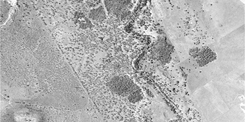
Apart from that, she has been collecting historical data from sources such as old satellite images, aerial photos, and UAV photography, to gather useful insights.
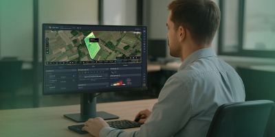
Searching for other ways to show the water drainage in my field had changed after the CSG wells started, I found the EOS Data Analytics crop monitoring platform had ‘eyes in the sky’ looking at soil moisture changes during the time period I needed.
As per Zena’s request, EOSDA scientists initiated an investigation of their own to see if satellite data analytics can be of any help to her.
Assessing Soil Subsidence With Remote Sensing
While optical satellite data analytics does not directly support gas detection in mining, it can still provide indirect information relevant to assessing mining-related activity.
In some cases, soil subsidence (and soil compression caused by it) leads to an increase in soil moisture. When the ground subsides, it can alter the natural drainage patterns and cause water to pool in the subsided areas. This can be particularly noticeable after rainfall events.
To track soil moisture levels via satellite imagery, we decided to use an online satellite-based precision agriculture platform for crop monitoring. Among other features, EOSDA Crop Monitoring allows studying the NDMI dynamics. The Normalized Difference Moisture Index (NDMI) is a remote sensing technique used to assess vegetation moisture content and water stress. Areas of higher NDMI values may indicate regions of higher soil moisture potentially due to subsidence.
The video above reveals that with each year it takes more and more time for the soil to drain the water, and that is the reason Zena was forced to dig drainage channels to speed up the process at some point.
To figure out if these NDMI maps reveal abnormal soil moisture levels, EOSDA scientists needed to compare them with the previous drainage patterns.

For that, a publicly available digital elevation model was used. It shows that relief in the area of Zena’s field tends to slope to the east and northeast, forming the existing system of watercourses which ensure unimpeded water outflow. The model also reveals any subsidence of the surface in the middle part of the western side of the site may lead to the formation of a network of drainless depressions.
Comparing the NDMI dynamics of the field with its hydrological model, we can now notice a change in moisture accumulation in the western and southern parts of the field caused by soil subsidence.
Proving that subsidence in this specific case results from the coal seam gas mining process nearby is out of the scope of the possibilities offered by the optical satellite data analytics tools.
Eventually, we reported to Zena that indirectly and, most likely, the NDMI-based technology allows for establishing the change in the dynamics of moisture in the soil, but satellite data can’t be sufficient to prove in the Court that it is caused exactly by coal seam gas mining nearby.
In the case of SAR satellite technologies, a 2022 report published by Geoscience Australia reveals that they were used to detect soil subsidence of up to 100 mm in Surat Basin, where Zena’s field is situated. Its relation to coal seam gas mining is proved by the fact that the focus areas of broadly negative ground motion velocities (i.e., indicating subsidence) coincide with coal seam gas extraction wells .
Meanwhile, Zena utilized the OGIA LiDAR tool to collect more data. LiDAR, which stands for Light Detection and Ranging, is another remote sensing method that uses light in the form of a pulsed laser to measure distances to the Earth. In this case, the LiDAR data was collected by an airplane flying about 2.5 km over the surface. The tool provides an additional layer of data to highlight soil irregularities that may be attributed to subsidence.
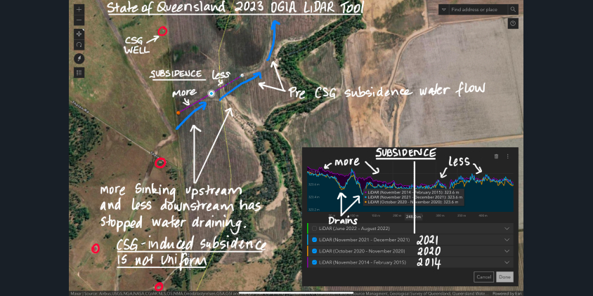
The accuracy of this LiDAR is at a 1×1-meter resolution within +/-70mm or +/-50mm at 68% confidence level, but the data collected using this tool has its drawbacks, especially when applied to heavily vegetated or wet fields like Zena’s, where the intricate patterns of beds and furrows could cause significant data distortion. The high level of vegetation or crop stubble could also prevent the LiDAR beam from reflecting accurately off the soil, further hampering its utility.
Despite these challenges, Zena discovered that LiDAR data could play a significant role in substantiating the case for subsidence – but only when used in conjunction with other forms of data. The LiDAR tool alone would struggle to accurately identify areas of subsidence in a rain-grown field, but when paired with the NDMI maps and aerial photographs, it begins to form a clearer and more credible picture.
When Changing The World Requires Thinking Outside The Farm
Zena has gathered a wealth of information proving that the soil subsidence on her field is a direct consequence of nearby coal seam gas mining started in November 2012. Her next step could be seeking compensation for the losses she has incurred due to it in Court.
But, as stated before, the compensation frameworks in her situation still require considerable refinement for optimization, if they exist at all in her case. So her vision extends far beyond her own farm.
With her quest being a reflection of a broader concern shared by the farming community about the future of their land and livelihoods, she aspires to establish a legislative mechanism out of her case that would enable farmers to request compensation in a straightforward manner.
As farmers we enjoy what we do and it is the thought that you are feeding people and clothing people that keeps you going in the hard times like droughts and hail storms. But we must leave our farms in a better state than when we bought them, as that is our responsibility to future generations.
As an intermediate result of her efforts, Zena was able to provide her criticism to the findings of the GasFields Commission Queensland. Consequently, she successfully influenced the Commission to admit the risk of permanent negative consequences from CSG mining on nearby fields in its final report.
For the EOSDA team, Zena Ronnfeldt’s journey is a testament to the power of individual action in the face of systemic challenges. It is a reminder that each of us has a role to play in safeguarding our environment and ensuring the sustainability of our agricultural practices.
We are immensely proud that our technology is a catalyst for sustainable farming, a testament to our company’s ethos. Farmers like Zena, who utilize technologies like ours to examine their fields and improve countrywide regulations to take better care of the soil, inspire us greatly. Their dedication to sustainability gives meaning to our work and fuels our commitment to innovation for the betterment of our planet.
When it comes to our environment, every action counts, and every voice matters.
This Story of Impact was created following EOSDA’s vision to make space tech a global driver of sustainability on Earth. If you wish to share a story that relates to this idea and believe our solutions can help develop it, please contact us via pr@eosda.com.
About the author:
Maksym Sushchuk is at the forefront of realizing EOSDA's vision to make space tech a global driver of sustainability on Earth. He has over 15 years of experience in journalism and content creation for prominent Ukrainian startups, charitable funds and ESG businesses. As Head and Co-founder of PR Army Maxim brings attention to the human and social tolls of the aggression against Ukraine.
Turn high-tech satellite data into actionable solutions for your business.
More news
Agriculture In Chiapas Takes Regenerative Path Forward
With over 30% of the nation's agricultural output, Chiapas, Mexico faces challenges from outdated practices. Learn how regenerative methods are paving a sustainable future for the region.
Life After Kakhovka Dam Destruction: A New Beginning
The dam’s destruction flooded numerous villages and farmlands, but as the water receded, nature began to restore itself in the area known as the Great Meadow.
Heather Wildman Helps UK Farmers Secure Their Future
Learn how Heather Wildman’s work in UK farm succession planning has transformed many farming families’ futures. Her empathetic approach ensures farms thrive across generations.