Straddling the boundary between Kazakhstan and Uzbekistan, the Aral Sea’s tragic decline due to misguided irrigation projects led to a loss of biodiversity, economic hardship, and health challenges for the local population.
As a part of our vision to use space tech to preserve life on Earth, we continue developing special stories of impact. This time, EOSDA delves into the multifaceted efforts to revive the Aral Sea, with a focus on the United States Agency for International Development’s (USAID) innovative Environmental Restoration of the Aral Sea (ERAS-I) project and the ways satellite monitoring can be an aid in tracking its progress.
By weaving together science, innovation, and human compassion, the restoration of the Aral Sea illuminates a path towards a harmonious and sustainable future, enriching the lives of generations to come and nurturing a legacy where nature and humanity thrive in unison.
Restoring Aral Sea with saxaul afforestation. Source: EOS Data Analytics
The Jewel Of Central Asia
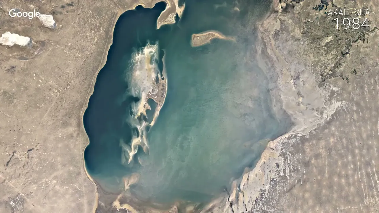
The Aral Sea, once a majestic jewel in the heart of Central Asia, straddled the boundary between Kazakhstan and Uzbekistan. As the world’s fourth-largest saltwater lake, it spanned 63,000 square kilometers up to the late 20th century .
Its name, translated from Kazakh and Uzbek, means “Sea of Islands,” a poetic reference to the more than 1,100 islands that once dotted its waters, resonating with the region’s rich history.
Geographically significant, the Aral Sea was nestled in the climatically inhospitable area of Central Asia, east of the Caspian Sea. It stretched almost 435 km from north to south and over 290 km from east to west, a vast expanse that once teemed with life.
The shores of the Aral Sea were indented by bays in the north and interrupted by the deltas of the Syr Darya and Amu Darya rivers. The eastern shores, a wide tract of shallow water, were a haven for aquatic life, reflecting the lake’s rich biodiversity.
But then, the vibrant ecosystem began to wither, and the Aral Sea’s majesty was lost.
The Dark Shadow Of White Gold
In the 20th century, the Soviet government harbored a vision to transform the arid lands of Central Asia into fertile fields. Cotton, dubbed the “white gold,” was the goal, promising wealth and prosperity. To achieve this, they diverted the rivers feeding the Aral Sea to irrigate the fields.
The consequences were immediate and devastating. By the 1980s, the two great rivers that sustained the Aral Sea virtually dried up during the summer months, unable to reach the lake. The lake’s waters, now unreplenished, began to evaporate rapidly. By 1989, the once-unified lake had receded to form two separate parts, each with a salinity almost triple that of the sea in the 1950s .
The decline continued, and by 1992, the total area of the two parts of the Aral Sea had been reduced to approximately 33,700 square kilometers, with the mean surface level dropping by about 15 meters.
Eventually, the once-majestic lake transformed into a symbol of environmental tragedy.
USAID’s cooperation with the Executive Director of the International Fund for Saving the Aral Sea (ED-IFAS) and regional experts is generating knowledge about best practices for afforestation and sharing these results with other groups to find the most effective means for restoration. Through these collaborations, USAID focuses on support and innovation for effective transboundary cooperation to combat climate change with appropriate mitigation and adaptation measures. Our work will help restore the dry bottom of the Aral Sea as a collaborative endeavor with local, national, and regional stakeholders and governments.
The Toxic Legacy Of The Aral Sea’s Decline
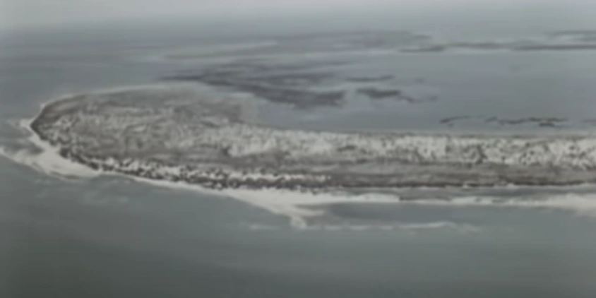
By 2007, the Aral Sea had declined to just 10% of its original size, fragmenting into four lakes: the North Aral Sea, the eastern and western basins of what was once the far larger South Aral Sea, and the smaller intermediate Barsakelmes Lake. By 2009, the southeastern lake had vanished, leaving the southwestern lake a mere thin strip at the western edge of the former southern sea.
In August 2014, a startling revelation came from NASA satellite images: the eastern basin of the Aral Sea had completely dried up, giving birth to what is now known as the Aralkum Desert.
The Aral Sea deterioration in 2000-2018 as seen through NASA satellites. Credit: NASA Earth observatory
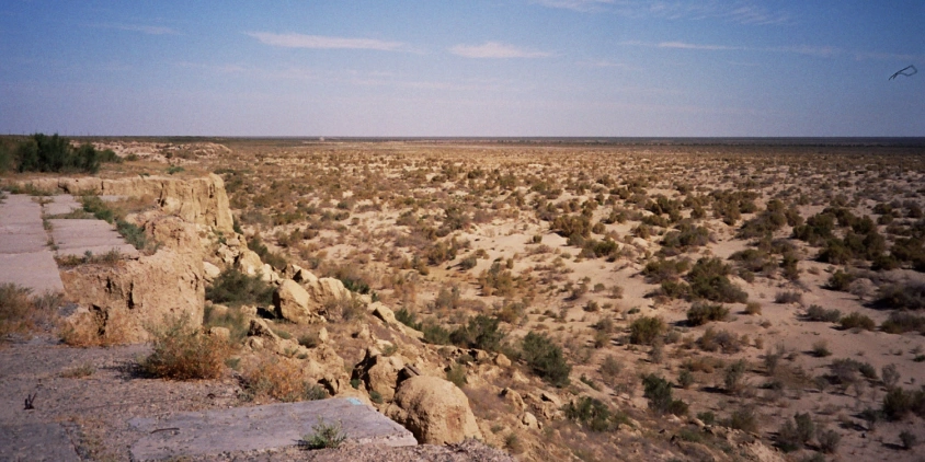
The consequences of this transformation have been profound and far-reaching. The region’s once-thriving fishing industry lies in ruins, leading to economic hardship, unemployment, and mental health challenges for the local population . The increased salinity and drying of the lake resulted in the local extinction of several fish species, including the Aral trout, Turkestan barbel, and all sturgeon species.
But the damage extends beyond the water’s edge. The drying of the Aral Sea exposed a seabed contaminated with pesticides and other chemicals. Winds now carry these toxic particles into the air, causing respiratory problems among the local population.
Furthermore, the diverted water from the Syr Darya river, used for decades to irrigate about two million hectares of farmland in the Ferghana Valley, contains pesticides and fertilizers. These were added to compensate for soil deficiencies caused by cotton farming. The decrease in water quality has led to the spread of diseases such as typhoid and hepatitis among locals .
Even in the face of such tragedy, there is still hope.
From Desolation To Rebirth
Several restoration initiatives have been aimed at restoring the Aral Sea.
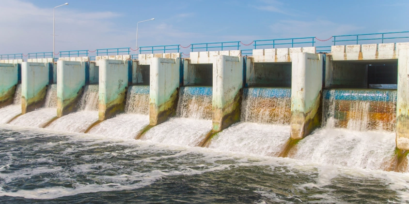
According to the Chinese Academy of Sciences, the shrinkage rate of the Aral Sea has slowed since 2005 . This change is partly attributed to Kazakhstan’s completion of the Kok-Aral Dike and Dam in 2005. Situated between the northern and southern parts of the Aral Sea, the dam now separates the two water bodies, preventing flow from the North Aral into the lower-elevation South Aral. This intervention led to a reduction in salinity and a revival of the local fishing industry .
Further efforts have focused on reducing the water’s mineralization in the Aral Sea, a move that has helped return more than 20 fish species to its northern part . Local governments are considering various laws to protect the area, and scientist groups are conducting assessments and studies to identify restoration approaches. These include soil sampling and examination of possible pilot sites for rehabilitation.
However, among these initiatives, one project stands out: USAID’s Environmental Restoration of the Aral Sea. EOS Data Analytics highlights it as the most prominent effort in the ongoing battle to reclaim the Aral Sea’s former glory.
Planting Hope In The Aral Sea’s Dried Bottom
On May 19, 2021, the UN General Assembly designated the Aral Sea region as a “zone of ecological innovations and technologies.” Both the presidents of Kazakhstan and Uzbekistan committed to restoring three million hectares of the dried Aral Sea bottom through afforestation, with Kazakhstan pledging to afforest 1.3 million hectares by 2030. To guide this effort, the government partnered with USAID to develop an assessment and action plan, leading to the ERAS-I and Oasis afforestation projects.
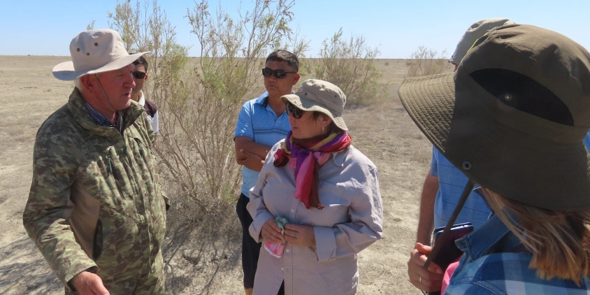
The USAID ERAS-I Activity is a collaboration with local state authorities, including the Ministry of Ecology and Natural Resources of the Republic of Kazakhstan and the Executive Directorate of the International Fund for Saving the Aral Sea (ED IFAS) in Kazakhstan. The project aims to pilot promising afforestation methods on the dried bottom of the Aral Sea, about 50 kilometers from the nearest village of Karateren. This area’s soil is representative of a large portion of the dried bottom of the Kazakhstan part of the Aral Sea.
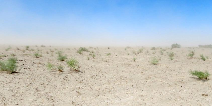
A key component of the ERAS-I project is the planting of black saxaul, a hardy shrub endemic to Central Asia. Known for its deep roots, black saxaul improves soil quality by reducing salinity and increasing organic matter content. It also holds tremendous amounts of sand in its root, reducing debris and airborne particles. When fully grown, these shrubs reach heights of six meters, appearing more like trees and creating a natural barrier against sandstorms while providing cover for other endemic flora and fauna.
The ERAS-I project began with the “Oasis” method of afforestation, laying out smaller plots in a checkerboard style. As initial plants mature, new seedlings are expected to spread, take root, and grow. Furrows are cut between plants to soften the soil, increasing the likelihood of seeds taking root.
The results of this project are anticipated to provide valuable insights into best practices for afforestation, which USAID will share with the governments of Kazakhstan and Uzbekistan, as well as other regional afforestation and restoration projects.
To plant the 200,000 seedlings purchased from local vendors, the project involves community members, addressing challenges such as the remoteness of the territory, limited infrastructure, and lack of practical knowledge. USAID also collaborates with other organizations and government agencies to pool knowledge, expertise, and resources.
Tracking The Aral Sea’s Green Transformation
To understand the afforestation efforts around the Aral Sea, it’s essential to recognize how this process contributes to restoring the lake.
Planting trees, such as black saxaul, stabilizes the soil and reduces erosion. By retaining moisture and nutrients, these plants prevent further land degradation around the Aral Sea. They also enhance water infiltration and retention in the soil, promoting groundwater recharge. This increase in the water table can lead to the replenishment of local water bodies, including the Aral Sea.
Satellite monitoring can be crucial in tracking these afforestation efforts. Through various satellite data and indices, such as NDMI and MSAVI, changes in vegetation cover, soil moisture, and other environmental factors can be observed over time. High-resolution imagery can detect even subtle changes in plant growth and soil quality, providing timely and accurate information. This monitoring enables ongoing assessment of afforestation success, identifies areas needing intervention, and ensures that restoration efforts are on track to achieve long-term goals.
In the case of ERAS-I, key performance indicators include the number of hectares planted and the survival rates of seedlings. Satellite monitoring can assist with these metrics in the future. However, as of summer 2023, the afforestation efforts are barely visible via satellites, and limited progress can be seen on images retrieved via EOSDA LandViewer, a platform for satellite imagery search and analysis in rea-time.
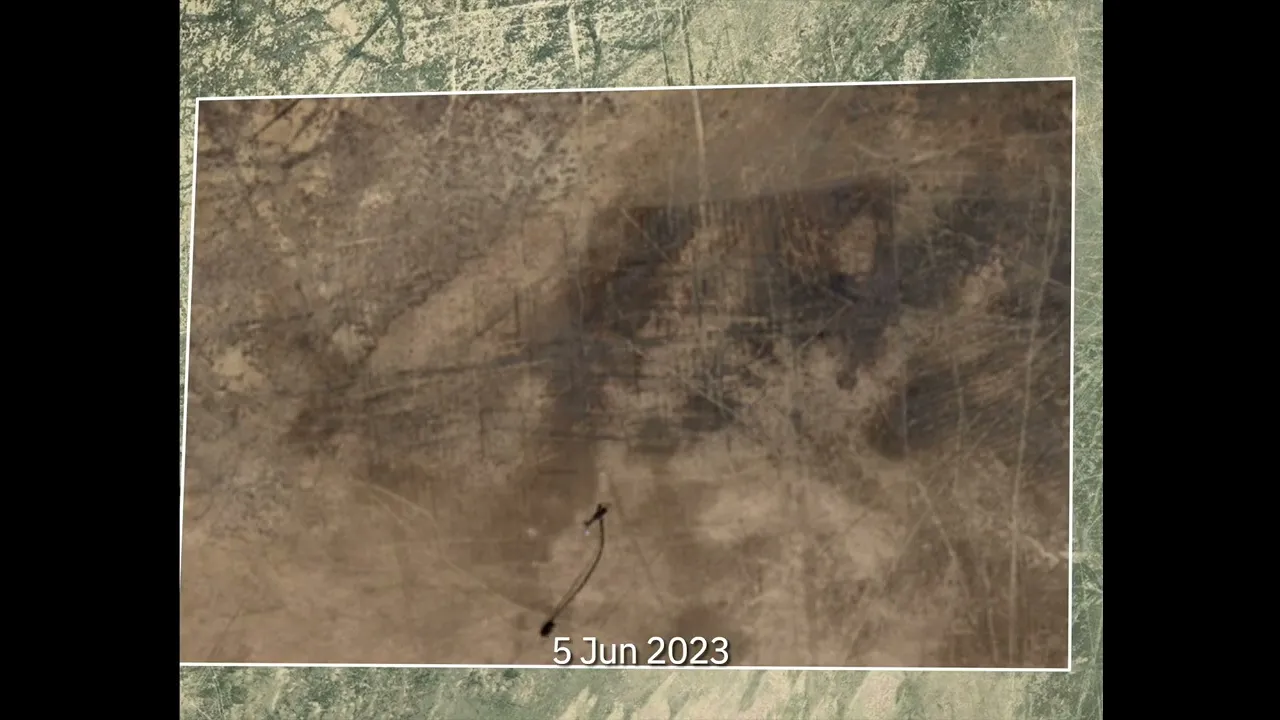
Sentinel-2 Satellite images of the OASIS saxaul plantation throughout the first half of 2023. Images used were taken on February 17 and 25, May 23, June 5 and 20, July 7, 20, and 22, and August 11. Animation: EOS Data Analytics
The animation above shows an area of 500 ha planted with saxauls. While there’s little change during the first half of 2023, an irrigation line appears to have been created on its southern side, with a water source emerging in the southwest. Presumably, a man-made basin was established, expected to provide irrigation water for the saxaul garden soon.
EOS Data Analytics has developed a specialized band combinations to track afforestation efforts within EOSDA LandViewer. Since black saxaul is a shrub and was seeded recently, it is more appropriate to track its changes using indices such as NDMI and MSAVI.
Throughout 2023, the area, situated in a harsh desert with minimal precipitation, shows slow but steady progress in the growth of saxauls, as indicated by the MSAVI dynamics below.
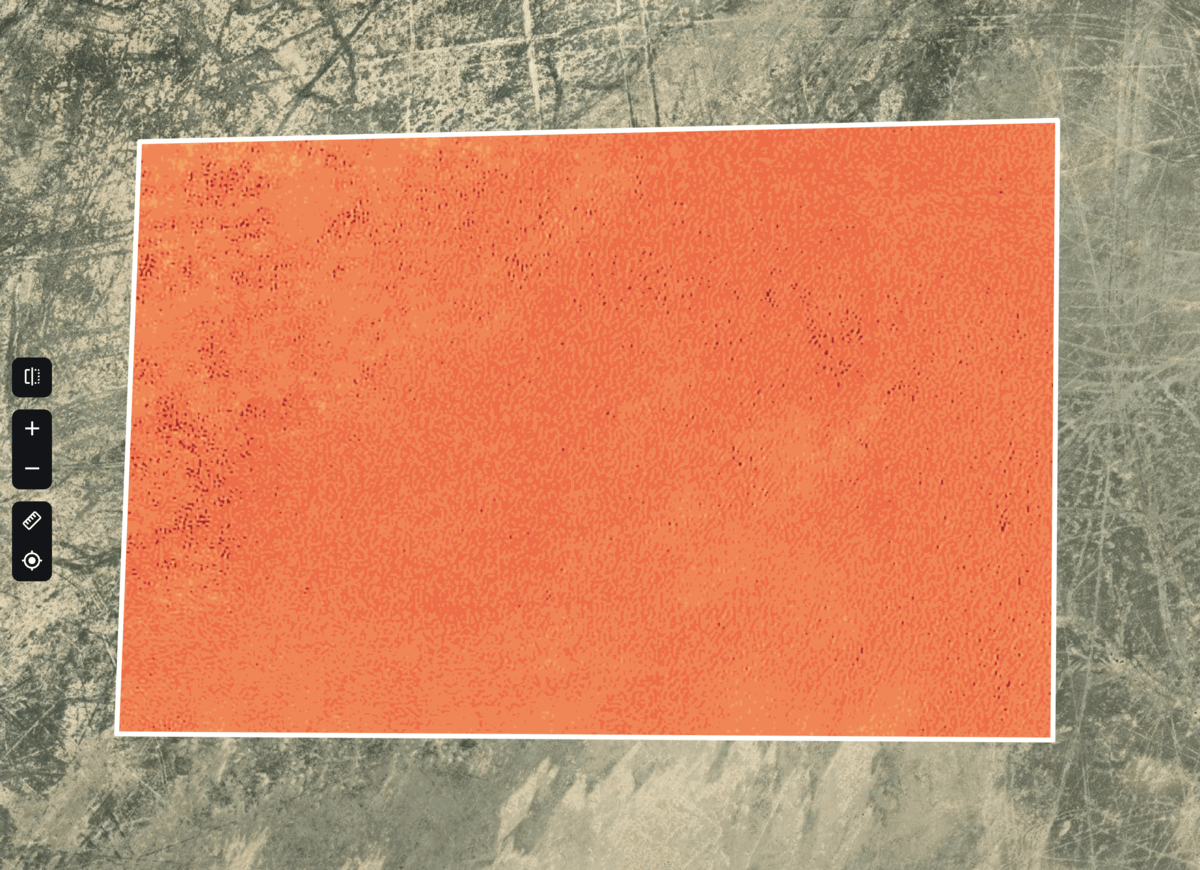
MSAVI, or Modified Soil Adjusted Vegetation Index, is one of the remote sensing indices used to assess and monitor vegetation health and cover.
MSAVI is specifically designed to minimize the influence of soil background, allowing for more accurate detection of vegetation changes. In the context of the Aral Sea’s restoration, MSAVI provides valuable insights into the growth and health of newly planted vegetation, such as black saxaul, by analyzing satellite imagery.
MSAVI can be most helpful in tracking the progress of afforestation efforts and contributes to the overall understanding of the restoration’s success. However, it takes at least two years for a black saxaul to reach a height of 30-40 cm, making the area noticeable enough for satellite tracking of vegetation and moisture changes. Hence more representative insights are expected to appear in EOSDA satellite monitoring platform as the shrubs continue to grow.
A New Horizon For The Aral Sea
The progress with ERAS-I has inspired the launch of ERAS-II . Initiated in September 2022, this new project shifts focus to the Uzbek side of the Aral Sea. In collaboration with the Uzbek government, the USAID team will test not only black saxaul but also a variety of other shrubs and agro-biotechnologies to explore their potential in restoring the dried seabed.
The USAID ERAS-II Activity in Uzbekistan is designed to operate in three distinct environments:
- In a highly saline environment, where innovative solutions will be tested to reduce or mitigate soil salinity.
- In a former shoreline with existing agricultural activity, where innovative methods will be explored to achieve more with fewer resources and effort.
- In a stable and economically viable pilot territory, where innovative agribusiness solutions will be assessed for their effectiveness and financial attractiveness.
These efforts are aimed at mitigating the negative effects of climate change and the shrinking of the Aral Sea, all while supporting local communities and enhancing their well-being.
In addition to these initiatives, ERAS-II will provide technical assistance and guidance to parties involved in addressing the challenges of drought, land degradation, and desertification in the Aral Sea Region.
The team at EOS Data Analytics looks forward to reporting on the progress of these efforts in its future stories of impact.
The Aral Sea’s Rebirth As A Guiding Light For Large-Scale Environmental Sustainability
The restoration of the Aral Sea is a beacon of hope and a symbol of resilience. It underscores the vital importance of local expertise, diverse restoration techniques, and international cooperation. The ERAS-I and ERAS-II projects, in collaboration with the Uzbek and Kazakh governments, are not just about healing a region but fostering a global commitment to environmental sustainability.
The Aral Sea restoration is a step towards a world where nature and humanity thrive in harmony, nurturing a sustainable legacy for generations to come. It is a reminder that every effort counts and every partnership matters.
The collaboration of multiple organizations and countries in the Aral Sea restoration projects illuminates a path for future environmental endeavors, demonstrating the transformative power of united action. The anticipated socio-economic benefits, encompassing improved livelihoods, sustainable land use, and ecotourism opportunities, weave the impact of these efforts into the very heart of community life. As a result, the wisdom gleaned from ERAS-I and ERAS-II reaches far beyond the shores of the Aral Sea, providing a guiding light for building a harmonious and sustainable future that will enrich the lives of generations to come.
These restoration efforts align with EOSDA’s vision for a sustainable future, emphasizing community engagement, social cohesion, and resilience to climate change. The projects are planting seeds for improved livelihoods, sustainable land use, and ecotourism opportunities, extending their impact beyond the Aral Sea.
This Story of Impact was created following EOSDA’s vision to make space tech a global driver of sustainability on Earth. If you wish to share a story that relates to this idea and believe our solutions can help develop it, please contact us via pr@eosda.com.
About the author:
Maksym Sushchuk is at the forefront of realizing EOSDA's vision to make space tech a global driver of sustainability on Earth. He has over 15 years of experience in journalism and content creation for prominent Ukrainian startups, charitable funds and ESG businesses. As Head and Co-founder of PR Army Maxim brings attention to the human and social tolls of the aggression against Ukraine.
More news
Agriculture In Chiapas Takes Regenerative Path Forward
With over 30% of the nation's agricultural output, Chiapas, Mexico faces challenges from outdated practices. Learn how regenerative methods are paving a sustainable future for the region.
Life After Kakhovka Dam Destruction: A New Beginning
The dam’s destruction flooded numerous villages and farmlands, but as the water receded, nature began to restore itself in the area known as the Great Meadow.
Heather Wildman Helps UK Farmers Secure Their Future
Learn how Heather Wildman’s work in UK farm succession planning has transformed many farming families’ futures. Her empathetic approach ensures farms thrive across generations.