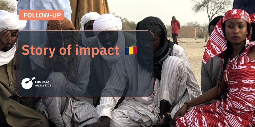
In this compelling follow-up to last year’s story on participatory mapping in Chad and EOSDA’s contribution to this project, we venture deeper into the transformative work led by Hindou Oumarou Ibrahim, a visionary at the forefront of environmental activism and social justice. Her mapping projects offer a roadmap for communities in Chad – and soon worldwide – to navigate the complexities of climate change.
At EOS Data Analytics, we are committed to the belief that space technology can be a driver for global sustainability. By spotlighting Hindou’s groundbreaking work, we aim to showcase how innovative mapping techniques can offer actionable insights that not only halt environmental degradation locally but also inspire worldwide initiatives.
This story is an outcome of our interview with Hindou Oumarou Ibrahim that unveils her global ambitions and how her relentless efforts are making a tangible impact on climate change across the globe. Join us as we explore the next chapter in this remarkable journey towards a more sustainable and just world possible thanks to modern satellite technologies.
One Woman, Hundreds Of Communities
Hindou Oumarou Ibrahim’s journey into participatory mapping began in Gabon, where she was involved in a small-scale 3D mapping project covering a mere 25 square kilometers. Recognizing the unique power of maps to transcend linguistic and cultural barriers, she saw them as dynamic, universally comprehensible tools that could assert indigenous rights and manage lands effectively. Sensing the potential for something greater, she thought, “I can do bigger than this.”
Ten years later, she spearheaded a mapping project in Baïbokoum, Chad, that was twice the size of the original Gabon map . Over time, her projects have grown exponentially, now covering areas 200 times larger than her first endeavor.
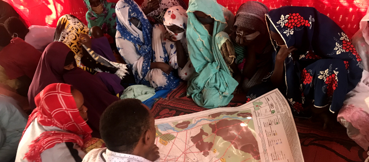
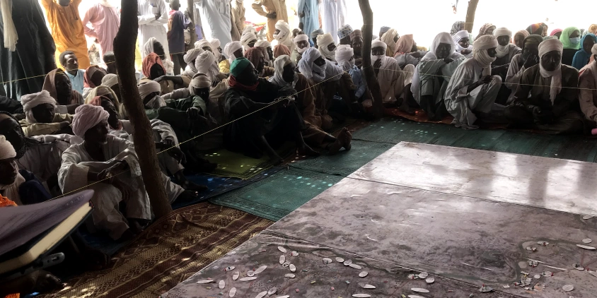
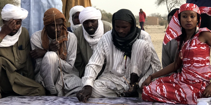
The scale of these projects is not the only challenge. In regions like Mayo-Kebbi Est and Lake Chad, hundreds of communities are involved, each with their own needs, expectations, and languages. The negotiation process is complex, requiring translations through many languages to ensure everyone understands the same thing. Despite the linguistic diversity — dozens of languages at least — the communities are organized. They have chiefs who can speak on their behalf, making it easier to reach a consensus on mitigating climate change impacts, resolving conflicts over natural resources, and preserving traditional knowledge .
The maps themselves are not static; they evolve. They start as physical maps, printed on a large scale, but they are digitized and updated over time. This allows for the preservation and growth of community knowledge, making these maps living documents that adapt to changing circumstances.
The government of Chad has been notably supportive of these initiatives. When Hindou informed them that she would be using satellite imagery for mapping, they were enthusiastic. They facilitate her work by informing local authorities of her activities, and national authorities even attend the ceremonies where the completed maps are presented by the communities themselves.
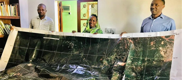
The technical aspects are equally impressive. Hindou collaborates with scientists, technicians and companies like EOSDA, recognizing the environmental and societal benefits of her work . For instance, the satellite images EOSDA’s GIS experts provide and analyze are then processed and printed, sometimes in sizes as large as five by four meters, before being taken to the communities for a several-week mapping process.
Hindou is a driving force for progress in Africa and the fight against climate change. Our joint work in utilizing space solutions proves that we’re moving in the right direction.
And it all started with a simple thought in Gabon: “I can do bigger than this.” Indeed, she has.
How Bongor Is Redrawing Its Future
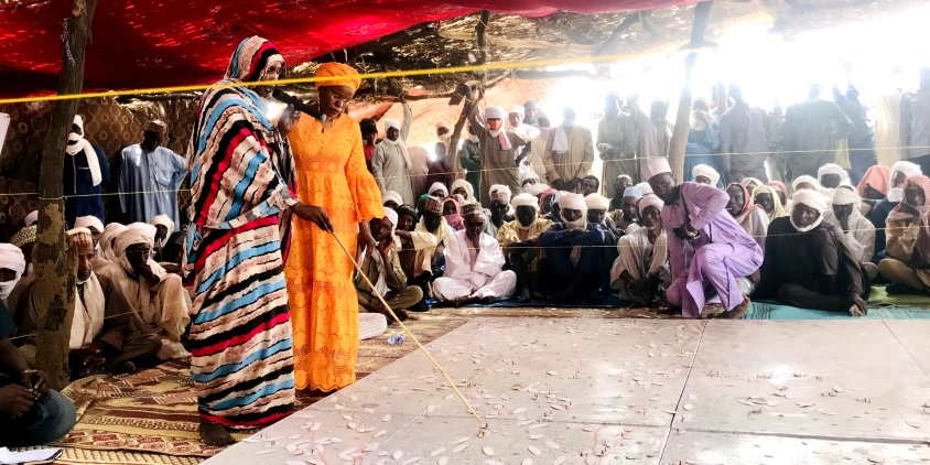
Since the inception of the participatory mapping project in Bongor, the capital of Chad’s Mayo-Kebbi Est region , there has been remarkable progress that goes beyond mere cartography.
After the initial 2D mapping, the team digitalized the map and returned to the communities to establish conventions. These were comprehensive agreements consisting of 20 articles and three chapters, all mutually agreed upon. The map was translated in two languages: Fulfulde for most local indigenous communities and French for others. These conventions now serve as a guide for the communities to manage and share natural resources effectively.
The communities didn’t just stop at agreements but also took actionable steps. They opened animal corridors and clearly defined agricultural areas, thereby mitigating conflicts over land use. Now, if a dispute arises, it’s much easier to identify who is at fault, thanks to the clarity provided by the map.
The conventions also led to the creation of a roadmap for future activities. This includes ambitious plans like reforestation, restoring lost biodiversity, and water conservation projects. The map serves as a reference point, guiding the communities in making informed decisions for these activities.
The map is a living document, open to updates and changes. Whether it’s the construction of a new road or the growth of a forest, the digital map can be modified to reflect these changes, making it a continually valuable resource.
Today, the Bongor project is not just about drawing lines on paper, but about redrawing the future of a community. Serving as a blueprint for sustainable development and harmonious living, it proves that when technology meets community wisdom, transformative change is possible.
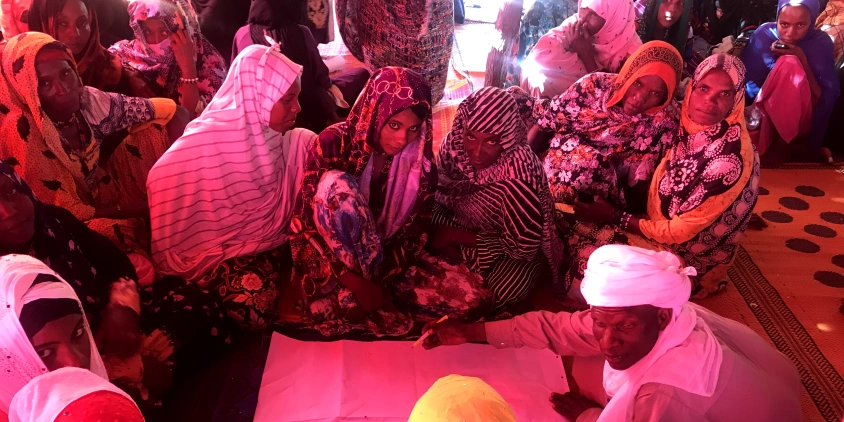
A New Chapter For Bongor Women
In a society traditionally dominated by men, the participatory mapping project in Mayo-Kebbi Est has ushered in a transformative change. One of the most significant outcomes has been the inclusion of women in the decision-making process, particularly in land management. And this shift is a practical change that’s already showing promising results.
Before, men managed large tracts of land individually, often acting in isolation within the community’s collective land. Women, on the other hand, were confined to small-scale agriculture, usually just behind their homes. They had no rights to manage or own larger pieces of land. But now, women in Bongor have been granted the right to manage significant plots of land, and they’re doing it differently – collectively.
Unlike men who work solo, women in Bongor have come together for collective harvesting. They pool their expertise and knowledge, ensuring that no one damages the land and that it remains productive for future generations. This collective approach has not only led to better land management but also to a different kind of value creation.
The women have organized themselves, setting up a bureau complete with a president, vice president, and managers. They’re now working on getting tricycles — small, community-adapted vehicles — to help them sell their produce. While men have traditionally sold their produce seasonally and locally, women are looking to expand their reach and access broader markets.
The Bongor women’s newfound rights and collective approach to land management are setting a precedent, proving that when women are empowered, communities no longer survive; they thrive.
With newly-opened opportunities, women in Mayo-Kebbi Est want not only to get financial revenue from their efforts but to reinvest it into their further prosperity. They plan to use the additional income to send their children to school and take care of their families, thereby building a stronger, more resilient community.
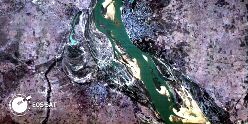
Lake Chad: Charting New Waters In Community Mapping
After the success in Bongor, Hindou Oumarou Ibrahim initiated participatory mapping of the surroundings of Lake Chad, a significantly larger area covering more than 20 villages, 50 islands, and 250 nomadic stopping points. This time, the scale is grander, the stakes are higher, and the challenges are more complex.
Life around Lake Chad is a constant flow of movement, especially for the nomadic communities that inhabit the area. Unlike settled villages, these nomadic groups set up temporary stopping points around villages. These stopping points are crucial for their way of life and are often situated near essential village amenities like markets, mosques, and hospitals.
When it comes to life milestones like death, the nomadic communities rely on the cemeteries in nearby villages. The location of the burial depends on their current stopping point, emphasizing the interconnectedness between the nomadic and settled communities. Education for nomadic children is a more complex issue. While there are specialized schools designed to cater to their mobile lifestyle, the majority of nomadic children do not attend school, making this a critical area for future development.
Hence the need to map this unique ecosystem together with all the areas the local communities frequent and have plans for.
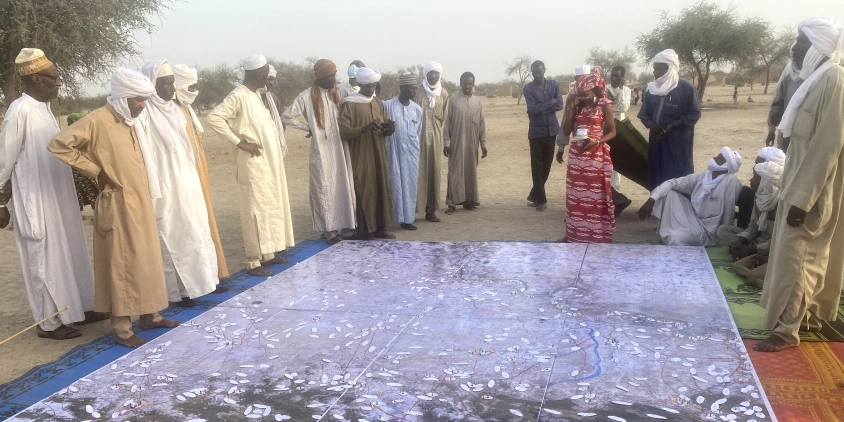
The mapping process itself is a blend of technology and local wisdom. Satellite images retrieved from EOSDA LandViewer, a tool allowing for on-the-fly searching, visualizing, and processing of satellite data, serve as the base layer, but they only tell part of the story. The communities add their invaluable local knowledge to these images, identifying everything from seasonal lakes to weekly markets. This results in a map rich in data, capturing the dynamic nature of the region.
Lake Chad also faces conflicts over natural resources . The map will serve as an impartial mediator, helping communities identify and resolve these conflicts. For instance, it is expected to help reopen corridors for pastoralists, who often find their routes blocked by individual landowners. The aim is to create conventions, similar to those in Bongor, to facilitate peaceful coexistence and resource sharing.
With the map as a reference, it also becomes easier for authorities to mediate and resolve conflicts, ensuring that the project’s impact goes beyond the communities to influence policy and governance .
By plotting this map, local communities around Lake Chad plot a course for sustainable development, conflict resolution, and community resilience.
Forgotten Lands Are Also To Be Mapped
As Hindou Oumarou Ibrahim looks to the future, her eyes are set on a new mapping project in the Chari Baguirmi region located in the heart of Chad. This area, situated south of Boussou, near the Chari river, is a landlocked region teeming with untapped natural resources. However, it’s also a place marred by conflicts and largely overlooked in terms of development.
The local communities’ struggles are palpable. In this 21st-century world, women in this area still lack proper clothing, wearing only the most basic garments. Many residents don’t even possess birth certificates, living and dying without ever becoming citizens of any country. These are people who have been left behind in almost every sense – socially, economically, and even existentially.
But Hindou sees potential amid these challenges. These communities are the most vulnerable, lacking access to basic necessities like education and healthcare, let alone climate solutions. Yet, they are the stewards of rich natural resources, and their sustainable management could be a key to resolving conflicts and fostering development.
The new mapping project aims to change this narrative. By working closely with these communities, Hindou plans to create another participatory map that could serve as a catalyst for sustainable development and conflict resolution.
The Chari Baguirmi region presents a unique set of challenges, not least of which is its relative obscurity. Unlike Lake Chad or Bongor, this region lacks readily available data, making the mapping process even more challenging. But it’s precisely this lack of information that makes the project so crucial. The map could become a foundational document, helping to bring these forgotten communities into the fold of national development plans and global sustainability efforts.
In essence, Hindou’s next project is a mission to bring visibility and voice to those who have neither. It’s about recognizing that every community, no matter how remote or underdeveloped, has a role to play in our collective future.
How Participatory Mapping Can Further Change The World
Hindou Oumarou Ibrahim’s vision extends far beyond the local communities she works with; she has her sights set on a global impact. Her participatory mapping projects serve as a cornerstone in international climate change negotiations. By combining traditional knowledge with modern science and technology, these maps offer concrete examples of how indigenous communities can contribute to climate resilience and adaptation. This has led to the recognition of indigenous knowledge in international agreements, such as Article 7.5 of the Paris Agreement .
But Hindou’s ambitions don’t stop at adaptation; they also encompass mitigation efforts.
Indigenous communities are not merely adapting to climate change but are actively fighting it. Through ecosystem restoration, forest protection, and pasture capture, these communities are mitigating the effects of climate change by reducing greenhouse gases.
This dual approach not only builds resilience but also offers a pathway to the carbon market, providing indigenous communities with financial incentives for their environmental efforts.
Seeing Hindou’s transformative work on the ground, it’s incredibly heartwarming to know that space technologies are actively contributing to sustainable development and social justice. Her efforts are a vivid example of how innovation can empower indigenous communities to fight climate change and elevate the rights of women within those communities.
Hindou’s vision is not confined to Chad or even Africa. She has plans to expand these participatory projects to countries like Niger, Burkina Faso, and Mali. Moreover, she is in talks with collaborators from other continents, aiming to adapt the mapping projects to suit various indigenous communities worldwide. This global expansion is not only about mapping new territories but also about sharing knowledge since the information gathered in one community can be safeguarded and shared with another, creating a network of shared wisdom that can help multiple communities survive and thrive.
This global vision also includes a multi-faceted support system. From technological assistance to financial resources and political backing, Hindou believes that help can come from various quarters. Whether it’s providing the technology for mapping, offering financial resources for community mobilization, or lending political support for rights recognition, everyone has a role to play.
Hindou Oumarou Ibrahim sees participatory mapping as a tool with far-reaching implications. It’s about local land rights and community development, it’s about global climate action, and it’s about knowledge sharing. Through her efforts, Hindou aims to show that indigenous communities are not just victims of climate change — they are an integral part of the solution.
This Story of Impact was created following EOSDA’s vision to make space tech a global driver of sustainability on Earth. If you wish to share a story that relates to this idea and believe our solutions can help develop it, please contact us via pr@eosda.com.
About the author:
Maksym Sushchuk is at the forefront of realizing EOSDA's vision to make space tech a global driver of sustainability on Earth. He has over 15 years of experience in journalism and content creation for prominent Ukrainian startups, charitable funds and ESG businesses. As Head and Co-founder of PR Army Maxim brings attention to the human and social tolls of the aggression against Ukraine.
Turn high-tech satellite data into actionable solutions for your business.
More news
Agriculture In Chiapas Takes Regenerative Path Forward
With over 30% of the nation's agricultural output, Chiapas, Mexico faces challenges from outdated practices. Learn how regenerative methods are paving a sustainable future for the region.
Life After Kakhovka Dam Destruction: A New Beginning
The dam’s destruction flooded numerous villages and farmlands, but as the water receded, nature began to restore itself in the area known as the Great Meadow.
Heather Wildman Helps UK Farmers Secure Their Future
Learn how Heather Wildman’s work in UK farm succession planning has transformed many farming families’ futures. Her empathetic approach ensures farms thrive across generations.