EOS SAT-1 Launched Into Orbit, Supports EOSDA’s Mission
On January 2, 2023, the EOS SAT-1 satellite was successfully delivered into a low Earth orbit by SpaceX’s Falcon 9 rocket from the Cape Canaveral Space Force Station in Florida.
EOS SAT-1 is a small optical satellite created for EOS Data Analytics, a global provider of AI-powered satellite imagery analytics, to support the implementation of sustainable agriculture methods and environmental monitoring of forestlands by providing high-quality data for analysis.
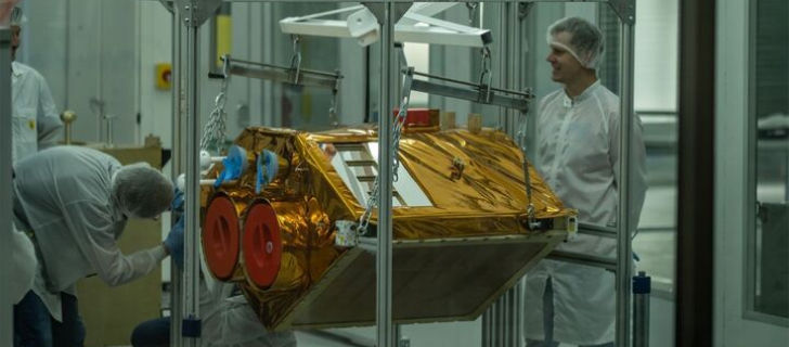
The satellite was built by Dragonfly Aerospace, a space imaging systems technology provider.
EOS SAT-1 will assist agribusinesses in monitoring crop growth and detecting heat, cold, water stress, weed spread, pest attacks, and other issues threatening crops. The companies will also be able to optimize their input use based on productivity and vegetation maps processed from data provided by the satellite, test the effectiveness of new crop protection products or fertilizers, avoid unnecessary field inspections and thus reduce fuel use, manage irrigation, estimate yields, and more.
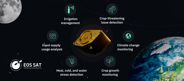
EOS SAT-1 can monitor up to 1,150,000 square kilometers daily using 11 agri-related bands. Even with only one such satellite in the sky, EOSDA customers unlock the potential to implement precision agriculture practices and thus reduce CO2 emissions, cut energy consumption, decrease water usage, and more.
I would like to congratulate the entire team of EOS Data Analytics on the launch of EOS SAT-1. This launch brings new game-changing possibilities of satellite technologies to the agricultural industry. EOSDA will now work with proprietary datasets to provide even deeper and more accurate insights for its customers and partners.
We’re excited to be the technology partner for EOS SAT-1. The demand for high-performance, compact, and lightweight satellites keeps growing each year, providing a great market for our imaging products. At the same time, it is great to have a customer with such a clear focus on addressing issues that are key to the sustainability of life on the planet. Having an agri-focused set of sensors, EOS SAT-1 will collect the data that can actually help decision-makers take care of the Earth and maintain its biodiversity while providing food security for its many people.
At the moment, most competing companies are forced to work with the data provided by third-party satellites, which makes them dependent on the quality of their sensors, the frequency of imaging, and other parameters they have no control over. Being oriented specifically at the needs of the agriculture industry, EOS SAT-1 will provide unprecedented amounts of data for EOSDA as often and detailed as the company’s clients need.
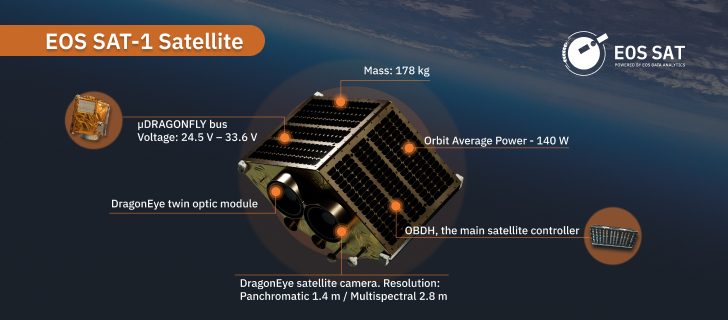
To address the issues of existing satellites, such as low sensor resolution, limited spectral capacities, and poor performance during cloudy weather, EOS SAT-1 satellite cameras will capture imagery using 11 agri-related bands: RGB, 2 NIR channels, 3 RedEdge channels, WaterVapor, Aerosol, and Pan.
About the author:
Rim Elijah holds a double degree in business administration and political science from Stockholm University. As a VP of Sales at EOSDA, she oversees all aspects of business model development and implementation and the growth of the company’s global coverage. She has successfully established a number of strategic partnerships with an emphasis on sustainable solutions in Africa and Asia.
Recent articles

EOSDA advances rice field mapping in Indonesia with SAR
EOSDA tested a radar-based approach to improve rice field detection in Indonesia. By integrating SAR and optical data, the team ensured stable monitoring even during peak monsoon months.
From the Moon mission to practical Earth solutions
Space technology allows us to look further than ever before, but its value is twofold: as the NASA Moon mission explores new frontiers, we use that same vantage point to solve Earth problems.

EOSDA to Monitor Wildfires in Portugal Using Satellite Data Under ESA’s InCubed Programme
The company signed a contract with ESA to create an innovative satellite-based solution for forest monitoring and wildfire prevention.