Sixty-five years after the launch of the first artificial satellite for Earth observation, satellite remote sensing has advanced dramatically. Ubiquitous internet connectivity, increased computing power, data storage capabilities, and processing speed influenced satellites’ capabilities to acquire, process, and transfer data. Every day satellites monitor millions of square kilometers of the planet’s surface and generate dozens of terabytes of data for research and commercial needs of customers from various industries: mining, forestry, meteorology, agriculture, etc.
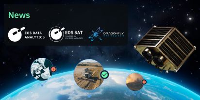
EOS Data Analytics, a global provider of AI-powered satellite imagery analytics, is about to enter the satellite manufacturing industry by launching an agriculture-focused constellation — EOS SAT.
EOS SAT Agricultural Satellite Constellation By EOS Data Analytics: What’s Special About It?
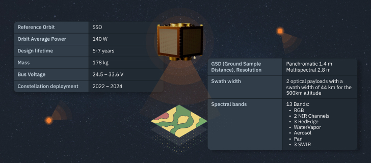
The constellation will consist of seven small satellites (178 kg) flying above the sun-illuminated section of the Earth 50% of the time. By following a low Earth sun-synchronous orbit with constant lighting conditions, satellites can make high-quality imagery.
Today’s technologies permit equipping even a lightweight satellite with all necessary hardware to meet the needs for high-resolution data generation. Coverage capabilities of small satellite constellations increase with the number of satellites. We calculated that seven satellites will be ideal for our goals.
The first satellite (EOS SAT-1) planned to be launched in 2023 has two DragonEye electro-optical sensors installed on a 100 kg-class Dragonfly satellite bus.
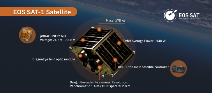
The other six satellites’ deployment is scheduled for 2023–2025; by 2025, EOS SAT will reach full capacity. The manufacturing team will update the satellites’ hardware in the following years. For instance, they will improve the speed of the X band ratio to increase the volume of data transferred to ground stations.
The constellation’s primary purpose conditions the choice of technical characteristics. EOS SAT is manufactured for imaging cultivated lands and forest areas, analyzing generated data for learning about plant development and soil condition, and correlating these insights with meteorological and crop/forest management data.
Let’s overview the constellation’s main characteristics and features.
Spectral bands. Satellite cameras have sensors that detect light energy within specific regions (ranges) of the electromagnetic spectrum, each corresponding to a spectral band. EOS SAT satellites will capture images of the planet’s surface using the following agri-related bands:
- RGB
- 2 NIR channels
- 3 RedEdge channels
- WaterVapor
- Aerosol
- Pan
- SWIR
EOS SAT-1 will have 11 spectral bands, excluding SWIR. The other six satellites will be equipped with 13. So, starting with EOS SAT-2, every machine will have two extra SWIR (Cirrus 1.360–1.390 and 1.565–1.655) bands.
Spectral bands are selected based on the properties of light passing through our atmosphere. These 13 bands are sensitive to electromagnetic wavelengths using which one gets minimum distortion and attenuation of light waves that are reflected from the Earth’s surface. Hence, users can get imagery that accurately depicts objects of interest.
Spectral bands allow for obtaining specific information about a studied feature, so every band has its use cases. For example, the NIR (near-infrared) band is used for detecting chlorophyll levels: the healthier the plant, the more chlorophyll it has and reflects more NIR wavelengths. Also, NIR is effective for monitoring plants and contrasting bodies of water against the surrounding features and can be applied for detecting soil moisture content.
Imagery captured using the SWIR (short-wave infrared) wavelength has strong contrast. Hence, it can be used to sort high-value agricultural produce from the lower grade and assess fruit and crop maturation.
Water is highly light-absorbent in this wavelength, so it looks almost black in images of objects illuminated using SWIR cameras. So, if one applies an appropriate filter or light source, they can define moisture content in bruised fruit, bulk grains, or well-irrigated crops. On the contrary, SWIR makes evaporation and extreme dryness seen on photographed objects, so it’s possible to predict water stress in crops, implement precision irrigation, and detect soil salinity caused by the lack of water, high evaporation rate, and poor drainage. To sum up, by using SWIR imaging, farmers can timely deal with spotted problems to avoid further crop damage and loss, estimate yields, check the quality of agricultural produce, and assess its maturation.
In general, satellites will provide panchromatic and multispectral imagery. A panchromatic image uses a single band that combines three bands visible to the human eye — Red, Green, and Blue. Such an image looks greyscale and doesn’t contain any wavelength-specific information. A multispectral image depicts the same area but comprises several layers acquired at a specific wavelength band.
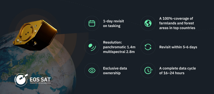
Revisit times. Satellites will take images of the same farmland and forest areas every five to six days. But the interval between imagery acquisition can be decreased to one day on customer demand (a field-level tasking). Custom tasking for larger territories (country-level) may take up to four days, depending on their location, a satellite’s orbit length above the surface of the area of interest, and area size. Anomaly detection tasks can be done within a day.
Coverage. EOS SAT-1 will monitor around 0.8–1 million square kilometers daily, while each of the six satellites will cover nearly 1.3–1.4 million square kilometers. Once in orbit, seven satellites will monitor 8.6–9.4 million square kilometers daily. We have an additional capacity to reach 12 million square kilometers by increasing a satellite’s average downlink rate.
It’s planned that by 2025 the seven-satellite constellation will cover 100% of countries with the largest areas of farmlands and forestlands, which amount to 98.5% of such lands worldwide.
It will also monitor 100% of farmlands in the top 20 countries with the biggest potential in the agricultural sector; in other words, in leading countries by agricultural and forestry areas. For the estimates, EOSDA specialists relied on open-source research and their classification of global agricultural lands based on analysis of MODIS data.
Data cycle. The data cycle — the sequence of stages of working with data — will be 16–24 hours, with the possibility of shortening the time up to three hours within a prioritized tasking. These stages include image generation by a satellite, acquisition of imagery data by four ground stages across the planet, data storage, preparation, and processing (using machine learning methods for analysis), and presenting insights to end-users.
A panchromatic image can be combined (fused) with a lower-resolution multispectral one to increase its spatial resolution and highlight surface features.
The ground sampling distance (GSD) resolution of panchromatic and multispectral images is 1.4 and 2.8 m, respectively.
Exclusive Satellite Data To Support Sustainable Crop Production
While competitors can also provide daily coverage similar to ours, having proprietary data sources brings advantages.
Other companies generally cooperate with satellite imagery providers, which do not always provide data captured using spectral ranges needed for vegetation indices. On the contrary, EOSDA manages the full data cycle in-house. We set requirements for imagery, its temporal resolution, and processing, so we’re sure to get high-quality data with the same parameters regularly. This also means that required imagery for an area of interest will get into a tasking list and will be processed specifically for indices a client specified.
Frequent revisits for continuous provision of up-to-date data suited for solving agro-related tasks will ensure even more accurate analytics results to support decision-making for end-users: food producers, input suppliers, insurers, or banks.
Achieving almost complete coverage of agricultural lands worldwide in 2025 will bring EOSDA closer to fulfilling its commitment: providing high-quality imagery and satellite monitoring analytics to support sustainable agriculture. After all, producing more healthy food while using fewer resources and minimizing environmental harm benefits agricultural businesses, consumers, and the planet.
About the author:
Natalia Ivanchuk holds a Master’s degree in Applied Mathematics from the National University of Water and Environmental Engineering. She is an author of 60+ scientific publications, monographs, and other scientific works.
Natalia's expertise and constant desire to learn and perfect her programming skills (C++, C#, JS, Python), has been most beneficial for EOS Data Analytics.

More news
EOSDA tracks construction progress in the UAE PAD areas
Managing rapid industrial expansion in the UAE requires accurate data. See how our satellite-based solution helped a client verify construction milestones and reduce inspection costs.

Validating satellite tech for flood analysis and damage mapping in Coimbra
Can satellites improve disaster response? We explored this in the Coimbra district, showing how integrated satellite intelligence can assess flood impacts and fill critical data gaps during a crisis.

EOSDA advances rice field mapping in Indonesia with SAR
EOSDA tested a radar-based approach to improve rice field detection in Indonesia. By integrating SAR and optical data, the team ensured stable monitoring even during peak monsoon months.