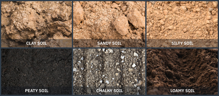
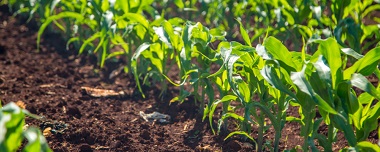
When it comes to crop production, considering the types of soil is essential. Six main soil types are typically distinguished in agriculture. Each of them has specific physical and chemical properties. While some types of soil are more productive and accommodating, utilizing amendments suitable for each type can still benefit growers.
The state of a field constantly changes due to various causes and must be regularly examined. Satellite technologies can be advantageous for pinpointing areas requiring immediate rehabilitation and tracking changes over time.
Different Types Of Soil By Texture
The ground consists of all the chemical elements that occur naturally in their solid, liquid, and gaseous states. Additionally, there are countless combinations of qualities that determine the physical and chemical conditions of the ground. No wonder scientists have designed diverse approaches for grouping soils by various features and applications.
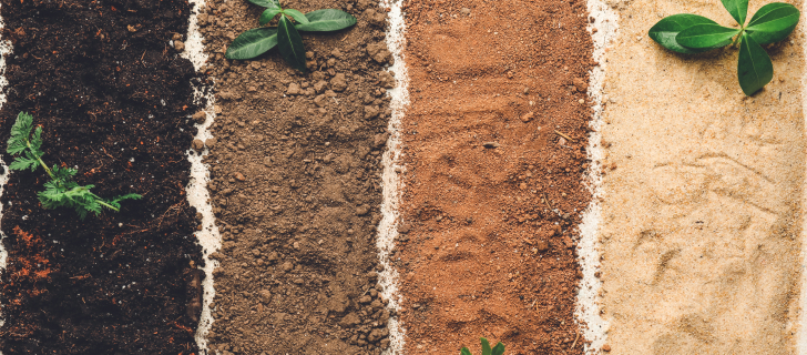
The textural classification, which divides soil into three primary groups based on the size of its particles, is one of the most often used systems. By size, constituents create three main soil types: small, which stands for clay; medium — for silt; and large — for sand.
| Component | Clay | Silt | Sand |
|---|---|---|---|
| Size of particles, mm | < 0.002 | 0.002 – 0.05 | 0.05 – 2 |
| Tilling | Difficults | Easy, but needs extra effort while drying out | Easy |
| Nutrient content | Rich | Sufficient | Poor |
| Drying out | Slow, along with cracking | Not too fast, along with cracking | Fast |
| Warming up in spring | Slow | Fast | Fast |
| Water retention | Too long-lasting | Sufficient, while draining well | Poor |
| Intake rate*, inch/hour | 0.1 | 0.3 | 0.6 |
| Field capacity**, % | 36 | 26 | 10 |
**Field capacity is the soil moisture percentage when extra water is gone.
The smaller the particles in the ground are, the more erosive the soil is. Thus, sandy ground (except for the fine sand) has a low erosive potential , while clayey and loamy — moderate, and silty — highest.
Most grounds are not pure but are compounds of clay, sand, and silt. The texture, in this case, is defined by the relative proportions of each component. For instance, clay with a high silt content is called silty clay. The U.S. Department of Agriculture (USDA) has created textural categorization and textural triangle — types of soil chart for a more accurate texture measurement. Knowing the texture is essential as it indicates permeability, ease of tilling, plant growth potential, and more.
Soil Types Grouping By Composition
Grouping soil types by their composition is well-suited for agricultural purposes. This classification enables you to consider the most appropriate crops, cultivating practices, irrigation, amendment, and fertigation techniques.
There are six most common types of soil for agriculture: sand, clay, silt, chalk, peat, and loam.
Sandy Soil
The main advantage of the sandy type is that it is suitable for early planting because it is the first to warm up after winter. It is not too prone to erosion due to the large size of the particles. Sandy ground has a loose structure which makes it effortless to till. For the same reason, water quickly seeps into the lower layers of the ground, washing away nutrients with it. Additionally, the sandy type is often acidic, meaning it has a low pH level. Plants growing in sandy soils may thus be deficient in the nutrients and moisture necessary for their growth.
Every group has distinct features suitable for some plants, helping them flourish, while making others perform poorly. You can choose the most suitable plants, considerably cutting effort while ramping up crop productivity.
Types of crops grown in the sandy ground:
- commercially cultivated plants that do well in sand include collard greens, tomatoes, melons, squash, strawberries, sugarbeet, lettuce, and peppers;
- plants that do well in sand with good irrigation: maize, millet, and barley;
- root vegetables: potatoes, parsnips, and carrots;
- shrubs and bulbs: tulips, tree mallow, sun roses, and hibiscus;
- herbs native to Mediterranean climates: oregano, rosemary, and lavender.
Types of crops difficult to grow in the sandy ground:
- brassicas like broccoli and cabbage;
- peas and beans.
Clay Soil
Clay’s heavy and compact structure holds moisture well and is ideal for moisture-loving plants. Many crops will thrive in this type of soil due to the high nutrient content. Meanwhile, clay is frequently alkaline which stops plants from getting all the nutrients they require to flourish and produce a high yield.
Clay warms up slowly making it unsuitable for sowing plants in early spring. A significant disadvantage of this soil type is that it is rather challenging to work with: it often becomes sticky and waterlogged in winter and turns into solid blocks when it dries up in summer.
Types of crops grown in clay soil:
- vegetables: broccoli, cauliflower, kale, peas, potatoes, cabbage, and Brussels sprouts;
- leafy crops;
- fruit trees;
- perennials;
- ornamental plants;
- shrubs, including aster, Helen’s flower, and flowering quince.
Types of crops difficult to grow in clay soil:
- root vegetables like parsnips and carrots;
- soft berries;
- desert and other plants that need fast draining.
Silty Soil
Silty ground particles have physical properties somewhere between those of sand and clay. Because of its fine texture, silt holds more water than sand. Silty types of soil are fertile and contain a sufficient number of nutrients. Most plants will thrive when the drainage system is channelized correctly for silt.
When there is enough moisture, this type of ground is soft and smooth, so that it is easy to cultivate. The disadvantage of silt is that it compacts easily making it difficult to till when it dries out.
Types of crops grown in silty soil:
- most vegetables;
- climbing plants;
- perennials;
- grasses;
- shrubs;
- trees, including willow, birch, and dogwood.
Types of crops difficult to grow in silty soil:
- root vegetables, including parsnips and carrots;
- desert and other plants that need fast draining.
Chalky Soil
The chalky ground is usually light and easy to work with in any season. At the same time, it contains stony inclusions. The good news is that chalky types of soil drain well, so you won’t have to worry about it. However, rapid drainage, especially in hot weather, can cause the ground to dry out.
The problem with the chalky field is that it is too alkaline and deficient in certain minerals such as iron and manganese. Plants grown in the chalky ground are often stunted and have yellowish leaves. Thus, you must use the proper kind of fertilizer to balance the pH to grow healthy crops.
Types of crops grown in the chalky ground:
- vegetables: spinach, beets, cabbage, and sweet corn;
- flowers like lilac, weigela, madonna lilies, mock oranges, Californian poppies, and wallflowers;
- climbing plants, including akebia, clematis, grape vines, ivy, jasmine, lonicera, and Virginia creeper;
- trees and bushes.
Types of crops difficult to grow in the chalky ground:
- berries such as blueberries and raspberries;
- tomatoes.
Peat Soil
The peat structure is spongy and resistant to compaction, so it heats up quickly and retains water well. It has good aeration and allows the roots of the plants to breathe. The absence of pathogens distinguishes peat soil types. Because it contains few harmful bacteria, the peaty ground is an excellent choice for seed starting. Its acidic condition limits plant nutrient availability, so you’ll need to supplement crop production with fertilizer.
The major drawback of peaty ground is that it is a non-renewable resource. A decrease in peaty ground quantity can contribute to climate change by releasing greenhouse gases into the atmosphere.
Types of crops grown in the peaty ground:
- brassicas;
- legumes;
- salad greens;
- root crops;
- blueberries and other acid-loving berries;
- shrubs such as witch hazel, rhododendrons, lantern trees, and heather.
Types of crops difficult to grow in the peaty ground:
- peppers;
- tomatoes.
Loamy Soil
Loam comprises three different materials: silt, clay, and sand. The variety in particle sizes creates openings in the ground that allow air, water, and roots to pass through freely. Loam doesn’t dry too fast; it is soft and almost effortless to till.
Loam type of soil contains all of the nutrients required for active plant growth. It also has high calcium and pH levels, as well as hummus. The minerals soluble in water easily nourish plants’ roots, resulting in high yields.
Types of crops grown in loamy soil:
- most vegetables;
- root crops;
- wheat;
- cotton;
- sugar cane;
- most fruits;
- berries;
- climbing plants;
- flowers, including roses, irises, gladiolus, and lilies.
Types of crops difficult to grow in loamy soil:
- tomatoes (seedling stage onward);
- green beans;
- brassicas, including late-growing cabbage;
- cacti and other desert plants.
Soil Types Identification Principles And Techniques
There are two primary approaches to identifying the soil type: do-it-yourself tests and professional laboratory examinations. Both options have distinct limitations and application scope, which we will go through in more detail.
Do-It-Yourself Tests
Self-testing is an easy way to get a quick grasp on your major soil types. The good thing is that it is usually either free or very inexpensive. Nevertheless, you can’t rely on absolute precision here.
The type of soil is typically determined by touch, using the following steps:
- Collect multiple samples from different sites in the field and mix them.
- Take out any gravel and lumps from the sample and use the remaining material for the most accurate DIY testing possible.
- Knead and roll a small piece of wet ground in your hand.
- Determine different types of soil based on the following characteristics: stickiness, oiliness, and easy spreading, which indicate high clay content; silky texture, pointing to silt; grit, prickly, and difficult spreading, the tell-tale signs of sand.
Professional Laboratory Examinations
A laboratory study typically lasts several weeks and includes a broad range of soil quality indicators such as pH, organic matter, and nutrient cycling. Professional tests provide a high level of indicator reliability. For conducting lab tests, there are two options:
- Laboratories perform the entire research process, but such tests are pretty expensive.
- You take samples yourself and deliver them to the laboratory for further testing. In this case, it is your responsibility to decide where and how many subsamples to take.
How To Improve Different Soil Types
You can enhance ground quality and plant growth in different soil types using amendment techniques suitable for the soil type. Improvement practices include adjusting the soil pH level, drainage, moisture retention, and adding specific organic amendments. The advantage of amendments is that they incorporate free or inexpensive supplements, such as green manure, compost, leaves, and grass clippings, improving any soil type for plants.
Amendments indirectly influence plant growth by changing the ground’s physical structure and improving its health, while fertilizers directly affect plants, boosting the nutrients in the ground.
| Type of soil | Amendment |
|---|---|
| Sand | Plenty of organic mulches, peat moss, compost, zeolite, or bentonite clay. |
| Clay | Compost and other organic matter. |
| Silt | Drainage aid particles, such as sand or compost. |
| Loam | Any organic amendments at least once a year. |
| Chalk | Mulching around plant crowns and plenty of organic matter, such as humus, manure, composted pine needles, or leaf mold. |
| Peat | Sand, compost, mulch, and other drain-improving materials. |
Soil Type Productivity Monitoring With Satellite Technologies
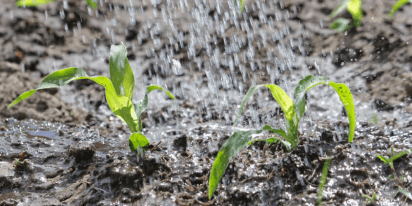
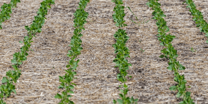
All types of soil are prone to exhaustion over time, especially if there are no efforts to preserve their fertility. Meanwhile, improper tillage might also disrupt the structure of the ground. With all this said, you must routinely evaluate field performance to make an informed choice of methods for boosting fertility.
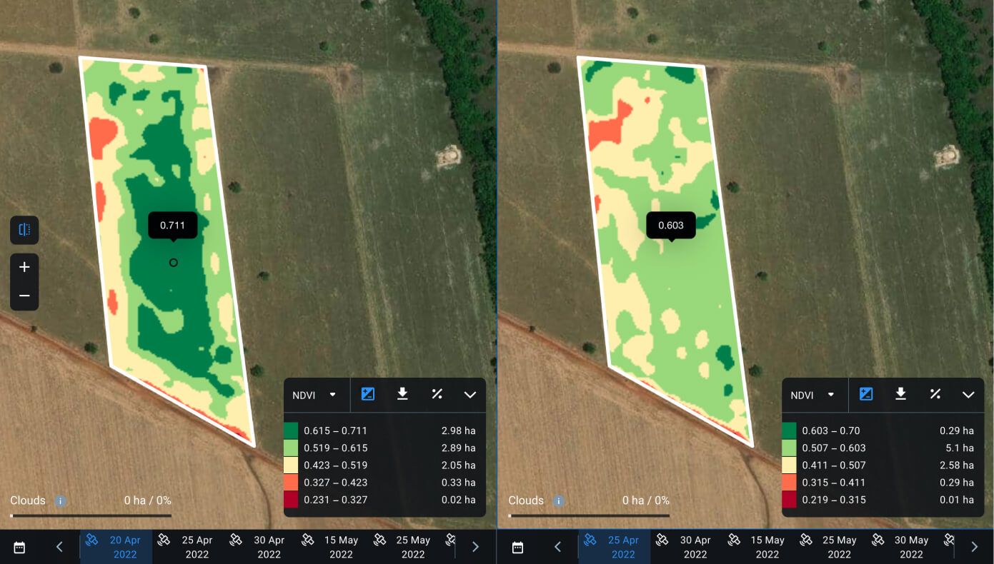
Daily Monitoring With Vegetation Indices
While satellite technologies cannot evaluate soil quality directly, they do provide information on crops’ current state. EOSDA Crop Monitoring makes it possible to monitor how well the crops are doing so that you can assess the soil types’ condition routinely.
In the short term, monitoring the health of crops using vegetation indices will help to evaluate the outcomes of fertilizing, watering, improving drainage, altering the pH level, and other activities. Whenever the crops show signs of wilting, stunted growth, or various crop diseases, you can use the vegetation indices to pinpoint the most problematic areas in the field for a more precise analysis. Based on this analysis, you can make adjustments to grow healthier crops and get more yields.
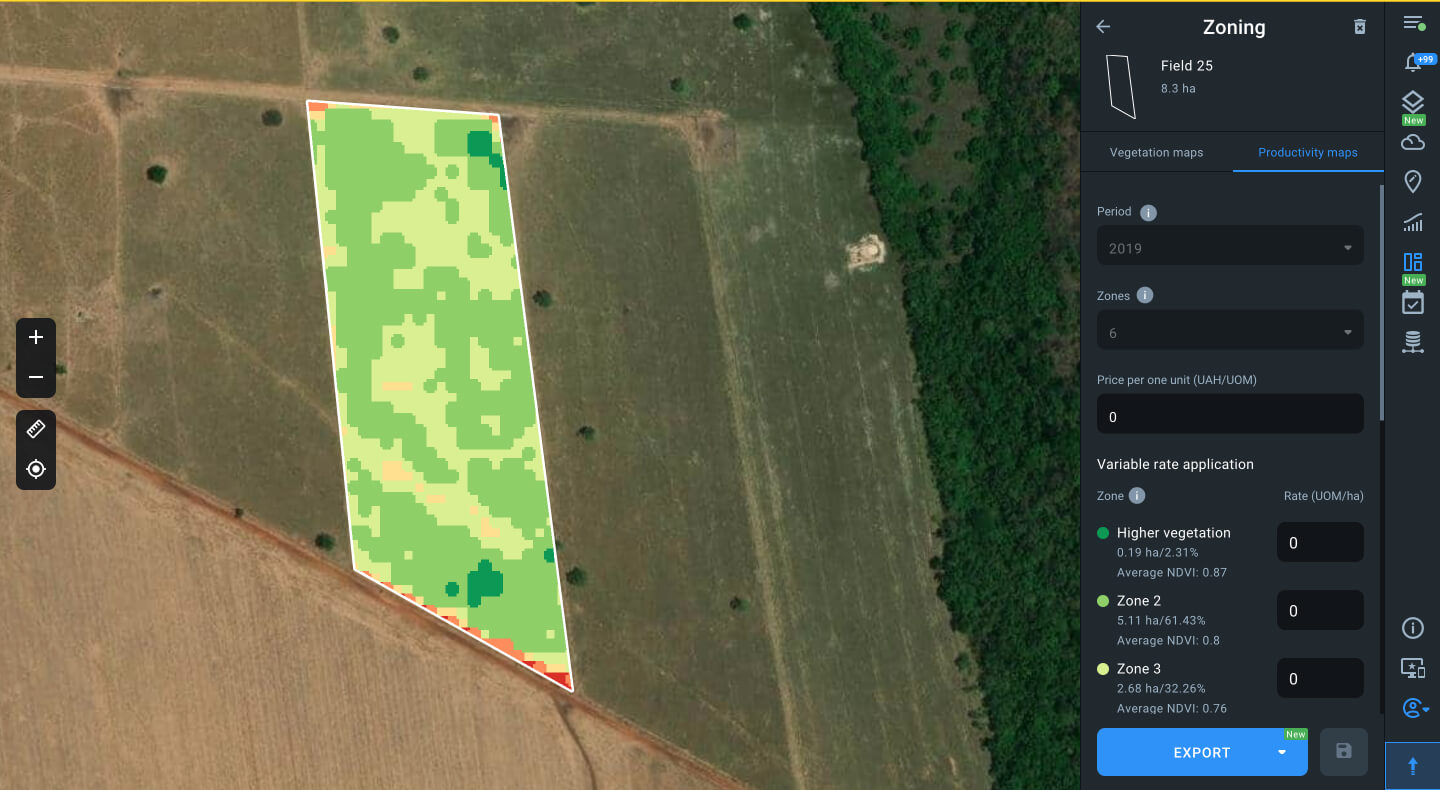
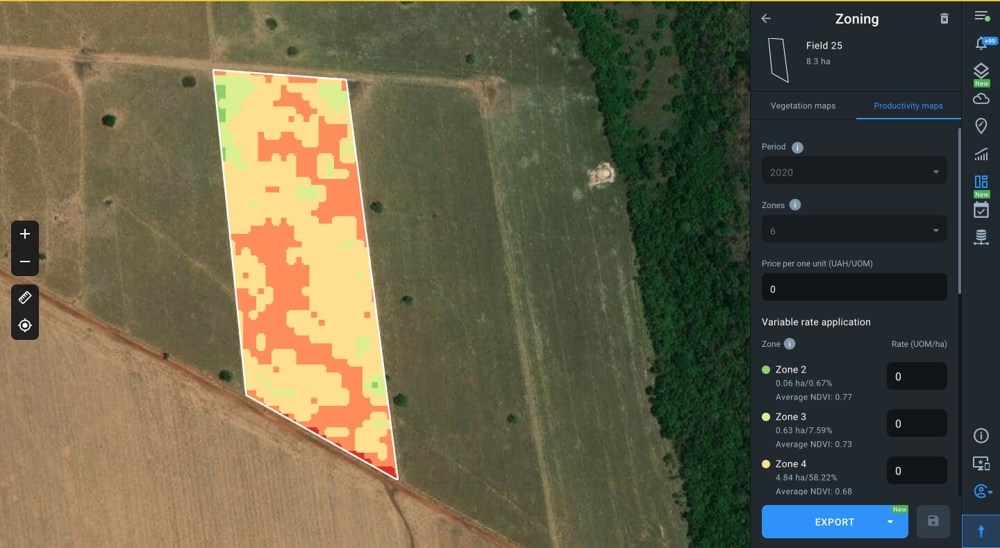
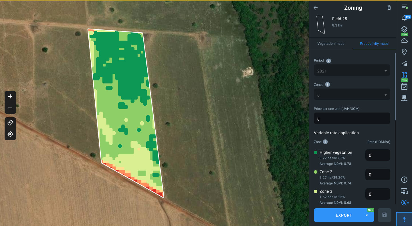
Historical Soil Types Evaluation Using Productivity Maps
Even with regular monitoring, it’s critical to look at longer time frames because the soil’s qualitative properties may vary dramatically with time. The basic guidance is to analyze at least several seasons and track productivity changes in each field.
EOSDA Crop Monitoring enables historical field evaluation using past periods, for instance, particular seasons or a number of them, and comparing these periods with each other. Moreover, theplatform offers Productivity Maps for adding precision to soil type analysis and ground sampling. You can effectively plan cultivation and improvements by understanding how plants grow in every corner of your field.
The Best Soil Types For Farming
Any farmer will tell you that the best type of soil is the one that yields a plentiful harvest with the least amount of tillage and fertilizer applied. But do the best types of soil exist? Both scientists and growers agree that loam is the easiest to work with yet the most fertile. Because of its precisely balanced composition of 40% silt, 40% sand, and 20% clay, loamy soil maximizes positive effects while utilizing each component’s most outstanding qualities.
However, there is no need to feel down about any type of soil. Knowing the soil types you are working with allows you to make the best possible amendments and choose the plants that produce the most fruit. Whether it is loam, sand, or any other type, it is still required to cultivate and keep an eye out for any changes.
Make the most of your fields with the EOSDA Crop Monitoring tool. Every step of the way, satellite technology will be there to help. Contact our sales team at sales@eosda.com for more details on features suited for your business and schedule a brief demo.
About the author:
Vasyl Cherlinka is a Doctor of Biosciences specializing in pedology (soil science), with 30 years of experience in the field. He attended the engineering college in Ukraine and received his degree in agrochemistry, agronomy and soil science in the Chernivtsi National University. Since 2018, Dr. Cherlinka has been advising EOSDA on problems in soil science, agronomy, and agrochemistry.
Detect crop risks earlier with AI-powered field alerts.

More news
Soil Moisture: How To Measure & Monitor Its Level
Soil moisture content has a profound effect on the development of crops. Different soil moisture measuring instruments help farmers to maintain its optimal balance. One of the most effective is satellite monitoring.
No-Till Farming: Way To More Sustainable Agriculture
No-till farming highlights: core methods and practices, pros and cons, and how EOSDA Crop Monitoring contributions to facilitation and implementation of the concept.
Slope Erosion: Underlying Factors And Control Methods
Slope erosion is a particularly difficult problem for farmers to deal with in hilly areas. Fortunately, there are now lots of options for preserving fertile hillside soil.