The modern agricultural business is evolving in a variety of directions at the same time. However, its primary focus is utilizing agricultural technologies to boost crop yields through better planning and smarter management. By promoting more efficient and sustainable farming methods, advanced technology in agriculture helps farmers prosper in today’s agribusiness. Time-tested practices like crop rotation and new agricultural technologies, such as monitoring field productivity with machinery and satellite images or special farming software, all contribute to the viability of agriculture.
What Is Agriculture Technology?
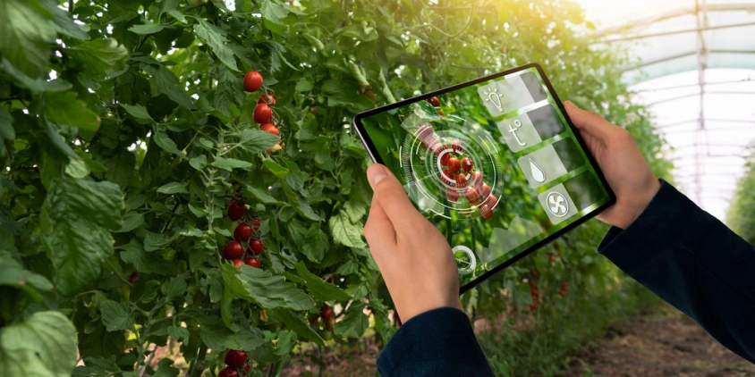
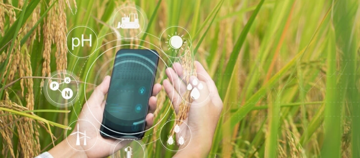
Agricultural technology, also known as “agritech,” encompasses a broad range of disciplines and devices that improve agricultural output. That includes vehicles, robotics, computers, satellites, drones, mobile devices, and software. The use of big data analytics and artificial intelligence (AI) technology in agriculture is also an example of how the farming sector is embracing technological advancement.
Changes in farming and field management during the past few decades have been revolutionary. The employment of modern, state-of-the-art technology in agriculture can be credited with much of the recent success in crop management and increased harvests.
Importance Of Technology In Agriculture
Agricultural technology aims to make work in the field more efficient and convenient. Each year, there are various new agricultural innovations and, occasionally, ground-breaking technologies. As agribusiness continues to modernize and grow, it is becoming increasingly crucial for agricultural consultants, food producers, and technology managers to be knowledgeable and up-to-date with the latest technological standards.
Water, fertilizer, pesticides, and other inputs are no longer applied “by eye” or uniformly across the field by large agricultural producers. The use of advanced agriculture technologies allows for the precise application of only what is required in each location, as well as the careful tailoring of treatment for each plant.
Benefits Of Technology In Agriculture
The implementation of smart agricultural technology is advantageous for all players in the agri-food chain. With its use in optimizing and automating agricultural operations and field activities, growers and landowners can now save significant amounts of time and effort. These are just a few examples of how farming has benefited from advances in agriculture technology:
- using less water, fertilizer, pesticides, and other inputs allows agricultural producers to cut costs and keep more of their profits;
- by preventing or drastically reducing the amount of chemical runoff into waterways, businesses lessen agriculture’s impact on the environment and take steps toward greater sustainability;
- increasing crop yields while decreasing labor inputs;
- making it easier for farmers, agronomists, or other agricultural workers to communicate and coordinate activities using mobile devices, apps, or web-based resources;
- lowering barriers to accessing agricultural insurance and financial services as well as market and technological data;
- mitigation of the damage that could be caused by pests, natural calamities, and bad weather in agriculture with the help of affordable, always-on agricultural monitoring systems;
- increase in farm income through improved product quality and increased quality controls;
- timely recognizing nutrient deficiency in plants and notifying agricultural producers of the type and amount of fertilizer and other amendments needed;
- ability to foresee potential problems on the farm through the visualization of production patterns and trends gleaned from an analysis of current and historical agricultural data. By estimating their overall crop yield, agricultural producers can precisely budget for the next growing season and better prepare for emergencies.
Evolution Of Agriculture Technology
Technological progress in agriculture is intrinsically linked to the rise of urban centers and commercial exchange. New technological developments have always been prevalent in this field.
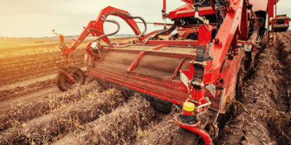
Nonetheless, the technological model of agricultural production remained largely subsistence-based and characterized by poor productivity until the early 20th century. This era, known as “Agriculture 1.0,” is marked by the invention of the plow and the widespread use of animal drafts. Agriculture 2.0 started towards the tail end of the 19th century with the introduction of mechanical machinery such as tractors. And later on, agricultural technology underwent a number of active development cycles as the pace of technological progress increased tremendously.
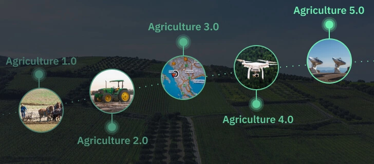
Agriculture 3.0, Or Precision Farming
Precision or smart farming, also called Agriculture 3.0, evolved out of the need to track and more efficiently manage all inputs into crop production. The pursuit of precision agriculture and its associated agricultural technology has led to the development of new farming methods and tools.
The Global Positioning Satellite System (GPS) was the breakthrough technology that made this age of farming possible. GPS helps find deviations within a given agricultural production space, allowing for more effective use of available resources. This was the main reason why the idea of sustainable agriculture and a number of automation options came about.
Agriculture 4.0, Or Connected Farming
The leap from smart farming to connected farming is a good example of how fast production technology used in agriculture moved forward at the turn of the century. Technology like autonomous machines, sensor-equipped robots, augmented reality, the Internet of Things (IoT), drones, and satellites is all part of the new agricultural environment, named Agriculture 4.0 .
Decision-making in the agricultural sector is now based on data that is stored in the cloud and accessible via digital tools. With the help of this analyzed data, farmers and other major players in the agricultural industry can make better decisions.
Agriculture 4.0 is being born in an era of ubiquitous automation and digital connectivity. All developments in agricultural technology are becoming more integrated and networked, with the goal of optimizing all stages of the production process and enhancing monitoring, management, and control of the business.

Agriculture 5.0, Or Digital Farming
Agriculture technology 5.0, or simply put, “digital agriculture,” refers to the next generation of farming methods and tools for maximizing crop yields and other agricultural outcomes. One such technology is 5G, which is currently undergoing rapid development and will improve the reach and accessibility of the latest agritech achievements around the world.
Compared to prior farming methods, digital agriculture technology excels in the following aspects:
- data collection efficiency: how much data can be collected in a given amount of time or space;
- data accuracy: how close a measurement is to the truth;
- timeliness: how quickly the data can be processed into practical information and reported to end users.
When it comes to weather, pests, and diseases, agricultural producers have little to no control. Yet, with the advent of digital technologies in agriculture, they may lessen the negative influence of these elements. Meanwhile, digital agricultural technologies give farmers the opportunity to greatly increase the efficiency of decision-making and the return on factors that they directly control. Some examples are:
- what types of crops to grow;
- how to rotate crops for the best results;
- when and how much water to use for precision irrigation;
- when, how much, and what kind of nutrients and plant protection products to apply;
- what kind of tillage works best with a given type of soil.
Agricultural experts agree that the most valuable tools and technologies of digital agriculture regarding competitive advantages are cutting-edge farm management software, space-based solutions (especially those that provide high-resolution satellite images), proximal sensors, connectivity instruments, and data-driven algorithms for threat prediction.
Advancements And Innovations In Agriculture Technology
Agricultural technology has come a long way beyond the basics of planting, maintaining, and harvesting crops. From more resistant seeds to improved agricultural production planning and processing, many crucial improvements have been made in recent years. Improvements in agriculture technology can even enhance field-to-table distribution and logistics.
Rapid progress is also being made in the realm of agricultural software and technology, which facilitate both in-field labor and the management of different components of the food supply chain. Previously, monitoring the fields used to require going there in person, but now this may be done from afar. As a novel method for field observation, agricultural satellite technology is ideal for this purpose.
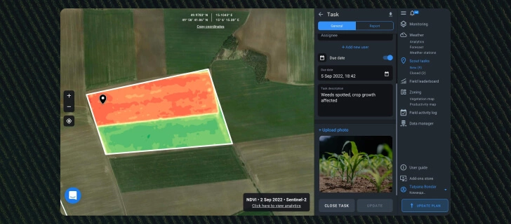
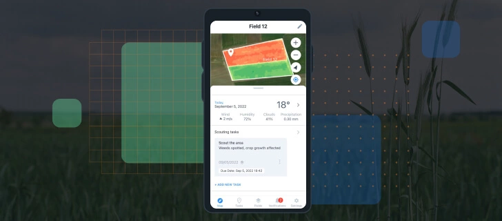
From assessing meteorological and historical field data to planning agricultural activities, EOSDA Crop Monitoring incorporates the relevant data at each stage of the decision-making process. This precision agricultural platform helps even when you need a human presence in the field. It can be used to assign in-field scouts to check out a questionable area and report back with what they find. Photos can be instantly attached to the task report from the smartphone.
Negative Impacts Of Agricultural Technology: Are There Any?
While it’s true that modern farming has reaped many benefits from technological developments in terms of higher efficiency, lower costs, and larger yields, there is another side to the coin, which is specifically related to large-scale extensive agriculture. The most significant are its harmful effects on nature. The primary agricultural technology issues having a negative impact on the ecosystem are:
- soil and water pollution from the extensive pesticide use;
- loss of biodiversity due to the elimination of indigenous species in favor of agricultural crops;
- release of greenhouse gases, which result from clearing forests to make way for agricultural land and the further overuse of machinery.
Not all the disadvantages of technology in agriculture are tied to the environmental impact. Some concerns are associated with the various aspects of agricultural technology adoption by growers and their staff, namely:
- farmers lacking the education and hands-on experience needed can’t operate machinery and software effectively, rendering them unable to take advantage of today’s advanced agricultural technology;
- the machinery upkeep cost is really high;
- the use of chemical fertilizers and pesticides can harm the health of farmers and other agricultural employees who work on the land.
As agricultural technologies allow us to meet the food needs of the world’s expanding population, it’s clear that we can’t turn our backs on them. But we can make their negative effects less severe by using and improving precision agricultural techniques that go hand in hand with eco-friendly practices. Because these technologies have the potential to reduce or even eliminate the adverse impacts of conventional farming methods, they help solve a wide range of environmental problems. In this way, industrial agricultural producers may get two birds with one stone: increase their competitive edge and benefit global long-term welfare at the same time.
What Types Of Precision Agricultural Technology Are Now In Use?
Maximizing yields and keeping up with the times both require farmers to be well-versed in the latest technological advancements and their applications in the agricultural sector.
GPS Technology In Agriculture
By using GPS data, precision agricultural technologies improve productivity while decreasing wasteful spending on inputs like seeds, fertilizer, pesticides, and fuel. In addition to providing location-based agricultural information, GPS can be used to facilitate communication between vehicles and streamline record-keeping when combined with farm management software . Among the many uses this technology enables in the agricultural sector are the following:
- monitoring and managing field operations;
- collecting and analyzing data from the fields;
- accurate soil sampling;
- yield monitoring and mapping;
- navigating and controlling of agricultural machinery;
- the ability to operate in low-visibility field conditions like heavy rain or fog.
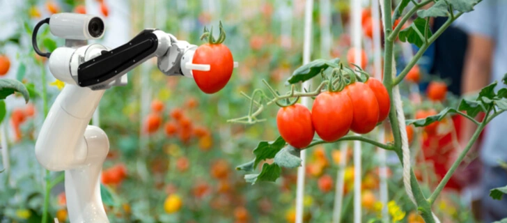
Robotic Technology In Agriculture
Robotic farm labor technology appears to be a viable choice for precision agricultural needs because it can do monotonous tasks without sacrificing accuracy. The autonomous performance of such robots would allow for continuous field management and improved agricultural productivity and efficiency as a result of the robot’s ability to gather information about its environment on its own . Autonomous devices operated remotely via telemetry are currently the most well-known and successful agricultural robotic technology.
Data Collection And Storage
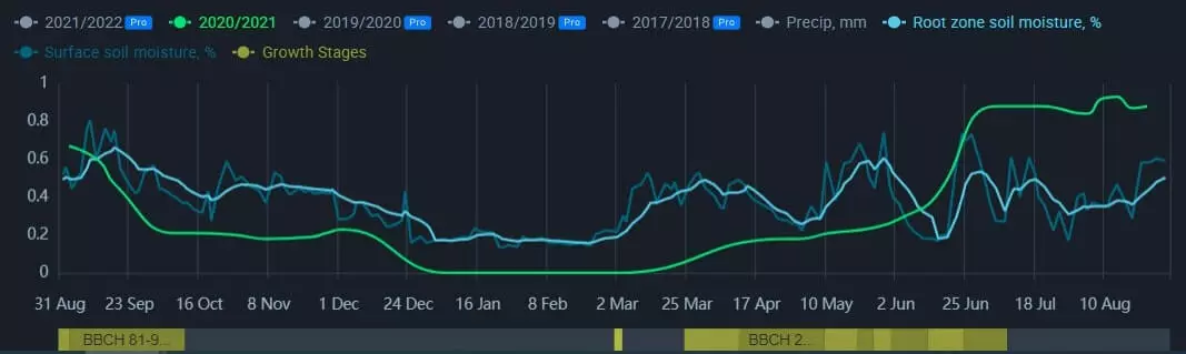
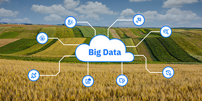
The incorporation of big data into agriculture technology has enhanced the flow of information, facilitated more fast and precise analysis, and ultimately resulted in improved decision-making and strategic planning. Analyzing historical agricultural data, we may foresee potential outcomes, evaluate risks, and choose the best course of action to take. Thanks to improvements in agricultural technology, more and more information about farms can be collected and stored. Soil pH, relative humidity, nutrient levels, soil moisture, and past weather data are just some of the ag-tech indices that can be derived from field data with the use of agricultural technology.
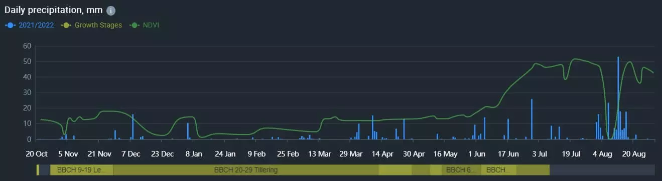
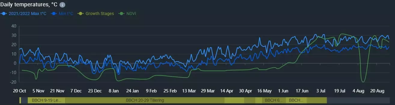
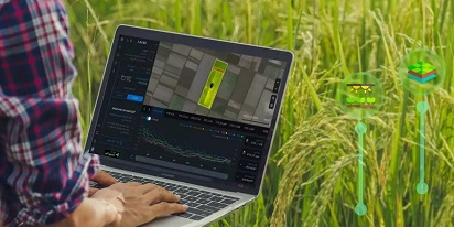
An abundance of information about root and surface soil moisture values, vegetation productivity, crop types, field height, weather conditions, such as past precipitation and temperature readings, agricultural activities (irrigation, sowing, harvesting), and much more is available through EOSDA Crop Monitoring. You can analyze the field’s volume and prior harvests, as well as make future harvest predictions, with the help of this agricultural data, which is presented on the platform in an accessible and simple format. In addition, this information has practical use in cooperative management, crop planning, and the identification of agricultural risks.
Smart Agriculture Sensors
Weather conditions, plant moisture, soil temperature and fertility, pest infestations, and weed locations can all be determined with the help of agriculture sensor technology. The use of this data assists growers, agri-consultants, insurers, and others involved in the agricultural sector in making more informed decisions, leading to more output from farms at lower costs.
Geographic Information Systems (GIS)
Geographical information systems (GIS) are essential for the storage, analysis, and visualization of spatial data for precision agriculture needs. One of the most important ways that GIS-based agriculture technology is used in farming is to gather information about a region’s crops, soil, climate, and topography by using satellites and drones. Furthermore, GIS in agriculture enables the use of GPS apps in conjunction with smart tools to optimize the spreading of fertilizer and pesticides.
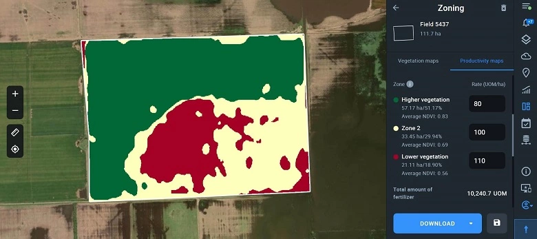
With the help of EOSDA Crop Monitoring’s GIS capabilities, you may generate field productivity maps utilizing the basic NDVI index over a few years. By using these yield mapping, it’s easy to pinpoint the most productive parts of your field, as well as low-yielding places that would benefit from additional fertilizer or other methods to boost field productivity. Applying the correct quantity of fertilizer to the soil might be a challenge, but yield mapping can help; farmers will not only save money on fertilizer but also ensure that they don’t pollute the soil and groundwater with the excess chemicals.
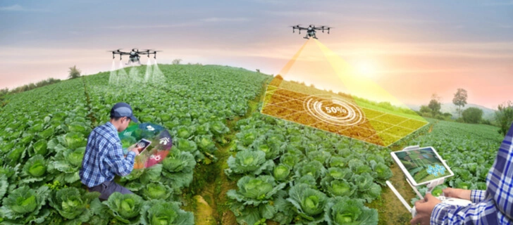
Agricultural Drone Technology
Drones, also known as unmanned aerial vehicles (UAVs), are becoming more and more common in the agricultural industry. Drones may scan a field from above and report on problems like pests, infections, and a lack of essential nutrients. This agricultural data gives farmers command over the state of their fields.
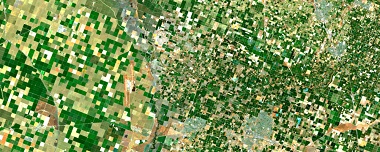
Satellite Remote Sensing Technology In Agriculture
The use of satellites has revolutionized field monitoring by greatly increasing both the sheer volume of agricultural data and the frequency with which it is collected. Satellite sensors monitor, measure, and record the electromagnetic radiation reflected or emitted by Earth and its environs for further analysis and data extraction. With agriculture satellite technology, such as current and historical satellite images, you can track crop growth throughout the season even in vast, inaccessible areas. This information is beneficial for various purposes, including assessing the effectiveness of agricultural practices.
In order to help agricultural producers and landowners make educated decisions, our one-stop agriculture platform processes satellite imaging data and makes it readily available along with vegetation indices and other essential field indications.
Mobile Technology In Agriculture
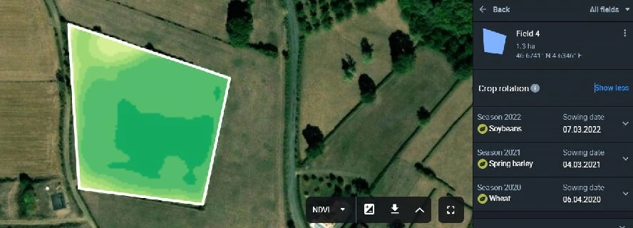
Agriculture-related mobile applications are currently expanding their market share and feature sets. By marking a field on a map and monitoring its NDVI vegetation index over time, the EOSDA Crop Monitoring mobile app allows you to keep tabs on a field’s vegetation from anywhere without having to pull out a bulky laptop. You can track the weather in the field, plan and manage scouting tasks, and get updates on your current situation all from the convenience of your mobile device. One of the many benefits of mobile technology in agriculture is that the application can function even when not connected to the internet.
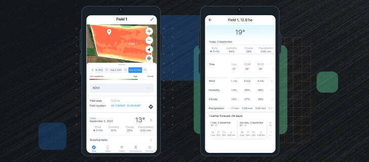
Temperature and precipitation information and vegetation tracking in the EOSDA Crop Monitoring application.
How Does Technology Impact Agriculture?
As a result of the information age, there are more ways to use technology in farming than ever before. Agricultural businesses rely on technology to improve field management, which is only one of the many ways that innovations have changed farming.
The use of inputs like fertilizer and pesticides can be reduced with the help of advanced agricultural software. One more plus is that agricultural technology helps cut down on harmful pollutants like carbon dioxide. This became possible by streamlining the agricultural production process and eliminating unnecessary steps.
With gene editing technology in agriculture, producers in different parts of the world can create seeds better suited to the specific conditions of their climate and native soil. Climate smart agriculture helps to solve many challenges in food production offering specific strategies for growing crops. New crops can be cultivated with the help of fertilizers precisely applied to the soil. Also, the mechanization of processes improves agribusiness’s productivity and efficiency across the board, including planting, harvesting, and distributing.
These days, when even drones are employed to keep an eye on agricultural fields, biotechnologies, nanotechnologies, and information and communication technologies (ICT) allow for the possibility of increasing crop yields in the most sustainable way possible.
Sustainable Prospects For Agriculture Technology
Accelerating technological advancements in farming are having a profound impact on the industry. Agricultural satellite technology is rising to the forefront to better manage inputs, streamline operations, and increase farm productivity. Higher yields and lower maintenance costs translate into greater agricultural earnings. Thus, leveraging satellites in the agricultural sector is a big step toward a more productive and sustainable farming technology that can keep up with the growing need for food around the world.
About the author:
Kateryna Sergieieva has a Ph.D. in information technologies and 15 years of experience in remote sensing. She is a Senior Scientist at EOSDA responsible for developing technologies for satellite monitoring and surface feature change detection. Kateryna is an author of over 60 scientific publications.

Detect crop risks earlier with AI-powered field alerts.

More news
Big Data In Agriculture Backed By Satellites & Sensors
The days when big data in agriculture was only for tech-savvy large farms are over. Today, easy-to-use platforms make it accessible to any farmer ready to work more efficiently.
Top Ready-Made Agriculture Tools & Softwares for 2025
Agriculture softwares are silent partners in the field, working tirelessly behind the scenes to support farmers with insights and precision to cultivate sustainable agricultural ecosystems.
GIS In Agriculture: Best Practices For AgriTech Leaders
It's hard to overstate the role of GIS solutions for agriculture, particularly for global industry leaders. If you strive for productive and sustainable farming, look at GIS systems that can track a variety of factors over vast areas worldwide.