Case studies by EOS Data Analytics
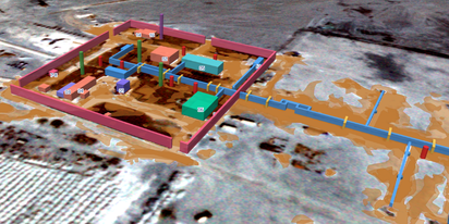
EOSDA tracks construction progress in the UAE PAD areas
Managing rapid industrial expansion in the UAE requires accurate data. See how our satellite-based solution helped a client verify construction milestones and reduce inspection costs.

Validating satellite tech for flood analysis and damage mapping in Coimbra
Can satellites improve disaster response? We explored this in the Coimbra district, showing how integrated satellite intelligence can assess flood impacts and fill critical data gaps during a crisis.

EOSDA advances rice field mapping in Indonesia with SAR
EOSDA tested a radar-based approach to improve rice field detection in Indonesia. By integrating SAR and optical data, the team ensured stable monitoring even during peak monsoon months.
EOSDA Forecasts Yields For 2025 In Saskatchewan
EOSDA created RM-level crop yield forecasts for Saskatchewan to address limitations of official data. The project shows how satellite and weather inputs reveal local yield changes during the season.
Digital Tools Improve Soil Health And Yields In Mexico
EOSDA and ITTA supported a Guanajuato farm with contour-line planning, monitoring tools, and practical guidance to reduce soil erosion and improve yields in the long run.
EOSDA Models Climate Change Impact On Sugarcane Yields
EOSDA modeled future temperature, rainfall, and other climate impacts on Veracruz sugarcane. The results help growers plan long-term adaptation strategies, including timing, varieties, and irrigation.

UK Farming Cooperative Uses SatTech To Optimize Harvest
EOSDA Crop Monitoring helped a UK farming cooperative accurately target harvesting areas with peas for either canning or freezing.
EOSDA With Crosscheck Analyzes Soybean Fields For EUDR
EOSDA used satellite imagery analysis to help Zakhidna Ahrovyrobnycha Kompaniya verify that its 122 soy fields meet EUDR rules and confirm there was no deforestation after 2020.
Analyzing Seized Arable Land In Ukraine For PEJ
EOSDA conducted a field-by-field satellite analysis to help Project Expedite Justice expose how Russian occupying authorities continued to farm seized land in Ukraine from 2020 to 2024.