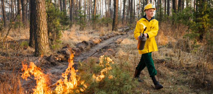
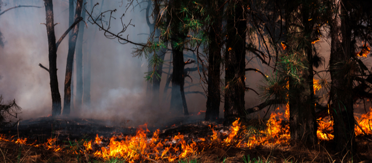
Prescribed Burn: How To Do Controlled Fires Safely
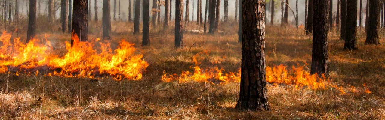
Controlled burns are widely applied in forest management; the time and frequency of prescribed events depend on their purposes. There are various reasons why controlled burning is good, but it is also challenging for foresters. In particular, flame escapes are among the most significant disadvantages of this method.
However, deep expertise, weather analytics, and proper situation control help mitigate the risk, while satellite technologies assist in prescribed fire management and forest monitoring.
What Is A Prescribed Burn?
Controlled burn is an intentional setting of forest areas on fire for ‘prescribed’ treatment, hence the term derives. Since the whole process should be thoroughly scheduled and managed, it is also called planned or controlled burning. Applying the prescribed ignition method, foresters must consider:
- area specifics,
- weather conditions,
- public health issues,
- work safety,
- purpose,
- the most appropriate time.
The burnt materials are called fuels and typically include dead vegetation, plant parts affected by tree diseases, or wood remnants after timber harvesting.
What is the point of a controlled burn? The main objective of prescribed forestland ignition is to improve forest health. Other reasons for control are forest cleaning, thinning, wildfire prevention, etc.
Controlled Burning Techniques
The most common types of prescribed forest fires are categorized according to the area covered and fall into broadcast or pile burning. Controlled broadcast burns are conducted on the whole forest area (from a few ha to several thousand ha). Controlled pile burns suggest collecting fuels in stacks (piles) and burning them separately.
Depending on the correlation of spreading flames to wind and if it occurs up or down the slope, there are the following prescribed fire types:
- backing fires,
- head fires,
- trip-head fires,
- flanking fires,
- point-source fires,
- ring fires.
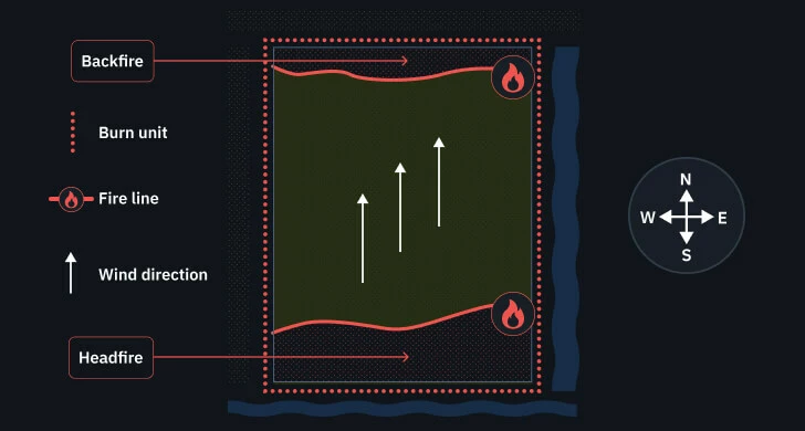
Backing Fires
Prescribed backing fire is ignited against the wind, so it moves slower, compared to other types. The relative ease of control explains the frequency of use. Because it spreads slower, the event takes longer and requires more understory fuels.
Prescribed backing fires are important in combination with other controlled burning techniques to secure safety zones that won’t ignite because all fuels have already been used there.
Head Fires
This type goes upslope or windward, so it spreads fast and produces intensive heat. Prescribed head fires have long flames. Due to its high intensity and fast speed, such controlled forest burn belongs to the most difficult types and demands extreme caution.
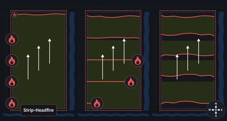
Strip-Heading Fires
Strip-heading prescribed burn bases on backing fire or firebreak with ignited strips located one by one. Controlled burn is arranged in the upwind direction from the backing fire zone or firebreak. The distance between the prescribed strips usually varies from 20 to 50 feet and is determined to ensure the timely dissipation of the flames.
Flanking Fires
A flanking prescribed burn in a forest is arranged in controlled lines, making flanks (i.e. parallel) to the wind. Thus, the flames move into the wind. The outer controlled flanks should have firebreaks for safety reasons, to avoid flame escapes. Prescribed flanking fires spread rather fast.
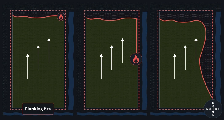
Controlled flanking fires produce middle temperatures. Prescribed head fires are the hottest, while backing ones are relatively cool.
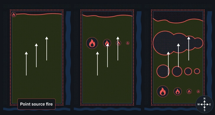
Point-Source Fires
Controlled burns in forests may be inflamed in a grid pattern to reduce the flame intensity and get better control due to unpredicted weather changes. The grid distances and ignition schedule vary depending on the desired flame intensity and allow adapting to changing fuel composition and weather conditions if necessary.
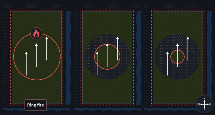
Ring Fires
Ring prescribed fire is set in the form of a circle, starting from the perimeter and moving toward the circle’s center. Controlled ring fire requires firebreaks or blackened zones, surrounding the territory, and deep personnel expertise, as the flames may escape to neighboring stands and agricultural fields. Prescribed ring fires produce relatively low smoke, so they are used when avoiding high smoke production is critical (e.g., nearby kindergartens, residential areas, schools, hospitals, airports, etc.).
How To Do A Controlled Burn
To achieve the best results, prescribed burns in forest management should be thoroughly planned and controlled. It is important to get all paperwork, permits, and licensing done in advance. Also, consider the following circumstances when the situation may get out of control:
- prescribed burn equipment is misused;
- flames spread too fast or too slow;
- smoke annoys the neighborhood;
- controlled burn schedule is developed poorly;
- firebreaks are insufficient;
- fire-managing personnel is not enough;
- controlled burn tools are missing;
- weather forecasts promise low humidity and strong gusts of wind;
- topographic specifics and fuel types are overlooked.
What Are The Best Prescribed Burn Weather Conditions?
Based on the experience of successful controlled burns implementation, the best weather conditions for prescribed burns are as follows:
| Weather condition | Recommended value |
|---|---|
| Air temperature | 40-60 degrees F |
| Relative humidity | 40-55% |
| Surface wind speed | 1-3 mph |
| Transport wind speed | 6-18 mph |
| Precipitation | 1 inch |
Still, these weather parameters are not universal and may vary depending on the case.
When planning how to do a prescribed burn, it is important to understand the weather’s impact on the intensity and spread of controlled fire.
- Air temperature. The higher the temperature, the quicker combustion. Therefore, it is prohibited to conduct a prescribed burn during the period of droughts.
- Wind. Wind speed and direction must be stable to avoid flame escapes, and the transport wind speed (20 feet above the earth’s surface) must be strong enough to ensure proper smoke dispersion.
Stability of air masses. Vertical airflows impact smoke transportation. When air masses are too stable, smoke dispersion and visibility are low. Conversely, unstable air masses promote quick smoke removal to the upper atmosphere. - Relative humidity. Because air humidity correlates with moisture content in plants and affects their inflammation property, forest prescribed burns must not take place when air humidity is too high or too low. Fuels won’t burn sufficiently when the air is too humid and will ignite faster when they are too dry. Besides, wet vegetation produces a lot of smoke.
- Precipitation. Rainfalls support soil moisture, and the earth should be relatively wet to prevent root damage and undersurface organic matter ignition.
How Often Does Forestry Do Controlled Burning?
The interval may vary from one to fifty years. Typically, controlled forest fires are conducted every year, but a burn in a hardwood forest may be done even within shorter periods. The time frameworks between the prescribed events depend on the amount of fuel, vegetation time, climatic conditions, and topographic specifics.
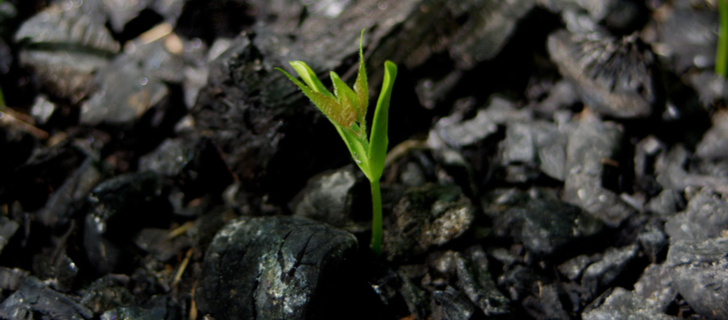
How does a controlled burn help the forest? Prescribed forest burns are an effective practice because fuel eradication minimizes wildfire risks. Therefore, forest managers apply the strategy of controlled burning to prevent forest fires. Besides, forestlands after re-growth are more suitable for wildlife.
Best Time To Do A Prescribed Burn In A Forest
Controlled forest burns usually take place in early spring before vegetation turns green – from February to mid-April or the middle of May. However, the time of the year depends on the purpose of controlled burning of forestland. Prescribed spring events help manage wildlife habitats or decrease combustive fuels. Prescribed summer events are necessary to release the seeds of fire-dependent species (e.g., pines) that won’t drop until the cone resin melts.
As for timing during the day, the event must be completed before sunset. Start fire for a prescribed burn in the forest from 10 a.m. to noon.
Controlled Burning Benefits: Why Prescribed Fire Is Good
Controlled forest ignition is justified for various reasons, and the major benefits of prescribed fire on forests are as follows:
- induced reproduction of fire-dependent species;
- prepared forestlands for reforestation;
- reduced forest fires risks and intensity with a controlled burn;
- mitigated wildfire risks by eliminating flammable fuels;
- destroyed weeds to decrease competition, including parasitic plants ;
- killed pests and pathogens to address tree diseases;
- favorable changes in forest cover after prescribed fire events;
- rejuvenated picturesque landscapes;
- released nutrients and improved soils;
- refreshed pastures for grazing.
Negative Effects Of Controlled Burning: Why Prescribed Fire Is Bad
Despite prescribed fires are generally beneficial to forest health, there are certain disadvantages of controlled burning:
- risks of flame escapes;
- health issues induced by smoke;
- released carbon dioxide from trees and forest soils;
- erosion and sedimentation due to a lack of soil cover;
- destroyed non-target plant species and wildlife.
Even though birds may perish during prescribed burns in forests, they re-nest quickly. Re-grown forests are better habitat for brooding.
Satellite Technologies To Assist In Prescribed Fires
Using fire as a land management tool requires accuracy and careful planning. Satellite data helps those who plan prescribed fires make better decisions about when, where, and how to carry them out. EOSDA LandViewer provides access to powerful imagery and analysis features that support the entire process, from preparation through post-burn monitoring.
Before the Burn: Identifying the Right Areas
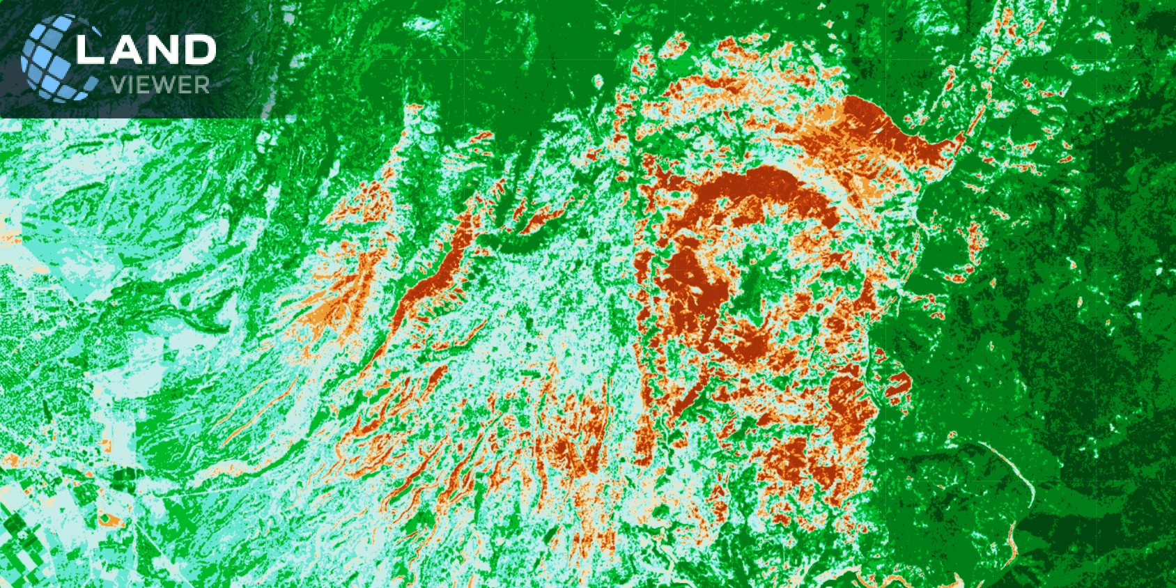
The success of prescribed burns depends on knowing which areas need treatment. EOSDA LandViewer offers satellite imagery combined with vegetation indices such as NDVI and NDMI, which help evaluate both vegetation density and moisture levels. These insights reveal zones with heavy, dry underbrush, which are ideal targets for a low-intensity prescribed fire.
With the time series analysis also available on the platform, users can study vegetation patterns across multiple seasons. This allows fire managers to choose the safest time frame and ensures that prescribed fire plans align with ecological conditions. Access to historical imagery also supports long-term planning by highlighting changes in vegetation buildup over the years.
After the Burn: Assessing Outcomes
Once a prescribed burn is completed, it is important to evaluate the results. EOSDA LandViewer provides access to imagery from different satellites, including Sentinel-2 and Landsat, which can be used to assess the severity and spread of the burn. Indices such as NBR and dNBR allow users to clearly map affected areas and determine whether the fire stayed within the planned perimeter.
Recovery can also be monitored over time. NDVI and EVI help track vegetation regrowth and show whether ecological benefits are taking hold. Users can compare imagery from different dates, visualize changes in landscape, and present these results through time-lapse animations and change detection tools. This approach ensures transparency and supports data-driven reporting.
What Happens When Threat Is Ignored
The Camp Fire, which erupted on November 8, 2018, in Paradise, California, became the deadliest and most destructive wildfire in the state’s history. Fueled by extremely dry vegetation, low humidity, and powerful Diablo winds, the fire spread rapidly and with devastating intensity. It destroyed nearly the entire town of Paradise and claimed 85 lives.
This tragedy highlights the importance of proactive fire management. Strategic burns reduce fuel accumulation and can significantly lower the risk of catastrophic wildfires. With tools like EOSDA LandViewer, it becomes much easier to plan prescribed burns in the areas that need them most, guided by accurate satellite-based insights.
Fire as a Tool
A prescribed burn requires more than ignition. It demands clear goals, ongoing monitoring, and a deep understanding of the land. EOSDA LandViewer supports every step of the process, from identifying fire-prone zones to tracking the ecological impact after the fire.
As climate conditions become more unpredictable, the ability to plan prescribed fires with precision becomes increasingly valuable. With the right data and tools, fire can be transformed from a destructive force into a powerful instrument for restoring and protecting ecosystems.
More Prescribed Burns Mean Fewer Extreme Wildfires
When implemented with due precaution, controlled fire can do a lot of good. Apart from benefits for forest health, it is an effective practice to control and prevent forest ignition. By destroying combustible fuels in time, foresters mitigate the risks of potential wildfires by up to 72% , yet we should never forget why controlled burning is bad.
Proper situation management is possible with ongoing forestland observation, and EOSDA LandViewer is a reliable assistant in this regard. Request a demo or learn more about our product features from the sales department at sales@eosda.com.
About the author:
Vasyl Cherlinka is a Doctor of Biosciences specializing in pedology (soil science), with 30 years of experience in the field. He attended the engineering college in Ukraine and received his degree in agrochemistry, agronomy and soil science in the Chernivtsi National University. Since 2018, Dr. Cherlinka has been advising EOSDA on problems in soil science, agronomy, and agrochemistry.
Recent articles

EOSDA Forecasts Yields For 2025 In Saskatchewan
EOSDA created RM-level crop yield forecasts for Saskatchewan to address limitations of official data. The project shows how satellite and weather inputs reveal local yield changes during the season.

Digital Tools Improve Soil Health And Yields In Mexico
EOSDA and ITTA supported a Guanajuato farm with contour-line planning, monitoring tools, and practical guidance to reduce soil erosion and improve yields in the long run.

Analyze 2025 & Plan Your Best Year Yet: LandViewer Christmas Offer
It’s the most wonderful time of the year! The Christmas holidays are here, and so is your chance to analyze 2025 and plan a prosperous 2026 with more affordable Pro plans in LandViewer.