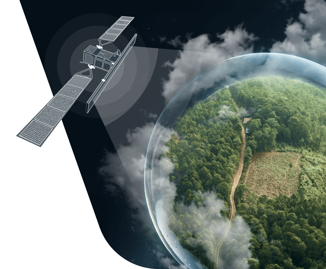
Forest Monitoring Using Remote Sensing: Solution By EOSDA
EOSDA Forest Monitoring system utilizes satellite technology to ensure advanced forest health assessment. Perform comprehensive and remote management of your stands in one digital tool.
What Makes Our Forest Management System Unique
In-house R&D department
Up to 90% accuracy
Development of new solutions
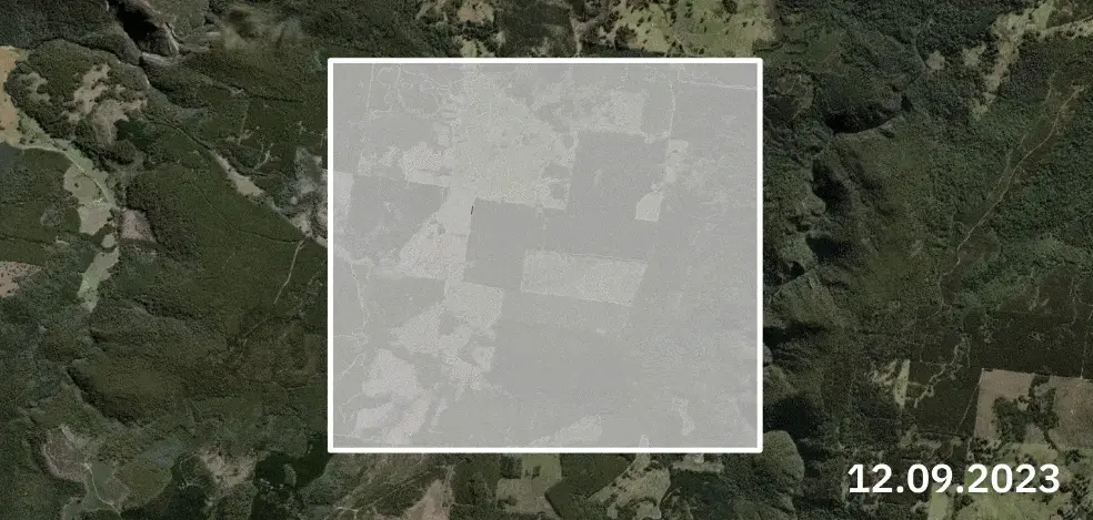
Comprehensive forest cover monitoring based on images from Sentinel-2, Sentinel-1, EOS SAT-1, and other satellites
Adjustment to customer requirements
Forest cover change detection based on data since 2018 (since 2000 for some stands).
Frequency of satellite images tailored to client's needs and budget.
Data delivery available via platform, customizable reports, API, file sharing, email, or other.
Steps Of Our Cooperation Process
Customers submit their project details for our evaluation, including AOI file, objectives, expected outcomes, and other relevant information.
After a thorough review, EOSDA will offer a solution's description, including time and cost estimates.
Upon client confirmation, EOSDA will deliver the project results within the agreed terms.
Forestry Monitoring Software By EOSDA Entails:
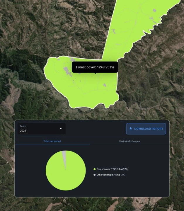
Forest Cover Monitoring
Review both past and present data on your stands to detect changes in forest cover within your area of interest (AOI).
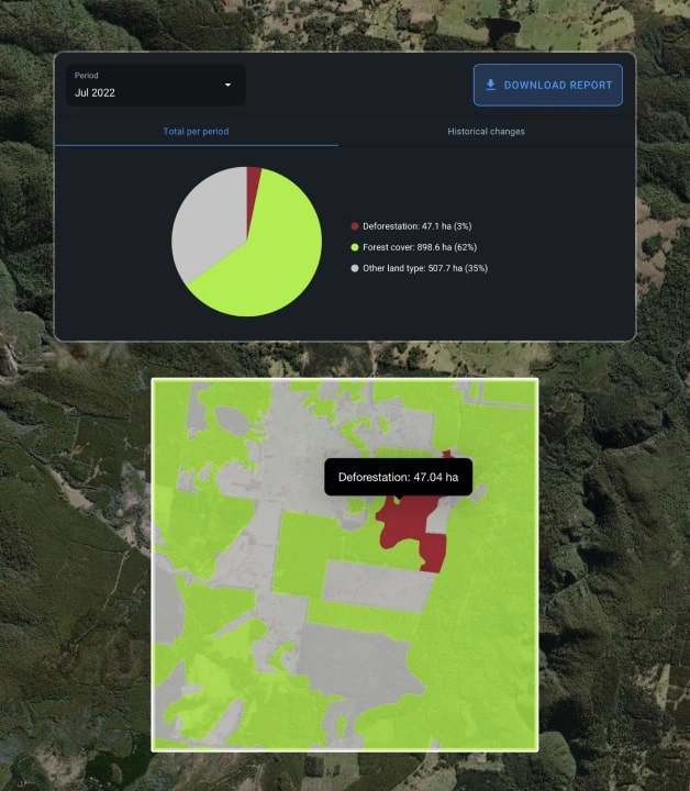
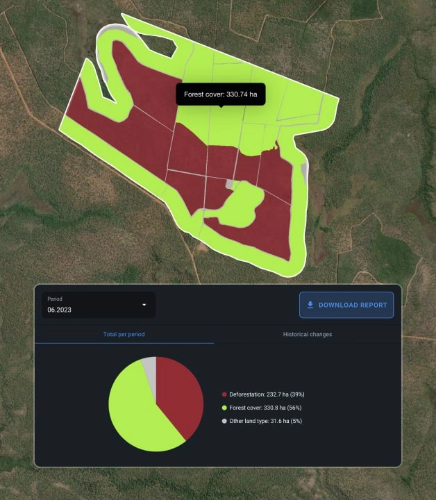
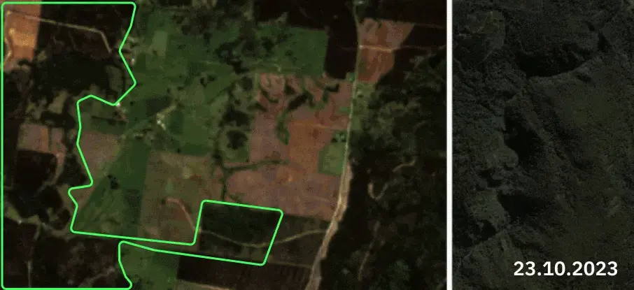
Deforestation Monitoring
Get insights into the extent of deforested areas within your stands to:
- Identify illegal clearcuts.
- Evaluate damage from natural disasters like hurricanes or fires.
- Analyze historical logging activities.
- Estimate financial losses from deforestation.
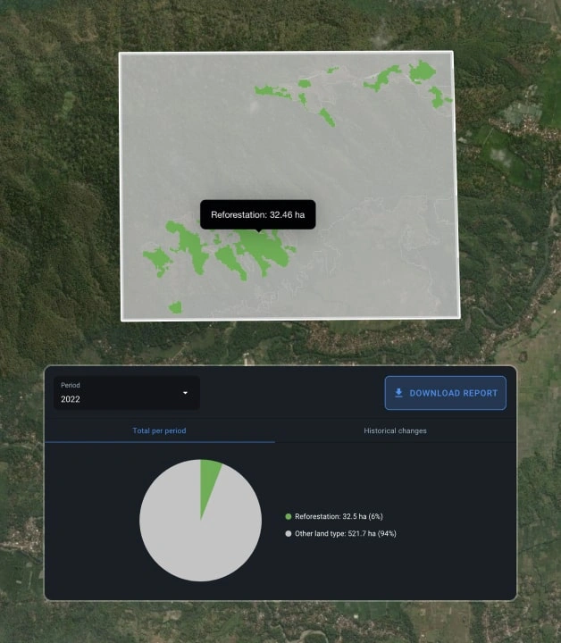
Reforestation Monitoring
Identify land cover changes, track tree growth and replanted areas to coordinate reforestation efforts in commercial forests and support eco initiatives aimed at combating erosion and preserving biodiversity.
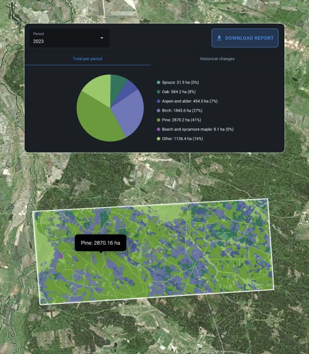
Tree Species Classification
Identify tree species like oak, birch, pine, and others with up to 80% accuracy to:
- Classify tree species across your AOI.
- Enhance inventory management .
- Analyze species distribution and coverage in your AOI.
* Solution requires ground truth data
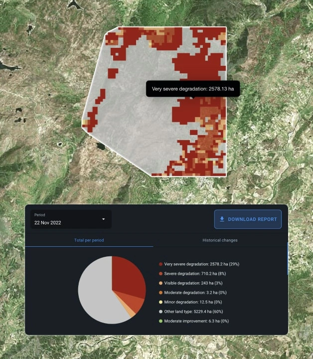
Forest Health Monitoring
Detect changes in your forest health based on Sentinel-2 or MODIS satellite imagery data. We compare and analyze historical (over 3, 5, 7 years) and current NDVI values for specific areas. Assessments occur every 8-10 days to 1-2 months, varying by satellite and region.
Our reports categorize forest health changes across 11 stages, allowing for an overall assessment of forest health and its changes due to natural phenomena, reforestation activities, etc.
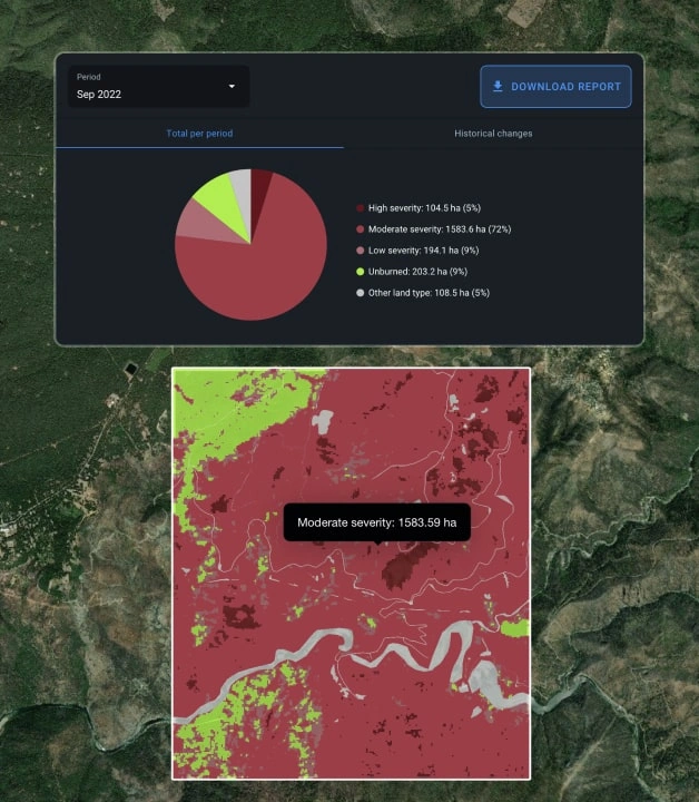
Burned Area Estimation
Effectively manage post-fire activities on regional and country-level based on severity of damage in each zone. Whether it’s small or large forest fire monitoring, this approach allows for evaluating the damage and classify burned areas depending on the degree of tree burnout through pre- and post-fire satellite images to:
- Predict forest recovery period.
- Manage reforestation efforts by area.
- Identify zones for removing dead trees.
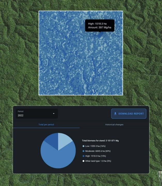
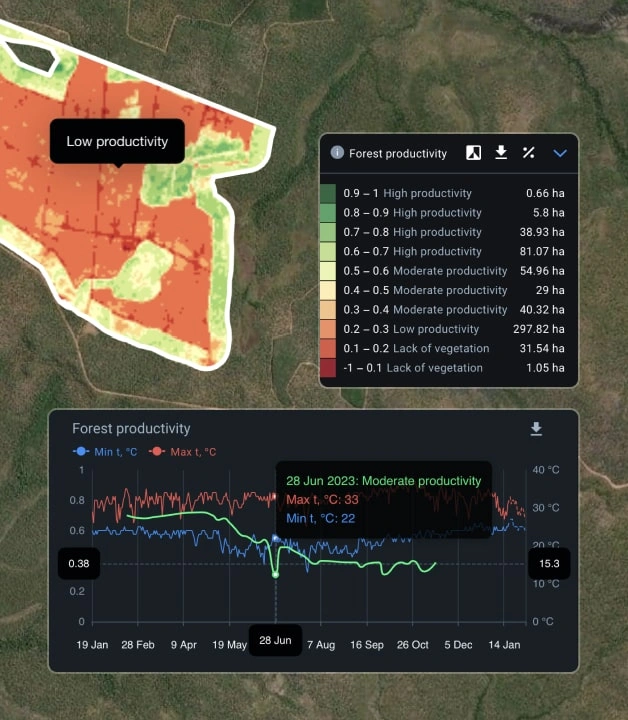
Biomass Estimation
Estimate your forest biomass based on current and historical data analysis to:
- Prepare inventory data.
- Prepare data for receiving carbon credits.
- Assess forest productivity.
- Assessment of timber stock for purchase or insurance.
* Solution requires ground truth data
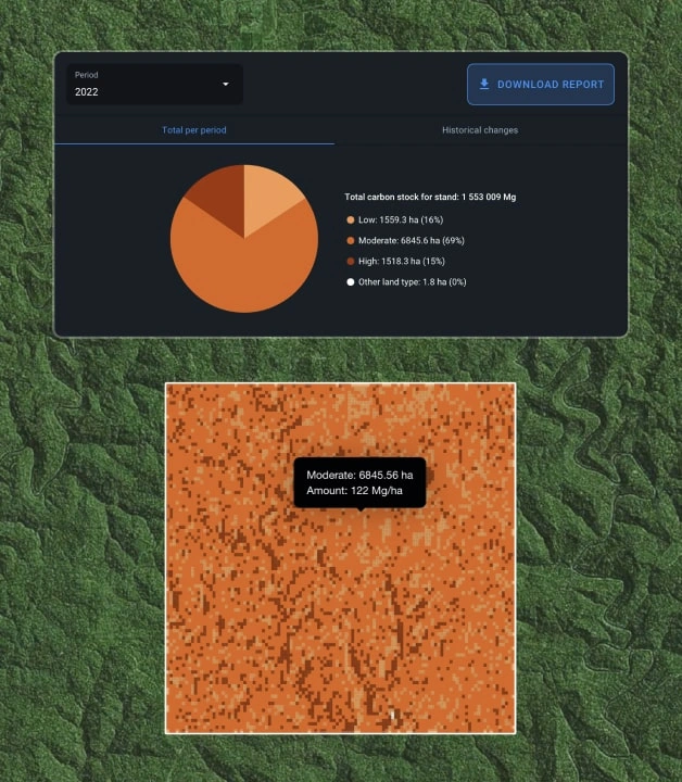
Forest Carbon Monitoring
Generate carbon stock reports based on biomass estimates to combat global warming and earn carbon credits. Data on carbon amount is measured in megagrams and is updated at least yearly to help:
- Estimate carbon stock in forests.
- Assess carbon stock in timber for purchase or insurance purposes.
- Conduct ecological research on land cover carbon stock.
* Solution requires ground truth data
EOSDA also offers a soil organic carbon modeling custom solution.
Supply Chain Management
Improve supply chain management by monitoring and analyzing deforestation data in your own or neighboring stands. Use this information to:
- Verify compliance with EUDR standards.
- Distinguish between primary and newly planted forests.
- Track changes in forest boundaries.
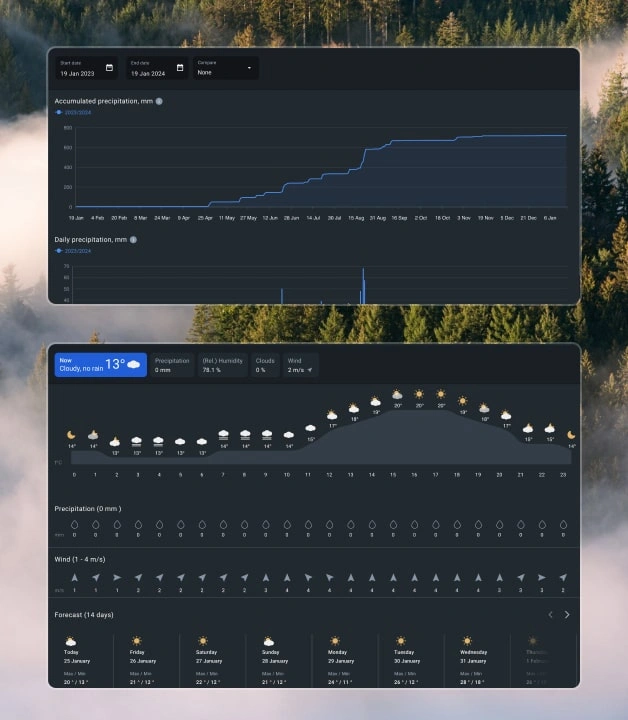
Weather Monitoring
Get detailed weather data, including temperature, precipitation, radiation, evapotranspiration, wind strength and direction, etc. Use historical analysis and a 14-day hourly forecast to:
- Plan and adjust activities.
- Detect weather threats like high temperatures and low precipitation to prevent wildfires.
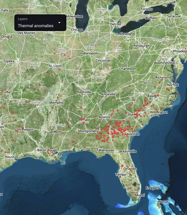
Thermal Anomalies Detection
Be aware of wildfires in your area thanks to the NASA FIRMS digital map to plan your forest protection actions if necessary.
Vegetation Monitoring
Perform remote forest health monitoring using NDVI, NDMI, MSAVI, NDRI, and RECI vegetation indices. Data is updated every 5-10 days based on the area. Our R&D team can also create custom indices tailored to your particular needs.
Tracking changes in index values helps you to:
- Regularly monitor vegetation changes in your stands.
- Analyze historical data to identify trends of vegetation growth or decline in specific zones.
Forestry Software For Loggers: Optimizing Operations Of A Logging Company
Problem:
A Tasmanian logging company traditionally measured their logging progress through manual assessments conducted by various crews. This has led to a lack of precise, comprehensive data regarding the location and volume of harvested timber. Additionally, determining the profitability of logging activities in different regions required extensive inventory assessments, a process that proved to be quite time-consuming.
Solution:
- Automated monthly timber harvest reports based on satellite imagery data:
Leveraging Earth observation satellites to monitor harvesting activities means a unified tool with standardized metrics is used for precise progress evaluation.
- Tree species identification within an AOI
EOSDA Forest Monitoring software uses satellite imagery analysis to distinguish between tree species in forests. This facilitates forest inventory management, enables forecasting of potential revenue from timber sales, and enhances productivity of underutilized land by selecting the optimal species for each area.

Success Stories
The Decades-Long Story Of Saamaka, The Forest Defenders
This story of impact delves into the Saamaka people's struggles and triumphs against deforestation and legal obstacles, aiming to secure their ancestral forests in Suriname.
Greening The Planet: Satellites’ Role In Afforestation
Utilizing satellite monitoring to track reforestation ensures tree planting projects' transparency and increases user engagement. EOSDA Crop Monitoring helped Evertreen improve customer retention and strengthen sales with value-added service.

EOSDA Technologies Help Meet Modern Forestry Challenges
Forico - Tasmania’s leading forestry management company - upholding its standards of quality and meeting new market challenges by implementing innovative satellite-driven EOSDA solutions.