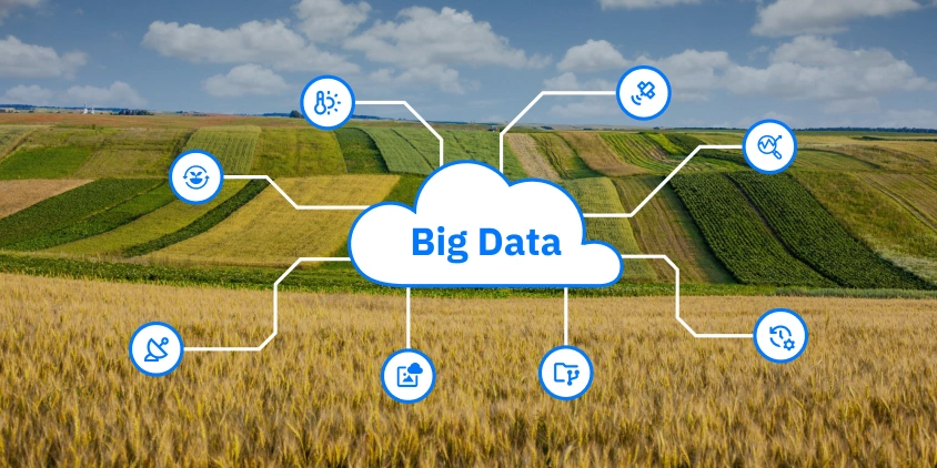
Big Data In Agriculture Backed By Satellites & Sensors
A lot happens in the field every growing season. Crops react to a unique combination of heat, moisture, nutrients, diseases, and management practices in a way that’s hard to predict. Farming big data, powered by satellites, soil sensors, and machinery records, helps understand and manage the effects of these factors. Say, a satellite image reveals an area under stress; a nearby soil sensor explains why.
Farmers, using big data in agriculture, don’t need to guess or wait for problems to spread. This isn’t a magic pill, but it helps farmers act with more certainty and learn from past mistakes.
What is big data in agriculture?
Big data is a term for very large and complex sets of information that are too big or fast-changing to be handled by basic analytics tools. It keeps coming in nonstop from different sources and needs special technology to make sense of it. The main sources of big data in farming are:
- agriculture satellite images showing field details and crop health;
- weather readings that help track rain, temperature, and winds;
- sensors in the agriculture machinery or placed in the soil to monitor moisture, acidity, and other key parameters;
- records from past seasons about planting dates, crop rotations, yields, and treatments.
Understanding and using big data takes time and the right tools, but it gives agriculture stakeholders a clearer view of what’s happening across each farm, and what actions might work best next.
Benefits of big data in agriculture
When used properly, precision agriculture big data brings clear, measurable benefits to farming:
- better use of time and inputs thanks to optimized fieldwork and variable rate applications;
- minimized overuse of chemicals and reduced pollution;
- higher yields due to more timely and targeted treatments (so-called sustainable intensification) ;
- risk preparedness and mitigation based on data-backed forecasts.
How does big data improve farming?
Big data analytics in agriculture helps not just react to problems but see them coming. By looking at past season patterns and current crop, weather, and soil readings, they can spot early signs of drought, pests, or disease. This means they can act sooner and avoid bigger losses. While farming stays risky, big data limits threat effects in a way that was impossible before.
Common uses of big data in agriculture
Big data in agriculture means collecting tons of details, from satellite images to machine readings, and using them to guide key decisions during the growing season. It can help identify both potential risks and the causes of long-term problems that are not obvious to farmers. The application of big data analytics in agriculture means relying on real facts to make better decisions for each field area.
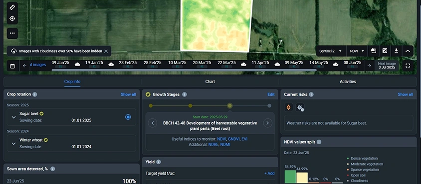
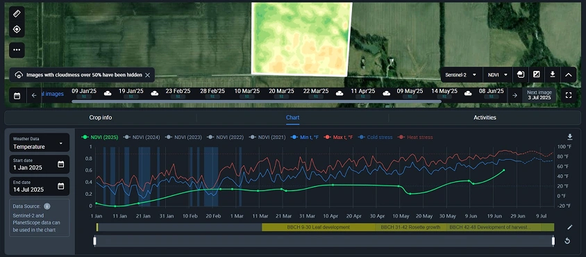
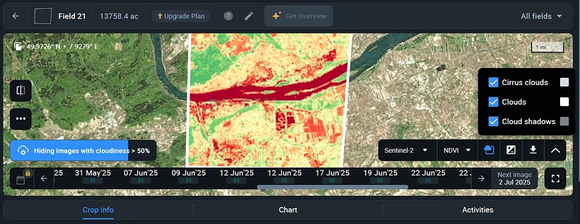
Satellite imaging for crop health assessment
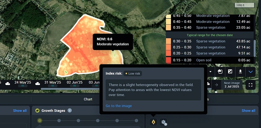
A large part of agricultural big data analytics comes from satellites. They scan fields every few days and gather images in different spectral bands, processed into vegetation indices to show how fast and well the crops grow across entire fields. A farmer can use these satellite-derived insights, for example, to determine which areas of their fields require watering or fertilizing.
Precision agriculture platforms
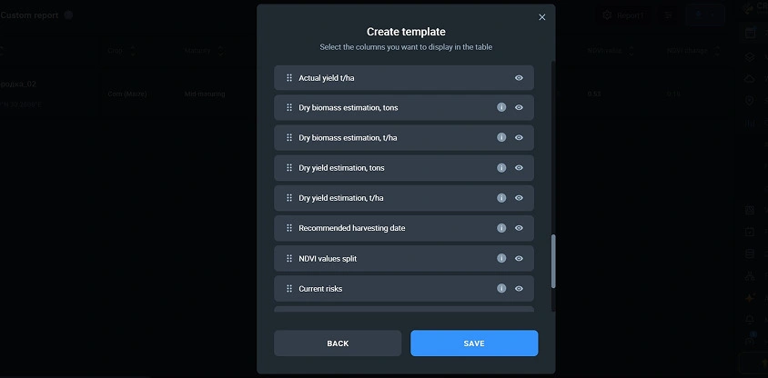
Precision agriculture platforms use big data to give farmers a full picture of what’s happening in their fields. For instance, EOSDA Crop Monitoring combines satellite images, weather analytics, field activity records, and agriculture machinery readings all in one place. A farmer can zoom in on each field to see stressed areas and take immediate action. Our precision agriculture software also helps track and analyze historical field productivity so that farmers can solve lasting problems like soil drainage or rethink crop rotation.
Yield prediction and analysis
Crop yield prediction is one of the most practical uses of big data in agribusiness. Specialized mathematical models can accurately estimate future yields based on weather records, satellite-derived vegetation indices, soil parameters, and field history. These predictions support planning (e.g., choosing crops that suit the season or deciding the best planting dates). As demand for higher accuracy and scalable big data farming platforms grows, the market for machine learning in yield prediction is expanding rapidly, with an expected annual growth rate of 26.5% through 2032 .
Pest and disease control
Big data helps agriculture producers prevent pest and disease outbreaks instead of reacting after damage is done. Advanced algorithms process weather records, crop growth stage, and past infestations to predict where and when problems might occur. This allows for early, targeted treatments, lower in cost and more friendly to the environment.
Water and energy management
Instead of watering fields on a set schedule, farmers can use precision agriculture big data to respond to what the crops actually demand. Soil sensors, satellite imagery, and local weather stations guide irrigation, minimizing waste when rain is expected or when only the topsoil is dry. In Brazil, this has already helped farmers reduce water consumption by up to 30% . Energy savings stem from fewer pump hours and shorter irrigation cycles, meaning significantly cut costs per hectare.
John Deere Precision Ag Technology
John Deere, a well-known manufacturer of agriculture machines, uses big data in a very hands-on way. Their tractors, sprayers, and combines come with built-in GPS and sensors that gather details on soil moisture, nutrient levels, yields, etc. while working in the field. Farmers can see these records on a digital platform and adjust their field operations accordingly.
Challenges of using big data in agriculture
Big data analysis in agriculture is promising. However, applying it in practice isn’t always simple, since satellite and sensor data can be incomplete or vary in quality, and organizing it requires skill. Without using ready-to-go precision agriculture platforms, it can be hard for farmers to turn raw data into practical decisions.
Limitations for small farmers
Using big data directly on small farms is often impossible. Building a platform for big data in agriculture from scratch is expensive and needs a team with technical skills, which most small and medium-sized farms simply don’t have. Even if the records are available, they still need to be processed into something useful.
One of the most realistic ways to solve this problem is to use ready-made precision agriculture platforms. EOSDA Crop Monitoring, as one such platform, does all the heavy work — gathering satellite images, analyzing them, and showing only the most important results. It puts the key information in front of small and medium-sized farmers in a simple form so they can take action fast.
Variable satellite data quality
Interference from clouds, haze, or shadows during satellite observation might lead to incomplete or distorted data. Fortunately, automated processing algorithms (used in most modern precision agriculture platforms) can detect and filter out poor-quality images. This reduces the risk of false conclusions and improves the reliability of satellite-based insights.
Handling big data from multiple sources
Big data and other agriculture information typically come in different formats and levels of detail. Some may update in real time, while other comes in batches. If not organized properly, this makes it hard to get a clear picture of what’s happening in the field.
To deal with this, EOSDA Crop Monitoring brings all this information into one place. We collect satellite images, weather records, field activity logs, and more, and display them in a format that is easy to read and use. Everything is stored in the cloud, thus accessible from anywhere and safely archived for future use. This kind of setup helps farmers see the full picture and make better decisions without switching between multiple tools.
Need for technical and agronomy expertise
To benefit from big data in precision agriculture, farmers or agronomists need to know how to read satellite images, choose the right vegetation indices, and understand the meaning of changes in crop health maps. That calls for skills in both big data analysis and crop science, something many farms lack.
Digital agriculture platforms aim to fill this gap. For instance, EOSDA Crop Monitoring offers ready-to-use insights based on crop type and growth stage. Farmers receive clear guidance, like which index to use at a certain crop growth stage, what NDVI value is normal, or when a specific field might be at risk of disease. So, they can act in time, based on accurate information, and without needing deep technical knowledge.
For big data to matter in agriculture, it has to help farmers cut through complexity. As more intuitive platforms emerge, the focus shifts from more records to more insights. Only then will the full value of big data be realized across all scales of agriculture.
About the author:
Kateryna Sergieieva has a Ph.D. in information technologies and 15 years of experience in remote sensing. She is a Senior Scientist at EOSDA responsible for developing technologies for satellite monitoring and surface feature change detection. Kateryna is an author of over 60 scientific publications.
Recent articles

EOSDA to Monitor Wildfires in Portugal Using Satellite Data Under ESA’s InCubed Programme
The company signed a contract with ESA to create an innovative satellite-based solution for forest monitoring and wildfire prevention.

EOSDA Forecasts Yields For 2025 In Saskatchewan
EOSDA created RM-level crop yield forecasts for Saskatchewan to address limitations of official data. The project shows how satellite and weather inputs reveal local yield changes during the season.

Digital Tools Improve Soil Health And Yields In Mexico
EOSDA and ITTA supported a Guanajuato farm with contour-line planning, monitoring tools, and practical guidance to reduce soil erosion and improve yields in the long run.