Land cover classification using satellite data and deep learning
Comprehensive land cover classification backed by remote sensing and deep learning by EOSDA for environmental monitoring, agricultural zoning, and strategic planning.
- Up to 90% accuracy across seven key surface cover classes with Sentinel-2 imagery
- Custom ML architecture trained with 10-band spectral imagery for high precision
- Actionable outputs, including raster land use classification maps, area stats, and optional reports

Benefits of the land cover classification solution by EOSDA
- Environmental monitoring and conservation (tracking ecosystem changes, deforestation, urbanization, and supporting biodiversity assessment).
- Urban and regional planning (infrastructure planning, and resource allocation).
- Support of natural resource management (water resource utilization, mineral exploration, etc.).
- Agricultural monitoring & food security (identification of cropland area and changes, fallow areas analysis).
- Policy formulation & compliance (support for national/ international reporting on ground and water utilization and environmental targets).
Approach and Methodology
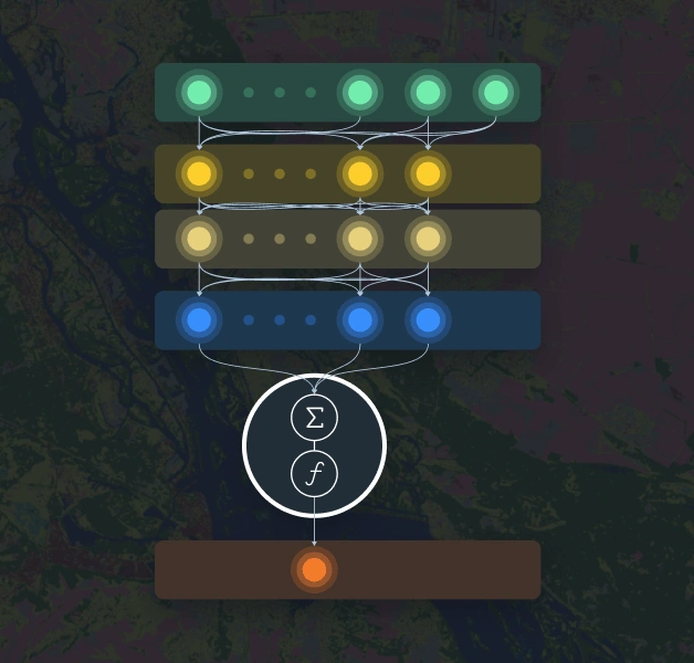
Model: ML architecture consists of a custom fully connected regression model (FCRM) for each class.
Satellite data: The model for land cover classification utilizes Sentinel-2 L2A satellite images, applying 10 spectral bands.
Supported classes: 7 key surface cover classes, can be trained for additional classes.
Accuracy: up to 90%.
Limitations: Regions with high cloud cover, objects smaller than 30-50 meters in length/ width.
Expected project outputs and formats
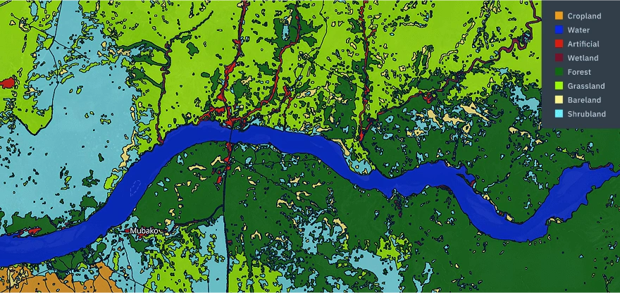
- Raster mask of classification with target classes cropped by target AOI (GeoTIFF): Bareland, Artificial, Water, Forest, Grassland, Wetland, Cropland.
- Aggregated statistics of areas per ground use class by admin boundaries of regions, districts, etc. (xlsx, csv), if required.
- Analytical report or results interpretation note, if required.
Data required for the land use classification project
Inputs from the customer
- Area of interest: table (xlsx/ csv) or vector format (KML, ESRI shapefile, GPKG, GeoJSON)
- Ground truth data for model training/validation (optional, if available)
Data prepared by EOSDA
- Satellite imagery
- Other additional data layers (cities, roads, water bodies, etc.)
- Validation datasets
Standard project stages
Typical project duration: 2-4 weeks.
Investigation of vegetation features for AOI.
Class labeling on AOI for training and validation.
Search and download the required satellite data.
Model launch and support/control.
Result verification and preparation of final outputs.