Grid Soil Sampling & Its Role In Precision Agriculture
Fertilizing decisions made from average field health and nutrient levels treat all soil as equal and thus make farmers lose yield and money. Grid soil sampling approaches field variability systematically, helping farmers capture any differences that influence crop productivity. The cost of pulling more samples is offset by avoiding blanket fertilizer applications that overspend in some areas and underfeed others. Satellites make the process planning faster, for example, by showing patterns of plant growth that typically mirror soil variability. Over time, systematic grid sampling reveals patterns and trends in the field for the most efficient soil management.
What is grid soil sampling?
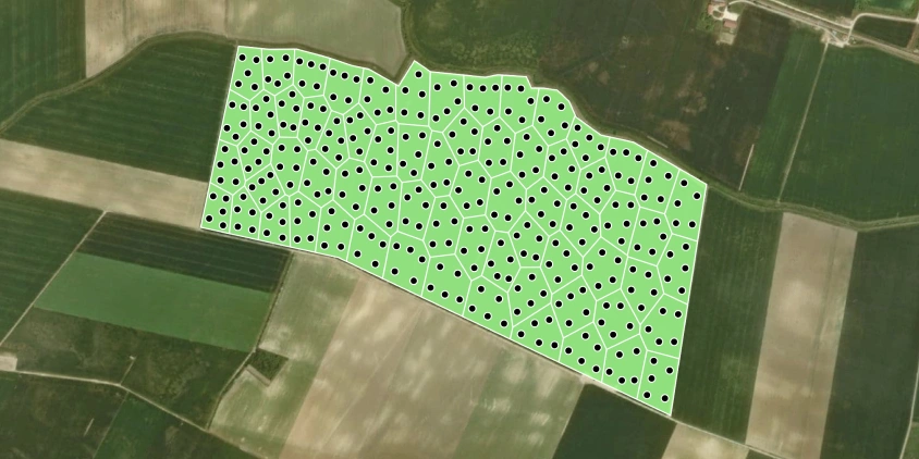
Grid soil sampling is the process of breaking a field into equal-sized cells and testing soil from each one. The field for soil testing is divided into small cells, say, 1.5-acre (0.6-ha) or 2.5-acre (1-ha) size. The study in the Southeastern US found accuracy highest at over 80% with a 1.0-acre (0.4-ha) grid, decreasing to about 76% for 2.5 acres (1 ha) and 73% or less for larger grids . However, cells smaller than 1.5 acres (0.6 ha) are rarely used because applying products at such a resolution is challenging for most machinery.
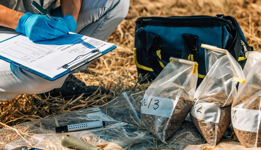
In each cell, 10–15 soil cores are taken from evenly spaced points and sent to a laboratory. The laboratory measures nutrient (and sometimes micronutrient) levels, pH, organic matter, and some other parameters important for a particular area. This information is tied to the GPS location of each cell to create detailed soil maps, guiding precise input application and improving nutrient management.
Are there any disadvantages of grid sampling?
Although grid soil sampling is widely used, there are a few points to keep in mind. Because probes are taken at evenly spaced points, the total number can be quite high, which raises the time and cost needed for both collection and laboratory work. In some cases, this is the main factor limiting how densely the probes can be taken.
Determining the correct spacing is another nuance. A coarse spacing might not capture smaller problem spots, but a very dense spacing might produce more data (and more expense) than is truly necessary. Experience with the field, along with past yield or soil maps, can help in choosing a sensible cell size.
Lastly, the results often come in the form of complex datasets. Turning these into actionable recommendations can require grid sampling analysis software or advice from an agronomist — another step before the data can be applied in the field.
Grid sampling in precision agriculture
In precision agriculture, grid soil sampling is used to map how soil properties vary within a field. Resulting maps reveal differences in fertility that traditional field testing with composite probes can overlook, making it possible to apply P and K fertilizer, lime, or other amendments where they will pay off . These precision agriculture maps help improve nutrient use efficiency, support more even crop growth, and reduce the risk of nutrient loss to waterways.
Grid sampling vs. zone sampling
Grid and zone sampling methods follow different approaches to collecting data. In grid sampling, probes are collected at evenly spaced points across a field, which is reliable even when the field variability is unknown. The trade-off is the number of probes required: in large operations, the workload and lab costs can be significant. Grid testing often generates the highest ROI when used for high-value cash crops .
Zone testing, on the other hand, organizes a field into separate management areas before collecting probes. Zones are defined using data such as soil type, yield history, elevations, or satellite-derived vegetation maps. Probe collection is then limited to representative spots within each zone. This approach reduces costs and effort but relies heavily on the accuracy of the zoning process.
Ultimately, grid sampling provides high-resolution soil data with a higher price tag, while zone testing gives less detail at a lower price. This makes the farmer’s choice dependent on available budget, historical data, and the degree of variability in the field.
Using EOSDA Crop Monitoring for accurate grid soil sampling
EOSDA Crop Monitoring allows farmers to prepare precise soil sampling plans without spending extra time in the field pre-sampling. Our satellite-driven agriculture platform covers about 95% of the world’s farmland, so fields in remote or hard-to-access locations can still be planned for testing with the same accuracy as those nearby.
Tailor grid soil sampling to the needs of your field with EOSDA Crop Monitoring with these steps:
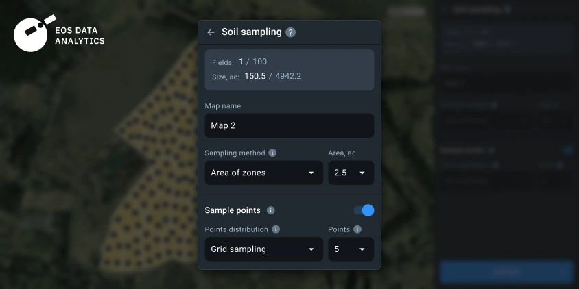
- Log in to your account and select the Soil sampling tool in VRA maps.
- Set the field division method, either by area or by the number of zones.
- Choose Grid sampling from the drop-down list of Points distribution methods.
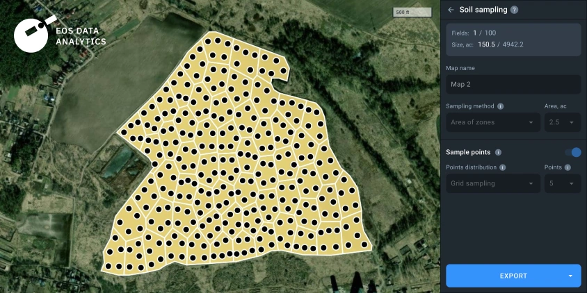
- Generate the map with clearly marked GPS coordinates for each point.
- Export the map in SHP or KML format, ready for use with GPS-guided agricultural machinery and devices.
- Collect the probes at the marked points and test them in a laboratory.
Once laboratory results are ready, they can be uploaded back into the platform via the Data manager. This not only keeps the testing data organized but also allows the results to be combined with other EOSDA Crop Monitoring data and tools. For example, you can create a new VRA map for variable rate fertilization based on actual nutrient levels, ensuring that inputs are applied sustainably.
The advantage of grid sampling grows with time. The first cycle test tells you where you stand; the second, third, and fourth tell you how the field is changing and whether your inputs are working as planned. Satellite images, yield data, and past field notes can all be layered on top to explain why certain areas behave differently and build an ongoing feedback loop.
About the author:
Maksym Bohomolov leads the product strategy for EOSDA Crop Monitoring. With a Master’s degree in International Marketing and firsthand experience at global companies like Mondelez International, he combines strong market and tech expertise. At EOSDA, Maksym focuses on using satellite analytics and AI technologies to deliver real value to farmers and agri-businesses worldwide.
Recent articles

EOSDA to Monitor Wildfires in Portugal Using Satellite Data Under ESA’s InCubed Programme
The company signed a contract with ESA to create an innovative satellite-based solution for forest monitoring and wildfire prevention.

EOSDA Forecasts Yields For 2025 In Saskatchewan
EOSDA created RM-level crop yield forecasts for Saskatchewan to address limitations of official data. The project shows how satellite and weather inputs reveal local yield changes during the season.

Digital Tools Improve Soil Health And Yields In Mexico
EOSDA and ITTA supported a Guanajuato farm with contour-line planning, monitoring tools, and practical guidance to reduce soil erosion and improve yields in the long run.