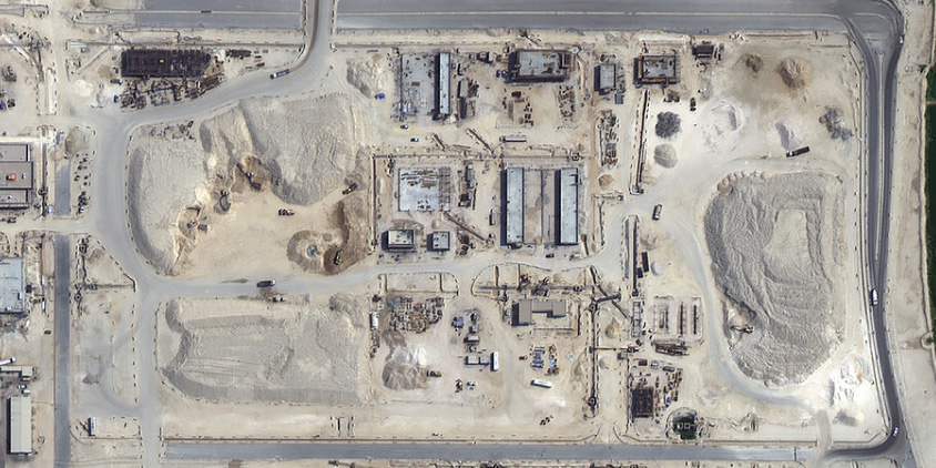
To keep a large project on schedule, you need a clear view of the entire site. Yet, traditional construction site monitoring still relies on slow site walks, security cameras with bad angles, or drones that need an on-site operator. These tools leave too many blind spots for remote managers.
This guide compares the actual value of ground tools versus orbital tracking. We show how high-resolution satellite imagery changes the game for construction monitoring. You will learn how to monitor overall progress, track logistics, and prove completed milestones without extra travel.
Key takeaways
- Traditional methods for monitoring construction sites like site walks, security cameras, and drones leave blind spots and can’t scale for large or remote projects.
- High-resolution satellite imagery offers a macro-level view that ground tools can’t match, capturing entire sites without hardware installation or on-site staff.
- Cameras, drones, and satellites each serve different purposes: cameras handle security, drones capture close-up detail, and satellites provide full-site visibility for construction site monitoring.
- Free medium-resolution imagery (10–30 m per pixel) is too blurry for construction tracking, while commercial high-resolution options (down to 0.3 m) reveal machinery, materials, and progress clearly.
- Benefits of satellite-based construction tracking include unlimited scalability for mega-projects, no need for on-site equipment, an unalterable historical archive, and SAR technology that works through clouds and darkness.
- LandViewer simplifies construction site monitoring with a rich historical archive and custom satellite tasking for time-sensitive updates.
What modern construction site monitoring looks like
Construction site monitoring means capturing site activities in a form someone can review later, from anywhere, instead of relying on memory or a verbal update. While now it points toward digital remote sensing, traditionally, it required physical presence.
That traditional approach breaks down on today’s fast-moving mega projects, 98% of which still run over budget and 77% over schedule . What’s needed to fix this is monitoring construction progress that doesn’t wait for someone to walk over, one that runs continuously and covers the site as a whole.
Ground-level site monitoring tools alone can’t deliver that, because:
- A site report is a subjective read of the situation. Nearly a third of project managers say over half their project data is unreliable, and it costs them over $88.69 million .
- A fixed camera only shows the angle it’s pointed at and stops showing anything once a wall, crane, or stack of materials blocks the view.
- A single sensor monitors a single thing — one machine, one zone — and says nothing about the rest of the site.
To make sense of all these scattered data points, project leaders need a reliable anchor: a macro-level perspective from the highest possible vantage point. Optical satellite imagery provides this. By capturing the entire construction site from orbit, satellite data cannot be tampered with, blocked by new structures, or disabled by local power failures. It ties all other site data together, offering an unalterable, site-wide truth that keeps subcontractors accountable and remote decision-making accurate.
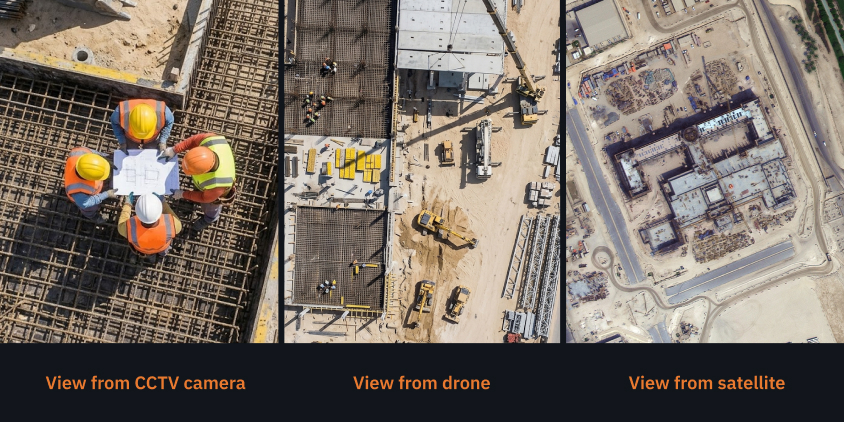
Comparing ground cameras, drones, and satellites for construction site monitoring
No single monitoring tool covers everything a construction project needs to track. Cameras, drones, and satellites each solve a different part of the problem — security, close-up detail, or full-site visibility. The table below lays out how they compare and where each fits best.
| CCTV and AI cameras | Drones (UAVs) | High-res satellites | |
|---|---|---|---|
| Best uses | 24/7 site security and theft deterrence | Close-up inspections and 3D modeling | Macro-level progress monitoring and mega-project logistics |
| Benefits | Continuous recording, AI threat alerts, and active deterrents | Multi-angle HD data, no worker risk at height | Remote, no on-site hardware, full historical timeline |
| Scalability | Low: tied to installed hardware | Medium: limited by flight range and battery | High: seamless global coverage in a single pass |
| Limitations | Blind spots, depends on site power/network | Needs on-site pilot, weather- and battery-limited | No real-time video feed, frequency tied to orbit revisits |
CCTV and AI cameras are built for security, not construction progress monitoring. A camera watching a gate or a material yard can flag movement at 3 a.m. and trigger an alarm before anything is stolen. But its coverage only extends as far as the last cable was run. Add more zones, and you need more hardware, more maintenance, more footage to review.
Drones close the gap cameras leave in height and angle. A single flight can capture a roof or a facade from several angles without putting a worker on a ladder. The trade-off is that a drone still needs a certified professional on-site to fly it, a charged battery, and weather that cooperates. None of that scales to a wide project — a drone is not a tool for monitoring the whole construction site day to day.
Satellite imagery covers what neither ground tool can: the entire site in one pass, with nothing to install and no one to send out. So, it scales without added cost as a project grows — a 50-acre construction site and a 500-acre corridor are monitored the same way. Its limitation is frequency: images arrive on a revisit schedule, not as a live feed. For security, this matters. For monitoring construction progress against a schedule, it doesn’t — a project’s shape rarely changes hour to hour, only day to day or week to week.
Why medium resolution fails at construction monitoring
Many project managers looking into remote construction monitoring start with free public imagery like Sentinel or Landsat, hoping to save on overhead. It seems like a logical, budget-friendly first step — but it almost always ends in disappointment.
The issue isn’t the technology itself; it is a mismatch of scale. To successfully monitor construction progress remotely, you must understand the difference between medium-resolution and high-resolution images and choose the right ones.
10 meters per pixel, and what gets lost in it
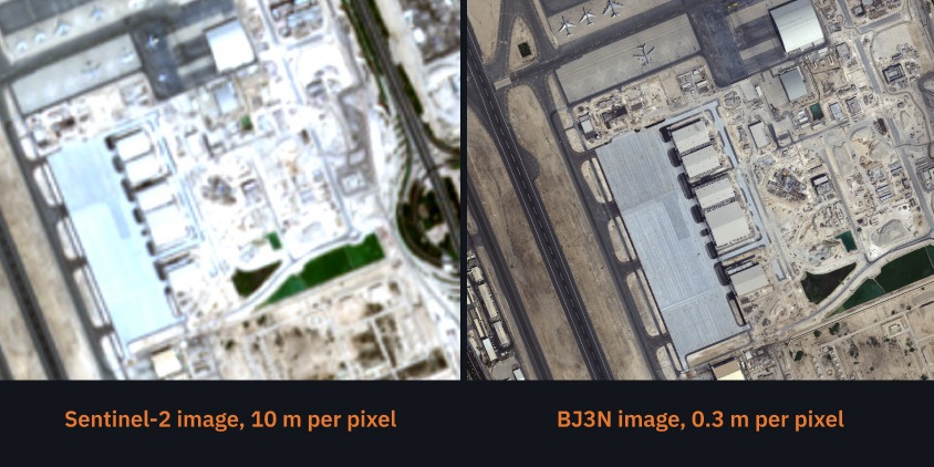
Sentinel-2, Landsat 8, and other open-source satellites typically capture data at 10-meter to 30-meter resolution. In simple terms, one pixel on your screen covers a 10m x 10m (about 33ft x 33ft) patch of real ground — roughly the size of a two-car garage.
If you try monitoring a construction site at this spatial resolution, your entire multi-million dollar footprint shrinks down to a handful of blurry, colored squares. At 10 meters per pixel:
- an entire fleet of bulldozers and excavators is completely invisible;
- a newly poured foundation looks like a vague, gray smudge;
- earthworks, trenching, and raw material stockpiles blend seamlessly into the surrounding dirt.
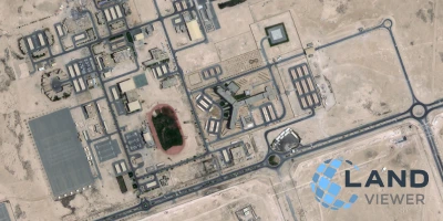
While medium-resolution imagery is highly valuable for tracking massive regional events, like urban growth or major transport corridor expansion, remote construction site monitoring requires a level of detail that only commercial high- and ultra-high-resolution satellites can provide. To understand what this difference looks like in practice, look at how the exact same construction site at Hamad International Airport in Doha appears under different resolutions.
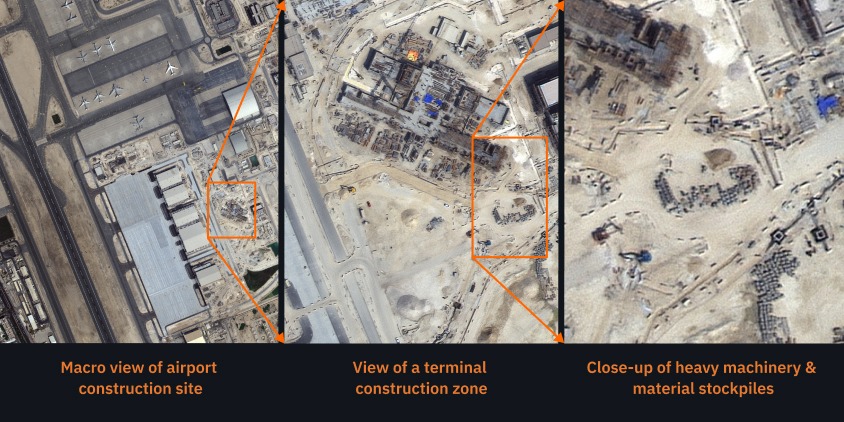
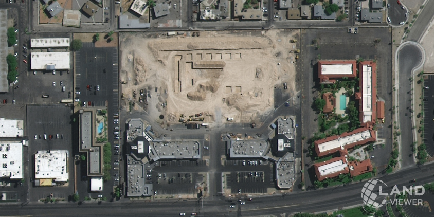
Moreover, high-resolution imagery allows you to zoom in on individual site assets. As shown below, 0.3 m resolution lets you transition seamlessly from a broad macro overview of the entire footprint down to active build zones, heavy machinery, and raw material stockpiles.
What changes at 30 centimeters per pixel
To get details you can actually use, you need commercial high-resolution or ultra-high-resolution imagery, which ranges from 1 m down to 30 centimeters per pixel. When a single pixel represents a space the size of an iPad, site monitoring in construction becomes much more reliable, and you can easily:
- differentiate between machinery types: whether it’s a crane, a dump truck, or an excavator;
- trace the exact perimeter of foundation walls, monitor roofing installation progress, and verify framing development;
- monitor the arrival and consumption of bulk raw materials (e.g., gravel piles or steel beams);
- oversee road grading, trenching boundaries, and the overall cleanliness of the site layout.
Moving to sub-meter imagery from satellites like BJ3N, SuperView NEO-1, and BlackSky Gen 3 takes the guesswork out of the process. It allows you to run remote monitoring for new construction and verify completed work directly from your desktop.
Benefits of satellite-based remote construction monitoring
Ground cameras and drones work well for quick security checks, but they cannot give you a complete view of massive, sprawling projects. By moving your perspective to orbit, you get an objective look at the entire site without any local restrictions.
Infinite scalability for mega-projects and infrastructure
Traditional site walks take days and put staff in hazardous areas. Drones are faster but are limited by short battery life and manual pilot hours. For massive infrastructure like pipelines or large communities, ground tools are simply too slow and expensive. Remote construction site monitoring solves this by capturing hundreds of square miles in a single pass. You get a uniform, complete view of your entire footprint without deploying hardware on the ground.
Completely remote and hassle-free
Setting up ground cameras is a logistical headache. They need power, internet, and poles. Drones require pilots on-site, battery charging, and airspace permits. Remote construction site monitoring is completely friction-free:
- You do not need to install hardware, charge batteries, or send people to the site.
- There are no local flight permits to secure or weather-enforced “no-fly” days to worry about.
- Out-of-town investors and project managers can check progress from any device, saving thousands on travel.
An unalterable archive to solve disputes
When subcontractors argue over deadlines or insurance claims arise, verbal updates are not enough. Unlike ground cameras — which can be damaged, blocked, or turned off — optical satellite imagery provides an independent, unalterable timeline of the build. You can even check historical images to see how the site looked months before work began, giving you a bulletproof paper trail for remote construction site monitoring.
Monitoring through clouds and darkness with SAR
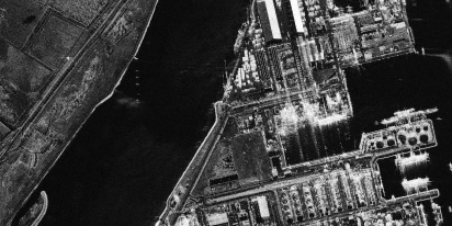
Drones and optical sensors need good weather and daylight for construction site monitoring, but synthetic aperture radar technology does not. SAR penetrates thick cloud cover, rain, and total darkness by bouncing radar waves off the ground. This technology ensures you can continue your remote construction site monitoring on a predictable schedule, no matter the weather or time of day.
How to use LandViewer for construction progress monitoring
Historically, getting high-quality satellite data for a construction project meant dealing with difficult coordinate systems and different suppliers. LandViewer combines high-resolution commercial data from multiple satellites and analytical tools in a single user-friendly web interface. It is a straightforward tool designed for everyday construction monitoring.
Here is a step-by-step guide to setting up automated remote monitoring for your next project.
Step 1: Find your site and filter the catalog
Enter your site address or coordinates to zoom in on your area. Then, use the filters to find the most suitable images:
- Date range. Align the imagery with your specific project milestones.
- Satellite provider and resolution. Choose high-resolution sensors, including SuperView, BlackSky, NewSat, and TripleSAT, to get the sub-meter detail needed for construction progress monitoring.
- Cloud cover percentage. Lower the cloudiness threshold to filter out foggy or overcast images.
- Historical archives. Pull satellite images, including NAIP aerial photos for US sites, to see how the ground looked in previous years.
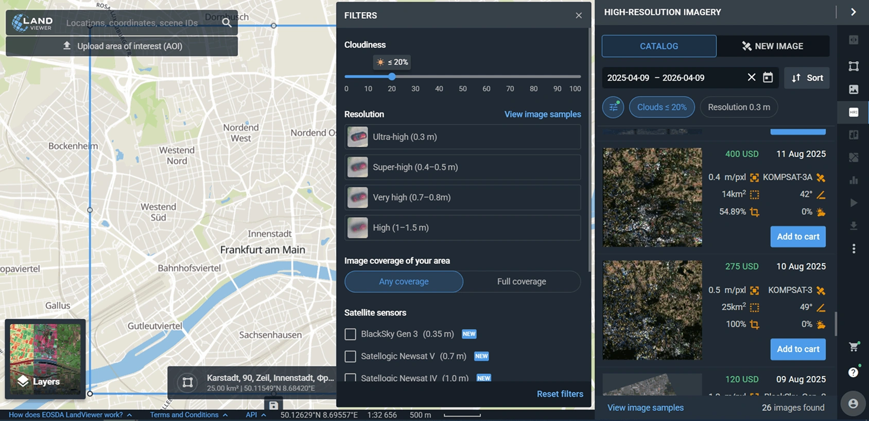
Once the parameters are set, review the instant previews and choose the best image for your needs.
Step 2: Download selected images
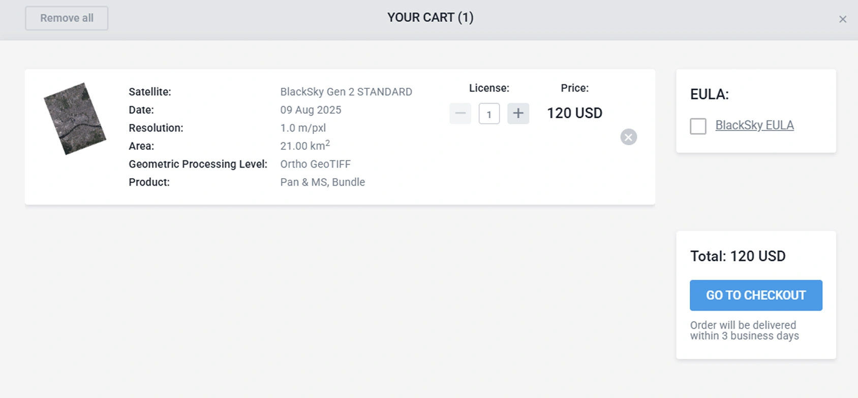
After picking the best high-resolution image of your construction site, add it to your cart and complete the checkout. You can then download the image and drop it into your project management software, attach it to insurance paperwork, or share it with stakeholders during construction progress monitoring.
Step 3: Request custom satellite tasking
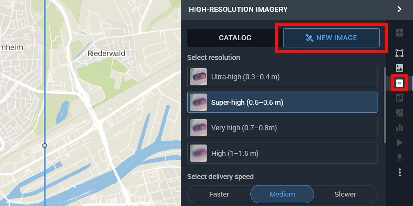
Sometimes, projects move too quickly for archived data. When you need an update on a certain day, with LandViewer, you can schedule a satellite imagery tasking of your exact coordinates, ensuring your construction progress monitoring never misses a milestone.
By integrating these three steps into your site monitoring routine, you replace fragmented, easily obstructed ground views with a continuous stream of truth. It is the most direct way to verify major milestones and share construction progress with stakeholders, no matter where they are located.
Can satellite monitoring completely replace drones and ground cameras?
How often can I get high-resolution satellite updates for my construction site?
What level of detail can I actually see on my construction site using satellite imagery?
Can satellites monitor my construction site through clouds and bad weather?
How does satellite monitoring help resolve construction disputes?
Choose up to 0.3 m high-resolution images from our catalog or request a satellite tasking.
More news
Satellite imagery tasking: How to order via the LandViewer platform
What if you could just order the satellite imagery you actually need? On-demand satellite tasking makes that possible — here's how it works and how to place your first order.
Digital surface model (DSM): How to map object heights
Need accurate elevation data for structures and land cover? See how digital surface models (DSMs) differ from bare-earth maps and learn how to get high-resolution stereo data for your area.
Optical satellite imagery: Getting insights from space
Ground inspections can be slow and expensive. Discover how commercial optical satellite imagery simplifies remote site monitoring and supports daily operational decisions.