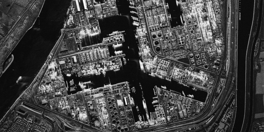
Optical satellite monitoring always depends on two things: clear skies and daylight. SAR (radar) imagery removes both requirements from the workflow, using active pulses to deliver consistent ground data 24/7 through cloud, rain, fog, or smoke blankets. Radar reads the Earth by surface roughness and material density, making it easy to identify structural changes, water boundaries, or vehicle movements.
Integrating SAR imagery into your analysis provides a reliable baseline for terrain tracking that remains unaffected even by disastrous environmental events. Here is a practical breakdown of how to interpret radar images, its main benefits, and how to source it effectively.
Key takeaways
- SAR imagery uses active radar pulses, allowing it to capture ground data 24/7 through clouds, rain, fog, or darkness.
- Unlike optical imagery, which reflects sunlight, SAR measures how surfaces reflect radar signals based on roughness, material, and moisture, making it useful for detecting structural changes, water boundaries, and soil conditions.
- Key benefits include all-weather imaging, day-and-night operation, immunity to sun glint, and the ability to penetrate vegetation and dry soil to varying degrees.
- Limitations of SAR imagery include interpretation complexity, grayscale-only output, and weak penetration into dense materials.
- Industries like maritime monitoring, defense, and disaster response rely on SAR imagery for continuous, weather-independent tracking of vessels, security threats, and emergencies.
- LandViewer offers both free Sentinel-1 imagery for regional monitoring and commercial SAR options with sub-meter resolution, daily updates, and historical archives for more precise local analysis.
What is SAR imagery?
SAR (synthetic aperture radar) images are remote sensing data products created from recorded radar signals. SAR data is produced by an active radar sensor mounted on a satellite or aircraft. Instead of relying on the sun’s reflection like optical satellite imagery, the radar sensor transmits its own microwave pulses toward the ground and measures the echoes that bounce back.
SAR systems operate across different microwave wavelengths — most commonly X-, C-, and L-band (about 3.1 cm, 5.6 cm, and 23 cm, respectively ). The choice of wavelength directly affects what SAR can detect: shorter wavelengths like X-band are sensitive to surface detail and small structures, while longer wavelengths like L-band penetrate deeper into vegetation and soil.
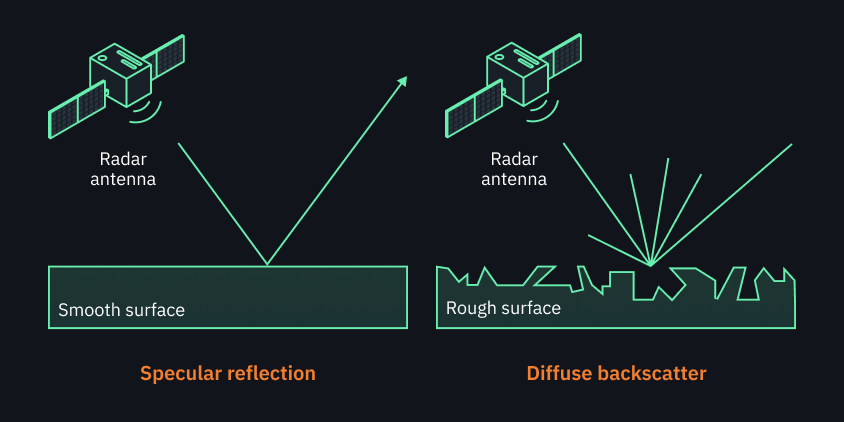
The strength and timing of returning echoes depend entirely on the physical characteristics of the target (roughness, shape, material, etc.). Smooth surfaces deflect the radar pulses away from the sensor, which creates dark areas on the final image. Conversely, rough or vertical structures scatter the energy back to the sensor, creating bright areas on the SAR satellite image.
Because microwaves don’t need sunlight and easily pass through water droplets, SAR imaging is completely unaffected by clouds, rain, or night-time darkness. So, radar imagery provides commercial users with a reliable, continuous source of visual intelligence under any environmental conditions.
SAR vs. optical imagery: Applications and advantages
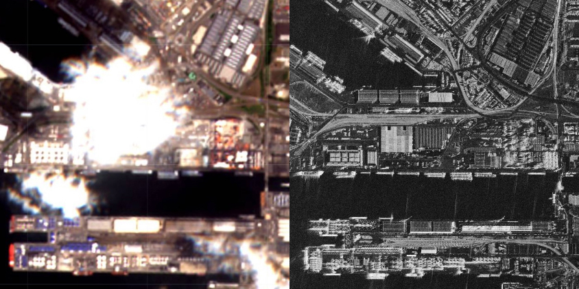
The main difference between SAR vs. optical imagery is how they interact with the Earth’s surface. Passive optical sensors act like standard cameras, collecting reflected sunlight to show colors and visible details, which requires clear skies and daytime. Active SAR sensors, conversely, emit their own microwave energy, allowing them to gather data 24/7 through clouds, rain, or smoke .
Unlike optical imagery, SAR is also sensitive to how the surface interacts with radar waves. For example, a wet field and a dry field may look similar in optical imagery if both are green, but SAR can show a clear difference because radar responds strongly to moisture.
This difference dictates their commercial use cases:
- In agriculture, for instance, optical satellite images help track crop health, while SAR images support measuring soil moisture and roughness underneath the leaves.
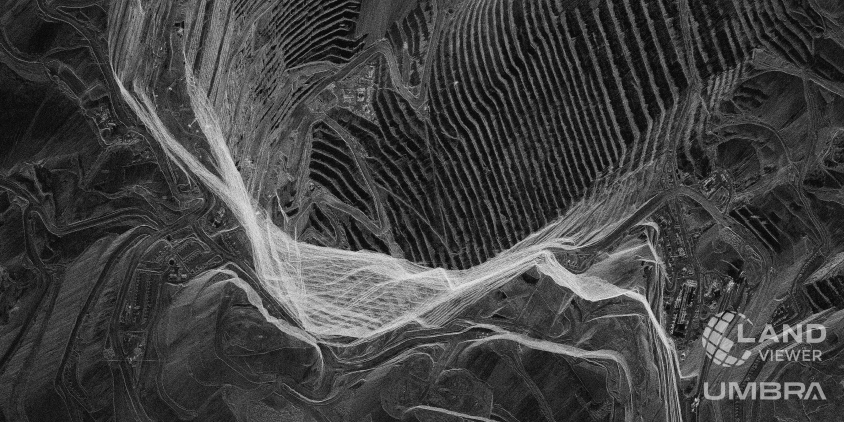
- Mining and pipeline monitoring use optical imagery for visual site inspections under clear skies, but switch to radar to track ground deformation or slope instability.
- During the disaster, optical imagery is frequently unsuitable because of storm clouds, whereas radar pierces cloud cover to outline affected areas instantly.
While optical satellite imagery remains the standard for intuitive visual identification, radar is a precise instrument for physical change detection and constant asset monitoring.
Benefits of SAR imagery for operational awareness
True situational awareness is impossible if your imagery stream stops every time the sky is cloudy. Radar monitoring runs continuously, regardless of bad weather, darkness, thick canopy cover, and sun glint.
All-weather imaging
On average, clouds or darkness cover about two-thirds of the planet at any given momentmoment . Fortunately, synthetic aperture radar imaging captures ground conditions through clouds, thick fog, and smoke blankets. This is especially important in disaster response, when physical access is difficult, and smoke or cloud cover renders optical images useless. In such moments, SAR satellite images become a lifeline for planning evacuations and delivering aid.
Day and night operation
Because radar satellites use their own microwave signals instead of relying on sunlight, they capture images at any hour. Night-time SAR imaging means monitoring never pauses, ensuring no gaps and consistent imagery over time. Steady data stream makes SAR a reliable tool for tracking rapid ground changes, managing ongoing operations, and keeping a constant eye on high-security sites.
Material sensitivity
SAR signals respond strongly to surface moisture and material type — wet soil, flooded areas, and dense vegetation typically return more energy back to the sensor than dry or frozen ground. Metal structures and buildings reflect radar with particularly high intensity due to their geometry, making them easy to detect and monitor. In practice, this means SAR imagery can tell you whether a field is waterlogged before you send in equipment, confirm whether a building has been constructed, or identify which areas are still flooded after a storm.
Sun glint
Sun glint is a common problem in optical images — sunlight bouncing off water or metal surfaces at some angle can create bright, featureless patches that make images unusable. Because SAR relies on its own transmitted pulses rather than reflected sunlight, it is completely immune to this effect.
Penetration of foliage and soil
SAR signals can penetrate vegetation canopies and dry soil to varying degrees depending on wavelength and surface conditions. Longer wavelengths such as L-band penetrate deeper, reaching the ground beneath forest cover or detecting subsurface soil layers. Dry soil allows significantly more penetration than wet soil. This is why SAR imagery can be useful for mapping terrain under vegetation, detecting buried infrastructure, or monitoring subsurface soil conditions.
Limitations of SAR imagery and how to handle them
SAR imagery is powerful, but like any technology, it has constraints that affect how and when it can be used. Let’s take a look at these constraints so that you can set realistic expectations for your monitoring projects.
Interpretation complexity
Accurate SAR image interpretation demands specialist knowledge and dedicated software. Raw SAR data contains speckle noise and surface interaction patterns that are difficult to read without training. This is one reason why most commercial users work with pre-processed data products rather than interpreting radar images directly.
Beyond noise, images by SAR don’t represent scenes visually the way optical imagery does. A skilled analyst can identify that a feature is man-made, but distinguishing a warehouse from a factory, for example, typically requires contextual knowledge or additional imagery sources.
Sensitivity to surface properties
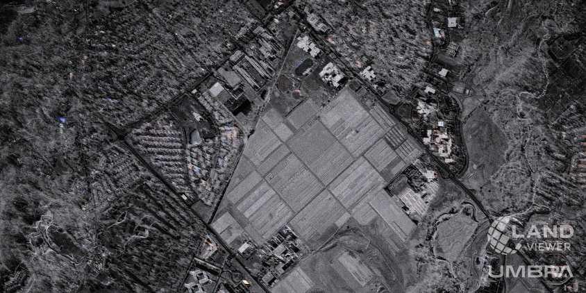
SAR is sensitive to surface moisture, roughness, and material. Even minor variations in ground conditions produce visible differences in the image — which can be useful, but also adds complexity. On farmland or at urban edges, brightness patterns often reflect physical surface properties rather than clear boundaries, making it harder to tell features apart without additional context.
Color
SAR images are grayscale because they record radar backscatter, not visible light. That means SAR cannot directly show true colors of roads, vegetation, water, buildings, or soil the way an optical satellite image can. False-color composites or extra optical layers might be needed to simplify radar imagery interpretation.
Weak penetration into dense materials
SAR passes through clouds easily, and longer wavelengths can partially penetrate vegetation. But denser materials — rock, concrete, wet soil — mostly reflect the signal at the surface rather than letting it through. The drier and less dense a material is, the deeper SAR can see into it.
These limitations don’t make SAR imaging any less impressive; they just mean you need the right approach to use it well. At the end of the day, no other monitoring technology gives you the same reliable, all-weather imagery.
How to analyze SAR imagery
While аdvanced SAR analysis requires specialized software, anyone can learn to read the basic layout of a radar image. Instead of looking at a SAR image like a standard photograph, you need to focus on shapes and textures to unlock data for your projects.
Here are the main tips for understanding synthetic aperture radar images:
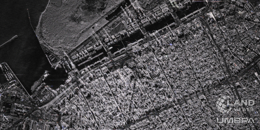
- Brightness and backscatter. Think of SAR image brightness simply as a map of radar energy received back. Bright image areas mean the satellite received a strong return signal from rough or well-structured objects like buildings, while dark areas mean very little energy made it back to the sensor from smooth features like a water body.
- Surface roughness. Surface roughness is a major factor behind SAR image brightness. Rough surfaces — like plowed fields, rocky terrain, or construction sites — scatter the radar signal in many directions, so more energy returns to the sensor. Smooth surfaces like paved roads or calm water tend to reflect the signal away, which is why they usually appear dark in radar images.
- Landscape features. You can use brightness-darkness patterns to distinguish different landscapes. Water is often smooth, so it usually looks dark in SAR images. Plants create a medium-gray to bright, textured look depending on density, moisture, and canopy structure. Cities and industrial areas often look bright because buildings create strong double-bounce and corner reflections that return more signal to the sensor.
These basics are enough to let you map flood zones, track crop growth, or check supply chains right through the clouds. Once you learn how your assets look on a radar image, you can easily use this imagery to back up your day-to-day business decisions.
How different industries use synthetic aperture radar data
Commercial and defense operations cannot pause just because a storm rolled in or the sun went down. SAR ensures that imagery flows without gaps, which is crucial when you need to check the state of a flooded field, detect a sudden oil spill, or track border activities. Let’s look at how different sectors use radar insights in the real world.
Agriculture and forestry
SAR imagery supports crop type mapping, soil moisture assessment, and field-level monitoring throughout the growing season. Agronomists use it to track plowing, tillage, and harvest activity across large farmland areas. It also feeds into yield estimates and resource planning for agricultural operations. In forestry, SAR datasets help map biomass, track canopy changes, and monitor deforestation or regrowth over time.
Maritime monitoring
Open water gives a flat, predictable signal, so anything unusual — a ship, a slick, debris — stands out fast. This makes SAR imagery a core tool for maritime surveillance, tracking vessels and flagging illegal activity like unauthorized fishing or ship-to-ship transfers. Since it works in any weather, at any hour, it fills gaps that other monitoring methods can’t cover.
Defence and intelligence
SAR provides persistent surveillance over military sites, harbors, and vehicle movement, useful for both routine monitoring and active threat detection. Since it can easily detect vessels that turn off their tracking systems, it’s a core tool for maritime and border security. It takes away the element of surprise because any critical shift in infrastructure or activity stands out on the SAR image instantly.
Disaster monitoring and emergency response
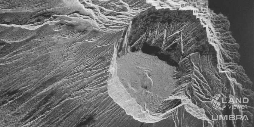
When a disaster strikes, rescue teams cannot afford to wait for a storm to clear or the sun to come up. Radar imagery cuts straight through heavy wildfire smoke, volcanic ash, and thick cloud cover to show affected areas and particular damage. Emergency services use near-real-time radar images to map out safe rescue routes and deploy teams to the hardest-hit areas without losing critical hours.
Finding the right SAR imagery for your project
Depending on your project’s budget and technical requirements, LandViewer gives you two ways to get SAR images. The first way is using free Sentinel-1 imagery with regular, wide-scale updates for tracking large regional events like river floods, land subsidence, or seasonal vegetation changes. However, when your analysis demands sharp object recognition, your best move is to buy SAR imagery from commercial fleets like ICEYE, Capella, or Umbra. Working with multiple satellite data providers inside one platform gives you a few advantages:
- Higher image availability. Switching between providers drastically increases your chances of getting a clean, high-quality image of your exact coordinates.
- Sub-meter precision. You get access to imagery with up to 0.25-meter resolution, where it is easy to identify individual vehicles or small infrastructure objects.
- Daily updates. You can view fresh images every 24 hours to monitor fast-moving events in near-real-time.
- Deep archives and tasking. You can either pull historical satellite images dating back to 2020 or order custom, on-demand captures for upcoming dates.
Instead of analyzing radar images in isolation, you can merge them with LandViewer’s optical imagery to verify your findings. For example, in environmental monitoring, radar maps the physical geometry and water content of the landscape — even catching water pooling underneath thick leaves — while optical bands handle the spectral classification of land cover types or even plant varieties. Combining these two imagery sources gives you the best of both worlds — physical ground structure and spectral details. In the end, you get a much more accurate view, allowing you to confidently monitor your project site through any season and any weather.
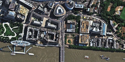
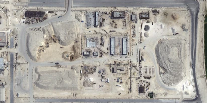
Provide your target coordinates, area size and specific requirements to receive radar data.
More news
Satellite imagery tasking: How to order via the LandViewer platform
What if you could just order the satellite imagery you actually need? On-demand satellite tasking makes that possible — here's how it works and how to place your first order.
Digital surface model (DSM): How to map object heights
Need accurate elevation data for structures and land cover? See how digital surface models (DSMs) differ from bare-earth maps and learn how to get high-resolution stereo data for your area.
Digital elevation model (DEM): Guide to terrain mapping
Planning earthworks, drainage, or tower placement? See how digital elevation models reveal true ground contours and how to source site-specific DEM grids without overpaying.