An outdated view, a bad angle, clouds covering the one spot you needed clear — these are the usual problems with archive imagery. Satellite tasking works around them: you request new imagery of your exact area, captured within the dates you choose, instead of searching through what’s already on file. The LandViewer satellite imagery platform lets you set this up directly, without going through a drawn-out quote process. Our step-by-step satellite tasking guide walks through how it works, when it makes more sense than an archive, what affects the price, and how to place your first order.
Key takeaways
- Satellite tasking means ordering brand-new imagery of a chosen area, within a set time window and with your own specs.
- Choose on-demand tasking over archive imagery when you need recent, precise, or repeated coverage.
- Tasking price and turnaround depend on resolution, sensor, collection window, cloud cover tolerance, viewing angle, and priority level.
- LandViewer simplifies on-demand satellite tasking into a few-click workflow backed by access to top constellations and expert GIS checks.
What is satellite tasking?
Satellite tasking is an on-demand ordering of new imagery for your project. You select an area of interest, choose a time window, and set requirements such as spatial resolution, cloud cover, or viewing angle. The operator schedules the satellite pass and delivers the imagery.
Only a few decades ago, satellite tasking was mostly limited to governments and defense organizations. Requests were often arranged through direct contacts, with long planning times and little flexibility.
The 1999 launch of the IKONOS satellite made on-demand high-resolution imagery commercially available for the first time . After that, more private satellites went up, prices dropped, and ordering became simple. Now most of it runs through user-friendly platforms, so an order can take minutes and delivery just a few days.
Satellite tasking vs. archive: When to order a new capture
Deciding whether to buy archive imagery or request on-demand satellite imaging comes down to project priorities: historical context versus real-time overview. Digital imagery archives are a good starting point. They let teams study land changes over several years, establish baseline environmental conditions, and run initial site surveys without spending much budget.
However, archives are inherently limited by past capture choices. Historical satellite imagery was taken at specific times, from fixed camera angles, and under whatever weather conditions happened to exist that day. When an operation depends on precise timing, clear visibility, or targeted coverage, relying on pre-existing data is risky.
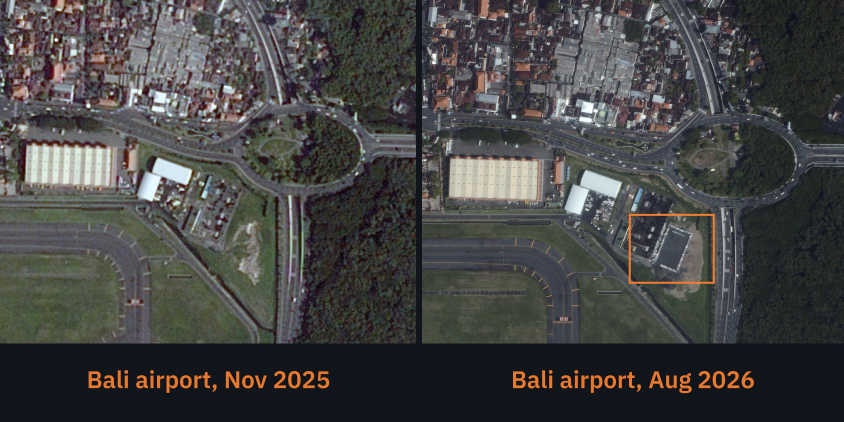
Here is a quick summary of key differences between on-demand satellite tasking services and imagery archives to help you choose the right option for your project.
| Parameters | Satellite tasking | Archive |
|---|---|---|
| Delivery speed | 3–14 days (may be less with rush options) | Up to 24 hours |
| Starting cost (AOI-based) | $250 (depending on specs and priority) | Around $100 |
| Customization | Custom AOI, resolution, angles, cloud limits | Pre-set angles, bands, bounds |
| Cloud cover | Guaranteed max threshold (e.g., <15%) | As-is |
| Uses | Near-real-time progress monitoring, emergency response | Historical change analysis, baseline mapping |
Satellite tasking, based on your exact project requirements, eliminates the need to fit your work around older archive scenes. Ordering a new satellite pass is necessary when:
- You need imagery from the last 24 to 72 hours, and standard platform catalogs have no recent coverage.
- Your project site crosses standard imagery tile borders, so you define an on-demand tasking boundary on the platform and pay only for your target area.
- You need to track ongoing changes, such as construction work or land movement, on a regular weekly or monthly schedule.
- Cloud cover is frequent in your target area, so you require the operator to re-attempt passes until they capture clear imagery.
Ultimately, archives work best for looking backward, while satellite tasking is perfect for monitoring active, fast-changing environments and operations.
Which parameters define satellite tasking suitability and cost?
When you set up a satellite tasking order on the platform, every technical parameter you choose affects the total price and the final imagery quality. Fine-tuning settings like imagery resolution, delivery speed, and cloud cover thresholds lets you get the exact data you need without overspending.
Spatial resolution
Spatial resolution, described by ground sample distance (GSD), shows how much ground area a single pixel covers :
- Sub-meter high resolution (0.3–0.8 m). From sharp enough to make out individual cars, structural details, and specific equipment, to high-detail coverage for tracking infrastructure and project sites. High-resolution imagery with sub-meter detail is the right choice when precision is critical.
- High resolution (1–1.5 m). A more cost-effective satellite tasking option for wider-area mapping, environmental monitoring, or agricultural surveys across larger regions, where general patterns matter more than details.
Type of sensor: Optical or SAR
Ideal satellite tasking conditions rarely exist on demand; you are almost always fighting clouds, darkness, or strict detail requirements. Choose a sensor based on where your target is and what conditions you’re actually working with:
- Optical sensors use natural light to produce imagery, similar to how a camera works. High-resolution optical satellite tasking imagery (30–50 cm per pixel) is ideal for identifying specific objects, inspecting structures, or reading fine detail on the ground. However, optical satellite imagery depends on daylight and clear weather. Cloud cover or darkness means no usable imagery.
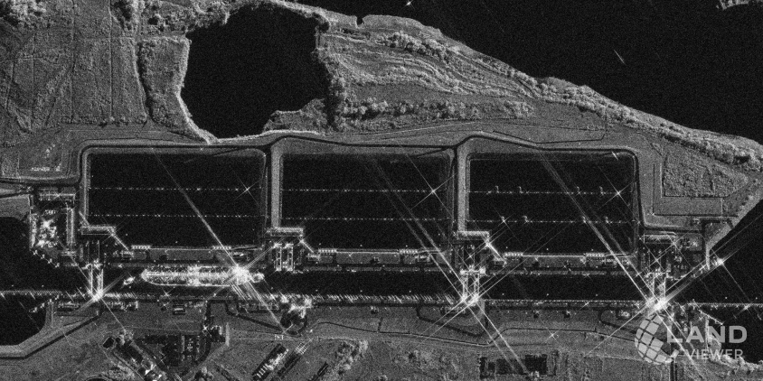
- SAR (synthetic aperture radar) sensors don’t rely on light at all. They send radar waves toward the ground and read the signals that bounce back, so they work regardless of cloud cover, time of day, or weather conditions. Before you buy SAR imagery, you should know that it isn’t meant to replace optical: radar satellite tasking is a specialized solution for situations where consistent coverage matters more than visual detail.
Revisit rate and collection window
Revisit rate and collection window are the two levers that control how fast you get satellite tasking results and how much flexibility you’re giving to work around bad weather:
- Revisit rate. The more satellites in a constellation, the more often they can pass over your target area and the faster turnaround on your order.
- Collection window. The date range you grant for satellite tasking directly affects success rate and price. Stretch it out, and you’re far more likely to receive clear, cloud-free on-demand imagery. Squeeze it tight, and you’ll need to pay for priority scheduling to guarantee results in time.
Cloud cover tolerance
Clouds are the biggest wild card in optical satellite tasking. When you place your order on the platform, you choose how much cloud cover you’re willing to accept, usually somewhere between 10% and 20%. A stricter limit means cleaner, clearer imagery of your site, but it may take the satellite a couple of extra tries if the local weather doesn’t play along.
Off-nadir (incidence) angle
This describes how tilted the satellite’s view is compared to looking straight down at your target:
- Near-nadir (0°–20°). A straight-on, top-down view with almost no tilt or distortion.
- Off-nadir (20°–30+°). Lets the satellite capture imagery faster and more often, since it doesn’t have to be directly overhead. The trade-off is a bit of visible lean on tall buildings at steeper angles.
Priority level and turnaround time
Priority level determines how your order is queued relative to others. Under standard priority, delivery typically takes 7 to 14 days. Rush priority moves your request ahead in the scheduling queue, which can shorten delivery to 24 to 72 hours, provided weather conditions at the target site cooperate. The faster turnaround reflects the added cost of securing priority access to satellite passes, not just the on-demand imagery itself.
Pick your collection window based on how urgent your project is. If your timeline is flexible, a 3 to 6-week window gives our team and vendor network plenty of chances to capture clear, cloud-free imagery. If your deadline is tight, a 1 to 2-week window will put satellite tasking speed first.
How to order satellite tasking in LandViewer
Satellite tasking workflow used to force buyers through indirect sales channels and quote negotiations. The LandViewer platform lets you set it all up yourself online, while our team handles the technical checks in the background to make sure you receive the best possible final imagery. Here’s how to task a satellite in LandViewer.
Step 1. Specify your target area.
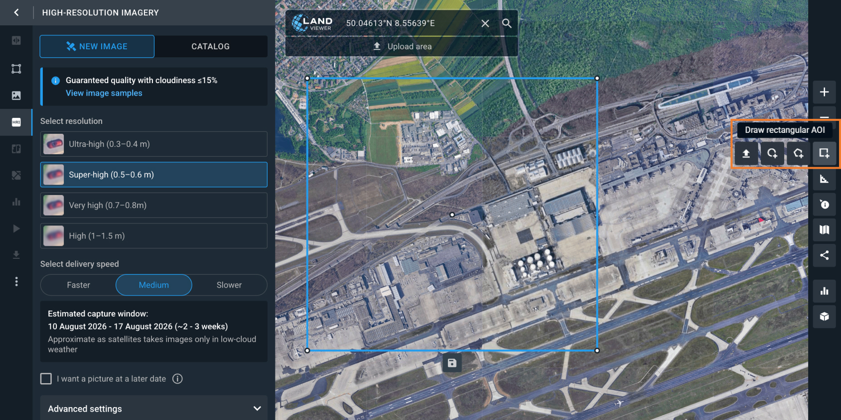
Start by marking your target location on the platform map. Draw your area directly with the polygon tool, or, if you’ve already got the coordinates mapped out elsewhere, upload a KML, Shapefile, or GeoJSON file instead.
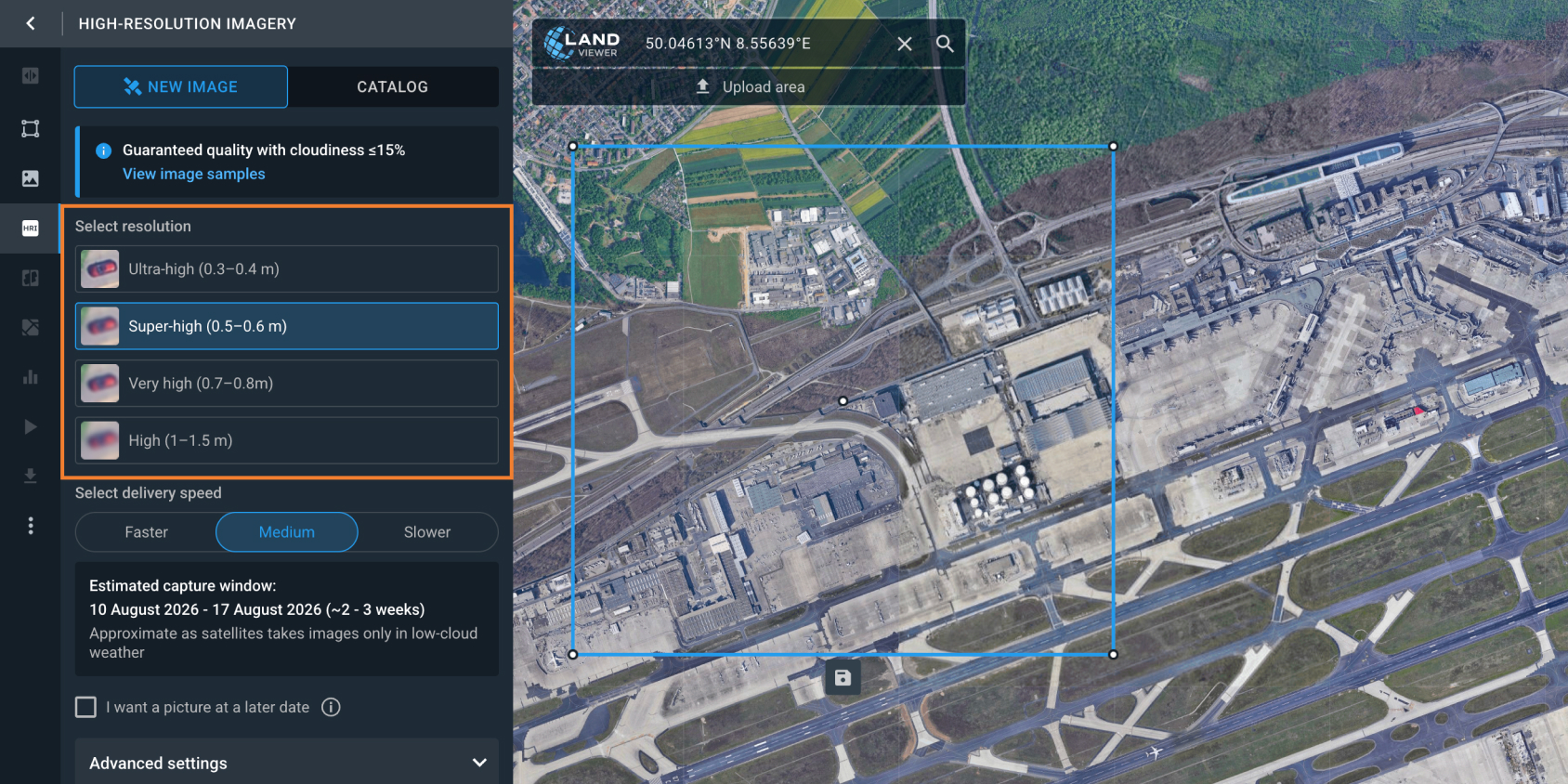
Step 2. Select the resolution that fits your needs.
Next, decide which level of detail you actually need:
- Ultra-high resolution (30–40 cm). Exceptional clarity from BJ3N, KOMPSAT 3-A, SuperView NEO-1, and Black Sky Gen 3 for spotting individual objects or structural details.
- Super-high resolution (40–50 cm). Ideal for remote construction site monitoring, tracking facility updates, and civil infrastructure planning.
- Very high resolution (70 –80 cm). Solid choice for broad site planning, forestry, and urban surveys.
- High resolution (1–1.5 m). Budget-friendly option for mapping expansive land areas where object-level detail is unnecessary.
Step 3. Select the desired delivery speed.
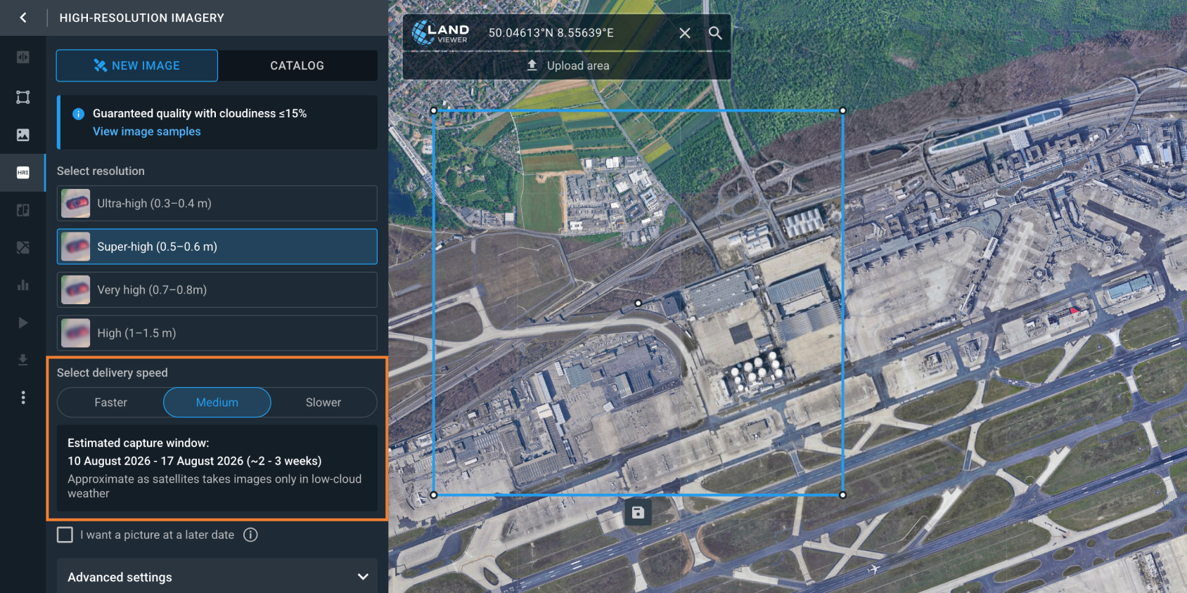
Based on your project timeframe, choose from the following platform’s options:
- Faster (<1–2 weeks ). Best for urgent monitoring or time-sensitive projects.
- Medium (2–3 weeks ). The sweet spot between getting your on-demand imagery quickly and making sure the capture succeeds.
- Slower (3–6 weeks). Leaves more room for the satellite to wait for clear conditions.
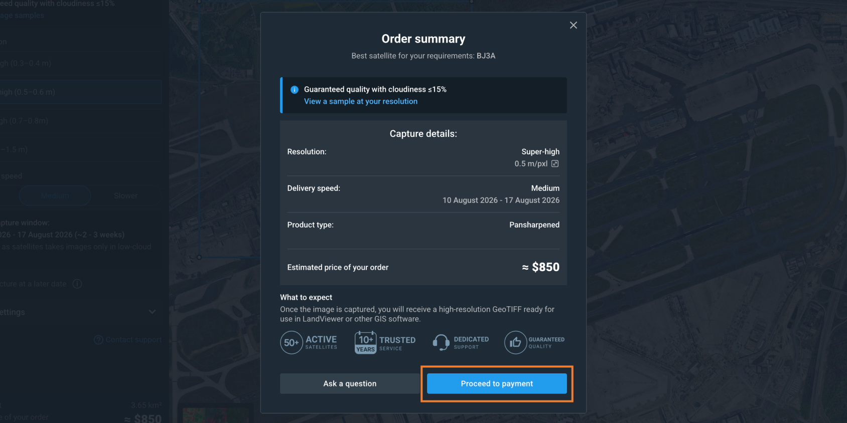
Step 4: Your request’s feasibility is verified and the order is fulfilled.
Behind the scenes, the LandViewer platform connects you to a wide network of providers: BlackSky, Satellogic, SIIS, SpaceWill, and others, so you’re not locked into a single satellite’s schedule or capabilities. Once you place your order, our GIS team checks feasibility — orbital paths, weather patterns near your site, and provider availability — to match your request to the right satellite and fulfill it exactly as specified.
You can also mix sensor types depending on the job: optical for visual detail, SAR when clouds or darkness get in the way, or stereo imagery for building digital elevation models. And every order comes with a cloud cover guarantee of 15% or less, so you know the imagery you get will actually be usable. It’s the difference between just tasking a satellite and knowing your data will hold up when you need it.
How much does high-resolution satellite tasking cost?
How fast can a satellite tasking order be fulfilled?
What happens if there are clouds over my area of interest during collection?
What is the highest optical resolution available for on-demand tasking?
What is the difference between single-image tasking and satellite monitoring?
Does LandViewer support regular, recurring monitoring through satellite tasking?
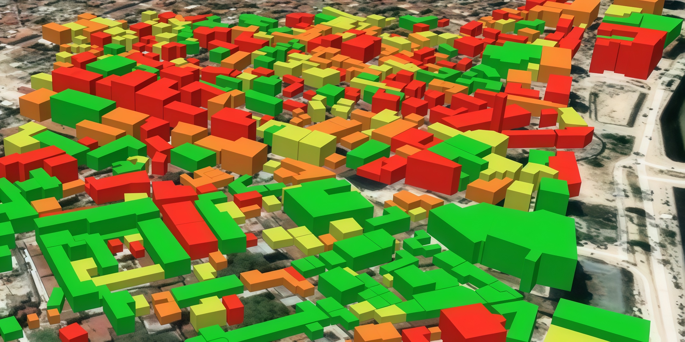
Choose up to 0.3 m high-resolution images from our catalog or request a satellite tasking.
More news
Digital elevation model (DEM): Guide to terrain mapping
Planning earthworks, drainage, or tower placement? See how digital elevation models reveal true ground contours and how to source site-specific DEM grids without overpaying.
Construction site monitoring: The guide to remote progress tracking with satellite images
From cameras and drones to satellites: a practical look at how construction site monitoring works, where each tool shines, and what a remote, orbital view actually adds.
SAR imagery: How synthetic aperture radar technology works
Want to monitor assets without weather delays? Learn how SAR imagery captures soil moisture, floods, and structural shifts through clouds and smoke for your monitoring projects.