Google Earth (GE) is excellent for casual exploration and finding local landmarks. However, when a business project needs technical precision, a lack of recent imagery or low resolution becomes a major roadblock. Using a professional Google Earth alternative allows experts to bypass these limitations and make better decisions with recent high-resolution data.
The difference between a casual map and a professional satellite data platform lies in frequency and detail. Understanding what is a better alternative than Google Earth for your business helps you establish a stable monitoring system that keeps you truly up to date.
Why look for an alternative to Google Earth?
While Google Earth is a household name, it often falls short when you need up-to-date high-resolution imagery. Here are the main reasons to look for Google Earth alternatives:
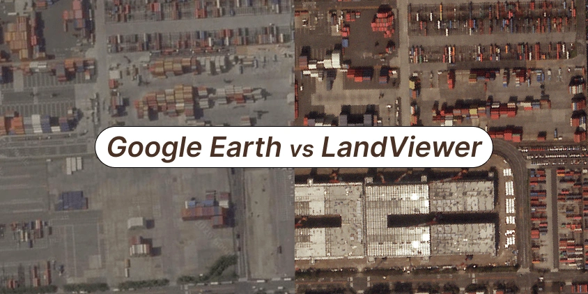
- Inconsistent resolution. Better, higher-quality views are usually reserved for big cities . Outside these zones, Google Earth resolution drops to approximately 15 meters, which is often too blurry for professional monitoring.
- Outdated images. GE rarely updates its archive. You might be looking at your property as it appeared years ago, rather than just weeks or days ago, as with the alternative satellite images provider.
- Atmospheric interference. GE static maps may be stuck with a shot taken on a cloudy or hazy day, so it’s impossible to see specific land features.
- Processing artifacts. Google compresses images, which leads to a loss of sharpness compared to alternative raw professional data.
- Privacy and security concerns. Certain government facilities, military bases, and sometimes even residential areas may be intentionally blurred or downgraded in resolution.
LandViewer acts as a professional alternative by granting access to diverse satellite sources with a better, clearer view than Google Earth.
LandViewer vs. Google Earth: The shift to professional data
Both Google Earth and LandViewer provide a bird’s-eye view of our planet, accessible from any device with an internet connection. On the surface, these alternatives might look similar, but they are designed with different end-users in mind.
Google Earth functions primarily as a geobrowser — a tool for casual use. While it might be better for a broad overview, LandViewer is built as an alternative professional satellite data platform where precision and frequency are the priority.
One of the most significant differences between these alternatives is their coverage and updates. LandViewer’s better reach is powered by a network of over 20 high-resolution satellites, ensuring that even remote or rural areas are well documented and updated regularly.
Is Google Earth accurate?
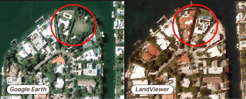
GE is accurate in terms of relative location — streets, buildings, and landmarks are where they should be . However, Google Earth lacks temporal accuracy, offering images months or years old.
Professionals in real estate, agriculture, or remote construction site monitoring need not just static pictures, but a reliable alternative data feed to better track changes on the ground. Unlike GE maps with mosaics several years old, LandViewer offers a deep historical archive of high-resolution images with a much smaller time gap between snapshots.
Furthermore, LandViewer features alternatives allowing to see beyond the visible spectrum — multispectral and SAR (radar) images. It also includes built-in analytical tools, essential for research or commercial projects.
When does LandViewer beat Google Earth?
A few years of delay or a blurry zoom in apps like Google Earth might not matter for casual browsing, but become a blocker for business and research. Here’s where LandViewer stands out as the professional alternative for Google Earth.
If you need to look back in time
GE is a great starting point for viewing an area. However, you might find a clear shot, followed by a long gap where nothing was recorded. This inconsistency is one of the main Google Earth problems for people trying to see their area at a specific point in the past.
Consider the aspects where a better alternative is required to meet professional standards:
- Coverage. LandViewer is a reliable alternative to Google Earth because it maintains a steady, multi-year archive for almost any location, not just big cities.
- Imagery detail. Google Earth resolution can be disappointingly low, particularly in older shots. LandViewer provides better data consistently across its entire archive, with pro satellites like SuperView NEO-1 and BJ3N capturing data at a staggering 0.3m.
- Updates. Free maps are updated rarely, when they happen to get a clear, cheap shot. LandViewer is better than Google Earth for monitoring because it updates views of practically any area daily.
This makes LandViewer a better way to watch a new building go up or check for illegal forest clearing. If you need a timeline without missing chapters, it is the best alternative for Google Earth.
If you need to see the current state
A common mistake is thinking that satellite maps are a live video feed of our planet. In reality, neither Google Earth nor LandViewer provides a live stream. However, the difference in timing is huge.
While common geobrowsers show static pictures that are months or even years old, LandViewer offers a better alternative to access near real-time data to easily track a project’s progress. This is possible because we use advanced satellite constellations, including SuperView, BlackSky, and NewSat, that revisit the same area multiple times every single day.
If you need regular and predictable updates
Rural or industrial sites are neglected for years in free mapping apps, which is why professionals look for Google Earth competitors that offer more frequent coverage. When you are working on a tight deadline, you quickly realize what’s better than Google Earth for getting a truly fresh look at your site: a platform that operates on your schedule. With LandViewer’s alternative, you gain access to satellites like NewSat with up to 4 revisits daily or BlackSky Gen 3 with up to 15 revisits daily.
Use LandViewer’s tasking service to send a satellite to your specific area of interest right when you need it or set up regular monitoring to track changes over time. We offer three alternative timings so you can choose a better option based on how fast you need the data and your budget.
If the free tools don’t have what you need, switching to professional Google Earth alternatives ensures you aren’t left waiting for an update that might never come. Here is a quick look at the main technical differences between the alternatives.
| Google Earth | LandViewer | |
|---|---|---|
| Freshness of data | Outdated mosaics | Daily updates and on-demand tasking |
| Historical data | Rare, random snapshots | Rich, structured multi-source archive |
| Monitoring frequency | Undefined | Regular revisits |
| Control over data | No | Choosing between alternative satellites, resolutions, and dates |
| Built-in analytics | No | Spectral indices, change detection, and more |
Why choose LandViewer as an alternative to Google Earth
Choosing the right tool depends entirely on your objectives. GE is better if you want to view locations visually for casual exploration. But if your work requires you to access recent satellite images, analyze changes over time, or work with reliable historical data, you need a better alternative.
LandViewer is one of the best alternatives to Google Earth because it fills the gap between simple visualization and professional monitoring. It is designed for those who need more control, fresher data, and built-in analytics. When the stakes are high, having a better source of information is a necessity. So, LandViewer becomes the go-to alternative for researchers and business owners alike.
About the author:
Kateryna Sergieieva has a Ph.D. in information technologies and 15 years of experience in remote sensing. She is a Senior Scientist at EOSDA responsible for developing technologies for satellite monitoring and surface feature change detection. Kateryna is an author of over 60 scientific publications.

More news
Digital elevation model (DEM): Guide to terrain mapping
Planning earthworks, drainage, or tower placement? See how digital elevation models reveal true ground contours and how to source site-specific DEM grids without overpaying.
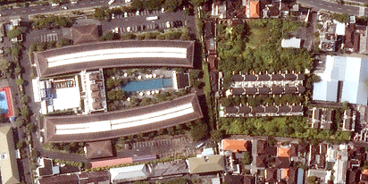
How to get a satellite view of my property?
Businesses need independent visual data to protect their investments. In LandViewer, you choose the date and source to get the satellite property photos for logging site damage or build readiness.
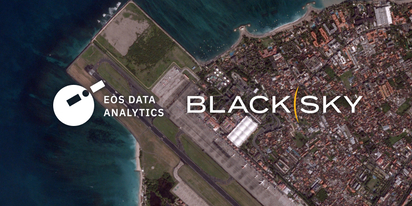
LandViewer welcomes BlackSky Gen-3 high-resolution imagery
LandViewer has expanded its high-resolution catalogue with BlackSky Gen-3, offering 0.3 m imagery, up to 15 daily revisits, and AI-powered analytics for detailed analysis and daily site monitoring.