Satellite API — Fast and Easy Access to Raw and Processed Data
Get direct access to satellite imagery and geospatial analytics through our high-performance API. Stream real-time data into your platform effortlessly. Backed by years of hands-on experience in satellite-powered solutions, we build scalable, ready-to-integrate tools for a wide range of industries, including:
- Software Development & Data Science
- GIS & Remote Sensing
- Environmental Monitoring
- Urban Planning
- Agriculture & Farm Management
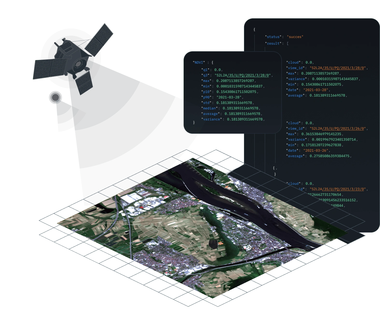
How Satellite Data Delivery via API Works
An API (Application Programming Interface) is kind of bridge that links different software systems, allowing seamless information exchange through code. Forget downloading and manual processing — our satellite image API brings data directly to your tools and workflows. Here's what you get:
- regularly updated high-resolution satellite images
- raw spectral bands and processed imagery with any of 20+ available indices or band combinations applied
- raster images in JPEG, PNG, or GeoTIFF formats

Satellite Data Interface Integration and Real-World Applications
Use real-time satellite imagery to build powerful, tailored solutions. Develop new platforms with our scalable, high-precision data or seamlessly integrate it into your existing tools.
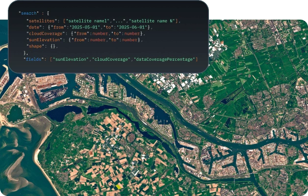
Geospatial Data API
- Retrieve space-derived insights at any scale — from a single point to vast territories
- Download imagery from 9+ trusted satellites
- Access 20+ preset and custom band combinations for natural disaster, urban, or environmental analysis
- Improve accuracy with advanced cloud-masking technology
- Integrate elevation measurements and terrain maps into your GIS applications.
Perfect fit for: GIS mapping platforms, urban planning and land-use analysis solutions
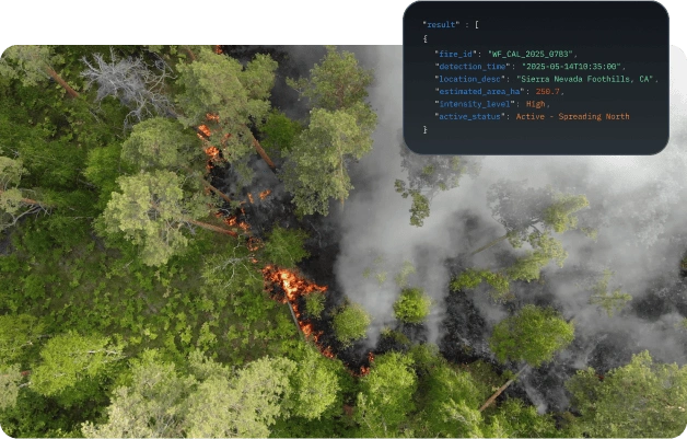
Environmental and Natural Disaster Monitoring API
- View real-time satellite map API insights on disaster activity worldwide
- Detect and monitor earthquakes, floods, wildfires, droughts, coastal erosion, and changes in waterbodies
- Analyze past events to identify patterns and improve disaster management strategies
- Support response teams, validate insurance claims, back scientific disaster studies and other use cases through spatial data API.
Perfect fit for: emergency service providers, insurance platforms, researchers, government agencies
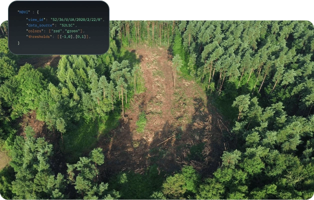
EU Deforestation Regulation (EUDR) API
- Monitor deforestation across palm oil, soy, and cattle supply chains
- Achieve transparency through near real-time monitoring of deforestation and forest degradation
- Track forest restoration and establishment progress with the tree planting API analytics to meet legal reforestation and afforestation targets
- Generate detailed compliance reports for regulatory audits
- Conduct long-term analysis with instant access to historical and real-time satellite API forest change data.
Perfect fit for: EUDR compliance teams, sustainable agribusinesses, environmental projects
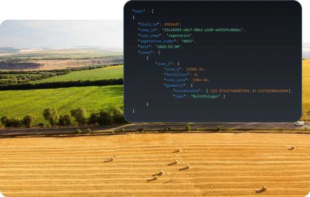
Farm Data API
- Analyze soil moisture trends with satellite data available from 2016 onward
- Monitor crop health using NDVI, RECl, MSAVI, NDMI, and other vegetation indices
- Power your VRA mapping, biomass measurement, and disease risk assessment with EOSDA Crop Monitoring insights.
Perfect fit for: agritech platforms and precision farming apps
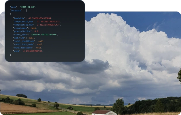
Weather Data API
- Retrieve up to 10 key parameters, including temperature, wind, and humidity, through a current weather data API
- Get reliable 14-day hourly forecasts for your location
- Build trend models and assess natural catastrophe risks with API access to historical weather records since 1979.
Perfect fit for: tech solutions in climate research, agriculture risk modeling, and insurance
Start in Just a Few Steps
Sign up and get your personal access key.
Seamlessly integrate insights into your app or analytics pipeline.
Access high-quality satellite images or other information upon your request in real time.

Why Choose Our API Satellite Images?
Get satellite images from any location across the globe.
Access NDVI, EVI, RGB, SWIR, and other key spectral bands.
Stay ahead with up-to-date imagery delivered every day.
Speed up integration through our user-friendly REST application programming interface.
Get only the data that matters — served when and how you need it.
Data Sources Behind Our Satellite Imagery API
EOSDA has been in the satellite analytics game long enough to know what works. With input from over 16+ trusted sources, we ensure the information you receive is complete, validated, and tailored to your needs — not just collected for the sake of it.


Landsat 9
Archive: since 2021

