KOMPSAT-3A
The imagery, acquired by KOMPSAT 3/3A can be obtained from SIIS (SI Imaging Services), which is an exclusive representative of the KOMPSAT constellation. Each product is provided as a specific set of data: pan + four multispectral or as four pansharpened bands. Image data processing levels:
- Level 1R (Corrected for radiometric and sensor distortions)
- Level 1O (Ortho-ready)
- Level 1G (Geometric distortion correction by using SRTM DEM)
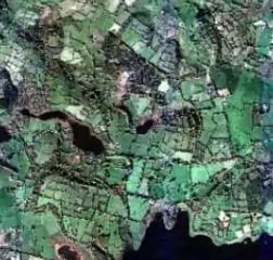
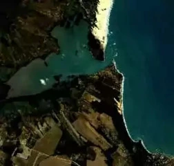
KOMPSAT 3 is an Earth observation mission of Korea Aerospace Research Institute (KARI), funded by Ministry of Education, Science and Technology (MEST) within the Korean government space development program. The project started in 2004 to continue KOMPSAT-1 and KOMPSAT-2 missions and provide high-res satellite imagery for Geographical Information Systems (GIS) and the following applied fields: agriculture, environment, oceanography and natural disasters.
Launch
KOMPSAT-3 (Arirang-3) satellite was launched on the H-IIA system on May 17, 2012 from Tanegashima Space Center in Japan. KOMPSAT 3A (Arirang-3A) joined the mission on March 25, 2015. It was launched on a Dnepr-1 vehicle (RS-20) from the Jasny Dombarovsky launch site, Russia, to the lower than KOMPSAT 3 sun-synchronous orbit.
Equipment
To meet the demand for high-resolution imagery from government, both satellites are equipped with a pushbroom imager, AEISS (Advanced Earth Imaging Sensor System), developed by KARI in cooperation with EADS Astrium GmbH, Friedrichshafen. It is delivering the highest resolution data among the cameras installed on domestic satellites and is capable of acquiring images with maximum spatial resolution of 50-70 cm.
AEISS technical specifications:
| Characteristic | Description |
|---|---|
| Band configuration |
|
| Optics |
|
| GSD (Ground Sample Distance) |
|
| Swath width | 1 km (at nadir) |
| Tilt angle | Roll: ±45º, pitch: ±30º |
| Location accuracy | < 48.5 m CE90 |
| Pan CCD detector module |
|
| MS CCD detector module |
|
| Anti-blooming | Yes |
| PRNU (Photo Response Non-Uniformity) | Yes |
| DSNU (Dark Signal Non-Uniformity) | Yes |
| SNR (Signal-to-Noise Ratio) | > 100 for Pan and MS |
| Radiometric resolution | 14 bit |
| Data compression | CCSDS 120.1-G-1E |
| Payload data memory | 512 Gbit |
| Data rate | 1 GB/s |
Notwithstanding KOMPSAT 3’s capacity to deliver panchromatic optical images at a nominal ground sampling distance (GSD) of 70 cm, the next satellite was enhanced with thermal infrared sensor, therefore KOMPSAT-3A became a unique example of space technologies commercialization. It appeared to be the first satellite, equipped with two imaging systems where the AEISS was complemented with IIS (Infrared Imaging System). It operates within the MWIR (Mid-Wavelength Infrared) region of 3 – 5 µm at high spatial and thermal resolution. These temperature-sensitive IR sensors (IRS) can assist in monitoring of wildfires, volcanic and seismic activities as well as water currents and natural disasters.
Let’s make a graphic comparison of two satellites
| Parameter | KOMPSAT-3 | KOMPSAT-3A |
|---|---|---|
| Launch date | May 17, 2012 | March 25, 2015 |
| Designed lifetime | 4 years | 4 years |
| Payload | EO | EO, IR |
| Altitude | 625 km | 528 km |
| Inclination | 98.13º | 97.513º |
| Mean LTAN (Local Time on Ascending Node) | 13:30 hours | 13:30 hours |
| Orbital period | 98.5 minutes | 95.2 minutes |
| No of revolutions | 14.6 revolutions/day | 15.1 revolutions/day |
| Orbit velocity | 7.51 km/second | 7.60 km/second |
| Ground speed | 6.78 km/second | 7.02 km/second |
| Repeated ground track | 28 days /423 revolutions | 28 days /409 revolutions |
| Revisit time | 1.4 days | 1.4 days |
| Coverage per cycle | Global coverage in one month | Global coverage in one month |
| Maximum image dimensions (Across track x along track, km) | Strip mode (mono): 16 x 4000 / Wide Area (mono): 48 x 100 / Single Pass (stereo): 16 x 200 | Strip mode (mono): 16 x 4000 / Wide Area (mono): 48 x 100 / Single Pass (stereo): 16 x 200 |