From the Moon mission to practical Earth solutions
The world is currently watching as the Artemis II crew — Moon mission 2026 astronauts Reid Wiseman, Victor Glover, Christina Koch, and Jeremy Hansen — complete their historic journey. Following a successful Moon mission launch on April 1, 2026, the Orion spacecraft has officially entered the lunar sphere of influence.
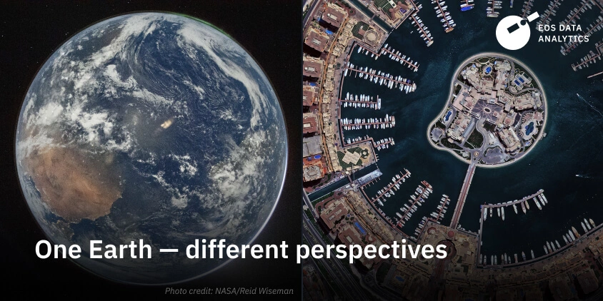
Commander Reid Wiseman’s “Hello, World” shot from the Orion’s porthole has instantly become the defining image of a new era in space exploration. It perfectly illustrates the delicate nature of our world when set against the vast, dark backdrop of the cosmos.
While there is high interest in the Moon mission live feeds and breathtaking photos, this orbital perspective is more than just inspiring. For those of us on Earth, a mission to the Moon reminds that our planet is a single, interconnected system. From 400,000 kilometers away, individual details fade, but large-scale weather systems and ocean currents become strikingly clear.
However, high-resolution photos from a space mission to the Moon or the thousands of images captured daily by near-Earth satellites are only the starting point. Raw imagery isn’t particularly helpful on its own. Whether you’re running a business or a government project, you get the most out of satellite images when combining them with analytical algorithms and expert eyes.
At EOSDA, we bridge the gap between these raw orbital images and actual business decisions. We take massive sets of satellite data and run them through our own analytical pipelines, automating the heavy lifting like identifying crop types or estimating carbon stocks. By turning a complex data stream into a practical tool for everyday monitoring and risk assessment, we live up to our core mission: space solutions for Earth problems.
The real challenge, however, is that different industries need different answers from the same orbital view. Looking at a coastal region might mean tracking erosion for a government agency, but for a logistics firm, it’s about monitoring port activity.
We handle this by developing custom analytical logic from the ground up, adjusting everything from the data layers to how the final insights are delivered. This might involve creating specific vegetation indices for AgTech or building change-detection algorithms for mapping mine expansion. By tailoring the analytical logic to the industry, we ensure the output fits directly into an existing professional workflow.
How do these tailored models translate into actual results? While the technology stays in orbit, the impact is felt directly across global supply chains, city planning offices, and conservation zones. By narrowing the focus to specific indicators, we help organizations manage large-scale operations without the need for constant boots-on-the-ground inspections.
Here is how different industries are using this intelligence today:
- Business operations. We help businesses manage large-scale operations, verify supply chain compliance with ESG standards, and maximize resource use efficiency with data-driven insights.
- Government and regional monitoring. Authorities use satellite analytics to track urban expansion, detect illegal construction, and manage public land more effectively.
- Environmental and land management. Our models are tuned for early detection of environmental stress and landscape changes across large areas. For instance, in our project in the Coimbra region of Portugal, we use these insights to monitor wildfire risks and help local communities protect their natural resources.
- Infrastructure and risk. We provide custom change-detection tools that automatically alert teams to any new construction or land shifts, keeping both the environment and the workers safe.
Ultimately, we rely on this orbital perspective because some problems are simply too big to manage on the ground. Satellite data gives us a scale and repeatability that manual inspections can’t match, for example, checking thousands of hectares in seconds instead of weeks. It also provides a broader situational awareness, allowing us to monitor remote or dangerous areas from a safe distance. By catching tiny changes over months or years, we can spot trends that would be invisible to someone standing on the ground.
While the NASA Moon mission encourages us to look further into the cosmos, it also gives us the best possible view of our own home. At EOSDA, we take that unique vantage point and apply it to the environmental and operational challenges we face today, ensuring that space-age innovation serves the people living on Earth.
Recent articles

EOSDA to Monitor Wildfires in Portugal Using Satellite Data Under ESA’s InCubed Programme
The company signed a contract with ESA to create an innovative satellite-based solution for forest monitoring and wildfire prevention.

EOSDA Forecasts Yields For 2025 In Saskatchewan
EOSDA created RM-level crop yield forecasts for Saskatchewan to address limitations of official data. The project shows how satellite and weather inputs reveal local yield changes during the season.

Digital Tools Improve Soil Health And Yields In Mexico
EOSDA and ITTA supported a Guanajuato farm with contour-line planning, monitoring tools, and practical guidance to reduce soil erosion and improve yields in the long run.