Weather constraints often make accurate rice field monitoring in Indonesia difficult, impacting the credibility of production forecasts. To solve this, EOSDA initiated a project integrating weather-independent radar data with traditional optical imagery. This hybrid method provides a scalable foundation for long-term agricultural monitoring in the region.
Case Highlights
Challenge
Field-based rice data collection in Indonesia is costly and does not always provide consistent nationwide coverage. At the same time, dense cloud cover during key growth stages limits optical-only satellite monitoring.
Solution
EOSDA developed a rice field detection approach based primarily on Sentinel-1 SAR data, supported by Sentinel-2 optical imagery when available. The method focused on analyzing seasonal changes in flooding and vegetation growth to distinguish rice from other land cover types.
Outcome
The project established a scalable and reliable SAR-powered approach for consistent rice detection across cloud-prone regions of Indonesia.
Overview: Rice farming in Indonesia
Rice farming is central to Indonesia’s agricultural sector and food supply. The country consistently ranks among the top global rice producers and harvested around 53.1 million tons of paddy as of 2024 . Farmers usually grow two rice crops per year, and in well-irrigated areas up to three cycles are possible: the main wet season (October–December planting), followed by two dry seasons when irrigation is required.
Most rice is grown by smallholders on Java, Sumatra, Sulawesi, and Bali. Java remains the core production area due to fertile soils and established irrigation networks. However, rapid urban growth reduces irrigated land, while expansion into swamps and marginal areas faces low soil fertility and unstable water regimes. Yield growth has slowed in many regions due to land limits and declining returns from further intensification.
Climate variability adds further pressure. ENSO (El Niño-Southern Oscillation) strongly affects rainfall, delaying planting and reducing output in El Niño years . Aging irrigation systems and uneven water distribution also create differences between upstream and downstream farmers. In this context, accurate and timely rice field detection is essential to track planted area, monitor seasonal changes, and understand how land use, water access, and climate risks affect national production capacity.
Challenge: Operational limits and cloud cover in rice mapping
Rice production data in Indonesia is still largely based on field surveys using the Area Sampling Frame (ASF) method. While this approach is relatively simple to apply across large areas, its accuracy depends on the number and representativeness of samples. Coverage is limited, operations are costly, and results rely heavily on human resources . This makes it difficult to obtain consistent and timely information at scale.
At the same time, accurate data is essential for sustainable production, food security planning, and effective agricultural policy. Indonesia’s geography and environmental diversity add further complexity. Many rice fields are spread across remote or hard-to-access areas, making regular ground verification challenging. As a result, gaps in coverage and delays in reporting can affect decision-making.
Satellite monitoring can improve coverage and operational efficiency. However, a major challenge is that peak rice growth often coincides with the monsoon season. During this period, dense cloud cover frequently blocks optical satellite imagery. This limits the use of optical-only approaches and increases uncertainty in crop mapping.
SAR technologies, such as Sentinel-1 and high-resolution systems like COSMO-SkyMed, have shown strong potential in overcoming these limitations in pilots and workshops. They can provide near-real-time information on planted areas, planting dates, and crop damage.
Solution: Integrating radar and optical data for rice mapping
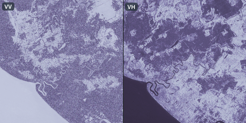
The solution offered by EOSDA was built around satellite data that can capture rice field dynamics throughout the season. Sentinel-1 SAR data served as the primary source, as it provides stable observations regardless of clouds or precipitation. Sentinel-2 optical data was used as a complementary source during cloud-free periods to support interpretation and validate results.
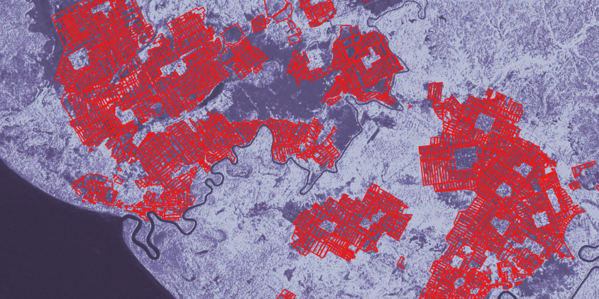
The general logic of our approach relied on the seasonal pattern of rice cultivation. Rice fields are flooded during planting, which marks the start of the season, and later show increasing surface roughness as vegetation develops. These temporal patterns allow rice fields to be separated from other land cover types such as forests, urban areas, and other crops.
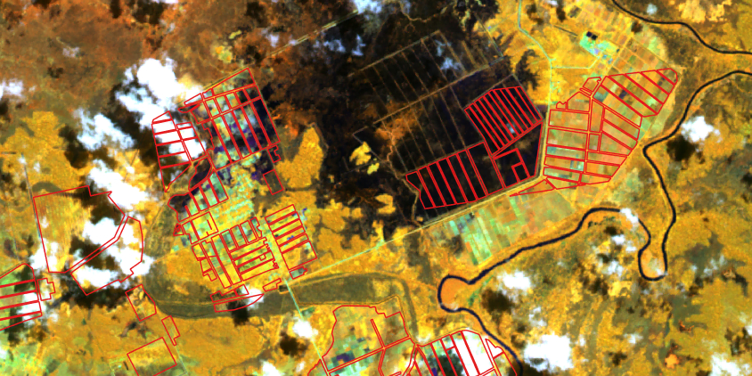
When cloud-free images were available, optical detection relied on two main approaches:
- multispectral composites combining channels sensitive to water, soil moisture, and vegetation enabled visual confirmation of flooded fields at early stages;
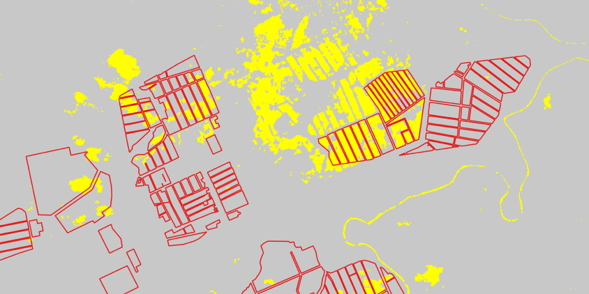
- spectral index analysis, highly effective during the initial flooding and transplanting stages, was used to generate masks highlighting flooded rice areas. However, once rice entered the active tillering phase and vegetation covered the water surface, additional crop classification masks were needed to distinguish rice from other crops.
While optical imagery provides important detail, it cannot guarantee stable monitoring throughout the season. Frequent and persistent cloud cover during key rice growth stages in many farming regions of Indonesia significantly reduces the number of usable optical images. To avoid these gaps, a data source unaffected by weather is required.
Thus, radar data analysis formed the core of EOSDA’s rice field detection solution. The approach included:
- radar composites, where SAR data is combined into RGB composites to clearly separate rice fields from other types of land cover;
- temporal amplitude analysis (studying changes in radar backscatter over time) to identify flooding and vegetation development stages;
- early-season water detection masks to locate newly flooded fields.
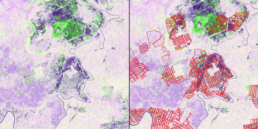
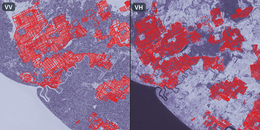
The key advantage of SAR data for rice field detection is not only its weather independence, but also its sensitivity to changes in surface water and canopy structure over time. By focusing on amplitude changes across the season, we can detect the transition from water-covered paddies to developed canopy and accurately detect rice fields.
Outcome: Consistent rice mapping in cloud-prone regions
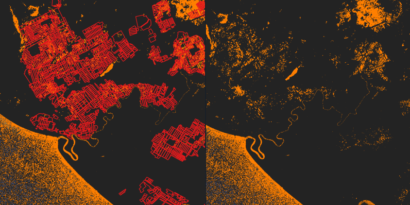
EOSDA’s project confirmed that radar monitoring (for example, based on Sentinel-1) is the most reliable way to identify rice fields across Indonesian regions. Unlike optical imagery, SAR data provided stable observations throughout the season, regardless of cloud cover or rainfall. This allowed consistent mapping even during peak monsoon periods, when optical images were often unavailable.
Temporal backscatter changes over time became the key signal for identifying rice. The clear shift from flooded surfaces to dense vegetation created a distinct seasonal pattern. These dynamics allowed rice fields to be separated from other land cover types with a high level of confidence.
As a result, EOSDA established a stable and scalable approach to rice field detection. Further development will focus on hybrid algorithms that combine radar structural information with optical spectral detail to improve accuracy and add more granularity to the final maps.
Turn high-tech satellite data into actionable solutions for your business.

Recent articles

EOSDA Forecasts Yields For 2025 In Saskatchewan
EOSDA created RM-level crop yield forecasts for Saskatchewan to address limitations of official data. The project shows how satellite and weather inputs reveal local yield changes during the season.

Digital Tools Improve Soil Health And Yields In Mexico
EOSDA and ITTA supported a Guanajuato farm with contour-line planning, monitoring tools, and practical guidance to reduce soil erosion and improve yields in the long run.
EOSDA Models Climate Change Impact On Sugarcane Yields
EOSDA modeled future temperature, rainfall, and other climate impacts on Veracruz sugarcane. The results help growers plan long-term adaptation strategies, including timing, varieties, and irrigation.