Agriculture API That Scales With Your AgTech Solution
Power up your software and workflows with satellite-powered agriculture analytics and build advanced, market-ready agtech solutions backed by our scalable farming APIs.
-
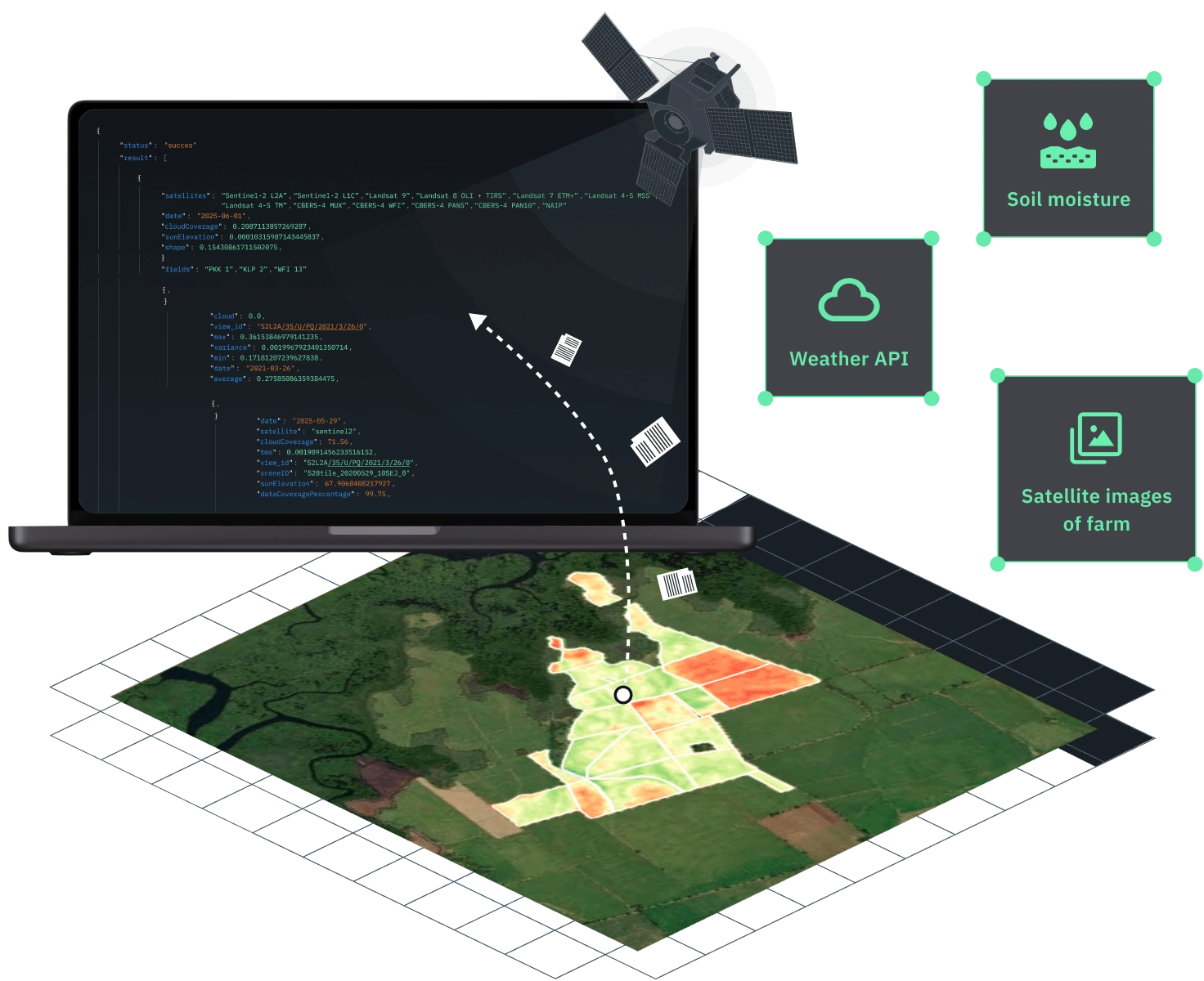
Agri satellite imagery API
- 15+ ready-to-use vegetation indices
- 20+ preset and custom band combinations
-
Soil moisture API
- Soil moisture records available from 2015
- 250×250m spatial resolution
-
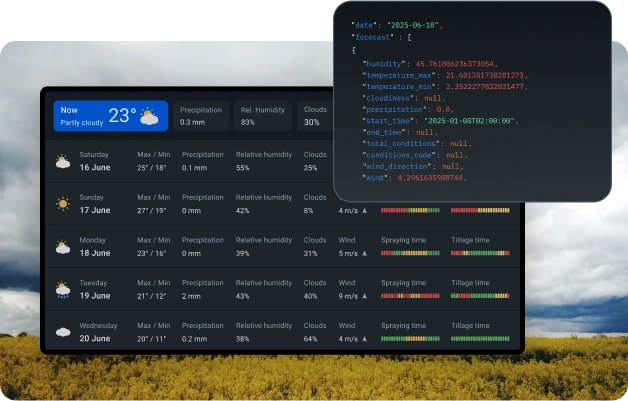
Weather API
- Site-specific historical weather records
- Local 14-day agriculture weather forecasts
-
VRA maps
- Vegetation maps
- Productivity maps
Who benefits from our agriculture data API
What's inside the EOSDA farm data API for you
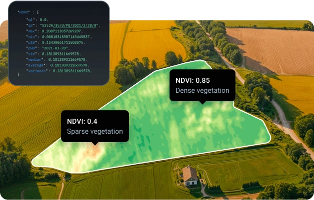
NDVI & оther vegetation indices
- Access a collection of 15+ predefined vegetation indices (NDVI, NDSI, NDWI, RECI, NDMI, SAVI, ARVI, EVI, GCI, SIPI, NBR, MSI, ISTACK, FIDET, NDRE, CCCI, and MSAVI)
- Create custom indices using supported spectral bands to fit your farm analysis needs.
- Monitor plant health with precise satellite data
- Leverage satellite-derived data to enhance crop analytics and implement precision agriculture practices
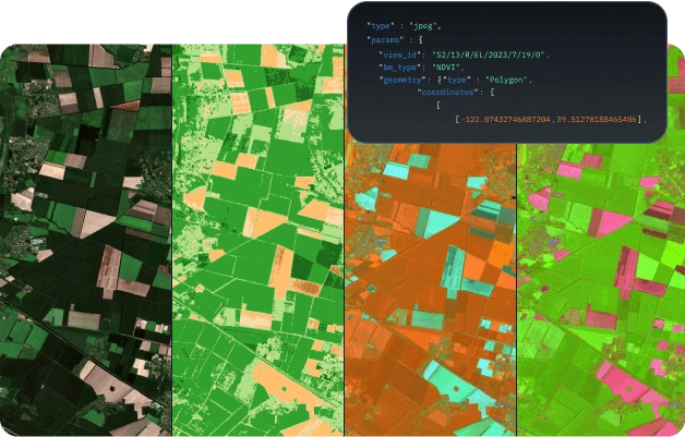
Agriculture satellite imagery
- Use the information derived from optical satellite imagery for your area of interest (AOI) within defined time ranges
- Get visualizations for your chosen area of interest, with options like natural color or various indices related to agriculture
- Render slippy map XYZ raster tiles for any selected scene
- Access standardized satellite agriculture imagery from multiple providers in a single, consistent format.
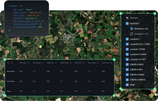
Historical and actual statistics
- Tap into 10+ years of agriculture statistics to identify and analyze trends
- Retrieve statistical metrics about plants (average, standard deviation, etc.) from optical imagery for any defined AOI, using selected band math expressions and time periods
- Access accurate soil moisture insights generated by our proprietary algorithm, available since 2016
- Benefit from farming datasets sourced from 9 satellites, including Sentinel-2 and Landsat 9.
Agricultural weather data
- Get real-time and historical weather analytics for your target farming area
- Access key weather parameters, including temperature, precipitation, humidity, wind speed, heat index, dew point, and cloud cover
- Obtain 3-day localized forecasts for your selected farming area of interest
- Explore past conditions for any chosen time frame and location using historical weather.
Your quick start to the EOSDA agricultural API
Create an account and obtain your personal access key
Easily integrate the API into your agricultural products or analytics workflow
Start receiving real-time agricultural insights and historical records on demand

FAQ
FAQ about the agriculture API
What is an agriculture data API?
An agriculture data application programming interface is a bridge allowing developers to access satellite-derived crop data and local weather analytics via code.
What data does EOSDA provide through the API?
Through the application programming interface, EOSDA provides you with the following data for farming: NDVI imagery and other vegetation indices, field boundaries, weather forecasts, historical plant and climate records, and more.
Is the EOSDA API Connect suitable for small-scale farms?
Yes, our agriculture monitoring application programming interface is suitable for farms of any size, from small-scale to corporate ones.
Can I integrate the EOSDA API Connect into my existing farming app or CRM?
Absolutely, our REST-based application programming interface is compatible with most apps, CRMs, and digital platforms for agriculture and can be easily integrated with them.
Does EOSDA API Connect offers a free trial?
Yes, we offer a free trial/demo access for testing purposes, available by request.
How does the payment system work?
You pay for requests to EOSDA API Connect, not for the area. We offer several packages (plans) with varying request limits, so you can choose the one that best suits your plant monitoring needs. All packages include access to agriculture satellite imagery, related statistics, and weather analytics.